Weather Hazards Flashcards (copy)
1/38
There's no tags or description
Looks like no tags are added yet.
Name | Mastery | Learn | Test | Matching | Spaced | Call with Kai | Chat |
|---|
No analytics yet
Send a link to your students to track their progress
39 Terms
Why is the Equator Hot?
Receives insolation (exposure to the sun’s rays) all year round
Less atmosphere to pass through so less heat is absorbed
Insolation is concentrated in a small area
Why are the poles cold?
6 months of darkness
More atmosphere to pass through so more heat is absorbed
Insolation is spread over a large area
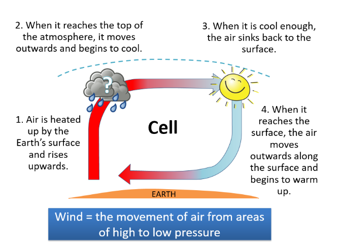
Low Pressure
Warm air rises
As it rises it cools and condensation takes place
This leads to rainfall
High Pressure
Cold air is sinking
This does not allow clouds to form so the skies are clear
It can be warm or cold depending on how far it is from the Equator
A circulation cell:
Global Atmospheric Circulation Model
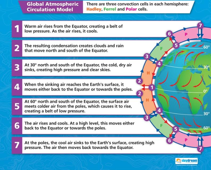
Surface winds move from…
As they move, they are curved due to…
Surface winds move from areas of high pressure to areas of low pressure.
As they move, they are curved due to the spinning of the Earth called the Coriolis Effect
Location of tropical storms
They form between 5-30 degrees north and south of the Equator where the seas are warm enough (27°C)
They not do not form on the Equator as there is no Coriolis effect
There must be low wind shear (this means clouds can grow tall without being ripped apart)
They form in summer and autumn
Oceans must be 60-70m deep to provide heat and moisture
Formation of tropical storms
Air is heated above the surface of warm tropical oceans
Warm air rises producing rain storms and clouds
Lots of thunderstorms join together to create one large storm
The storm begins to spin due to the Coriolis effect creating a calm eye in the centre and a dangerous eyewall
Air sinks at the eye so it is calmer and rises in the eyewall so it is more powerful
The storm gains energy as it moves across the ocean
When the storm reaches land, the storm loses energy
Why do storms eventually lose their energy?
Friction with the land slows them down
As they travel over land, their energy supply is cut off
They move further north or south away from the Equator where the seas are too cold to sustain them
Structure of a Tropical Storm
At the centre of the storm is an eye where air sinks (high pressure) creating clear skies and calm conditions
Air rises the most rapidly in the eyewall which is the most dangerous part of the storm with the strongest wind and rain
Rain bands with storms and thunder surround the eye and the eyewall
Storms spin anticlockwise in the northern hemisphere and clockwise in the southern hemisphere
Predicting Weather for an Approaching Storm
If you had to predict the weather conditions that area would face as a storm approaches, this would be the forecast
Wind and rain would slowly increase
There may be storms
Wind speeds and rain would increase until the eyewall passes when they are the strongest
There would be a period of calm as the eye passes over
The wind speed and rain would increase to their strongest again as the second eyewall passes over
Wind speeds and rain would slowly decrease as the storm moves away
Tropical storms are measured using the…
Saffir-Simpson scale
The most dangerous impacts from tropical storms are…
storm surges, strong winds and flooding from rainfall.
A storm surge is where…
the ocean surface is drawn upwards due to the low pressure storm above. This increases the surface level of the sea and then strong winds blow the water inland as the storm approaches.
Primary Effects of Typhoon Haiyan |
6300 killed – mostly by the storm surge
$12 billion of damage
Over 600 000 displaced
40 000 homes damaged
90% of Tacloban destroyed
30 000 fishing boats destroyed
75% of farmers and fisherman lost their jobs
400mm of rain caused flooding
Secondary Effects of Typhoon Haiyan |
14 million people affected
6 million lost their source of income
Flooding caused landslides that blocked roads
Power supplies were off for over a month
Airlines slowed which prevented aid
Outbreaks of disease
Looting and violence in Tacloban city
Livelihoods and education disrupted
An oil leak from an oil barge caused forests and fishing waters to be polluted
Rice prices rose by 12%
Immediate Responses to Typhoon Haiyan
Emergency aid arrived 3 days later
International governments and aid agencies responded quickly
US aircraft carrier George Washington and helicopters assisted
1200 evacuation centres set up
UK sent shelter kits
The Philippines Red Cross delivered food aid
Long Term Responses to Typhoon Haiyan
The UN and other countries donated financial aid, supplies and medical support
Over $1.5billion in foreign aid was given
Rebuilding of roads, bridges and the airport
‘cash for work’ programmes to pay people to clear debris
Rice farming and fishing quickly re-established but coconut farming will take longer
Oxfam replaced fishing boats – a valuable source of income
‘build back better’ scheme meant thousands of new homes built away from flood risk areas
More cyclone shelters built to accommodate people evacuated and a new storm surge warning developed
How Might Climate Change Affect Tropical Storms?
Sea surface temperatures in the tropics have increased by 0.25-0.5°c.
The distribution of storms may increase as sea surface temperatures increase and allow their formation
Example
Hurricane Catarina (2004) struck the east coast of Brazil a category 2 and the first ever storm to affect this region which is usually too far south.
Storm events may become more common in regions such as this
Frequency: The general consensus is that overall frequency of tropical storms will not increase, but out of the total number, more will be higher category storms.
Intensity of hurricanes is expected to increase.
From 1995-2005 average wind speed of storms have increased by 15%
As sea surface temperatures continue to increase, there will be more power for tropical storms leading to strong winders
As temperatures in the atmosphere increase, it will be able to hold more moisture and so rainfall levels will increase
As sea levels rise, storm surges could become stronger
Why are some experts doubtful about climate change affecting tropical storms?
Some people argue that tropical storms have not been recorded for long enough for current patterns to be linked to climate change; satellites have only accurately measured tropical storms since 1960. Other arguments include impacts increasing due to population growth, not the strength of tropical storms. Hurricanes could also follow a natural variation cycle which as yet is unknown.
How can we reduce risks from tropical storms?
Monitoring and prediction
Monitoring a hurricane involves taking measurements of wind speed, pressure, rainfall, height etc…
Satellites are able to measure many of these with radar and infrared sensors
Supercomputers are used to store and process the huge number of measurements that are collected
Hurricane Hunters travel through the storm taking measurements using sensors that they release into the storm
As satellites monitor tropical storms, experts try to predict the path or the track that the storm will take.
However, forecasters only have a 20-25% chance of knowing exactly where a tropical storm will hit 48hrs in advance of landfall.
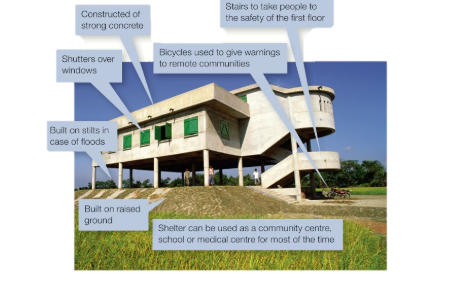
How can we reduce risks from tropical storms?
Protection
Building and evacuation centres must be able to protect people from strong wind, rain and storm surges.
The image below shows a typical evacuation centre in a LIC.
Typical protection methods include:
Reinforced windows, doors and roofs to withstand strong winds
Storm drains to take away rainwater
Sea walls to protect from storm surges
Houses close to the coast on stilts
Planting mangrove forests that protect from storm surges
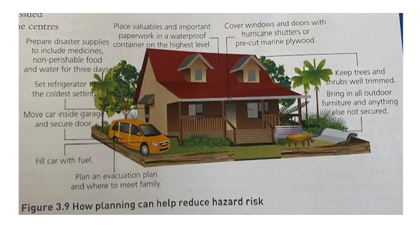
How can we reduce risks from tropical storms?
Planning
Planning to reduce the tropical storm hazard is mostly about raising individual and community awareness. People need to understand the potential dangers and be able to respond.
Early warning systems, cyclone shelters and greater awareness have helped reduce the death toll from cyclones in Bangladesh. The number of deaths have decreased by more than 100-fold in the past 40 years.
Climate meaning
the long term weather conditions of an area usually over a period of 30 years
Weather meaning
the day-to-day conditions of the atmosphere
What are some examples of extreme weather that the UK has experienced?
Droughts
Flooding
Lightning and thunder
Snow
Strong winds
Heavy rainfall
Heatwaves
Evidence of Extreme Weather in the UK
2003 Heat wave: over 2000 people died due to the heat, roads melted
Severe flooding in 2013/14 in Somerset
The Beast from the East
Why does the UK experience extreme weather?
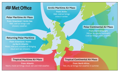
UK Roundabout
Jet stream
UK Roundabout
The UK is a meeting point where several different weather systems can have an affect.
This is the reason the weather can be so varied and why extreme weather can have an affect.
Tropical air masses bring warm weather
Polar air masses bring cold weather
Continental air masses bring dry weather
Maritime air masses bring wet weather
Jet Stream
The jet stream is a strong current of air that usually travels over the UK.
When the jet stream moves south over the UK, it drags down cold weather from the poles
When the jet stream moves north over the UK, it pulls up warm weather from the tropics
The jet stream is getting stuck due to climate change leading to longer lasting more intense weather events, because it halts the normal progression of weather systems, holding high-pressure (heat/drought) or low-pressure (rain/storms) systems over the same region for extended periods.
Is UK Weather Becoming More Extreme?
Yes: Average temperature is increasing
Temperatures have increased by 1°c since 1980
Dec 2020 was the coldest on record for over 200 years
July 2019 was the warmest on record
Warming Atlantic Ocean temperatures will lead to more intense rainfall coming in to the UK
Even though summers could become drier, rainfall events will become more intense leading to flash flooding
No:
A few extreme weather events is not evidence: there needs to be a long term trend
The Atlantic Ocean follows a natural cycle of warming and cooling
The jet stream getting stuck could be natural and not caused by climate change
Future predictions are uncertain and there is no scientific consensus
What are the benefits of extreme weather?
Warm weather can increase sales of ice cream, UK holiday bookings, suntan lotion sales
What was the Beast from the East?
The Beast from the East was an extreme weather event that affected the UK in late February and early March 2018.
It was characterised by low temperatures, heavy snow and strong winds, resulting in widespread disruption.
stratospheric warming disrupted the jet stream, allowing cold winds from Siberia, Russia to travel as far as the UK.
Beast from the East social impacts
ten people died
Some rural towns and villages were cut off for days and faced difficulties getting food supplies
Hundreds were stranded in cars on roads and motorways.
Many road traffic incidents - more than 8000 collisions
Emergency services experienced increased demand and it took longer for them to respond to call outs due to the difficult conditions on the roads.
Beast from the East economic impacts
The cost to the UK economy was estimated to be at least £1bn a day due to closed businesses and commuters unable to get to work.
British Airways cancelled hundreds of short-haul flights from airports like Heathrow
Stranded lorries and trains led to delays in resource distribution that affected many businesses
Thousands of businesses experienced power outages as heavy snow brought down power cables.
Beast from the East environmental impacts
Snow melt and heavy rain caused widespread flooding across the UK, including southwest England and Yorkshire
Freezing conditions made it difficult for farmers to care for some livestock
responses to the Beast from the East
traffic management: Approximately 4000 gritters and snow ploughs were deployed across the UK to keep major roads and transport routes clear, allowing emergency vehicles to operate. The military rescued stranded drivers and helped transport essential workers like NHS staff.
weather warnings: The Met Office issued early and frequent weather warnings, using the highest ‘Red’ level alerts in the southwest of the UK and amber alerts in other at-risk areas.
energy conservation: The National Grid issued a "gas deficit" warning, encouraging large businesses to reduce their gas usage. This was to ensure there was enough supply for essential services and heating people’s homes. In addition to this, the government encouraged households to be mindful of energy use, to help stabilise the supply during periods of peak energy demand.
Shelter and Support for Vulnerable Populations: Organisations like the Red Cross provided blankets, camp beds and food to people who were stranded, for example at Glasgow Airport. Local authorities opened community centres and public spaces as temporary shelters for homeless people and others vulnerable to the cold.
Long Term Responses to the Beast from the East
Following the Beast from the East, there was discussion about improving winter preparedness in the UK, including:
●better snow clearance systems
●better public communication of weather warnings
●improved infrastructure to withstand extreme cold, e.g. more gas storage
Some experts linked the Beast from the East to the increased risk of extreme weather as a result of climate change.