Hydrology Midterm
4.3(3)
Studied by 24 peopleCard Sorting
1/130
Earn XP
Description and Tags
Last updated 8:46 AM on 3/23/23
Name | Mastery | Learn | Test | Matching | Spaced | Call with Kai | Chat |
|---|
No analytics yet
Send a link to your students to track their progress
131 Terms
1
New cards
Hydrology
* Comes from the Greek words **hudor** meaning **water** and **logy** meaning **a study of.**
* Has origins in the New Latin word **hydrologia**
* An earth science that refers to the scientific study of water and its properties, distribution, movements, and effects on Earth's surface, soil, and atmosphere.
* Has origins in the New Latin word **hydrologia**
* An earth science that refers to the scientific study of water and its properties, distribution, movements, and effects on Earth's surface, soil, and atmosphere.
2
New cards
Atmospheric processes
cloud condensation, precipitation
3
New cards
Surface processes
snow accumulation, overland flow, river flow, lake storage.
4
New cards
Subsurface processes
infiltration, soil-water storage, groundwater flow.
5
New cards
Interfacial processes
evaporation, transpiration, sediment water exchange
6
New cards
* hydropower generation
* navigation
* water quality control
* thermal pollution
* recreation and the protection and conservation of nature
* contributions to **functional design** (e.g., location and height of the dam) by developing design criteria, and to **water resources management** by establishing the hydrological boundary conditions to planning (inflow sequences, water resources assessment).
**Hydrologists** are traditionally concerned with the supply of water for domestic and agricultural use and the prevention of flood disasters. However, their field of interest also includes:
7
New cards
• Sustainable agriculture (foods for the growing population).
• Environmental protection and management.
• Water resources development and management.
• Prevention and control of natural disasters.
• Control problems of tidal rivers and estuaries.
• Soil erosion and sediment transport and deposition
• Mitigation of the negative impacts of climatic change.
• Water supply
• Flood and drought control.
Hydrological science has both pure and applied aspects. Understanding the engineering hydrology science is essential for:
8
New cards
Traditional water management
has focused on providing freshwater resources to the needs of humans, livestock, commercial enterprises, agriculture, mining, industry, and electric power.
9
New cards
1950
Theoretical approaches in hydrology have been increasingly developed due to the development of digital computers since
10
New cards
**Hydrology**
is used in engineering mainly in connection with the design and operation of hydraulic structures.
11
New cards
1. data collection
2. methods of analysis
Two phases of the topics that Hydrology deals with:
12
New cards
* estimates of extremes rarely observed in a small data sample
* hydrologic characteristics at locations where no data have been collected (such locations are much more numerous than sites with data)
* estimates of the effects of human actions on the hydrologic characteristics of an area
* hydrologic characteristics at locations where no data have been collected (such locations are much more numerous than sites with data)
* estimates of the effects of human actions on the hydrologic characteristics of an area
Typical hydrologic problems involve:
13
New cards
Water
• is found everywhere on the earth, is one of the most basic and commonly occurring substances.
• the only substance on earth that exists naturally in the three basic forms of matter, i.e., liquid, solid, and gas.
• the only substance on earth that exists naturally in the three basic forms of matter, i.e., liquid, solid, and gas.
14
New cards
Hydrologic cycle
the constant interchange of water from the oceans to the atmosphere to the land and back to the ocean.
15
New cards
Soil moisture
The effect of infiltration is to increase the
16
New cards
water returns to the atmosphere through soil evaporation and by transpiration from plants and trees.
If the moisture content is less than the field capacity of the soil
17
New cards
the water percolates downward to become ground water.
If the moisture content becomes greater than the field capacity
18
New cards
Field capacity
moisture held by the soil after all gravitational drainage
19
New cards
Evaporate, Infiltrate, or Fills the Depressions.
The part of precipitation that falls into puddles and depressions can
20
New cards
Depression storage
Low places on the ground where water is held and is not available for overland flow or surface runoff.
21
New cards
Detention storage
* the flow path that must be filled with water before flow can occur overland and in the natural and/or manmade drainage systems.
* it is temporary since most of the water continues to run off after the rainfall ceases.
* it is temporary since most of the water continues to run off after the rainfall ceases.
22
New cards
seepage into streams and lakes, as capillary movement back into the root zone, or it is pumped from wells and discharged into irrigation systems, sewers, or other drainage ways
The precipitation that percolates down to ground water is maintained in the hydrologic cycle as
23
New cards
Precipitation
* in chemistry, it refers to material falling out of suspension.
* when studying weather and from meteorology, it refers to all forms of liquid or solid water particles that form in the atmosphere and then fall to the earth's surface.
* when studying weather and from meteorology, it refers to all forms of liquid or solid water particles that form in the atmosphere and then fall to the earth's surface.
24
New cards
Infiltration
the downward movement of water from the land surface into the soil profile.
25
New cards
Ddry soil (or just soil)
has a defined capacity for infiltrating water. The capacity can be expressed as a depth of water that can be infiltrated per unit time, such as inches per hour.
26
New cards
Evaporation
is the transformation of water from liquid to gas phases as it moves from the ground or bodies of water into the overlying atmosphere.
27
New cards
Solar radiation
the primary source of energy for evaporation
28
New cards
Evapotranspiration Process (ET)
* used to describe the sum of evaporation and plant transpiration from the Earth's land surface to atmosphere.
* an important part of the water cycle
* an important part of the water cycle
29
New cards
**Evaporation**
accounts for the movement of water to the air from sources such as the soil, canopy interception, and waterbodies.
30
New cards
Transpiration
accounts for the movement of water within a plant and the subsequent loss of water as vapor through stomata in its leaves. Evapotranspiration is an important part of the water cycle.
31
New cards
Evapotranspirator
an element such as a tree that contributes to evapotranspiration.
32
New cards
Condensation Process
the transformation of water vapor to liquid water droplets in the air, creating clouds and fog.
33
New cards
Groundwater
the water which occurs in the saturated zone of variable thickness and depth below the earth’s surface.
34
New cards
a. Precipitation
b. Infiltration
c. Evaporation
* Solar radiation
d. Evapotranspiration Process (ET)
* Evaporation
* Transpiration
* Evapotranspirator
e. Condensation Process
f. Groundwater
b. Infiltration
c. Evaporation
* Solar radiation
d. Evapotranspiration Process (ET)
* Evaporation
* Transpiration
* Evapotranspirator
e. Condensation Process
f. Groundwater
Main elements of Hydrologic Cycle
35
New cards
• Atmospheric processes
• Surface processes
• Subsurface processes
• Interfacial processes
• Surface processes
• Subsurface processes
• Interfacial processes
Physical properties that are studied by hydrology:
36
New cards
a. Precipitation and runoff (visible components)
b. Infiltration
c. Transpiration
d. Percolation
e. Groundwater recharge
f. Interflow
g. Groundwater discharge
b. Infiltration
c. Transpiration
d. Percolation
e. Groundwater recharge
f. Interflow
g. Groundwater discharge
The hydrologic cycle, illustrated in Figure 2, shows the pathways where water travels as it circulates throughout global systems by various processes. **The components of this hydrologic cycle:**
37
New cards
a. Air temperature
b. Pressure
c. Humidity
d. Wind
e. Solar Radiation
b. Pressure
c. Humidity
d. Wind
e. Solar Radiation
Meteorological parameters that are used to study the hydrologic processes:
38
New cards
* Precipitation
* Runoff
* Transpiration
* Evaporation
* Runoff
* Transpiration
* Evaporation
These hydrologic processes are:
39
New cards
Air Temperature
is measured by Thermometers located 1.25 m above the ground and sheltered.
40
New cards
Mercury thermometer
measures maximum temperature
41
New cards
Alcohol thermometer
measures minimum temperature
42
New cards
Humidity
the water vapor (moisture) content in the air or other gases
43
New cards
Psychrometer
measures humidity
44
New cards
Relative Humidity (Rh)
the air's capacity of absorbing moisture and can be expressed as a percentage
45
New cards
Dew point (Td)
\- the temperature at which 𝑒𝑣 reaches 𝑒𝑠 for the same conditions and water vapor starts to condense.
\- It can be computed using eq. 1 if T is replaced by Td and the normal vapor pressure is considered as saturated one.
\- It can be computed using eq. 1 if T is replaced by Td and the normal vapor pressure is considered as saturated one.
46
New cards
Anemometer
counts the number of rotations which is used to measures wind speed (W)
47
New cards
Wind vane
measured direction of wind
48
New cards
Wind speed
is measured by units of Knot or mph.
where:
1 Knot = 1.852 km/h
1 mph = 1.61 km/h
where:
1 Knot = 1.852 km/h
1 mph = 1.61 km/h
49
New cards
Power law profile equation
it expresses the relationship between wind speed and elevation.
50
New cards
Solar radiation
the source of energy on the earth and it is measured by units of Watt/m2 and KJ/m2.
51
New cards
Radiometer
measures solar radiation in micro-meter 10−6 m
52
New cards
Net radiation (Rn)
an important term used in some methods of estimating evapotranspiration.
53
New cards
**Monsoon**, the **Inter-Tropical Convergence Zone,** and **Tropical Cyclones.**
Rainfall in the Philippines is brought about by different-causing weather patterns and among them— dominating causes are the
54
New cards
Monsoon
the seasonal change in atmospheric circulation and precipitation associated with the asymmetric heating of land and sea.
55
New cards
Northeast Monsoon
Southeast monsoon
Southeast monsoon
Two monsoons in the Philippines:
56
New cards
Northeast Monsoon
* wind from the northeast
* it affects the country from the month of November to March
* it affects the country from the month of November to March
57
New cards
Southeast monsoon
* wind from the southeast
* begins as early as mid of April and ends in November
depending on location
* begins as early as mid of April and ends in November
depending on location
58
New cards
Inter-Tropical Convergence Zone (ITCZ)
* formed as a point where the trade winds converge forces the
air up into the atmosphere.
* it appears as a band of clouds consisting of rain showers with
occasional thunderstorms.
air up into the atmosphere.
* it appears as a band of clouds consisting of rain showers with
occasional thunderstorms.
59
New cards
Northern hemisphere
Trade winds move in southwesterly direction
60
New cards
Southern hemisphere
Trade winds move northwesterly direction
61
New cards
Tropical Cyclones
* are characterized by a low-pressure center where winds of varying intensive blow around the center
* are classified according to maximum winds near the center
* are classified according to maximum winds near the center
62
New cards
Tropical Depression - Winds from 45 to 63 KPH
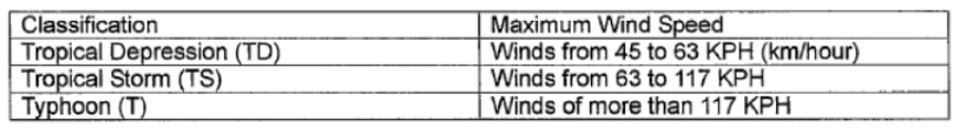
Tropical Storm - Winds from 63 to 117 KPH
Typhoon - Winds of more than 117 KPH
Tropical Storm - Winds from 63 to 117 KPH
Typhoon - Winds of more than 117 KPH
Classification of Tropical Cyclones
63
New cards
Water budget
* relation between water volume in the globe that is considered to be constant but changes from a phase to another
* states that the change in the storage within a certain domain is equal to the summation of the inflow, outflow, underground flow, evaporation, and precipitation.
* is accounting of the volume of flow rate of water in all possible
locations.
* states that the change in the storage within a certain domain is equal to the summation of the inflow, outflow, underground flow, evaporation, and precipitation.
* is accounting of the volume of flow rate of water in all possible
locations.
64
New cards
Precipitation
* in chemistry refers to material falling out of suspension.
* when studying weather and from meteorology, it refers to all forms of liquid or solid water particles that form in the atmosphere and then fall to the earth's surface
* to the hydrologist, it is the general term for all forms of moisture emanating from the clouds and falling to the ground.
* the primary input parameter of the hydrologic cycle.
65
New cards
a. Rain
b. Drizzle
c. Snow
d. Hail
e. Sleet
b. Drizzle
c. Snow
d. Hail
e. Sleet
Various forms which Precipitation occurs:
66
New cards
Rain
* is precipitation that is in the liquid state when it reaches the
earth.
* form of precipitation in which separate drops of water fall to
the Earth's surface from clouds.
earth.
* form of precipitation in which separate drops of water fall to
the Earth's surface from clouds.
67
New cards
Drizzle
– liquid precipitation that reaches the surface in the form of drops that are less than 0.5 millimeters in diameter.
68
New cards
Snow
* a frozen water in a crystalline state.
* occurs when the layer of the atmosphere from the surface of
the earth through the cloud is entirely below freezing.
* occurs when the layer of the atmosphere from the surface of
the earth through the cloud is entirely below freezing.
69
New cards
Hail
* a frozen water in a 'massive' state. Hail is a product of very
intense thunderstorms.
* is rarely seen when the surface air temperature is below
freezing.
* forms as a byproduct of strong updrafts that exist in
thunderstorms.
intense thunderstorms.
* is rarely seen when the surface air temperature is below
freezing.
* forms as a byproduct of strong updrafts that exist in
thunderstorms.
70
New cards
Cumulonimbus clouds
that are associated with thunderstorms can grow to heights where the temperature is below freezing. Drops of water will rise up with the upward directed wind as they collide with other droplets and grow larger. This will eventually result in the droplet freezing into a hailstone.
71
New cards
Sleet
* a melted snow that is an intermixture of rain and snow.
* is nothing more than frozen raindrops.
* occurs when there is a warm layer of air above a relatively
deep sub-freezing layer at the surface.
* usually doesn't last long and mainly occurs ahead of warm
fronts during winter months.
* is nothing more than frozen raindrops.
* occurs when there is a warm layer of air above a relatively
deep sub-freezing layer at the surface.
* usually doesn't last long and mainly occurs ahead of warm
fronts during winter months.
72
New cards
* Dynamic or adiabatic cooling
* Mixing of air masses having different temperatures
* Contact cooling with the Earth
* Cooling by radiation
* Mixing of air masses having different temperatures
* Contact cooling with the Earth
* Cooling by radiation
Condensation may be attributed to one or more of the following causes:
73
New cards
Dynamic cooling
most important cause of condensation
74
New cards
* Dew
* Frost
* Fog
* Frost
* Fog
**Condensation forms** commonly associated with radiational and contact cooling are:
75
New cards
* Latitude (high in latitudes of rising air and low in latitudes of descending air)
* Elevation (precipitation increases with elevation).
* Distance from moisture sources.
* Position within the continental land mass.
* Prevailing wind direction
* Relation to mountain ranges (more rain on windward sides than leeward sides)
* Relative temperatures of land and bordering oceans
* Elevation (precipitation increases with elevation).
* Distance from moisture sources.
* Position within the continental land mass.
* Prevailing wind direction
* Relation to mountain ranges (more rain on windward sides than leeward sides)
* Relative temperatures of land and bordering oceans
The average annual precipitation on certain locations is a function of:
76
New cards
**Precipitation**
can be classified by the origin of the lifting motion that causes the precipitation. Each type is characterized by different spatial and temporal rainfall regimens.
77
New cards
a. convective storms
b. orographic storms
c. cyclonic storms.
d. hurricane or tropical cyclone (often added in the types of storms, and is a special case of the cyclonic storm)
b. orographic storms
c. cyclonic storms.
d. hurricane or tropical cyclone (often added in the types of storms, and is a special case of the cyclonic storm)
Types of storms:
78
New cards
Convective
Precipitation from convective storms results as warm moist air rises from lower elevations into cooler overlying air. Heating of air at the interface with the ground, the heated air expands with a result of reduction of weight and the air will rise
79
New cards
summer thunderstorm
The characteristic form of convective precipitation is the
80
New cards
Orographic
* it results as air is forced to rise over a fixed-position
geographic feature such as a range of mountains.
* it is due to mechanical lifting of moist air masses over natural
barriers such as mountains.
geographic feature such as a range of mountains.
* it is due to mechanical lifting of moist air masses over natural
barriers such as mountains.
81
New cards
Cyclonic precipitation
is caused by the rising or lifting of air as it converges on an area of low pressure.
82
New cards
Extra-tropical cyclones or continental storms.
Air moves from areas of higher pressure toward areas of lower pressure. In the middle latitudes, cyclonic storms generally move from west to east and have both cold and warm air associated with them. These mid-latitude cyclones are sometimes called
83
New cards
Continental storms
occur at the boundaries of air of significantly different temperatures.
84
New cards
**a. Warm front** – warm air is the aggressor
**b. Cold front** – cold air is the aggressor
**b. Cold front** – cold air is the aggressor
Type of Fronts:
85
New cards
Front
type of air movement, where one has warm air being pushed into an area of cool air, while the other has cool air pushed into an area of warmer air.
86
New cards
Cold front
shows a much steeper slope of the interface of warm and cold air usually resulting in rainfall of shorter duration and higher intensity. Some depressions are died-out cyclones.
87
New cards
surface water temperature greater than 29°C (84°F)
Hurricanes, typhoons, or tropical cyclones develop over tropical oceans that have a
88
New cards
Hurricane
has no trailing fronts, as the air is uniformly warm since the ocean surface from which it was spawned is uniformly warm
89
New cards
**non-recording cylindrical container type** or the **recording weighing type, float type and tipping-bucket type.**
Measuring precipitation covers rain, hail, snow, rime, hoar frost, and fog, and is traditionally measured using various types of rain gages such as the
90
New cards
* Attempting to collect rain data in a hurricane can be nearly impossible
and unreliable (even if the equipment survives) due to wind extremes.
* Rain gauges only indicate rainfall in a localized area. For virtually any
gauge, drops will stick to the sides or funnel of the collecting device,
such that amounts are very slightly underestimated, and those of .01
inches or 0.25 mm may be recorded as a trace.
* Another problem encountered is when the temperature is close to or
below freezing. Rain may fall on the funnel and freeze, or snow may
collect in the gauge and not permit any subsequent rain to pass
through. Rain gauges, like most meteorological instruments, should
be placed far enough away from structures and trees to ensure that
any effects caused are minimized.
Limitations of Rain gauges:
91
New cards
* The rim of the collector should have a sharp edge.
* The area of the aperture should be known with an accuracy of 0.5%.
* Design is such that rain is prevented from splashing in or out.
* The reservoir should be constructed to avoid evaporation.
* In some climates the collector should be deep enough to store one
day's snowfall.
* The area of the aperture should be known with an accuracy of 0.5%.
* Design is such that rain is prevented from splashing in or out.
* The reservoir should be constructed to avoid evaporation.
* In some climates the collector should be deep enough to store one
day's snowfall.
The requirements for gauge construction are:
92
New cards
a. Standard Rainfall Gauges
b. Automated Rain Gauge
c. Optical Rainfall gauges
d. High Precision Single-Unit Rain Gauge
b. Automated Rain Gauge
c. Optical Rainfall gauges
d. High Precision Single-Unit Rain Gauge
Rainfall Gauges:
93
New cards
Standard gauges
* measure precipitation at or near the ground, and are observed at least once a day. The sizes of the gauges are made big enough to collect more than the average one-day or maximum 1-2 hours precipitation which differs according to various climatic conditions.
* are also commonly used to measure both rain and snow, and the latter affects fundamentally the form and dimensions of a particular national gauge (snow gauges are bigger).
* **The height of the gauge orifice varies** between **zero and more than 1m** above the ground.
* are also commonly used to measure both rain and snow, and the latter affects fundamentally the form and dimensions of a particular national gauge (snow gauges are bigger).
* **The height of the gauge orifice varies** between **zero and more than 1m** above the ground.
94
New cards
Automated Rain Gauge
There are **electronic rain gauges** that measures rainfall and are also self-emptying and frost proof. The basic idea is the rain collector’s measuring spoon being automatically tipped and emptied when the pre-adjusted water weight has been reached.
95
New cards
Weighing bucket
that moves a pen downward with the rainfall accumulating in the collecting bucket.
96
New cards
Optical Rainfall gauges
These have a row of collection funnels. In an enclosed space below each is a laser diode and a phototransistor detector. When enough water is collected to make a single drop, it drips from the bottom, falling into the laser beam path. The sensor is set at right angles to the laser so that enough light is scattered to be detected as a sudden flash of light. The flashes can be translated to amount of water and the rate of flashing can represent the time scale.
97
New cards
High Precision Single-Unit Rain Gauge
The bucket, 4" in diameter, measures each rain drop, displays it on the digital display with 3/8" numerals, and then empties itself. Simply place it outside on a hard, level surface and watch it record rainfall up to 99.999 in. Convenient one touch reset button lets you keep annual, monthly, or stormby-storm totals. The unit has no moving parts, gold-plated sensors for reliability, and is not damaged by freezing conditions.
98
New cards
* Data loggers
* Infrared recorders
* Wireless
* Data logging rain gauges
* Infrared recorders
* Wireless
* Data logging rain gauges
Other types of modern rain gauges are:
99
New cards
Radar
* an object detection system that uses electromagnetic waves to identify the range, altitude, direction, or speed of both moving and fixed objects such as aircraft, ships, motor vehicles, weather formations, and terrain.
* was coined in 1941 as an acronym for Radio Detection and Ranging.
* was originally called **Radio Direction Finder (RDF)** in the United Kingdom, in order to preserve the secrecy of its ranging capability.
* was coined in 1941 as an acronym for Radio Detection and Ranging.
* was originally called **Radio Direction Finder (RDF)** in the United Kingdom, in order to preserve the secrecy of its ranging capability.
100
New cards
Radar dish – or antenna
, transmits pulses of radio waves or microwaves which bounce off any object in their path.