Extreme Weather -- Exam 1
1/74
There's no tags or description
Looks like no tags are added yet.
Name | Mastery | Learn | Test | Matching | Spaced |
|---|
No study sessions yet.
75 Terms
Weather
Everyday atmospheric conditions of a particular place over a short period of time
Climate
Aggregate of weather (averages and extremes) at a place over an extended period of time
Why do we have weather?
Sun causes weather, specifically weather is due to the differential heating received on Earth. Warm air and moisture @ equator moves towards poles, cold air and moisture @ poles move to equatorial. Atmospheric struggle for equilibrium creates changing weather
Weather Severity Continuum
Benign Weather —> gentle, mild pleasant
Nuisance Weather —> Inconvenient, no significant issues
Severe Weather —> Potential to cause serious damage or loss of life
Extreme Weather —> Unexpected, unusual, unpredictable, or never-before seen weather events
Normal Value
The average and extreme values of weather for a place over a period of 30 years
Helps in describing the climate and is used as a base to which current conditions can be compared
“New” normal calculated every 10 years
NWS Mission
Provide weather, hydrologic, and climate forecasts and warnings for the US , its territories and ocean areas for protection of life and property
Outlook
Used to indicate that a hazardous weather event may develop, gives time to prepare
Weather Statement
Special weather statement that may be issued by the NWS for hazards that have not yet reached warning or advisory status
Advisory
Weather conditions are expected to cause a significant inconvenience, not serious enough to warrant a warning
Watch
Used when the risk of a hazardous weather event has increased significantly, but its occurrence, location, and timing is still uncertain
Issued when there is potential in 48 hours
Warning
Issued when a hazardous weather event is occurring, is imminent, or has a very high probability of occurring
Used for conditions posing a threat to life and property, 12-18 hours
“Ready”, “Set”, “Go” Concept
Three-tiered concept to convey severity
ex) Hydrologic Outlook (R) —> Flood Watch (S) —> Flash Flood Warning (G)
How do civil emergencies differ from NWS alerts?
Issued by government entities, may relate to NWS emergencies but differ in their scope
Local, state, and federal levels
Empowered to perform actions that would not normally be permitted, spend money that isn’t budgeted, enact emergency plans
Wireless Emergency Alerts (WEA)
Potentially life-saving emergency messages, usually less than 90 characters, that are sent directly to your phone by authorized government alerting authorities through your mobile carrier
"Ordinary“ Warnings do not activate WEA, only those designated as catastrophic with threat tags like “emergency” are broadcasted
Heat Dome
Weather phenomenon consisting of extreme heat, caused when a strong high-pressure system traps hot air over a large area, and preventing it from escaping
Occurs over days or weeks
Forms when jet stream slows or stalls, leading to sinking air that compresses and heats the air below
Jet Stream
Fastest-moving part of the Rossby Wave, flows West to East, located at the top of the troposphere
Controls the location, strength, and direction of surface pressure systems
Zonal Jet Stream
Strong temperature gradient creates strong pressure gradient, which produces faster winds and zonal flow
Meridional Jet Stream
Weak temperature gradient, weak pressure gradient
Produces slower winds and meridional flow
Can cause extreme weather conditions
Jet Stream and Low-Pressure Systems
Air rises and cools, holds less moisture, higher relative humidity, precipitation
Can predict weather by knowing where the low-pressure system is going to go
Jet Stream and High-Pressure Systems
Air compresses and heats, holds more water, lower relative humidity
Ridge in jet stream can cause heat waves or domes (high-pressure)
Omega Block
Formation in jet stream, named for the shape of the ridge, looks like Greek letter, omega
If Omega Block is stationary, heat waves become heat domes because descending air compresses, warms air, and stalled heat dome diverts other weather around it
How does a heat dome self-sustain?
Omega Block traps a pocket of warm air, ground warms, loses moisture (easier to heat), absence of clouds causes sunlight to further heat the air, cloudy and cool air masses are re-routed around the dome
Sensible Heat
All heat energy is used to raise the surface temperature, can be “sensed”, DRY
Latent Heat
Some energy used to evaporate, some used to heat the surface, WET
Hurricane Season
June 1st - November 30th
Rules for Naming Hurricanes
6 Lists, rotated yearly, alternating male-female, organized alphabetically
Storms that cause exceptional damage have their names retired and replaced on their lists.
What are the necessary conditions for hurricane formation?
Warm waters, lifting mechanism, Coriolis Force (spin), low wind shear
Intertropical Convergence Zone (ITCZ)
Hot and wet air, changes location based on season
Spring Equinox: located over equator, no Coriolis, no hurricanes
Summer Solstice: Northern Hemisphere —> warm waters + Coriolis + lift = hurricanes
Winter Solstice: Southern Hemisphere —> warm waters + Coriolis + lift = hurricanes
Why don’t hurricanes form at the equator?
ITCZ has excellent lift + hot, wet air, but…
There is no Coriolis Force at the equator, no spin = no hurricane
Easterly waves in Trade Wind flow
Another lifting mechanism
Fast-moving trade winds converge with slow-moving trade winds, creates lift!
Spaghetti Models
Model showing the different potential paths for the eye of a hurricane, also shows forecast confidence
Narrow spread = high confidence
Wide spread = less certainty
How does wind shear impact tropical storm growth?
Low wind shear means surface and top winds are flowing in the same direction, high means different directions
If wind shear is high, storm cannot grow and loses power
What is the role of the Coriolis Force on a hurricane’s path?
Brings hurricanes across Atlantic Ocean, makes them turn and go up the coast or out to sea
Bermuda High
Semi-permanent high-pressure system, at center of BH air sinks, warm dry air, clear skies
Directs tropical systems, including hurricanes, acts like guide or wall, clockwise rotation
Hurricane Structure
Eye (relatively clear), eye wall (most intense winds and rains), spiral rain bands (due to outflow and cyclonic motion)
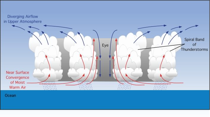
Eye Formation
Air in the eyewall is carried to the top of the storm, some flows outward, some at the very center sinks
Descending air is warm and dry, suppresses cloud formation, causes clear conditions
What regions of the hurricane are windiest?
Eye wall most intense winds, spiral rain bands can also be intense, wind from Southeast is much more intense due to rotational speed and forward motion
What is a hurricane’s cool wake and its impact?
Strong winds mix cold water from deep in ocean coupled with evaporation of warm water by the storm, leaving a trail of cool water in its path, makes it harder for following storms to develop/grow stronger
What is the impact of dry air and Saharan dust?
Saharan Air Layer (SAL) is an extremely hot, dry, and sometimes dusty layer of the atmosphere
As SAL is pushed out over the Atlantic, it creates an inversion, where air gets hotter with height, acts as a cap and prevents lift below it, limits moisture needed for development
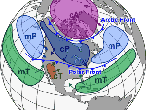
Air Masses
Wet = Maritime
Dry = Continental
Tropical, Polar, Arctic
Stable and Unstable Air
Stable air —> resists vertical motion, meaning if a pocket of air is pushed up, it will sink back to its original position, creates relatively horizontal movement, fair weather, layer clouds (stratus), smooth air, poor visibility, and steady precipitation, involves temperature inversion (air gets warmer with altitude)
Unstable air —> warmer and less dense than surrounding environment, continues rising, vertical motion promotes vertically developed clouds, can lead to showers and thunderstorms, temperature decreases with height
Tropical Storm Categories
Disturbance (organized) —> Depression (38mph) —> Storm (39-73mph) —> Hurricane (74+ mph, Cat 1-5 depending on wind speed)
Hurricane Dangers
Wind damage
Storm Surge: water being pushed toward shore by winds, low pressure raises water level, onshore winds pile up water, wave action, high tide
Inland Flooding: may affect places for hundreds of miles inland many days after hurricane has weakened or moved on
Hurricane watch vs. warning
Watch: hurricane possible in area, issued 48 hours in advance of anticipated onset of winds, prepare home and review evac plan
Warning: expected in area, hurricane preparation becomes difficult once winds reach tropical storm force, issued 36 hours in advance, complete preparations and immediately leave threatened area
Fujiwara Effect + Hurricane Sandy
Two hurricanes passing close by each other, usually stronger storm absorbs weaker one, similar strength will be pulled to each other, spin around and continue on their paths
Sandy: October 2012, storm merged with low pressure cell, created “superstorm” that generated powerful winds, heavy rainfall, record-breaking storm surge
2025 Hurricane Season
All Cape Verde Hurricanes!
Fernand: Early August, tropical storm, never made hurricane status, stayed out at sea
Gabrielle: Mid-September, tropical storm, warm waters led to rapid intensification, Hurricane! Cat 1 to Cat 4 in less than 24 hours, Bermuda High caused early turn (fish storm)
Humberto: Late September, HUGE, Late September, tropical storm, reached Cat 5 Hurricane status, followed closely by Imelda (Fujiwara Effect), Humberto caused dangerous surf, affected Northern Caribbean and US East Coast
Imelda: Late September, reached category 2, weakened, being pulled out to sea by Humberto due to Fujiwara effect, hit Bermuda early October
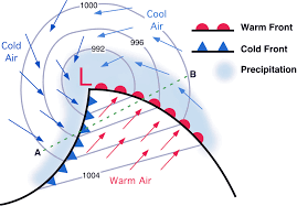
What is a mid-latitude, low pressure system?
a large-scale weather system forming between 30 and 60 degrees latitude, characterized by a center of low air pressure, form when cold, dense air from the poles meets warm, moist air from the tropics, creating a rotating storm with warm and cold fronts
How are low-pressure systems linked to the jet stream?
Jet stream guides location of low-pressure systems, divergence in jet stream causes air to rise, cyclonic flow
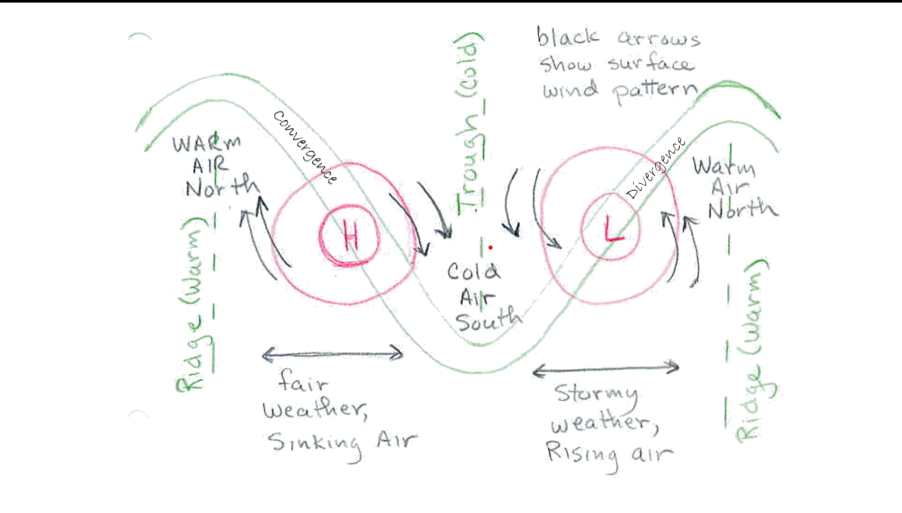
Structure of a surface low
Cold front, warm front, cyclonic (counter-clockwise) rotation
Thunderstorm
A cumulonimbus cloud that produces precipitation, lightning, and thunder
May cause other severe weather
Rainstorms without thunder (absence of lightning) cannot be classified as a thunderstorm
What is needed for a thunderstorm to develop?
Source of moisture (warm and wet airmass)
Unstable environment (air needs to rise)
Trigger for the storm’s updraft
Conditional Instability
High Convective Available Potential Energy (CAPE) exists with slightly warmer layer overlaying a warm, moist layer
Acts as a weak lid on updrafts forming in lower layer, keeps thunderstorms from forming early in the day
Inversion acts like lid on a tea kettle, storm rapidly builds
What are the various updraft triggers for a thunderstorm?
Heating of the surface —> warms air above it, air rises, convection = thunderstorm
Boundaries (Frontal, Subtle) —> dense cold front can propel warm air up quickly, leading to fast development, convection = thunderstorm
Low Pressure Cell —> associated with rising air, convection = thunderstorm
Stages of thunderstorm development
a. Cumulus stage - developing stage, rising updraft, growing cumulus clouds
b. Mature stage - updraft and downdraft coexist, heavy rain, lightning, hail
c. Dissipating - downdraft cuts off the updraft, storm weakens and eventually disappears
Structure of and within a thunderstorm cloud
Updraft —> rising warm, moist air that fuels vertical growth
Anvil —> flat, spreading top caused by strong hitting the tropopause
Downdraft —> caused by forming precipitation, falling rain and hail mixes with updraft
Charge separation —> ice crystals colliding creates negatively charged base and positively charged top, can cause lightning
Mammatus —> pockets of dense, sinking air within a thunderstorm's anvil or cloud base descend into warmer, drier air, sinking air descends, it cools due to evaporative cooling and forms pouch-like, rounded structures, often signal severe weather conditions
Gust front —> cool air spreading out from the downdrafts causes boundary of sudden, strong winds found at surface
Overshooting top —> an extremely strong updraft penetrates the tropopause, resulting in a dome over the troposphere
What is the mesocyclone and how does it form?
Mesocyclone: tilted, rotating updraft, tilt allows storm to last longer because the downdraft doesn’t choke out the updraft, rotation can lead to tornado formation, forms when changes in wind shear creates spinning layers
What are the two types of rain processes?
Collision Coalescence - tiny droplets accumulates on larger droplets, increasing in size until they fall as rain
Cold-Rain Process - Super-cooled liquid, water vapor, and ice crystals accumulate and form larger ice crystals that thaw as they fall from clouds
Heat lightning
Lightning close enough to see, but too far to hear, might head in your direction!
Hail formation
forms inside the updraft when cloud droplets are carried above the freezing level, strong updraft + long time in cloud = large hailstone, falls when the thunderstorm’s updraft can no longer support the weight of the hailstone
Wall cloud
downward extension of the mesocyclone, tornadoes extend from there
What is the significance of the radar hook?
signifies a supercell thunderstorm has a mesocyclone, that often leads to tornado formation
Funnels and scud clouds
Funnel clouds can lead to tornadoes, they have rotation
Scud clouds are non-rotating, more ragged appearance
Dynamic Pipe Effect tornado formation
Mesocyclone stretches, causes air below it to constrict its circulation leading to a tighter vortex, process proceeds earthward until the vortex is narrow at the ground, forming a tornado
Types of tornadoes
Rope Tornadoes —> smallest, most common
Cone Tornadoes —> narrower where they touch the ground than where they meet the base
Wedge Tornadoes —> can appear wider than they are tall, may contain multiple vortices, most destructive
Bow Echo
Line of thunderstorms shaped like an archer’s bow, can produce dangerous straight-line winds and occasionally tornadoes caused by rotations at the ends of the bow
Tornado Alley, why is it there?
Southern plains region prone to tornado formation, boundary between cold and warm air masses, warm, humid air from Gulf of Mexico meets cooler air from the North to create ideal environment for tornadoes to grow, the “dry line”
Tornado Watch + Warning Polygons
Watch —> the possibility of tornadoes over a specified area for a particular time frame (covers many counties for periods up to 6 hours)
Warning Polygon —> geographic shape drawn by the National Weather Service (NWS) to show the specific area where a tornado is occurring or is imminent
Enhanced Fujita Scale
Categorizes tornadoes by strength using the damage they cause as a gauge
Reasons: Better correlates damage with specific wind speeds
What are waterspouts and how are they formed?
rotating column of water-filled air, either "fair-weather” or “tornadic”, fair-weather form from non-thunderstorm clouds and build up from the water surface, strong temp gradient between warm water and cold overriding air and shifting winds near the surface, warm air rises, expands and cools, holds less water
Microbursts and related dangers
localized, powerful downdrafts in thunderstorms, cause intense outward-spreading winds upon impact with ground
Can cause aircraft accidents, building damage, downed trees and power lines