geography paper `1
1/437
There's no tags or description
Looks like no tags are added yet.
Name | Mastery | Learn | Test | Matching | Spaced |
|---|
No study sessions yet.
438 Terms
what is a natural hazard
natural process which could cause death injury or disruption to humans or destroy property and possessions
what is a natural disaster
natural hazard that has actually happened, extreme events which do not pose any threat to humans activity are nto counted as hazards
example of something that wouldn’t actually be considered a natural hazard
e.g a drought in a uninhabited desert or an avalanche in Antarctica
geological hazards
caused by land and tectonic processes, including volcanoes, earthquakes, landslides and avalanches
meteorological hazards
caused by weather and climate e.g tropical storms and other extreme weather e.g heatwaves and cold speels
hazard risk
the probability of people being affected by a hazard in a particular area
factors that can affect hazard risk: vulnerability
the more people that are in an area exposed to natural hazards, the greater the probability they will be affected by a natural hazard
factors that can affect hazard risk: vulnerability (example)
an area with high population density on a floodplain is very vulnerable to flooding cause by extreme weather and a city at the base of a volcano is very vulnerable to volcanic eruptions
factors that affect hazard risk: capacity to cope
the petter a population can cope with an extreme event, the lower the risk of them being severly affected
factors that can affect hazard risk: capacity to cope (example)
HICs are better able to cope with flooding as they can afford to build flood defences and evacuate people
factors that can affect hazard risk: nature of natural hazards (type)
the risk from some hazards is greater than others e.g tropical storms can be predicted and monitored, giving people time to evacuate but earthquakes happen very suddenly with no warning so its much harder to protect people
factors that can affect hazard risk: nature of natural hazards (frequency)
natural hazards that occur more often may carry a higher risk
factors that can affect hazard risk: nature of natural hazards (magnitude)
more severe natural hazards tend to have the greatest effects e.g a magnitude 9.0 earthquakes that struck Japan in 2011 killed over 150,000 people whereas a 6.3 magnitude earthquake in l’Aquila, Italy in 2009 killed around 3000 people
primary effects
primary effects of natural disasters are the immediate impacts caused by the natural hazard itself
secondary effects
secondary effects happen later on, often as a result of the primary effects
what areas can experience primary effects of natural hazards
buildings, food and water, electricity
primary effects of natural hazards (buildings)
buildings and roads are destroyed by earthquakes, volcanic eruptions or tropical storms, people are killed e.g when buildings collapse
primary effects of natural hazards (food and water)
crops and water supplies can be damaged or contaminated
primary effects of natural hazards (electricity)
electricity cables, gas pipes and communication networks can be damaged, cutting off supplies
what areas can experience secondary effects of natural hazards
triggers, aid, food and water, economy
secondary effects of natural hazards (triggers)
the initial hazard can trigger other hazards e.g earthquakes can trigger tsunami (enormous waves caused by seawater being displaced)
secondary effects of natural hazards (aid)
aid and emergency vehicles can’t get through because of blocked roads or bridges - this can cause more deaths
secondary effects of natural hazards (food and water)
a shortage of clean water and a lack of proper sanitation makes it easier for disease to spread, food shortages can occur if crops are damaged, livestock are killed or supply lines are blocked
secondary effects of natural hazards (economy)
the country’s economy can be weakened - damage to businesses can cause unemployment, and the reconstruction process can be very expensive
immediate responses to natural hazards (people)
evacuate people before the hazard occurs if possible, treat the injured and rescue anyone cut off by damage to roads or bridges and recover dead bodies to prevent disease spreading
immediate responses to natural hazards (provision)
provide temporary supplies of electricity and gas if regular supplies have been damaged, provide food, drink and shelter to people without homes and foreign governments or charities may send aid workers, supplies or financial donations
long term responses to natural hazards (repair)
repair homes or rehouse people who have lost their homes, repair or rebuild buildings, roads and railways and bridges and reconnect broken electricity, water, gas and communication connections
long term responses to natural hazards (improvement)
improve forecasting, monitoring and evacuation plans, improve building regulations so that buildings can withstand and similar hazards in the future, boost economic recovery e.g by promoting tourism
tectonic plates
the Earth’s crust (outer layer) is divided into slabs called tectonic plates that float on the mantle (a layer of semi molten rock)
two types of crust
tectonic plates are made up by two types of crust, continental crust which is thicker (30-50km) and less dense and oceanic crust which is thinner (5-10km) and more dense
why do tectonic plates move
the plates are moving because of convection currents in the mantle, the place where plates meet are called plate margins
destructive margins
where two plates move towards eachother, when an oceanic plate meets a continental plate, the denser oceanic plate is subducted and destroyed creating gas rich magma, volcanoes and ocean trenches occur here, where two continental plates meet the ground is folded upwards creating fold mounts
destructive margins (example)
along the west coast of South America, the oceanic Nazca plate is being subducted beneath the continental South American plate, creating the Atacama Trench
constructive margins
where two plates are moving away from eachother, magma rises from the mantle to fill gaps and cools, creating new crust
constructive margins (example)
the movement of the Eurasian plate and the North American plate away from one another is forming the mid Atlantic ridge
conservative margins
where two plates are moving sideways past eachother, or are moving in the same direction but at different speeds, crust isn’t created or destroyed
conservative margins (example)
at the San Andreas Fault, the Pacific plate is moving in the same direction as the North American plate but faster
occurrence of volcanoes at destructive margins
at destructive margins, the denser oceanic plate moves down into the mantle where it melts, a pool of magma forms which ten rises through cracks in the crust called vents, magma erupts forming a volcano
occurrence of volcanoes at constructive margins
the magma rises up into the gap created by the plates moving apart, forming a volcano
occurrence of volcanoes at hot spots
some volcanoes also form over parts of the mantle that are really hot (called hotspots) e.g in Hawaii
what happens when a volcano erupts
it emits lava and gases, some volcanoes emit lots of ash which can cover land, block out the sun and form pyroclastic flows (super-heated currents of gas, ash and rock)
occurrence of earthquakes at destructive margins
tension builds when one plate gets struck as it moves past eachother
occurrence of earthquakes at constructive margins
tension builds along cracks in the plates as they move away from eachother
occurrence of earthquakes at conservative margins
tension builds up when plates that are grinding past eachother get stuck
formation of earthquakes at all three plate margins (1)
earthquakes are caused by the tension that builds up at all three types of plate margin, the plates eventually jerk past eachother, sending out shock waves, these vibrations are the earthquake
formation of earthquakes at all three plate margins (2)
the shock waves spread out from the focus -the point in the Earth where the earthquakes starts, the waves are stronger near he focus and cause more damage
formation of earthquakes at all three plate margins (3)
the epicentre is the point on the Earth’s surface straight above the focus, earthquakes are measured using the moment magnitude scale
what is the moment magnitude scale
measures the amount of energy released by an earthquake, it is a logarithmic scale so a magnitude 7 earthquake would cause ten times as much ground shaking as a magnitude 6 earthquake
earthquakes of magnitude 6 and below
normally only cause slight damage to buildings, although they can be worse in very built up areas
earthquakes of magnitude 7 and above
can cause major damage and deaths
lots of people being in areas at risk from tectonic hazards (involuntary)
many people live close to volcanoes or in areas vulnerable to earthquakes, some people don’t have a choice as they may not be able to afford to move or they may not know the risk
lots of people being in areas at risk from tectonic hazards (voluntary)
many people choose to live in a hazardous region e.g around 1 million people live close to Mount Etna in Italy
why may people choose to live in areas at risk from tectonic hazards (familiarity)
they’ve always lived there, moving means leaving their jobs or families
why may people choose to live in areas at risk from tectonic hazards (wealthier countries)
in wealthier countries, effective monitoring and evacuation plans can minimise risk
why may people choose to live in areas at risk from tectonic hazards (government)
they’re confident that their government will support them after an earthquake or volcanic eruption, in 2001, the Italian government provided financial aid and tax breaks for local residents when Mount Etna erupted
why may people choose to live in areas at risk from tectonic hazards (farming)
the minerals from volcanic ash makes volcanic soil very fertile, attracting farmers e.g the mineral rich soil around Mount etna is ideal for producing grapes
why may people choose to live in areas at risk from tectonic hazards (tourism)
volcanoes are tourist attractions, so lots of people live nearby to work in the tourist industry, Mount Etna receives hundreds of thousands of visitors when it is erupting
management strategies
can reduce the number of people killed, injured, made homeless or left unemployed
management strategies to reduce the effects of tectonic hazards: monitoring (earthquakes)
seismometers and lasers monitor earth movements, and can be used in early warning systems to give a small but vital amount of warning before a large earthquakes occur
management strategies to reduce the effects of tectonic hazards: monitoring (volcano eruptions)
scientists can monitor the tell tale signs that come before an eruption, such as tiny earthquakes escaping gas, and changes in the shape of a volcano
management strategies to reduce the effects of tectonic hazards: prediction (earthquakes)
earthquakes cannot be reliably predicted, but scientists can forecast where they may occur by monitoring the movement of tectonic plates
management strategies to reduce the effects of tectonic hazards: prediction (volcano eruptions)
volcano eruptions can be predicted if scientists monitor volcanoes closely
management strategies to reduce the effects of tectonic hazards: protection (earthquakes)
new buildings can use reinforced concrete that absorb an earthquake’s energy, existing buildings and bridges can be strengthened with steel frames so they’re less likely to collapse and automatic shut off switches can turn off gas and electricity supplies to prevent fires
management strategies to reduce the effects of tectonic hazards: protection (volcanic eruptions)
buildings can be strengthened so they’re less likely to collapse under the weight of ash, trenches and barriers have been used to try to divert lava away from settlements, but with little success
management strategies to reduce the effects of tectonic hazards: planning (buildings)
future developments can avoid high risk areas
management strategies to reduce the effects of tectonic hazards: planning (services)
emergency services can prepare e.g by practising rescuing people from collapsed buildings
management strategies to reduce the effects of tectonic hazards: planning (educating people)
people can be educated so that they know what to do in event of a hazard
management strategies to reduce the effects of tectonic hazards: planning (government)
governments can plan evacuation routes to get people away quickly and safely
management strategies to reduce the effects of tectonic hazards: planning (emergency supplies)
emergency supplies like blankets, clean water and food can be stockpiled
global atmospheric circulation (1)
the transfer of heat from the equator to the poles by the movement of air, air moves due to differences in air pressure - wind blow from high pressure areas to low pressure areas
global atmospheric circulation (2)
the global atmospheric circulation system is divided into loops called cells, each cell has warm rising air that creates a low pressure belt and cool sinking air that creates a high pressure belt, each hemisphere has three cells

describe the movement of air between equator and poles (1)
the sun warms the Earth at the equator, causing the air to rise creating a low pressure belt, as the air rises it cools and moves away from the equator, 30 degrees north and south of the equator the cool air sinks, creating a high pressure belt
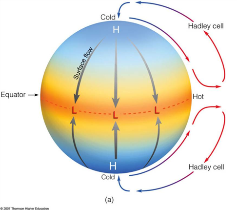
describe the movement of air between equator and poles (2)
at the ground surface, the cool air moves either back to the equator as trade winds or towards the poles as westerlies, these winds curve due to the Earth’s rotation - this is called the Coriolis effect

describe the movement of air between equator and poles (3)
60 degrees north and south of the equator, the warmer surface winds meet the colder air from the poles, the warmer air rises creating low pressure

describe the movement of air between equator and poles (4)
some of the air moves back towards the equator and the rest moves towards the poles, at the poles the cool air sinks, creating high pressure which is then drawn back towards the equator
examples of how global atmospheric circulation influences weather and climate (equator)
at the equator, the sun is directly overhead meaning the Earth’s surface receives a lot of solar radiation, so its hot, warm, most air rises and forms clouds so it rains a lot
examples of how global atmospheric circulation influences weather and climate (30 degrees north and south)
by the time air reaches 30 degrees north and south of the equator, it has released most of its moisture as rain, the dry air means there are few clouds and little rainfall so deserts are often found at this latitude
examples of how global atmospheric circulation influences weather and climate (60 degrees)
the UK lies close to the low pressure zone at 60 degrees north, warm rising air brings lots of clouds cover and rainfall, often as low pressure systems carried from the Atlantic by westerly winds
describe how pressure belts and surface winds are determined by global circulation
air moves in loops called cells from the equator to the poles back, which gives us surface winds and creates belts of high and low pressure that affects the climate - they’re why deserts are so dry and rainforests are so wet
where and when do tropical storms develop
develop between 5 and 30 degrees north and south of the equator when sea temperature is 27 degrees or higher and wind shear between higher and lower parts of the atmosphere is low
formation of tropical storms (1)
the warm surface water evaporates, rise and condenses into clouds, this releases huge amounts of energy producing powerful storms, creating an area of low pressure which increases surface winds, low wind shear prevents clouds breaking up as they rise so the storm stays in tact
formation of tropical storms (2)
easterly winds near the equator move tropical storms towards the rest, the storms spin because of the Coriolis effect
formation of tropical storms (3)
as the storm moves over the ocean, the energy from the warm water strengthens the storm, so wind speeds increase, storms lose energy when they move over land or cooler water as the energy supply from the warm water is cut off
where do the majority of tropical storms occur
majority of tropical storms occur in the northern hemisphere from August to October, while in the southern hemisphere most storms occur from December to April
general features of a tropical storms
circular in shape, hundreds of kilometres wide and usually last 7-14 days, they spin anticlockwise in the northern hemisphere and clockwise in the southern hemisphere
structure of a tropical storm: eye
the centre of the storm is called the eye, its up to 50km across and its caused by descending air, there’s very low pressure, light winds, no clouds, no rains and a high temperature in the eye
structure of a tropical storm: eyewall
the eye is surrounded by the eyewall, where there’s spiralling rising air, very strong winds (around 160km per hour), storm clouds, torrential rain and a low temperature
structure of a tropical storm: wind speed
towards the edges of the storm, the wind speed falls, the clouds become smaller and more scattered, the rain becomes less intense and the temperature increases
affect of climate change on tropical storms
global average sea surface temperatures have risen by 0.9 degrees Celsius since 1880 and are expected to rise more as a result of climate change
affect of climate change on tropical storms: frequency
oceans will stay at 27 degrees Celsius or higher for longer each year, so there’s a longer period when tropical storms can form, which may means there are more storms for each year
affect of climate change on tropical storms: frequency (example)
in the Atlantic, the number of tropical storms each decade seems to have increased, 16 of the last 24 years have had a higher than average number of hurricanes
affect of climate change on tropical storms: intensity
higher sea surface temperatures are likely to result in more evaporation and increased cloud formation so more energy is release which could mean storms become more powerful
affect of climate change on tropical storms (intensity) example
in the Atlantic, the number of major hurricanes has increased since 1970, 2014-2018 had almost twice as many major hurricanes as 1970-1975
reducing the effects of tropical storms from climate change through monitoring
storms can be monitored using radars, satellites and aircraft, computer models can then be used to calculate a storms predicted path
reducing the effects of tropical storms through climate change through predicting
predicting where and when a tropical strom is going to happen gives people time to evacuate and protect homes and businesses
reducing the effects of tropical storms through climate change through monitoring and predicting (example)
during Typhoon Haiyan, predicting the storm’s path helped authorities decide which areas needed to be evacuated
reducing the effects of tropical storms through climate change through planning (high risk zones)
future developments e.g new houses can avoid high risk areas such as low lying coastal zones
reducing the effects of tropical storms through climate change through planning (government)
governments can plan evacuation routes to ensure people can get away quickly
reducing the effects of tropical storms through climate change through planning (services)
emergency services can prepare for disasters by practising rescuing people from flooded areas
reducing the effects of tropical storms through climate change through planning (example)
after Typhoon Haiyan, volunteers started rescue simulations to better prepare for future storms