Marine Provinces
 Call Kai
 Learn
Learn Practice Test
 Spaced Repetition
 Match
Match Flashcards
 Knowt Play
1/21

Earn XP
Description and Tags
Vocabulary flashcards covering bathymetry, ocean basin features, continental margin structures, trenches, mid-ocean ridges, and hydrothermal vent types.
Name | Mastery | Learn | Test | Matching | Spaced | Call with Kai | Chat |
|---|
No analytics yet
Send a link to your students to track their progress
22 Terms
Bathymetry
The measurement of ocean depths and the charting of the shape or topography of the ocean floor.
Echo Sounder
The primary instrument for measuring ocean depth, invented in the 1920s, which works by reflecting sound waves off the ocean floor.
Sounding
The process of measuring ocean depth using a line weighted with a heavy load, first recorded by Poseidonus in 85 B.C.
Fathom
A unit of ocean depth measurement equal to 1.8meters (6feet).
Hypsographic Curve
A curve that shows the relationship between the height of land and the depth of the ocean across Earth's surface.

Passive Continental Margin
A coastal region surrounding an ocean basin (such as most of the Atlantic) that is not associated with plate boundaries and experiences little volcanism and few earthquakes.
Active Continental Margin
A coastal region located at a convergent subduction zone where the continental slope descends abruptly into a deep-ocean trench, accompanied by volcanism, earthquakes, and accretionary wedges.

Continental Shelf
A gently sloping, flooded extension of the continent that varies in width from 70 to 150km and frequently contains oil.
Continental Slope
A relatively steep structure inclined between 1^\circ\text{ and }25^^\circ that marks the seaward edge of the continental shelf and forms the boundary between continental crust and oceanic crust.
Submarine Canyons
Deep, steep-sided valleys cut into the continental slope that are formed and eroded primarily by turbidity currents.
Turbidity Currents
Downslope movements of dense, sediment-laden ocean water that erode submarine canyons and deposit sediment at the base of the continental slope to form deep-sea fans.

Continental Rise
A gradual incline located at the base of the continental slope in regions lacking trenches, composed of thick sediment accumulations deposited by turbidity currents.
Accretionary Wedge
A chaotic mass of deformed sediment and scraps of oceanic crust scraped off the subducting plate at an active continental margin.
Abyssal Plains
Extremely flat, level areas of the deep ocean floor extending from the base of the continental rise, formed by long-term suspension settling of fine sediment.
Seamounts and Guyots
Isolated volcanic peaks on the ocean floor, often formed near oceanic ridges; guyots are flat-topped seamounts.

Deep-Ocean Trenches
Long, narrow depressions representing the deepest parts of the ocean floor, formed where subducting lithospheric plates plunge into the mantle.
Mid-Ocean Ridge
A continuous underwater mountain range system spanning over 70,000kilometers (43,000miles) across all ocean basins, elevated about 2.5km above the seafloor and covering 23% of Earth's surface.
Ridge vs. Rise vs. Rift
A terminology distinction based on spreading rate and elevation: a ridge is slow-spreading and below sea level; a rise is fast-spreading and below sea level; a rift is slow-spreading and above sea level.
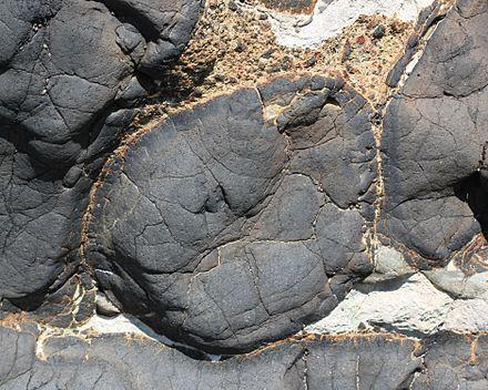
Pillow Lavas
Basaltic lava structures that solidify into rounded pillow shapes upon extruding into ocean water at mid-ocean ridges.
Warm Water Vents
Hydrothermal vents that emit ocean water at temperatures below 30∘C (86∘F).
White Smokers
Hydrothermal vents that emit water at temperatures ranging from 30∘C to 350∘C (86∘F to 662∘F).
Black Smokers
Hydrothermal vents that emit mineral-rich water at temperatures above 350∘C (662∘F).