Geography T3 - Hazardous environments
1/100
There's no tags or description
Looks like no tags are added yet.
Name | Mastery | Learn | Test | Matching | Spaced | Call with Kai |
|---|
No analytics yet
Send a link to your students to track their progress
101 Terms
Natural Event
something happening in the physical environment, such as a storm, volcanic eruption or earthquake.
hazard
potential source of harm, danger or adverse effects to people, poverty, or the environment.
Natural disaster
a natural event or hazard causing damage and destruction to property as well as personal injury and death.
disaster
sudden event, such as a natural calamity or human-made crisis, that causes significant damage, loss, or disruption to life, property, or the environment.
hazard risk
likelihood of an event causing harm to people, environment or economy
risk
probability that a hazard event will have harmful consequences
hazard vulnerability
the susceptibility of a community or area to harm from hazards due to factors such as geography, infrastructure, and preparedness.
what is an earthquake?
It is a sudden and brief period of intense shaking of the ground.
what causes earthquakes?
result of built up pressure when tectonic plates move
plate boundaries that causes earthquakes
In collision zones, subduction zones and conservative / transform plate margins:
(1) Tectonic plates grind against each other (because they move against each other or towards each other) and they can get stuck.
(2) Pressure builds as the plates continue to try to move and due to the increased friction
(3) Eventually, the plates jolt free and the pressure is released as energy (4) The energy passes through the Earth's crust as seismic waves which is the earthquake. (Note that seismic means: related to the earth)
In divergent / constructive plate boundaries:
(1) As plates move away from each other, the earth’s crust is stretched, causing faults (cracks and fractures in a tectonic plate).
(2) Magma rises to fill the space through the faults, adding pressure to the surrounding rocks.
(3) This pressure causes rocks to dislodge at the faults, which releases energy as seismic waves - an earthquake.
(4) As the plates move relative more smoothly than other plate boundaries, the earthquakes here are smaller and less destructive.
Why do the Mercalli Scale readings decrease away from the epicenter?
✅ Model Answer:
The Mercalli Scale measures the intensity of shaking and damage caused by an earthquake. The readings decrease away from the epicenter because the seismic energy is strongest at the epicenter, where the earthquake originates. As the seismic waves travel outward, they lose energy, so the shaking becomes weaker and causes less damage. Therefore, areas further from the epicenter experience lower Mercalli ratings.
tsunami
series of large ocean waves caused by significant disturbances, such as underwater earthquakes or volcanic eruptions
how are tsunamis formed
(1) Plates move towards each other at a subduction zone in the sea AND / OR an underwater volcanic eruption occurs.
(2) Sea above the epicenter is forced upwards (above the normal sea level) due to the plate movement / eruption and gravity pulls the seawater back to regular sea level - this causes large waves.
(3) These waves spread quickly outwards from the epicentre of the earthquake. This is known as propagation.
(4) As waves travel towards the land, the waves slow down as the water becomes shallower (and there is increased friction) and become taller. This is known as shoaling.
soil liquefaction
soil with high moisture lose their strength and stiffness due to earthquake shaking, causing them to behave like a liquid.
epicentre
point on the earths surface directly above focus
focus
point at which earthquake starts below the earths surface
tropical cyclones
are rotating, low pressure systems (intense circular storms) that originate over warm tropical oceans and are characterized by low atmospheric pressure.
what are tropical cyclones also called
hurricanes, typhoons or cyclones depending on location
what are volcanoes?
opening on earth’s crusts which allows magma to erupt onto earth’s surface as lava
what causes volcanic activity?
constructive, destructive and hotspots
DO NOT occur at collision boundaries and conservative boundaries
hotspot
a point at which material from deep inside the earth’s mantle is pushed to the surface. They are found within a plate - not at a plate boundary.
characteristics of volcanoes
magma chamber - molten rock (magma) is stored beneath the ground
main vent - channel which the magma travels to reach earths surface
secondary vent - smaller passage that connects to main vent where some magma escapes
crater - top of the volcano, bowl shaped hole, where lava, ash and gases come out during eruption
can be active, dormant or extinct.
Lava: this is molten rock that erupts onto the Earth's surface. Depending on its type, lava can flow slowly or rapidly to burn buildings, roads, and vegetation in its path.
Volcanic Ash: these are tiny rock, mineral, and glass particles ejected during an eruption. It can travel long distances in the atmosphere, causing respiratory issues, reducing visibility, and disrupting air travel. When it settles, ash can damage crops, contaminate water supplies, and collapse roofs due to its weight.
Volcanic Bombs: these are large fragments of molten rock ejected during a volcanic eruption. As they travel through the air, they often cool and solidify into larger fragments. Upon impact, volcanic bombs can cause damage to structures, ignite fires, or injure people and animals.
Gas Emissions: Volcanoes emit gases such as water vapor, carbon dioxide (CO₂), example, can lead to acid rain and affect air quality, while CO₂ emissions in low-lying areas can displace oxygen, creating suffocation hazards. ● and sulfur dioxide (SO₂). Some gases are harmless in small amounts, but large concentrations can cause health problems or environmental damage: SO₂, for Pyroclastic Flows: these are fast-moving, extremely hot clouds of gas, ash, and volcanic rock fragments. They flow down the sides of a volcano at speeds of up to 700 km/h and can reach temperatures over 1,000°C.
constructive/divergent plate boundary
(1) Two tectonic plates (either continental or oceanic) MOVE APART from each other.
(2) This is because of warm magma rising in the mantle (due to convection currents) and moving the overlying plates away from each other
(3) Magma rises to the surface to fill the gap and cools to form a new crust.
earth trembles
destructive/subduction plate boundary
(1) An oceanic and a continental plate or two oceanic plates move towards each other.
(2) The denser plate (the oceanic plate) sinks under the other plate.
(3) The plate that sinks melts due to the intense heat in the mantle and the friction.
energy released in form of seismic waves
collision zone
(1) Two continental plates move towards each other.
(2) Both crusts are of equal density
(3) So the crust is pushed upward and folds up to form a fold mountain.
conservative/transform plate boundary
(1) Any two tectonic plates move past each other
(2) They can move in opposite directions or in the same direction at different speeds
(3) The edges of the plate can catch on each other and result in friction
pressure released in form of seismic waves
characteristics of tropical cyclones
heavy rainfall
high wind speeds
high waves and storm surges
measures around 100-1000km across rotating clouds surrounding a central, called the eye
develop in tropical regions between 5-30 degrees north and south of equator
conditions for tropical cyclones
sea temperature above 26.5 (provides heat and mosture)
depth of warm water 50-60m (enough energy for continuous evaporation)
light wind shear (to maintain structure and prevent dissipation)
air near equator 5-20 latitude (enough coriolis force to spin in air)
step - by - step formation of tropical cyclones
warm ocean water heats air above it
evaporation occurs - warm, moist air rises causing low pressure
air cools and condenses forming cumulonimbus clouds and releasing latent heat
more warm air is drawn in, increasing the strength
coriolis effect causes rising air to spin (due to earth’s rotation) causing rising air to spin
storm organizes into a circular shape with a calm eye in the centre
becomes tropical storm when wind speeds exceed 119km/h
moves across ocean, powered by warm water, until it reaches land or cooler water, where it loses energy
coriolis force
sheers cyclones away from the equator and along curved paths
no coriolis force at equator so cyclones dont form
There is almost no effect from the Coriollis force at the equator and up to 5 degrees North and South of the equator. Thus, the winds cannot rotate in one direction and keep the clouds together to form tropical cyclones and no tropical cyclones are found here.
what natural events become a natural hazard in an indirect way?
volcanic eruption (releases ash into atmosphere + blocks sunlight leading to global cooling)
heavy rain (soaks soil and triggers landslides which can bury homes)
drought (leads to crop failure, livestock death, food shortages and famine + increase risk of wildfires)
earthquakes (can trigger massive tsunamies)
floods (stagnant water after flooding can spread diseases)
factors of the damage done by hazards
magnitude
frequency
duration/time
size
location
which plate boundaries do earthquakes occur at?
all plate boundaries
what are some factors that increase the risk that people face from natural hazards?
population density
level of development
infrastructure
remote areas
geographical location
low education
poor government response
hazard timing
what is used to measure magnitude of tropical cyclone?
saffir simpson scale from 1-5
what is used to measure earthquake magnitude(strength/power)?
richter scale or the moment magnitude scale
what is used to measure earthquake damage?
mercalli scale
what is used to measure volcanoes magnitude?
volcanic explosivity index
hazard management cycle
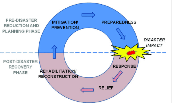
preparation
safety measures taken before an earthquake to minimize damage and loss of life.
buildings - preparation/mitigation
Increasing the earthquake-resistance of buildings is important as it isn’t the earthquake that kills people, but the collapsing buildings.
This includes:
● Using lighter building materials such as timber, aluminum and carbon fibre instead of concrete and bricks so that a collapsing building doesn’t hurt people.
● Flexible materials that sway with the seismic wave
● Reinforced structures that prevent it from collapsing such as cross-bracing
● Deep foundations in hard bedrock to steady the building
● Base isolators are devices placed under buildings to reduce shaking during earthquakes by letting the building move gently back and forth without following the intense shaking of the ground. It is like the building is on wheels: the building is kept safe as it is able to glide smoothly instead of shaking violently and so the people inside do not feel the earthquake as much and the building is steady.
● A damper is a large, heavy mass (often a steel or concrete block) suspended inside the building. When the building sways due to external forces (like wind or seismic activity), the damper moves in the opposite direction to counteract the motion.
buildings - resistance to tsunamis
-raised on stilts/ ground flood left open to allow water to flow underneath
-deep and reinforced foundations can anchor building securely
built away from shoreline or on higher ground to reduce exposure to tsunami waves
-seawalls, levees, natural barriers like mangroves to absorb wave energy + reduce flooding
-rooftop escape areas
remote sensing
use of satellite imagery and aerial (birds eye view) photography to monitor and analyse land changes caused by earthquakes
Geographic information systems (GIS)
technology that maps and analyzes spatial data to identify vulnerable areas and plan evacuation routes
japan - remote sensing system
national seismic hazard maps, headquaters of earthquake research promotion (HERP - gov organisation)
haiti - preparation system
ESRI or ArcGIS
warning and evacuation
earthquakes cannot be predicted, seismometers analyses areas at most risk, evacuate people to other areas after an earthquake.
japan - warning system
early warning system (EEW) prevented deaths in 2011 Tohuku earthquake
residents recieved warning on mobile phones a min before strong shaking, education played key role (drop-cover-hold) - stopped high speed trains and factory assembly lines
community based org (VOLUNTEER FIRE CORPS) use sirens, fire bells, loud speakers.
fire corps went door to door to help people move to higher ground in shiogama city
sri lanka - warning system
2004 tsunami, 250,000 killed. analysts say early warning system in indian ocean + community education would have mitigated the disaster
response
identify worst hit areas and access them, using GIS systems
rescue survivors from trapped buildings using lifting gear and dodgers to clear away rubble and debris
restore basic services like water, sewage, gas, electricity and communications
provide medical help
organise rationing and distributions of supplies
set up temporary shelters
provide transport for emergancy supplies
requires coordination and communication!!!
between all stakeholers and emergancy teams
japan - response system
p.m set up emergancy command centre in tokyo
rescue workers and 100,000 members of self defence force mobilised to deal w crisis
other nations sent out search and rescue teams
GIS for short term response and relief; United states geological survey (USGS) provided data to create system on arcGIS:
contains shakemap; measuring hoe people there felt the earthquake
has sources for education and real time postings by people on ground in those locations
long term planning (recovery process)
responses that can go on for months and years after a disaster
-rebuilding
-kick starting local economy
-considering mistakes made in disaster and implementing policies to prevent these from happening again using United nations disaster risk and reduction (UNDRR)
risk assessment
hazard mapping
rebuilding programs
risk assessment
determining the probability of a particular hazard happening + the scale of its possible impact on ppl and env
considers distribution, frequency scale, predictability of the hazard
hazard mapping
map where hazards are most likely to occur, helps gov plan where important services and infrastructure are (LAND USE ZONING)
rebuilding programs
reducing numbers of buildings and valuable services in high risk areas
retrofitting (ADDING OR CHANGING) buildings and bridges to make them more earthquake resistant
japan - long term planning
-transportation and services infrastructure at least partially restores weeks after
-repairs continued till train lines and major highways were fully operational
-temporary power outages and rolling blackouts due to fukushima plant
-gov provided 155billion + established cabinet level reconstruction agency to coordinate rebuilding efforts in tohoku area
-early 2015, nearly all debris removed
-3/4s planned coastal infrastructure
classifying wind
63-118km/h = tropical storms
above 120km/h = tropical cyclones
low vertical wind shear
little change in wind directions and speed from surface of earth to upper atmosphere
latent heat of condensation
clouds form due to water molecules cooling through condesations releasing heat. heat causes more air to rise and evaporate making storm larger.
low atmospheric pressure
air moves away from surface of the earth when water vapour evaporates, produces little pressure on surface. low pressure areas encourage more air to rise: moving air drags air particles behind like a train causing more wind and evaporation
why do tropical cyclones vanish
When a tropical cyclone makes landfall or moves over an area of cold water it no longer has a supply of warm, moist air to form wind so it loses speed and eventually vanishes.
eye
extremely low pressure center called ‘eye’
-calm and clear because cooler air sinks here so no clouds can be formed
-warm air that rises spirals upward and leaves space in center for air to sink
-there is more air rising than sinking so overall pressure on surface is low
eyewall
surrounds the eye and contains strongest winds and heaviest rainfall
movement of tropical cyclones
rotate and spin bevaise of coriolis force (force caused by earths rotation that makes air curve)
anticlockwise in northern hemisphere
clockwise in southern hemisphere
move across oceans and towards land
prevailing winds
-trade winds: move cyclone westwards from source
-westerlies:carry it eastward
summary of tropical cyclones
areas of low pressure (less than 950 mb [millibars]). This means that air is moving away from the surface of the earth, which results in low pressure on the surface of the earth.
● large systems (up to 2000 km wide).
● develop in tropical regions between 5 - 30 degrees north and south of the equator.
● rotating systems that move anticlockwise in the Northern Hemisphere and clockwise in the Southern Hemisphere.
● moved by prevailing winds (trade winds and westerlies) from areas they were formed to other regions.
● known as hurricanes (In the Atlantic Ocean and eastern North Pacific), typhoons (in the western North Pacific) and cyclones (In the Indian Ocean and South Pacific).
storm surge/ tide
abnormal rise in sea level accomanying a hurricane or other intense storm
what is the cause of a storm surge
high winds pushing the seawater towards the coast, causing it to pile up there. air moving upwards contribute slightly at the centre of the storm “pulling” water level up creating waves
megacity
city with population of at least 10million inhabitants
urbanisation
growth in the percentage of population that live in urban spaces such as cities and towns
how does urban areas differ from rural areas
economies
size
density of people and buildings
way of life
why rate of urbanisation in devloping/emerging countries are increasting
economic development in cities
encourages rural-to-urban migration (pull factor)
poverty (push factor)natural increase (of population) because of low death rates as there is better healthcare access
rural dilution
weakening of traditional rural culture and community due to influx of urban lifestyles and residents
agglomeration
a collection of settlements that develop because of people and trade concentrating at favorable locations:
-river crossing points (where humans can travel from one bank to another easily) allowing trade and transportation across areas
-estuaries at mouth of river - ideal for fishing etc.
-close to a needed mineral resource
-areas well defended naturally, preventing attack from outsiders
suburbs
areas of settlement developes
growth of a city: suburbanisation
town grows → explanding outwards + creating smaller groups of settlements w houses and places of development/services at a lower density than older parts of the town or city
occurs when:
improvements in transports
overcrowding, congestion, rising land prices, egenral residential decline in quality of life in older parts of town drive people out to look for areas elsewhere
migration from rural areas - cheaper land prices to build homes on
development of new businesses
result of agglomeration and suburbanisation = towns grow into cities
growth of a city: conurbation
when several towns, suburbs and cities join together into one vast continuous built up area
growth of a city: counter urbanisation
cities grow larger → competition for jobs, poor air quality, pollution, increased land prices → businesses and residents moving into smaller towns/cities/rural areas
some may move into dormitory settlements; only sleep in these settlements then commute to same place of work in main city; using urban services
rejuvenating a city
due to counter urbanisation → residents/businesses move out, leaving abandoned urban areas behind
urban re-imaging
urban rebranding
urban regeneration
urbanisation of suburbs
urban reimaging
changing the look of an area
urban rebranding
changing the way the area is know
urban regeneration
adressing issues like housing shortages, environment problems and economic decline within a city
urbanisation of suburbs
surburbs (areas with low-density development eg. house w spaced out gardens, few shopping complexes, large parks) these areas are developed to preserve more rural areas
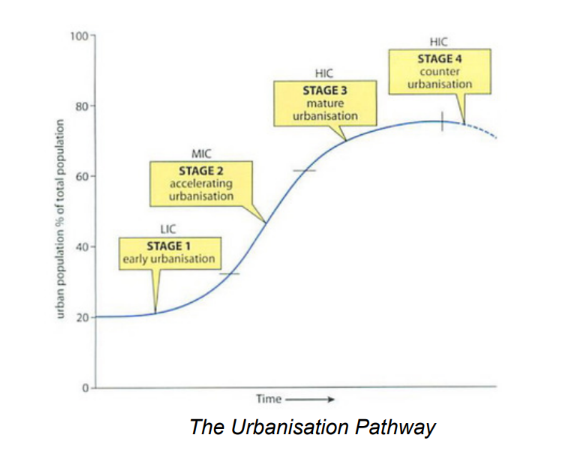
urbanisation pathway
shows how urbanisation varies as countries develop
millionaire city
a city with more than 1 million people
global/world cities
population of these are any size but places of prestige, status, power and influence (aka crucial hubs in growing world economy)
there are 31 cities
megacity trends
There are more big cities in developing countries compared to in the 1970s. In 1970
half of the ‘top ten’ biggest cities were found in developed countries and the other half
in developing countries. By the year 2000, only 2/10 were found in developed
countries.
The total numbers living in the largest cities have increased. In 1970, New York's
population (the then largest) had 16.5 million people. In 2000, New York had 16.3
million.
In 1900 there were just 2 millionaire cities - London and Paris. Now there are about 400.
The number of megacities are growing. In 1970, there were just 2. By 2010- 24, today
there are 35 megacities and over half are in Asia.
The UN estimated that by 2030 that there will be nearly 43 megacities.
reasons for growth in megacities
1. Economic development attracts more migrants for work and encourages the development of businesses, which further increases economic growth.
2. Population growth - this can be due to natural increase, rural to urban migration (especially by young adults, drawn to it by its ‘buzz’, employment and education opportunities).
3. Economies of scale - there are advantages gained from cramming as much as possible into one megacity than into a number of smaller cities, such as financial savings due to shorter transport distances and communication being easier.
4. Multiplier effect - As one large city is prospering, it will lead to more prosperity and growth. There are more jobs so more people come which means more people need goods and services, which creates more jobs etc.
deprivation
standard of living below that of the majority of people in a particular city, region or country + lack of access to a range of other things
Central business district (CBD)
-main business center of a city/town, referred as ‘downtown’
a. high concentration of offices, shops etc. high-density buildings + high land values
b. oldest part of the city
-industrial areas
-residential districts
-small shopping centres
why are similar land uses clustered together?
land values
a. land values is highest in the center
b. relatively high values are found along major roads leading to the centre + ring roads (roads that encircle a cirty)
c. radical roads (roads that extend from center of city like radius of a circle) and ring roads cross eachother bc better accessibility
d. businesses willing to pay large amounts because it is accessible for customers (businesses tend to cluster along these areas)
e. similar businesses afford same land value → leads to clusteringlocational needs
accessibility to customers, employees etcs.
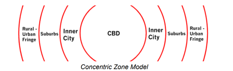
concentric zone model
core (oldest part of city CBD + earliest buildings)
inner city ring (early suburbs + old housing , non residential land use)
suburban ring (sururbs with housing as dominant land use)
urban urban fringe (countryside being ‘eroded’ by outwards spread of builtup area to provide new housing and some new non residential uses)
general age of builtup area decreases
style of architecture change
overall density of development changes
consequences of different land uses
1. People prefer to live close to those who they think are of the same status as them. So, people become segregated based on their:
a. social class
b. type of occupation
c. ethnicity.
2. However, wealth differences matter more.
a. The wealthiest buy large homes in the best locations.
b. The poorest have no choice but to live in cramped or substandard housing in the worst residential areas.
c. Many are unable to buy a home and instead rent. Due to their limited means, they are forced to occupy a small amount of space, and therefore have to live at high densities.
rural urban fringe/ urban fringe
areas where green fields and open spaces of the countryside meet the built up parts of the towns and cities
what spaces are found in the rural urban fringe
retail parks
more people own cars, large car parks are free, easy accessibility. city centre face traffic congestion and expensive parking
out-of-down centres have shopping malls that are bright and modern w everythingindustrial estates (following industries w a planned layout and road network)
light industries
service industriesbusiness parks
created by property developers to attract firms needing office accommodation. these include leisure activities such as bowling alleys, ice rinks, and cinemasscience parks
near unis or research centre to encourage high tech industrieshousing estates
group of houses built together often by gov. or private developer
greenfield site
undeveloped land that has never been built on
why are greenfield sites in demand
open land around edge of a city for housing, industry, shopping, recreattion etc.
a feeling of dissatisfaction with the city
housing is old, congested and not cheap
environmental pollusion
shortage of land for building new things, costly
land is cheaper, houses larger
facotories more spacious
closeness to main roads and motorways
favoured by peronal mobility allowed by car drivers
advantages and disadvantages of brownfield site
Reduces the loss of countryside and
land that might be put to agricultural
or recreational use.
Helps to revive old and disused
urban areas.
Services already in place.
Located near to main areas of
employment.
2. Often more expensive because old
buildings have to be cleared and
land made free of pollution.
● Often surrounded by rundown areas
so does not appeal to more wealthy
people as residential locations.
● Higher levels of pollution; less
healthy.
● May not have good access by road.
adv and disadv of greenfield
Relatively cheap and rates
of house building are faster.
● The layout is not hampered
by previous development so
can easily be made efficient
and pleasant.
● Healthier environment.
● Proximity of countryside,
leisure and recreation.
Valuable farmland,
recreational space and
attractive scenery lost.
● Development causes noise
and light pollution in the
surrounding countryside.
● Wildlife and their habitats
lost.
● Encourages further
suburban sprawl (spread of
urbanized areas into the
rural landscape).
Making urban living more sustainable may be achieved through a range of different activities:
● using renewable rather than non-renewable resources
● using energy more efficiently
● relying on public rather than private transport
● improving the physical infrastructure - clean water and proper sanitation
● improving social services and access to them
● improving the quality of life, particularly of the urban poor.