Coastal Landforms & Deserts
 Call Kai
 Learn
Learn Practice Test
 Spaced Repetition
 Match
Match Flashcards
 Knowt Play
1/130

There's no tags or description
Looks like no tags are added yet.
Name | Mastery | Learn | Test | Matching | Spaced | Call with Kai | Chat |
|---|
No analytics yet
Send a link to your students to track their progress
131 Terms
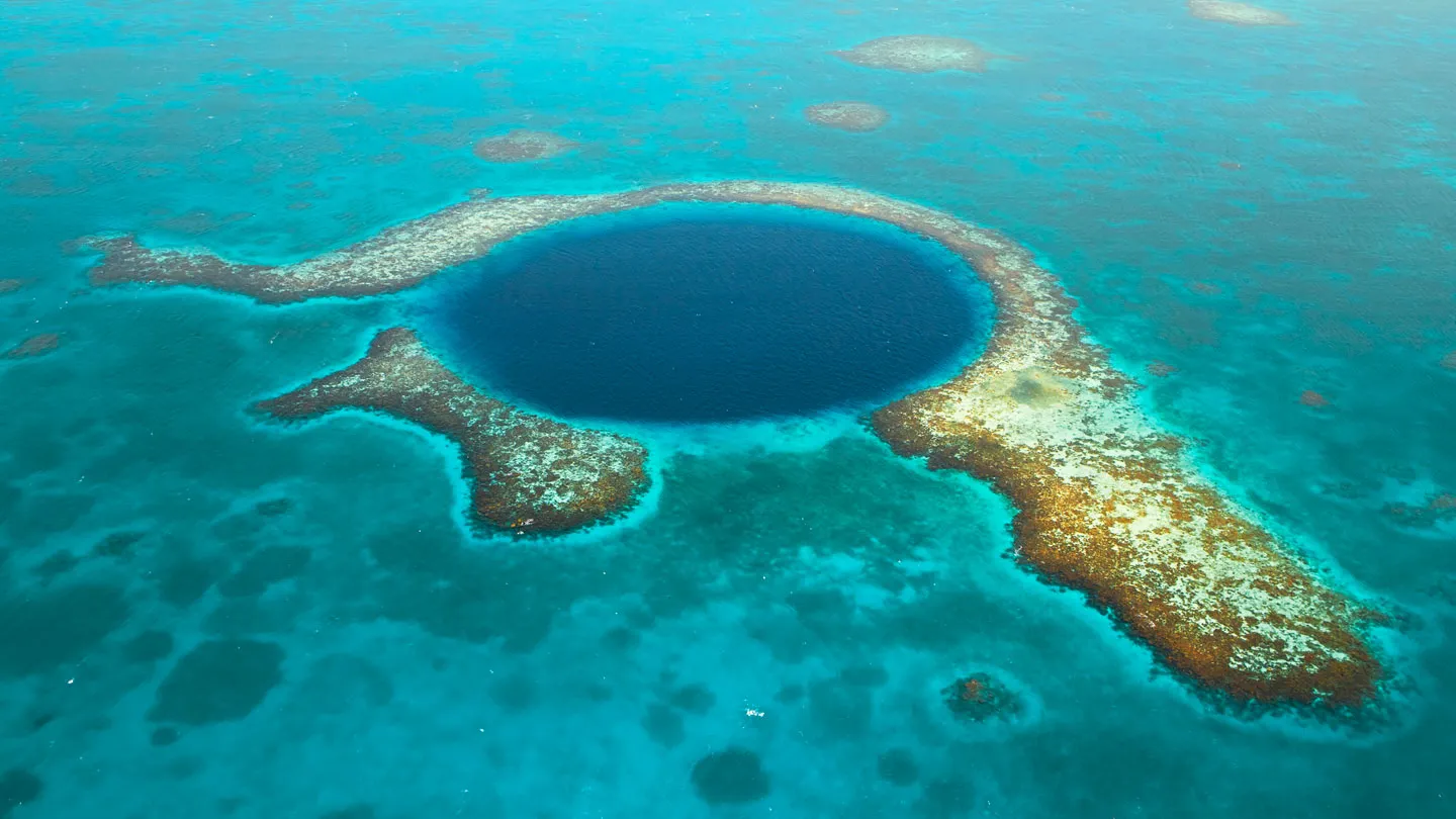
atoll (WOWOWWOWOWO)
pacific circular reef enclosing a lagoon
how are coastal landforms formed?
tides + ocean currents transport huge amounts of solid material that have been eroded from land
reg
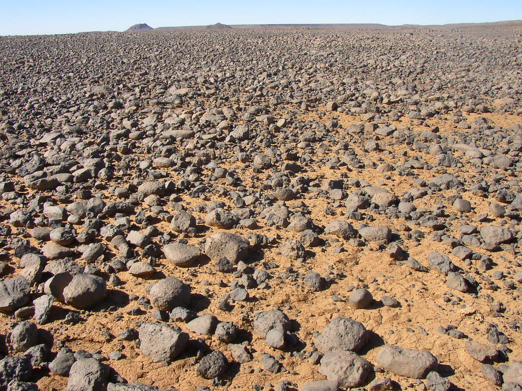
a hamada (desert pavement) that has a covering of pebbles + gravel on the top
→ lowkey just looks like a bunch of rocks on flat ground
what is a key feature when determining coastal features?
nature of the rock
→ e.g. hard rock resists erosion
wave action
slope of coast
change in sea lavel
coral formations
glaciers (fjords)
volcanic activity (determines rock type + mass wasting?)
human actions
what causes a wave to form
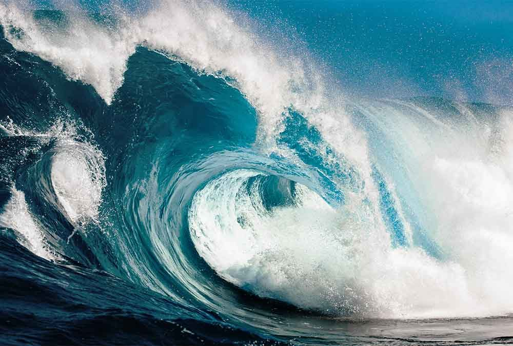
the wind blowing on the surface on the ocean
arches
formed by 2 caves on opposite sides of a headland
sea caves
formed by waves eroding a line of weakness along the headland
corrasive action + hydraulic action
opens up to form a large hole in the headland
offshore bar
a submarine bar built above surface of water
hinders commercial ships
made up of sand, gravel
formed by wave deposition in emergent coastlines
the more gradual slope allows waves to break far off from shore; thus sediment is deposited in the ocean before it hits the beach. over time, this builds an underwater ridge until it reaches the surface
raised beach
land that used to be below sea level (due to eustatic rise in sealevel after glacial retreat), and is now above the sea level (due to isostatic rebound)
lagoon
an enclosed “lake” of salt water
→ lies behind an offshore bar
shorelines of emergence
land is rising, water is becoming more shallow
significance of shorelines of emergence to humans
not good for deep harbours for ports
lots of sand bars inhibit commercial shipping
raised beaches + newly emerged coastal plains are good for agriculture or beaches
lagoons great for tourism & resorts!

what are these landforms? (1, 2, 3)
off-shore bar
lagoon
submarine bar
submarine bar
made up of sand, gravel
formed by wave deposition
ria coastline
a drowned, V-shaped valley
→ narrow, long, deep inlet
shoreline of submergence
land is sinking + water is rising
fjord coastline
a drowned U-shaped valley
→ narrow, long, deep inlet
eg. coast of BC or Norway
spit
a low, narrow ridge of sand or pebbles that is connected at one end to the land
occurs bc of longshore drift
may occur along bays or at the mouth of a river
become hooked over time if the waves come to the shore at an oblique angle
if this extends across the mouth of a river, the river either is diverted around this ridge or the river forms a lagoon

tombolo (image depicted is NOT geo, it’s a bolo bun)
a sandbar that connects an island to the mainland

bay mouth bar
spit that goes all the way across a bay
(we rhyming wow)
significance of submerged shorelines for humans
irregular coastline/features
hinders land transportation along the coast
deep harbours good for shipping + ports
rough terrain hinders human settlement
coral reef
occurs in warm tropical waters
living creatures produce exterior skeletons
skeleton is made of calcium carbonate
when these creatures die, the next generation can grow on top of the old skeletons
→ cycle of continual growth
these skeletons are a superb habitat to encourage biodiversity
give an example of a coral reef
The Great Barrier Reef of Australia
longitudinal coastline
folded mountains are parallel to the coastline

what type of coastline is this
longitudinal

what type of coastline is this
ria
bajada
coalesced alluvial fans at base of a mountain/mouth of a canyon
playa lake
small lakes underlain with alluvium & crusted with salts
usually formed at outer edge of an alluvial fan
the water runs past the alluvial fan to fill up a depression & create the lake
usually salty (brackish) water due to rapid evaporation in the desert
Note: a playa is a dry lake bed
why are alluvial fans often found in deserts
during flood stage, rivers in the desert are full of sediment & alluvium.
when this fast moving river suddenly moves from a steep mountain to a flat and open plain, it drops its load and creates an alluvial fan
a continuous group of merged alluvial fans is called a bajada
erg
an expanse of sand-dune topography
i.e. sandy parts of deserts
not all deserts are fully erg, bc some parts can have exposed bedrock bc the sand was stripped away by the wind
e.g. only 30% of Sahara Desert is covered with dunes (erg)
mesa
flat-topped elevated platform
has protective layer of limestone
separated from the main plateau (eroded remnant?)
butte
smaller isolated mesa
formed due to erosion
what is a desert
<250 mm annual precipitation per year
large difference btwn rate of evaporation and rate of precipitation
i.e. “the annual rainfall is not sufficient to maintain a continuous cover of vegetation” - Mleziva, Resource Binder
sandblasting or windblasting
when strong desert winds pick up tiny rock fragments and carrthem with great force, producing unique rock structures
aeolian transport
requires a lack of vegetation which usually:
restricts air movement
anchors the soil
effectiveness influenced by:
wind speed
hardness + quantity of sand
hardness of rock being eroded
dune synonym
drift
what is a dune
a pile of sand formed by an obstacle that blocks the wind
obstacle causes the accumulation of sand next to it
synonym for drift
barkhan/barchan
a crescent shaped dune
most common dune shape

why are some parts of the desert not covered with sand dunes?
wind action (aka aeolian erosion? aeolian transport??) can strip sand away from a large area along the desert.
→ this exposes the bedrock
→ creates hamadas
hamada
a large area of rough rock “pavement”
similar to reg but not entirely the same (regs have a layer of pebbles on top)
True or False: Deserts receive very little rain, but if it happens it is in the form of light showers
FALSE.
Although deserts rarely receive rain, when they do, it is often in the form of very strong torrents that produce thunderstorms + flash floods
lack of vegetation also increases the intensity of these flash floods bc there is no barrier to slow down runoff
lack of vegetation also causes the water rapidly flowing down desert slopes to tear large gashes
what is a drift
a pile of sand formed by an obstacle that blocks the wind
obstacle causes the accumulation of sand next to it
synonym for dune
wadis
wide, dry ditches
formed after rainstorm water evaporates
aka a wide, flat DRY river valley
only has water after infrequent storms

bajada
a continuous, broad, band of alluvium
formed from multiple alluvial fans merging into one
salt flat
a dried up playa lake
e.g. Salt Flats of Utah
bolson
a large desert basin that is slowly filling up with debris

plateau
a region that has a protective cap rock layer that prevents the rock underneath from being eroded by wind
eg. limestone, granite are both resistant to physical weathering!
canyon
deep river valley
formed by a large permanent river eroding through the protective cap of a plateau
lack of tributaries causes an absence of gullies/rills along the sides of the valley
eg. Grand Canyon, Colorado River
the bAdLaNdS
heavily eroded plateau after the protective limestone cap has been worn away
underlying layers are soft so highly susceptible to erosion
forms gullies, ridges, ravines, tall pillars of resistant rock
eroded by water in semi-arid climate
talus synonym + context in a desert?
scree
the rock fragments left at the base of a cliff
loess (desert context?)
wind-blown piles of finely-sorted rock sediment
mostly silt + clay
found on leeward/rainshadow side
e.g great loess deposits of Northern China + Argentina
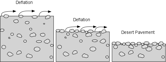
deflation
a gradual lowering of the land due to the removal of materials by wind in the desert
saltation (desert context?)
sands move by leaping and skipping across surface of sand, when pushed by the wind
surface creep
sands bump into one another, causing each other to move forward
analogous to attrition except the sands are not eroding each other, but merely moving each other
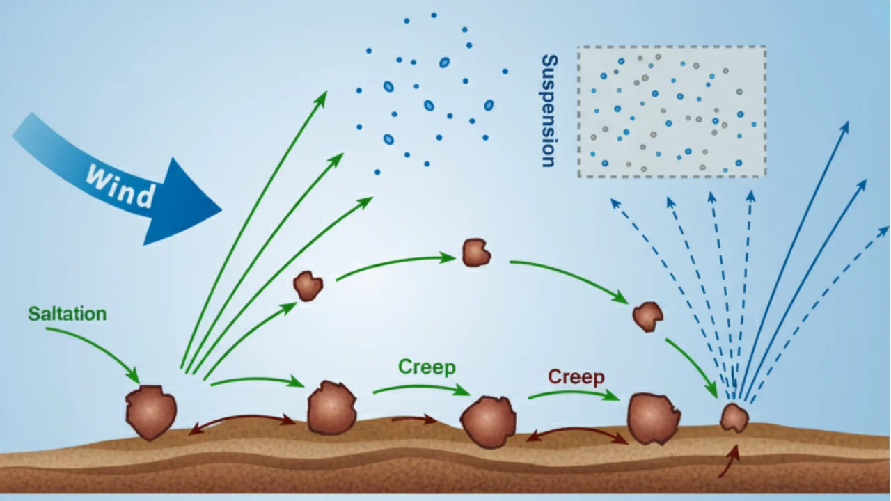
suspension (desert context)
so ppl know how most sediment is transported in the difficult climate of the desert
corrasion
dust particles or rocks hit each other to speed up process of erosion
exfoliation
needs large range of temperature
rapid fluctuations btwn day and night temps
minerals in separate layers expand at dif. rates → layers separate → layers peel off
stack
an isolated pillar of the cliff face that forms when an arch collapses
formed in hard rock
corrasion + hydraulic action
waves refract (bend) to target this protruding piece of rock → there so much more erosive power

define load and describe what it is composed of
the mix of materials carried by breaking waves on a beach.
sand
shingles
mud
what are the sources of load
rivers leading into the sea
wave erosion
mass wasting off of cliffs
undertow
an underwater current that pulls water from the shore back into the ocean
occurs during high tides to balance out the piling up of water
not the same as a rip tide bc its not as strong
not the same as a backwash bc its under the surface of the water

wave cut platform
the flat landform formed by deposits from the cliff face as it is undercut by the waves (thru attrition, abrasion, hydraulic action)
**note: if this land is uplifted, it creates a ______ ____ _________

wave refraction
when a wave approaches a headland that is protruding from the shoreline, the waves slow down and bend to concentrate around this point
occurs bc headlands have shallower water around them compared to the rest of the bay at that distance from the shore
waves slow down in shallow water + wave length shortens only in the area around the headland
the waves in the middle of the bay continue at the same speed as before → bending around headland

sheet flooding
occurs during heavy precipitation where the water covers the entire ground surface and flows as one body
carries a vast amount of sediment rapidly

pediments
a bedrock plain with little to no soil cover
starts at the base of steep mountains and gently slopes into the center of desert basins
formed by erosion

define coast
the piece of land before the highest water level
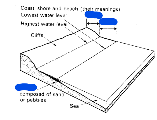
define shore
the region between the highest and lowest water level of waves

define beach
the assortment of sand & pebbles along a coastline that were deposited there by waves
top of wave
crest
bottom of wave
trough
what factors determine the power of a wave
fetch (distance of open water that the wind travels)
strength of wind (aka wind speed)
fetch
the distance of open water that a wind blows over to create a wave
bigger fetch = bigger waves
TRUE OR FALSE: Waves in the open sea are formed by currents of moving water
False.
Waves don’t actually move water - they move energy.
→ The water only actually moves forward when it crashes near land.
Currents do not form waves
→ the wind blowing across the water creates waves

This diagram depicts wind blowing over the surface of the sea, forming a wave. At which of the layers of air is friction the lowest?
the top layer has the lowest friction
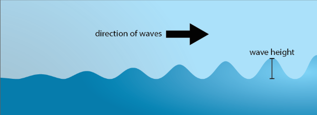
this wave is increasing in height. what does that say about the water depth at this location?
the water depth is getting shallower, thus:
the circular motion of the wave is flattened and slows down
waves behind this one catch up to the slowing wave and amplify its height
a taller wave is formed, which eventually falls forward on itself and crashes
what are 3 types of coastal erosion
attrition
hydraulic action
corrasion/abrasion
desricbe how hydraulic action erodes away at cliffs
the force of the water pushes into cracks in the cliff face
air inside these cracks is compressed
then, the water exits and the air rapidly expands from the decrease in pressure → shatters rock on cliff face
describe how attrition erodes away at cliffs
boulders and pebbles in the waves are dashed against each other + the beach.
this weathers them into finer particles
describe how corrasion/abrasion erodes away at cliffs
waves carrying pebbles, boulders, and sand slam into the cliff
these rocks undercut the cliff
destructive vs constructive waves
destructive:
backwash » swash
erosional
>9 waves/min
tall waves crash down on beach
steep, rocky beach
constructive:
swash » backwash
depositional
<=9 waves/min
short waves break on beach
gradually sloped sandy beach
groyne
perpendicular to coastline; blocks longshore drift
- must be able to tell which side wind came from by looking at distribution of sand btwn these sections
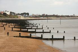
breakwater
parallel to coastline, in the water
→ blocks strong tides + protects moored boats behind it

seawall
reduces coastal erosion; parallel and adjacent to coastline
→ downsides: no beach


which direction is longshore drift moving in?
away from the camera
features common to submerging coastlines
drowned valleys
u-shaped = fjord
v-shaped = ria
headlands
bay beaches
stacks
caves
arches
spits (common to both)
features common to emerging coastlines
offshore bars (forms bc the beach gradient is so gradual that waves crash long before reaching the shore → sediment is deposited where the wave crashes)
lagoons
raised beaches
wave-cut platforms & terraces
spits (common to both)
mud flat vs salt flat
mud flat:
coastal feature
created in an enclosed or partially enclosed area of water
made of silt + clay
regularly flooded by ocean tides (so it has salt water)
eg. estuary of a ria or in a lagoon
salt flat (aka salt pan)
desert feature
formed by a dried out playa
leaves behind a flat, salt-encrusted layer
synonym for salt flat
salt pan

what is this
salt flat
bolson
the term for the entire desert basin that is slowly filling up with debris

wadis
a dried up desert valley; only has water during flash floods
hamada
aka reg
desert pavement
made up of large stones + boulders after all of the smaller pebbles have been blown away by the wind
(aeolian action)


what kind of weathering is this?
abrasion/corrasion
how to tell if smth if butte or mesa?
butte is taller than it is wide, mesa is wider than it is tall
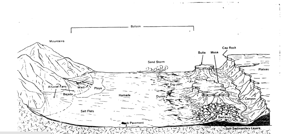
why are the badlands so easily eroded?
they don’t have a cap rock to protect the softer rock underneath
synonym for hamada
reg
canyon
a deep and wide river valley formed by a massive, permanent river cutting through the cap rock
sides are uneroded and relatively smooth due to lack of tributaries
deserts only have large rivers passing through bc of flash floods, no regular rainfall
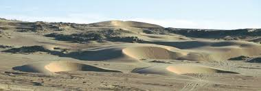
what direction is the wind originating from? thus, what would the name of this wind be if u name it according to the direction it came from?
explain which side of a barchan receives deposition, and which receives erosion, and why
the windward side receives erosion because the wind moves sand up the slope constantly
on the lee side, the wind slows down and drops/deposits some of its load because this side is slightly shielded from the wind. the horns are formed curved bc the wind moves sand faster at the edges where there is less sand.
TRUE OR FALSE: abrasion can refer to wind erosion
TRUE.
although wind is not the most powerful form of erosion in the desert, it can pick up sand and use the sand to erode at rocks.
eg. pedestal rocks
