geography - physical landscapes Paper 1
1/67
Earn XP
Description and Tags
yr 11 oct ->
Name | Mastery | Learn | Test | Matching | Spaced | Call with Kai |
|---|
No study sessions yet.
68 Terms
define upland
an area of high or hilly/mountainous land
low land define
an area that is low relative to its surrounding areas
landscape define
an extensive area of land regarded as being visually and physically distinctive
define coast
the boundary between the land and the sea
define swash
when water moves towards the beach
define backwash
when water moves away from the beach
wave formation
waves are caused by the transfer of energy ffrom the wind to the sea due to friction of the wind on the waters surface
the size and energy of a wave is influenced by (3)
how long the wind has been blowing
the strength of the wind
the fetch
define fetch
how far the wave has travelled
types of waves (2)
constructive waves
destructive waves
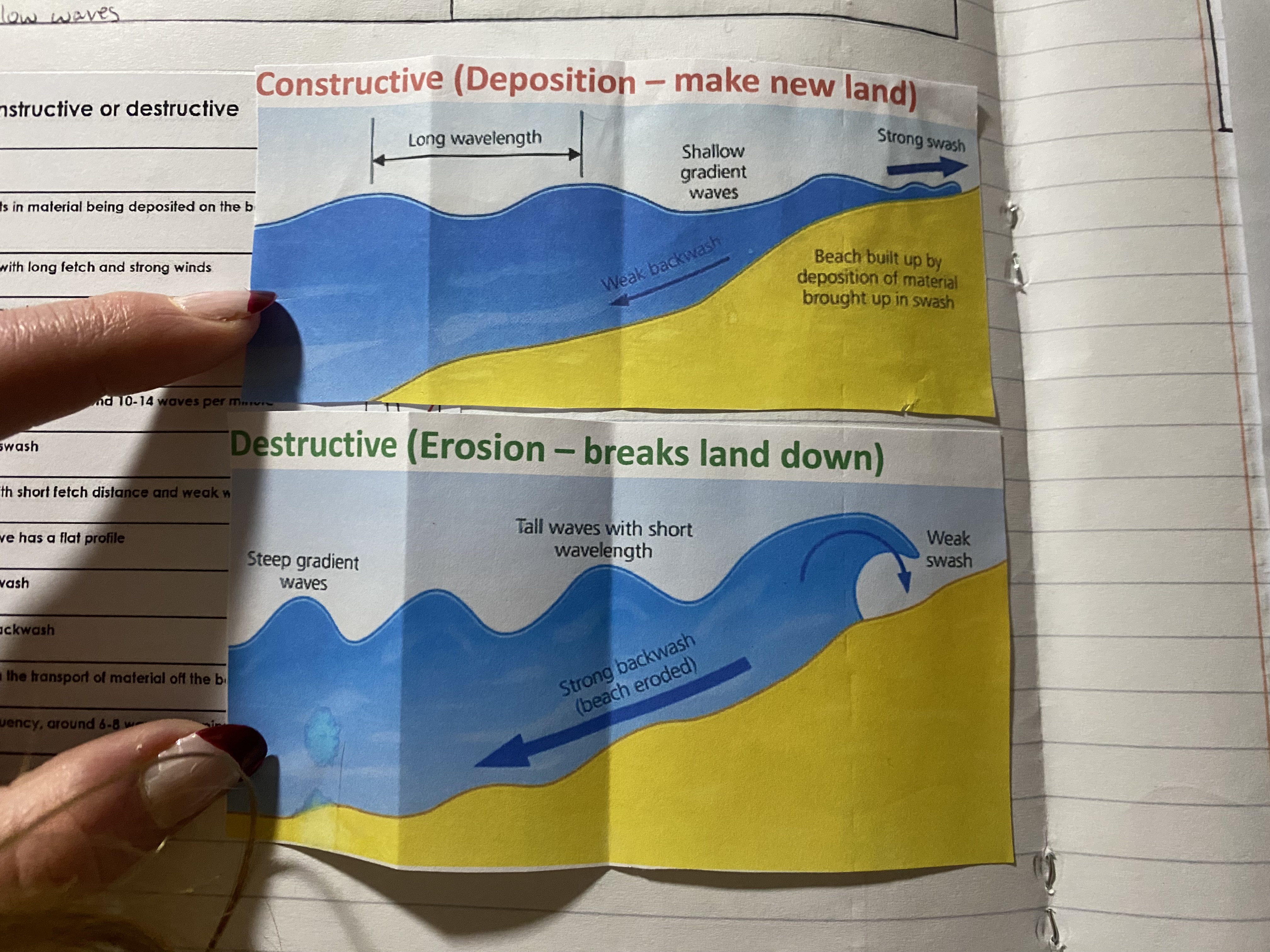
the difference between constructive and destructive waves
constructive (deposition - makes new land) destructive (erosion - break land down)
-constructive waves have a:
-weaker back wash - beach isnt eroded
-beach IS built up by material brought up in swash vs a weaker swash
-stronger swash
-longer wavelengthes
-shallower waves
-lower frequency
-
whats the top of the wave called
whats the bottom of the wave called
top = crest
bottom = trough
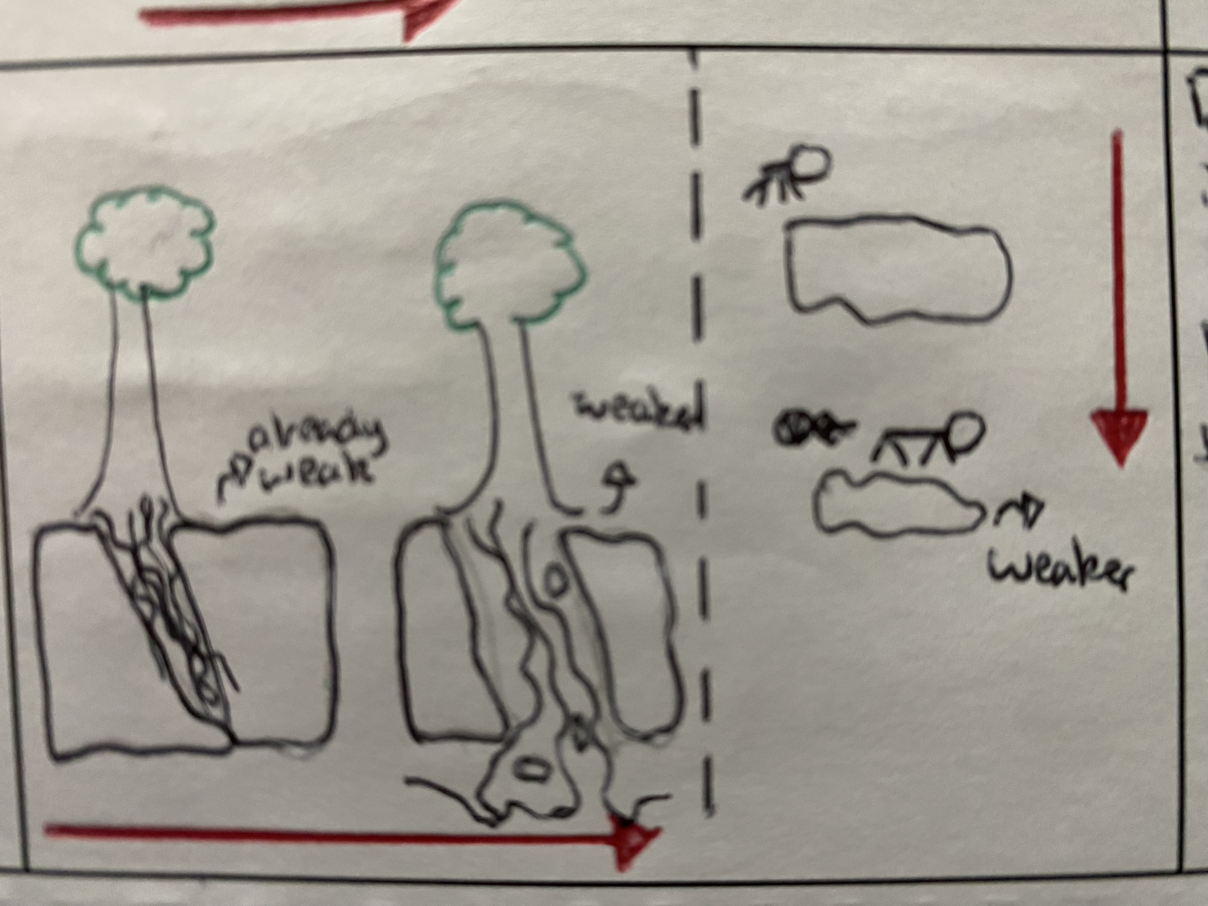
define weathering
the breakdown of rocks by physical actions at the top of the cliff e.g. rain,snow, or cold
difference between weathering and erosion (2)
weathering involves no moment - erosion does
occurs at top of the cliff - erosion occurs at the base of the cliff in association with the sea often
physical weathering
diagram + how it works
where water gets into the cracks in the rock. changes in temp cause the water to freeze. when water freezes it expands and makes the cracks bigger. The ice then melts, this process will repeat many times
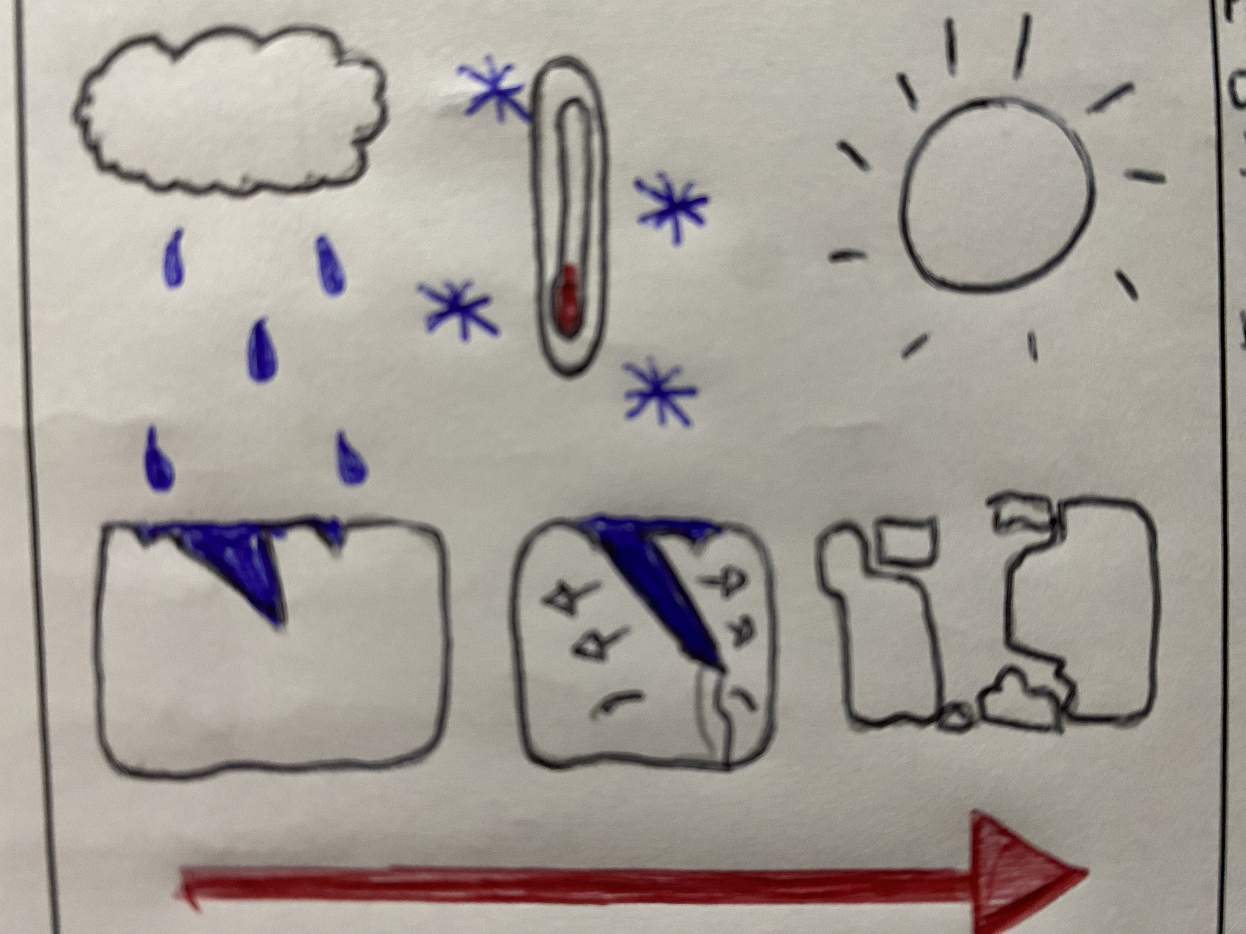
chemical weathering
is where chemicals react with the rocks. Oxidation is one type of chemical weathering, it causes rust. Acid rain causes limestone to disintergrate and become weaker. This is when water and carbon mix together

biological weathering
is where vegetation roots grow into cracks in the rock. this then prises the crack to open. this can also happen with animals that burrow into rock (e.g. rabbit). Both of these weaken the rock
define mass movement
the downhill movement of soil and rock on a slope, primarily driven by gravity
what are the different types of mass movement
slides
slumps (most likely to be asked about in exam)
rock falls
mass movement
slides
material shifts in a straight line along a slide plane
often occur on cliffs made of resistant rock e.g. sandstone
ususally triggered by erosion or heavy rainfall
happens by:
-marrine erosion - forms a wave-cut notch, removing support
-rain water infiltrates the rock adding weight + reducing internal cohesion
mass movement
slides
material rotates along a curved slip plane
often occurs when cliffs are made of soft materials e.g. boulder clay
top looks the same, just dropped slightly
has 2 different types of material soil + clay
happens by:
-rainwater infiltrates + saturates the clay (weight inc)
-waves erode base of cliff through hydraullic action + abrasion, forming a wave-cut notch
mass movement
rock falls
material breaks up, often along bedding planes and falls down a slope
common on steep/verticle clkiffs, composed of hard. jointed rock e.g limestone
happens by:
-weathering processes, esp freeze-thaw, widen joints + cracks in the rock
coastal processes (3)
erosion
transportation
deposition
same for coasts and rivers
define erosion
the wearing away and removal of material by a moving force such as a breaking wave
types of erosion
hydraulic action
define + picture
this is the force of water hitting the cliff and squeezing air into the cracks in the rock
types of erosion
abrasion
define + picture
the force of the sand and pebbles carried in the water blasting into the cliff
types of erosion
attrition
define + picture
this is the process of rocks hitting each other and breaking into smaller rocks
types of erosion
solution
define + picture
a chemical reaction between the sea water and the minerals
why do some coasts erode more than others (6)
large fetch
no beach (takes impact of the waves)
strong winds (cause destructive waves)
cracks in rock (more prone to erosion - is weaker)
rock is less resistant (weaker)
waves refract and hit the sides
define transportation
the movement of sediment (sand) along a coastal region
types of transportation from biggest → smallest
traction
saltation
suspension
solution
transportation
traction
define + picture
pebbles and larger sediment are rolled along the sea bed
transportation
saltation
define + picture
load is bounced along the sea bed e.g. small piceces of shingle or large sand grains. Currents cannot keep the larger and heavier sediment afloat for long periods
transportation
suspension
define + picture
small particles are carried in the water e.g. silts and clays which can make the water look cloudy. Currents pick up large amounts of sediment in suspension during a storm, when strong winds generate high energy waves
transportation
solution
define + picture
minerals are dissolved in sea water and carried in solution. load is not visible. load can come from cliffs made from chalk or limestone, and calcium carbonate is carried along in solution
longshore drift diagram
define deposition
the ‘dropping off’ of sediment →has to have sand for deposition
do waves have high or low energy
low
define bay
acresent shaped indentation in the coastline between two headlands - made of softer (less resistant) rock that erodes quicker
define headland
a cliff that juts out into the sea - and so is surrounded by water on all 3 sides - made of harder rock that erodes slower
discordant coastline
the different types of geology run at right angles to the coast
define concordant coastline
the different types of geology run at parallel to the coast
how are headlands and bays formed
when more and less resistant rock lie next to each other on a discordant coastline. the waves pound against the rock and erode it away. The soft clay will erode more quickly forming a bay whereas the hard chalk will erode more slowly, causing a headland to form
headland formation - errosional land form - formation of caves, arches and stacks
a large crack is enlarged by the pressuure on/off effect of hydraulic action
the crack grows into a notch and then a cave as destructive waves converge on the headland and continue to erode it
overtime, the cave becomes larger, wavere fraction draws waves to all sides of the headland so caves may form back to back
the sea breakes through the back of the caves forming a natural arch. the base of the arch is widened as notches form from hydraulic action + abrasion
weathering è.g freeze thaw continues to weaken the top of the arch, making it less stable
the top of the arch eventually collapses
this leaves a pillar of detached rock called a stack
notches at the base of the stack which eventually makes it unstable
the stack will eventually topple into the sea leaving only its base this stump is normally only visible at low tide
cliff characteristics
the shape of cliffs depend on the rate at which they erode
the rate at which a cliff recedes depends on the resistance (hardness) of the rocks
-e.g.- more resistant (hard) granite cliffs at Lands end (cornwall) retreat at a 0.001 metre annually and will be really tall and steep
soft boulder clay at happisburgh (norfolk) have a 5 metre anual rate of
cliff retreat and wave cut platform diagram and formation
marine erosion (hydraulic action) undercuts and erodes the base between the high tide and the low tide
over time at wave-cut notch is formed from the constant erosion at the base of the cliff
an overhang is visible over the top of the wave-cut notch
weathering e.g. freeze thaw attacks the overhang making it weaker and more vulnerable and the wavect notch is enlarged due to erosion
the wavecut notch is enlarged further that the overhang starts to collapse on the beach below. a steep cliff is now created
the process repeats and cliff continues to retreat. the old base of the cliff is left as wave-cut-platform
characteristics of a wave cut platform
smooth bare rock
deep cracks
barnacles clinging to the rock (seaweed thrown through rough seas)
low tide
gentle slopes
covered at high tide and exposed at low tide
pitted appearence (bare rock with rock pools)
define depositional
sand being ‘dropped off’
define beach
a landform of coastal deposition that lies between high tide and low tide levels
beach profile DIAGRAM
a)dunes or storm beach
b) backshore(not usually affected by waves so usually dry)
c) foreshore (inter-tidal zone that is repeatedly covered then uncovered by changing tides
d) near shore (where waves break)
e) offshore (waves not breaking)
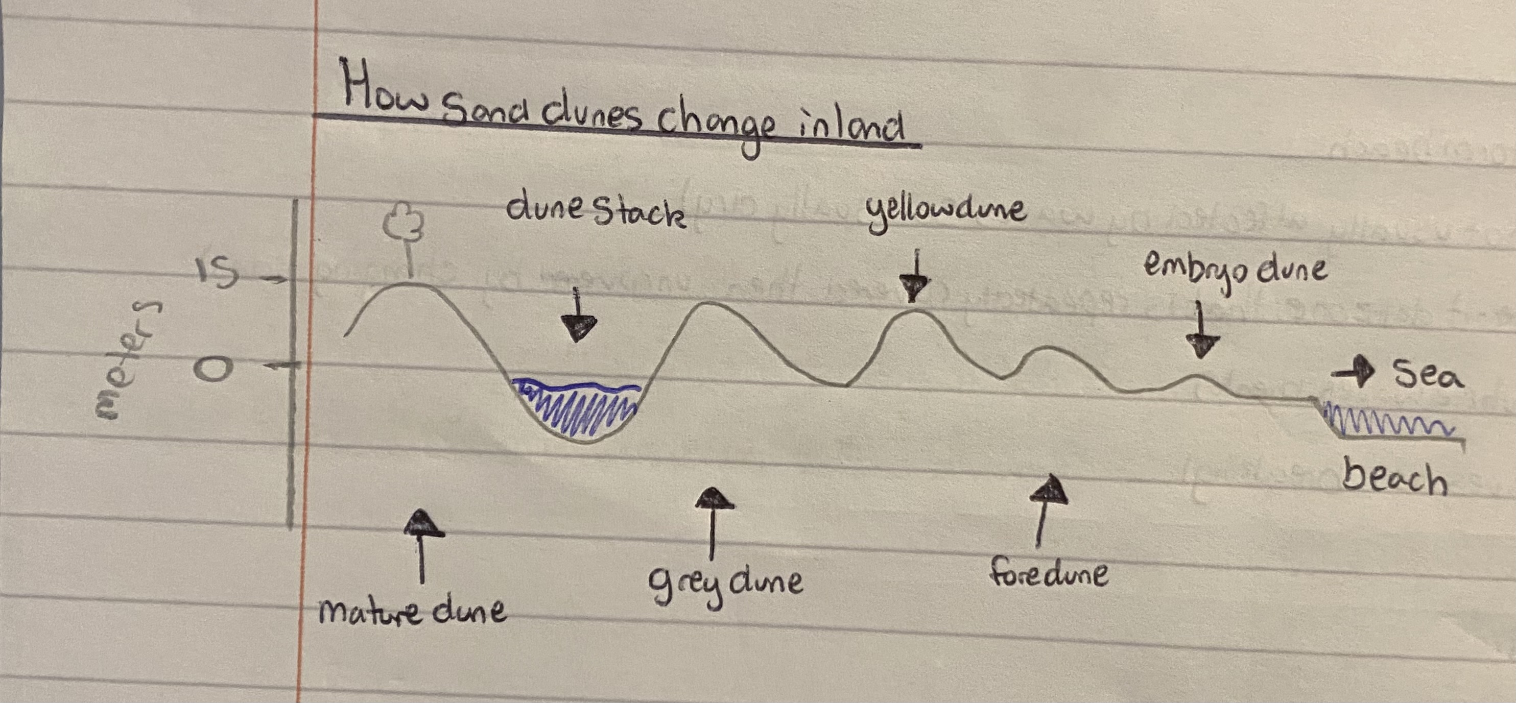
sand dunes
where do they start
what is deposited on the beach + where
name of first sand dune formed
word describes what the plants will do to the embryo sand dune over time
what example is given of a pioneer species
what happens to the embryo dune over time/what does it turn into
what has happened for this second dune to form
what has also formed in front
what will happen to the embryo dune
what other examples of pioneer species are there
what will make the sand dunes stable
how lonng does this process take
where there is lots of sand
seaweed - or some other kind of barrier thats holding the sand back
embryo dune
colonise
marram grass
gets bigger and becomes more stable
has been stabilised
another sand dune
it will become more stabilised and another will form in front
sea lime and sand sage - has to be plants that can withstand wind + salty water
vegetatio
up to 400 years
how sand dunes change in land DIAGRAMS
define spit
a sand or shingle beach that is joined to the land but projects into the sea (like a finger)
features of a spit
prevailing wind direction
direction of longshore drift
salt marsh and mudflats develop
original coastline
strong river current stops spits extending further
secondary wind causes end of spit to curve
river mouth or estuary
how are spits formed
spits are formed where the shape of the land changes direction. The prevailing wind causes long shore drift . Swash of the waves will come in at an angle and the backwash will go back at 90 degrees. This means the sand is transported along the coast and deposited in the sea. This makes the spit which will have a curved end
e.g. Sandbanks spit, in poole, dorset isn’t growing due to tidal currents and dredging
define bar
a ridge of sand or shingle that stretches from one side of a bay to the other, forming a lagoon behind it
lagoon is a lake but with sea water - part of the ocean (lakes are fresh water
how are bars formed
hard engineering define
builing strong barriers with concrete steel and or rocks. The main aim is to stop the waves eroding the coast. Man made. Materials are more expensive and last longer
soft engineering define
methods aim to work more in harmony with nature than the large man made hard engineering structures. Is still man made. Cheaper but doesnt last as long
e.g. adding more sand to the beach
coastal management - soft engineering
beach nourishment
description, picture, advantage, disadvantage, cost
replaces sand and shingle, which has been lost from the beach. absorbs energy and is good defence against the sea. It protects land or sea wall behind the beach and looks more natural
looks natural and can provide people with an area for recreation as people can play on the new formed beach
less expensive than most hard engineering methods
-needs to be done regularly as beach is washed away
-hard to find same type of sand/shingle as before
cost=£2 mill per km
coastal management - soft engineering
dune regeneration
description, picture, advantage, disadvantage,cost
artificially creating new sand dunes along the coastline to act asa buffer between the land and the sea. Sand dunes are under threat because they are fragile and people walk all over them and destroy the dune ecosystem
relatively low cost and provides a natural appearance with limited visual impact. Helps to maintain the ecosystem
-need regular maintanence, they are less likely to be effective against extreme storm events
-less time consuming to plant marram grass + fence off areas
cost=£2000 per 100m
coastal management - soft engineering
managed retreat
description, picture, advantage, disadvantage,cost
areas of coast are allowed to erode and flood naturally. ususally this will be areas considered to be of low value
encorages the development of beaches (natural defense) and salt marshes (important for environment)
low cost
-is low cost but not be free as ppl will need to be compensated for loss of buildings and farmland
cost=depends on stretch of coastline that is letting erode. Undeveloped coastline will be cheaper than developed stretch of coastline
coastal management - soft engineering
marsh creation
description, picture, advantage, disadvantage,cost
allowing the sea to flood and spread over a large area - creating a salt marsh
new habitats are created
reduses risk of flooding along the coast
low cost
-ppl/ businesses may need to move away from land that is going to be flooded
-value of land will be lost
coastal management - hard engineering
groynes
description, picture, advantage, disadvantage,cost
built down the beach and into the sea about 200m apart. They slow the movement of material along the coast and help build up the beach
stops the transport of material away from the area you are trying to protect which leads to a beach then helps to protect the land
-may cause erosion on other areas of the coastline as there is no longer a beach there to protect it
-costly to build and maintain
-ugly
cost = £1.5 mil each region
coastal management - hard engineering
sea wall
description, picture, advantage, disadvantage,cost
stops waves reaching the land. they reflect the waves back to the sea, but this can wash away the beach. They give good protection but are expensive and may need to be repaired in time
protects base of cliff from erosion and can prevent coastal flooding of the same area. the land and buildings around the cliff are protected from erosion
-sea walls are very expensive to build and they need regular maintanance (expensive)
-sea walls often reflect back into the seawhhich leads to inc erosion of the beach
cost=£7mil per km on av
coastal management - hard engineering
rock armour / riprap
description, picture, advantage, disadvantage,cost
mixture of large boulders and concrete blockas which protect the coast by breaking up the waves
helps retain the beach. they absorb the wave enrgy so the waves no longer have the enrgy to erode the cliff or beach
-dont protect the cliffs as much as other types of coastal protection
-initial cost of transporting the boulder and concrete blocks is large
cost=£3mill per km on av
coastal management - hard engineering
gabions
description, picture, advantage, disadvantage,cost
a cage, cylinder or box filled with rocks, concrete or sometimes sand and soil for use in civil engineering, road building, military applications and landscaping. for erosion control, caged riprap is used
relatively cheap
quick solution
last 20-25 years
-can only be used on sandy beaches
-easy worn away - need to be maintained - can be dangerous if they are damaged
-can be unsightly
-birds can get their feet caught in them
cost=£110 per metre
coastal realignment define
allowing area to flood and erode so habitats can thrive and through natural processes the shoreline is reshaped. This is a type of soft engineering that is very sustainable and long term