Global Hazards
1/84
There's no tags or description
Looks like no tags are added yet.
Name | Mastery | Learn | Test | Matching | Spaced |
|---|
No study sessions yet.
85 Terms
What does the structure of the Earth consist of?
The inner core
The outer core
The mantle
The crust
The inner core
centre of the earth
hottest part
solid metal ball - made of iron and nickel
diameter of 2440km
temperatures up to 5,500 °C
energy created by radioactive decay
The outer core
layer surrounding the inner core
2300km thick
liquid layer, also made from iron and nickel
temperature ranges between 4000-5000°C
The mantle
thickest section of the Earth - 2900km thick
temperatures range between 500-900°C
the mantle closest to crust is made of semi-molten rock (asthenosphere)
the mantle nearest to core is completely molten (magma)
The crust
outer layer of the earth
thin layer between 0-60km thick
crust is the solid rock layer we live on
either continental or oceanic
Continental crust
has land on it
can’t sink
made of basalt igneous rock
20-200km thick
less dense than oceanic crust
cannot be destroyed
3.8 billion years older than oceanic crust
Oceanic crust
average thickness of 5-10km thick
denser than continental crust
composed of basalt
less than 200 million years old
What mechanisms are believed to to move tectonic plates?
slab pull
ridge push
Slab pull
occurs where older, denser tectonic plates sink into the mantle at subduction zones. As these older sections of plates sink, newer and less dense sections of plate are pulled along behind. Sinking in one place leads to plates moving apart in other places.
Ridge push
where the new crust formed at divergent plate margins is less dense than the surrounding crust and so it rises to form oceanic ridges. The older seafloor either side of the ridge slides away and this moves the seafloor apart – moving the tectonic plates.
The theory of plate tectonics
the movement of the plates and the activity inside the Earth
How do plates move by convection currents
heat from the core makes magma in the mantle rise towards the crust
as the hot current nears there crust, it begins to cool and sink back towards the core
as the magma sinks, it drags the plates across the surface of the Earth
What is the point where two plates meet called?
plate boundary
How are constructive plate boundaries (margins) formed?
where convection currents move plates apart
How are destructive plate boundaries (margins) formed?
where convection currents push plates together
Where are earthquakes and volcanoes most likely to occur?
either on or near plate boundaries
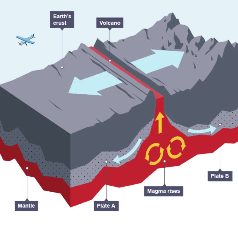
Constructive plate margin
most are found on ocean floors
as the plates slowly move apart magma rises from the mantle to fill the gap (accompanied by earthquakes)
when the magma reaches the surface it cools and solidifies to form a new crust of igneous rock
mid-ocean ridges will be formed at constructive plate boundaries
Mid-ocean ridge
an underwater mountain chain of volcanoes built up after repeated eruptions at a constructive boundary, when the sea floor spreads apart
e.g. the Mid-Atlantic Ridge
some of these undersea volcanoes become so large that they erupt out of the sea to form volcanic islands, e,g. Surtsey and the Westman Islands
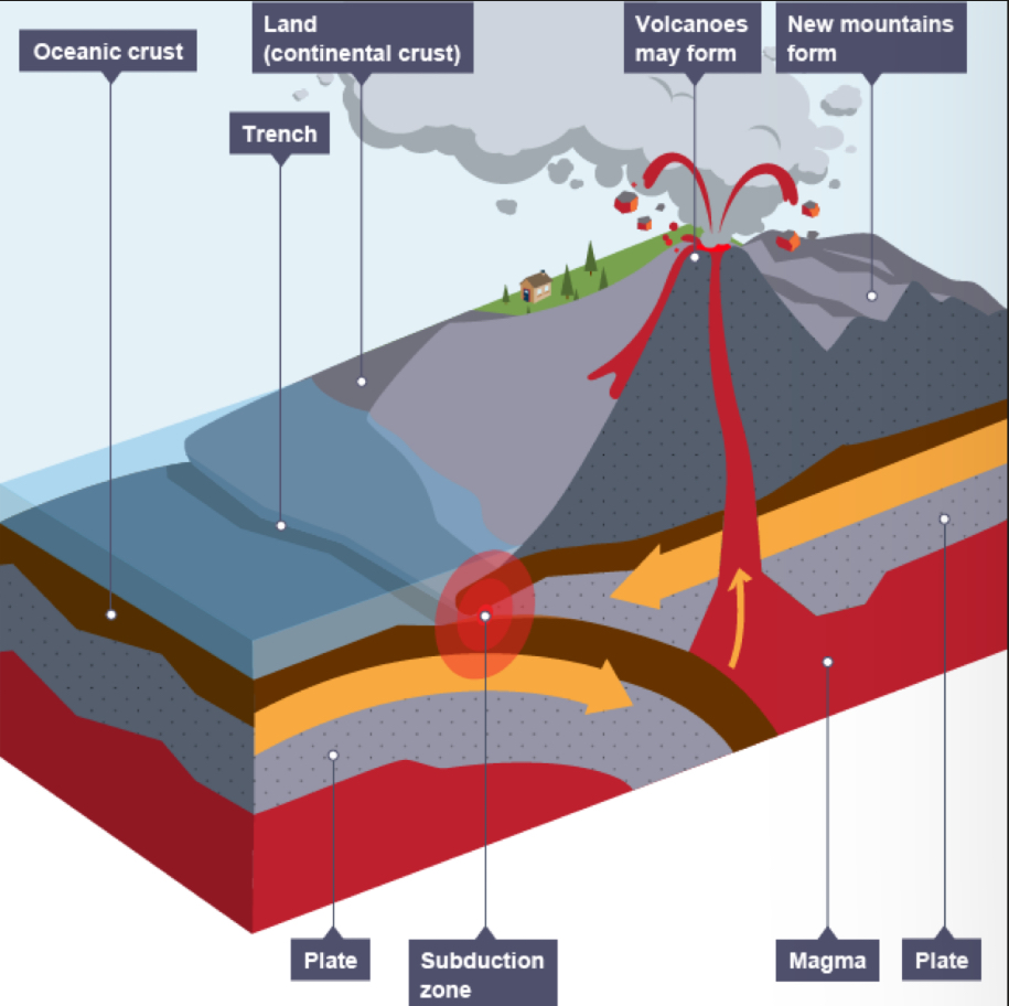
Destructive plate margin
subduction zones and ocean trenches will be formed here
the plates move towards each other here, usually a continental plate and an oceanic plate
when the oceanic plate is forced below the continental plate it melts to form magma and earthquakes are triggered
the plate melts due to friction and heat from the mantle
the magma collects to form a magma chamber
this magma then rises up through the cracks in the continental crust
as pressure builds up, a volcanic eruption may occur causing composite cone volcanoes (e.g. Nevado del Ruiz in Colombia)
a major example of this plate movement is along the coastline of South America (at the Nazca and South American plate boundary)
fold mountains, such as the Andes are found at destructive plate boundaries
they are formed due to the pressure of the two plates colliding, which forces the continental crust to crumple and push upwards along the western coastline of South America
subduction zones
the oceanic plate is denser than the continental plate, so as they move together the oceanic plate is forced underneath the continental plate, the point where this happens is called the subduction zone
ocean trench
at the point where the plate is forced down, there will be a deep gap under the sea (an ocean trench)
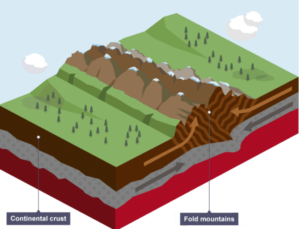
Collision zones
Collision zones form when two continental plates move towards each other and collide. The land between the plates is forced upwards to form fold mountains, eg The Alps and Himalayas.
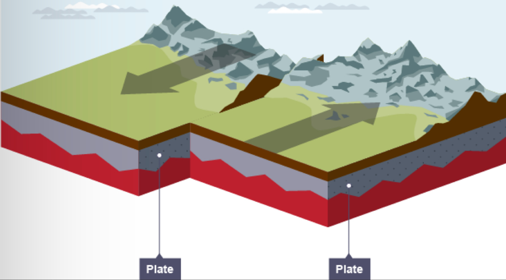
Conservative plate margin
At a conservative plate margin the plates are moving past each other or move side by side at different speeds, like cars on a road.
As the plates move, friction occurs and they become stuck. The plates are still trying to move so pressures and stresses build up in the crust. When the pressure is released suddenly, waves of energy move through the crust, causing an earthquake.
The earthquakes at a conservative plate margin can be very destructive as the focus is close to the Earth's surface. There are no volcanoes at a conservative plate margin.
Where are earthquakes found?
they are found along all types of plate margins
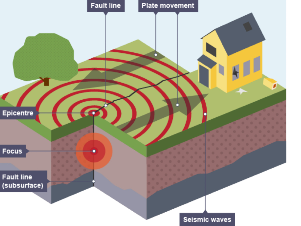
What is the focus of an earthquake?
the actual place in the crust where an earthquake is created
earthquakes caused at plate margins can have either a deep-focus or shallow-focus
Shallow-focus earthquakes
more destructive because they make the ground shake more at the surface
e.g. the 2021 Haitian earthquakes’s focus depth was only 10km, but it measured 7.2 on the Richter scale and caused tremendous damage
Deep-focus earthquakes
less destructive as the focus is deeper
e.g. the 2022 Peruvian earthquake, at a depth of 217.8km measured 7.2 on the Richter scale but was not intense at the surface
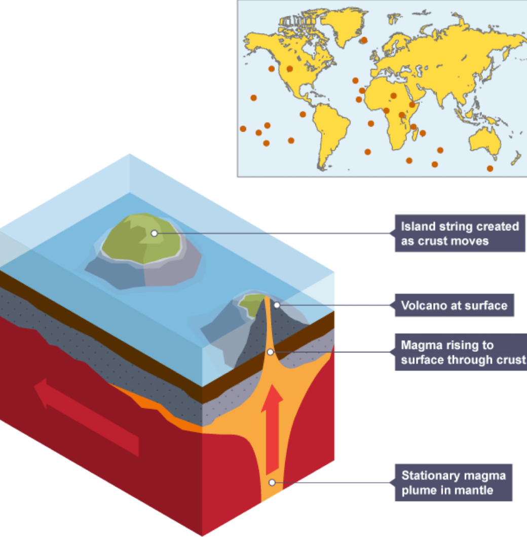
Hotspots
stationary magma plumes deep in the Earth that create volcanoes on the surface (e.g. Mount Kilauea in Hawaii)
magma comes to surface through cracks in the rocks with great heat and low pressure
hotspots can be linked to plate margins or may just form on a crustal plate
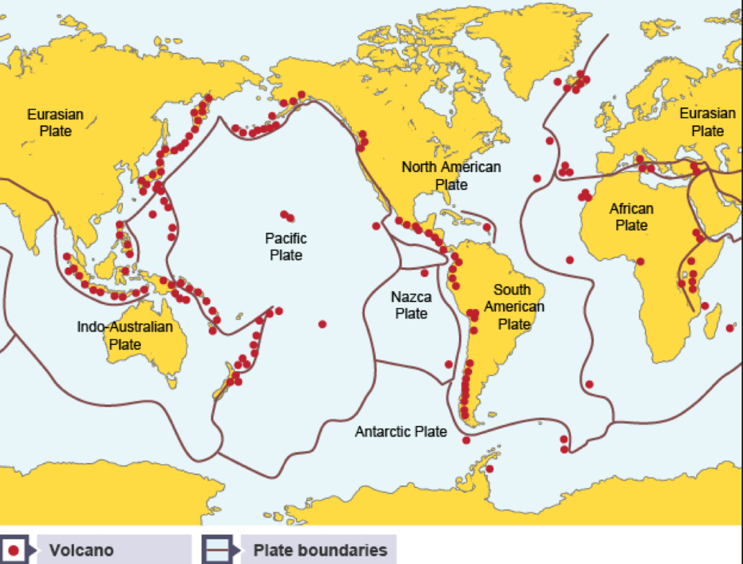
Where do volcanoes only occur?
at constructive and destructive plate margins and hotspots
the ‘Ring of Fire’ is a very active collection of volcanoes along the plate margin that surrounds the Pacific Ocean
How do earthquakes happen
when plates try to move but become stuck together due to friction
pressure builds up because the plates are still trying to move
when the pressure is released suddenly, huge amounts of energy are released causing earthquakes
the point inside the Earth’s crust where the earthquake begins is called the cous
the earthquake’s energy is released in seismic waves which spread out in all directions from the focus
Which waves move the ground up and down?
primary or longitudinal waves
Which waves cause side to side movement?
secondary or transverse waves
Where are seismic waves most powerful?
the epicentre
Epicentre
the point on the Earth’s surface directly above the focus. The focus can be shallow or deep inside the crust.
the shallower the focus the stronger the earthquake effects will be at the surface
Richter scale
measures the magnitude of an earthquake
measured using a machine called a seismometer, which produces a seismograph
numbered 1-10, logarithmic scale
earthquakes measuring 1-2 a minor
earthquakes measuring upwards of 7 are less frequent but very powerful and can cause a lot of destruction
What are the impacts of an earthquake dependent on?
strength on Richter scale
level of development in country - richer countries are more likely to be able to predict, protect and prepare for the impacts of an earthquake
the depth of focus - if its shallow impacts will be more destructive
distance from epicentre - effects are most severe nearest to its epicentre
population density - the more people living in an area, the more likely it is that deaths/casualties will occur
time of day - if people are in their homes, at work or travelling, earthquake impacts are worse
Short-term responses to an earthquake
a response in the days and weeks immediately after a disaster has happened
mainly involve search and rescue and helping the injured with medical aid, providing emergency shelter, food and water
Long-term responses to an earthquake
responses that go on for months and years after a disaster
they involve rebuilding destroyed infrastructure, e.g. roads, houses, power and water supplies, schools and hospitals
they also involve ‘kick-starting’ the local economy
How do volcanoes form?
when magma (molten rock from the mantle) reaches the Earth’s surface
the magma erupts to form lava at the surface, either on land or under the sea
Where do volcanoes usually form?
along plate margins, where crustal plates are either moving towards or away from one another
Constructive margin
this is where two plates move away from one another
magma rises to fill the gap between
Destructive margin
this is where two plates move towards one another
heavy oceanic crust sinks beneath the continental crust at a subduction zone
as oceanic crust sinks into the mantle, it melts into magma, which rises to the Earth’s surface to form an explosive volcanoe
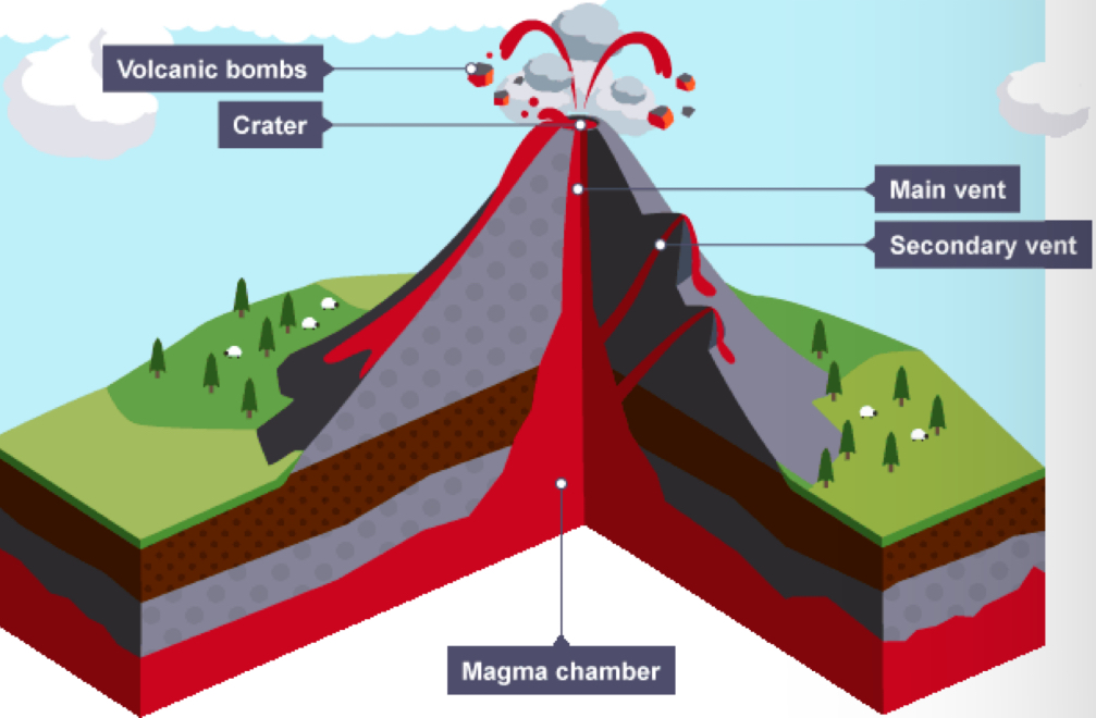
Shared features of composite and shield volcanoes?
magma chamber - where molten rock is stored beneath the ground at great heat and pressure
main vent - this is the channel through which magma rises to reach the Earth’s surface
secondary vent - some magma may escape through the side of the volcano, particularly if the main vent becomes blocked
crater - this is found at the top of the volcano and the magma usually erupts from here
cone - this is formed from the material ejected during eruptions and grows in size with each eruption
Pyroclastic flow
deadly mixture of hot steam, ash, rock and dust
moves at very high speeds and has high temperatures (400°C)
Composite volcanoes
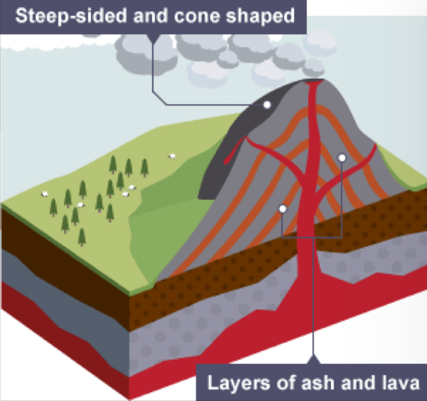
made of alternating layers of lava and ash
found at destructive margins
eruptions were infrequent, but mostly violent and can include volcanic bombs
the eruptions from these volcanoes could be pyroclastic flow
they are steep-sided as the thick and heavy lava doesn’t flow very far before it cools
examples of this type are Mt Unzen on Kyushu, Japan and Mt Etna in Sicily, Italy
Shield volcanoes
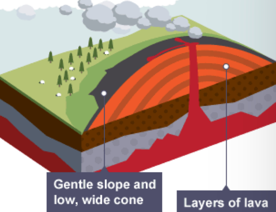
found at constructive margins or over a hotspot
they have gently sloping sides because the lava is this and runny so it moves far before it solidifies
eruptions tend to be often or continuous and mostly gentle
an example of a shield volcanoe is Kilauea, in Hawaii
Hotspots
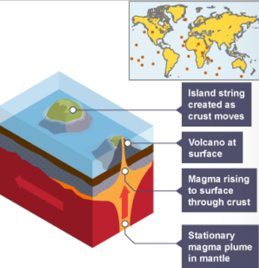
places where the magma rises up through the crust
they are caused by a static source of magma, often away from plate margins
as the plate moves away from the hotspot, a new volcano island will form
Negative consequences of volcanoes
produce ash, lava, volcanic bombs, pyroclastic flows and lahars which all greatly alter the landscape
ash from large volcanoes has been known to affect global weather climates
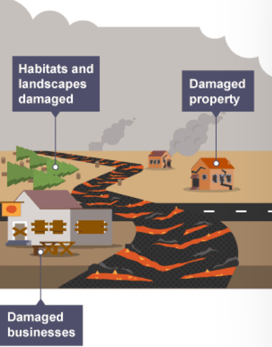
dangerous - can kill people and damage property and services
economic activity can suffer as it is hard for businesses to operate and recover after an eruption
natural habitats are disrupted and animals and plants are destroyed
Positive consequences of volcanoes
Volcanoes serve as tourist attractions, bringing in money for the local economy.
Volcanic ash acts as a natural fertiliser for the soil, which is good for growing crops.
Geothermal energy can be generated in places where the crust is thinner and so volcanic areas can be used to harness renewable energy.
Popular techniques for monitoring volcanoes
seismometers - measure the seismic waves occurring before and during an eruption
tiltmeters, GPS satellites and lasers - monitor any changes in landscape, since volcanoes tend to swell near an eruption
'spider' robots - monitor gases escaping from a volcano, as there is often an increased release of sulphur dioxide near an eruption
thermometers - measure temperature as volcanoes become hotter when magma starts to rise through the main vent
chemical analysis of water in local rivers and lakes near volcanoes - as volcanoes release minerals which seep into the surface and ground water before and during an eruption
data analysis - by looking at the past history of eruptions to identify patterns of activity
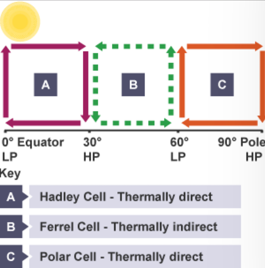
Global atmospheric circulation
Solar energy enters the atmosphere. Equatorial regions get the most.
There is more energy at the tropics than at the poles, creating an imbalance.
As warm air rises and cold air sinks it forms three atmospheric circulation cells north of the equator and three to the south.
These circulation cells move over land and sea to redistribute the energy, from the equator to the poles in both hemispheres, trying to even out the energy imbalance.
Hadley cells (0-30° latitude)
Solar heating at the equator warms the air above.
The air rises and expands creating low pressure.
The air travels to around 30°, cooling as it moves.
At around 30° the cooled air sinks back to Earth to create an area of high pressure.
Air moves from this high-pressure area to the equatorial low-pressure area.
This is a thermally direct cell.
Polar cells (60-90° latitude)
The air above the poles is cold.
The cold air sinks creating high pressure.
The air moves towards the equatorial low-pressure zone, and warms up when it meets the land or ocean.
At around 60° this warmed air rises.
This is another thermally direct cell.
Ferrel cells (60-30° latitude)
The Ferrel cells are found between the Hadley and Polar cells.
Cold air sinks near 30° and rises near 60°. The air at the Earth's surface flows northwards and is affected by the Coriolis force.
The Ferrel cell is thermally indirect
Jet streams
these are very strong and fast-moving meandering wind bands.
they are found at high altitudes, just below the tropopause, where the circulation cells meet.
Jet streams are caused by pressure differences in the upper atmosphere and they move the weather systems around the planet.
Factors that affect climate
latitude
altitude
winds
aspect
distance from the sea
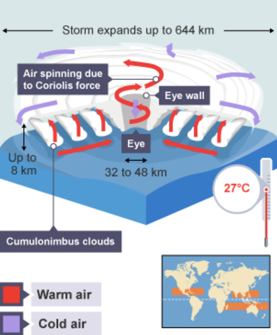
Structure and features of tropical storms
From space, a tropical storm looks like a huge whirlpool of spinning clouds.
Tropical storms are enormous, measuring up to 644 kilometres wide and up to 8 km high. They move quickly in the atmosphere, at up to 60 km/h.
Tropical storms have circulating winds because of the Coriolis force, caused by the spinning of the planet.
The area in the middle of a tropical storm is the eye. The eye is up to 48 km across. It is an area of very light wind speeds and no rain, because the air here is descending.
Huge cumulonimbus clouds surround the eye, creating the eye wall. Here warm moist air condenses as it rises and this gives the characteristic heavy rainfall and high wind speeds.
How tropical storms develop?
Tropical storms usually form between 5° and 30° latitude.
When the ocean surface waters reaches at least 27°C due to solar heating, the warm air above the water rises quickly, causing an area of very low pressure.
As the air rises quickly more warm moist air is drawn upwards from above the ocean creating strong winds.
The rising warm air spirals upward and cools. The water vapour it carries condenses and forms cumulonimbus clouds.
These cumulonimbus clouds form the eye wall of the storm.
How do tropical storms and climate change link?
Climate change could lead to tropical storms in more and different locations.
Warmer seas could allow the storms to extend further north and south of the equator.
Low-lying coasts where many people live are most at risk.
Climate change may increase or decrease the number of hurricanes, but it is likely that their intensity will increase.
rising sea levels will make tropical storms more damaging, increasing coastal flooding.
How are patterns of global temperature and rainfall affected by latitude?
higher temperatures are recorded closer to the equator, while lower temperatures are recorded towards polar latitudes. In between, there is a gradual decline in temperature due to reduced insolation - the sun is strongest at the equator and weakest at the poles.
How are patterns of global temperature and rainfall affected by continentality?
during summer, the sea heats up less quickly than the land. During winter, the opposite happens, and the sea retains heat from the sun longer than the land. Places close to the sea have slightly cooler summers, milder winters, and higher rainfall than places inland.
How are patterns of global temperature and rainfall affected by altitude?
temperatures decline as height above sea level increases. The actual rate of temperature loss is around one degree Celsius for every 150 metres of height. This is because the air gets thinner in higher altitudes. High areas also receive more rainfall and snowfall.
How are patterns of global temperature and rainfall affected by global air circulation?
this is the large-scale movement of air that helps redistribute energy across the surface of the Earth. Air is warmed near the equator, rises, and then spreads towards the poles where it cools down. It then flows back towards the equator, and the process repeats itself. The process is complicated by the rotation of the Earth which creates the Coriolis effect, which deflects the north-flowing air to the right in the northern hemisphere and to the left in the southern hemisphere.
How are patterns of global temperature and rainfall affected by prevailing winds?
some prevailing winds blow over land, while others blow over the sea. This affects the temperatures at particular locations.
How are patterns of global temperature and rainfall affected by ocean currents?
along with circulating air currents, ocean currents also help to redistribute energy across the planet. Oceans hold on to heat from the sun longer than areas of land and currents move this heat around from around the equator to the higher latitudes. Ocean currents run in giant loops (or gyres) in the major oceans in both hemispheres, and currents flowing away from the equator are called warm currents, while those flowing towards the equator are called cold currents. Both warm and cold ocean currents can affect temperatures of places close to the sea. For example, the Labrador Ocean current consists of cold water which flows southwards from Greenland towards Canada, reducing temperatures of coastal areas.
How is the unique climate of the UK affected by latitude?
higher latitudes are colder. With the UK between 50 and 59 degrees north, it receives cooler temperatures than countries in lower latitudes.
How is the unique climate of the UK affected by continentality?
in winter, the sea insulates the islands as it cools more slowly than the land and this helps to keep the UK warmer than most other countries of the same latitude. Coastal areas are warmer than inland areas in winter, because the sea retains heat and warms up the land. But in summer, areas nearer to the sea are cooler because the sea takes longer to heat up and so cools the land down.
How is the unique climate of the UK affected by altitude?
higher areas of the UK are cooler, and also receive more precipitation.
How is the unique climate of the UK affected by prevailing winds?
prevailing winds in the UK blow from the south west, across the Atlantic Ocean. This brings warm, moist air which helps to produce mild and wet winters. The west side of the UK gets more rainfall (mainly frontal and relief rain) than the east, which is in the rain shadow of the higher land on the west coast.
How is the unique climate of the UK affected by air masses?
although the prevailing wind is from the south west, there are four directions from which air travels to the UK. Each wind direction brings different climate conditions.
How is the unique climate of the UK affected by ocean currents?
the North Atlantic Drift (or Gulf Stream) ocean current flows northwards across the Atlantic Ocean, bringing warm water from the Gulf of Mexico. This results in milder winter temperatures in the west of the UK.
How is the unique climate of the UK affected by air pressure?
the UK lies in a zone of low pressure. Low-pressure systems containing lots of rainfall form over the Atlantic Ocean and approach the UK from the west. Therefore, the west side of the UK is wetter than the east. High-pressure systems (anticyclones) bringing drier weather also form over the Atlantic Ocean, and approach the UK from the west. This combination produces a mix of wet and dry conditions for the UK.
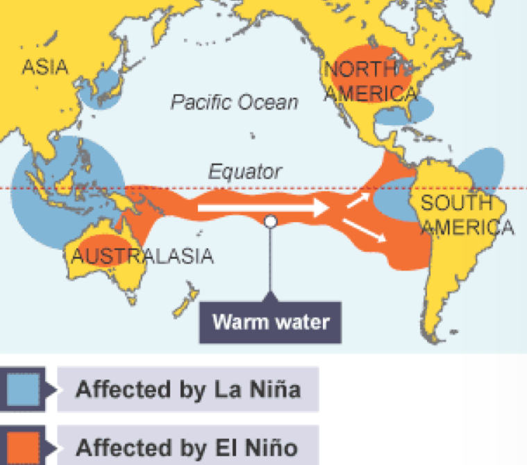
El Niño and La Niña
El Niño and La Niña are complex weather patterns resulting from variations in ocean temperatures in the east-central equatorial Pacific Ocean, between 120° west and 180° (the International Date Line).
El Niño and La Niña are opposite phases of the ENSO (El Niño-Southern Oscillation) cycle - a term describing the fluctuations in temperature between the ocean and atmosphere in this part of the planet.
El Niño
El Niño means 'the little boy' in Spanish, and is often referred to as the warm phase of the ENSO - being represented by periods of unusually warm water in the Pacific Ocean around the month of December.
La Niña
La Niña translates as 'the little girl' in Spanish, and can be referred to as the cold phase of the ENSO. It creates below average temperatures in the east-central Pacific.
Frequency of El Niño and La Niña?
El Niño and La Niña episodes usually occur approximately every two to seven years, and last for between nine and twelve months (although can sometimes go on for years). The frequency of their appearance is unpredictable, but El Niño conditions occur more often than La Niña.
Influence of El Niño and La Niña
The presence of El Niño and La Niña conditions can have a significant influence on weather patterns across a large part of the globe, including changes to rainfall patterns (often leading to flooding) and wind patterns (alterations to the trade winds), as well as making changes to sea temperatures.
Primary impacts of tropical storms
The immediate effects of strong winds, high rainfall and storm surges
Buildings and bridges can be destroyed, people can get into difficulties in the water, and roads and railways can become damaged.
Power cables and telephone lines come down, crops are ruined, and water and sewage supplies are affected. Coastal habitats like beaches and can be damaged by storm surge floods.
Secondary impacts of tropical storms
Landslides which can cause people to become homeless and can block roads and railways. This can cause evacuation problems and difficulties for the emergency services.
There can also be food and clean water shortages.
Impacts of tropical storms in LIDCs
Housing tends be of poorer quality, as is infrastructure (roads and railways), which makes it difficult to evacuate people and get emergency services to where they are needed.
More people in low-income countries depend on farming, and have their livelihoods threatened, particularly by flooding.
Poorer countries do not have the money to protect areas from flooding, or to spend on modern buildings or emergency services like hospitals, ambulances and helicopters.
Health care is also often short of the required medicines and expertise to deal with the aftermath of a tropical storm.
Responses to tropical storms
Scientists use data from satellites, radar and aircraft to track storms.
Computer models play their part, but this technology is not always available in low-income countries.
Planning of new developments can avoid storm risk areas, and buildings can be designed to withstand the high winds and flooding, by having fixed roofs and using stilts or raised banks.
Flood defences called levees can be constructed along rivers and at the coast, sea walls can be used to hold back storm surges.
Governments can provide education and information about evacuation and survival kits, and international aid such as food, water, shelter and emergency services from developed nations can help after the event has occurred.
Why do people live in hazardous areas?
They may want to stay close to friends and family, or have jobs they cannot leave.
Hazard perception is an important issue -- some people think they are safe and that the storms will never affect them.
In advanced countries there is often a feeling that the wealth and technology of the home country will deal with any disaster that hits.
Drought
a prolonged period when rainfall is below average.
Drought conditions are linked to natural changes in atmospheric circulation, but can also be made worse by human activities - often connected to farm practices.
Droughts can be severe and devastating, and pose particular threats to people living in low-income countries
Impacts of extreme weather on UK citizens
high precipitation have caused flooding to residential properties, industrial buildings, and transport links
periods of high temperatures have led to water restrictions and crop failure on farms.
warmer climate has allowed new crops like tea, grape vines and olives to be grown commercially in parts of the UK for the first time
Flood warnings in the UK
Flooding is becoming more frequent in the UK. The Environment Agency is responsible for monitoring the potential for flooding. They evaluate the risk of flooding and issue warnings for areas. They use three codes to help people be able to prepare:
Flood alert – Flooding is possible. Be alert
Flood warning – Flooding is expected. Immediate action required
Severe flood warning – Severe flooding. Danger to life.