Watershed Hydrology Midterm 2
1/152
There's no tags or description
Looks like no tags are added yet.
Name | Mastery | Learn | Test | Matching | Spaced |
|---|
No study sessions yet.
153 Terms
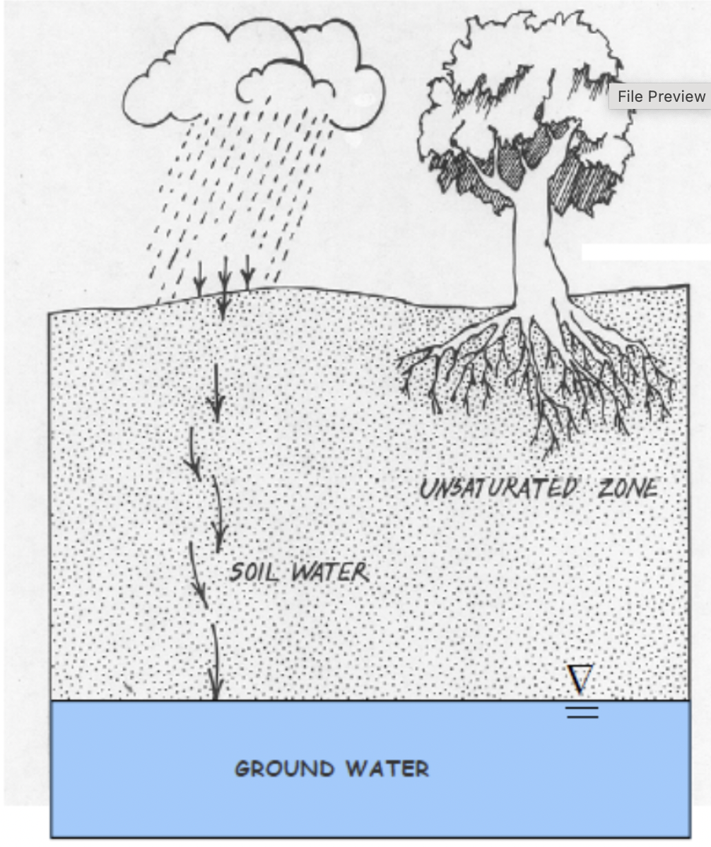
Soil Water
water moving through the “unsaturated” or “vadose” zone
Absorption
process where a liquid or other substance is assimilated within the bulk of a solid or other liquid
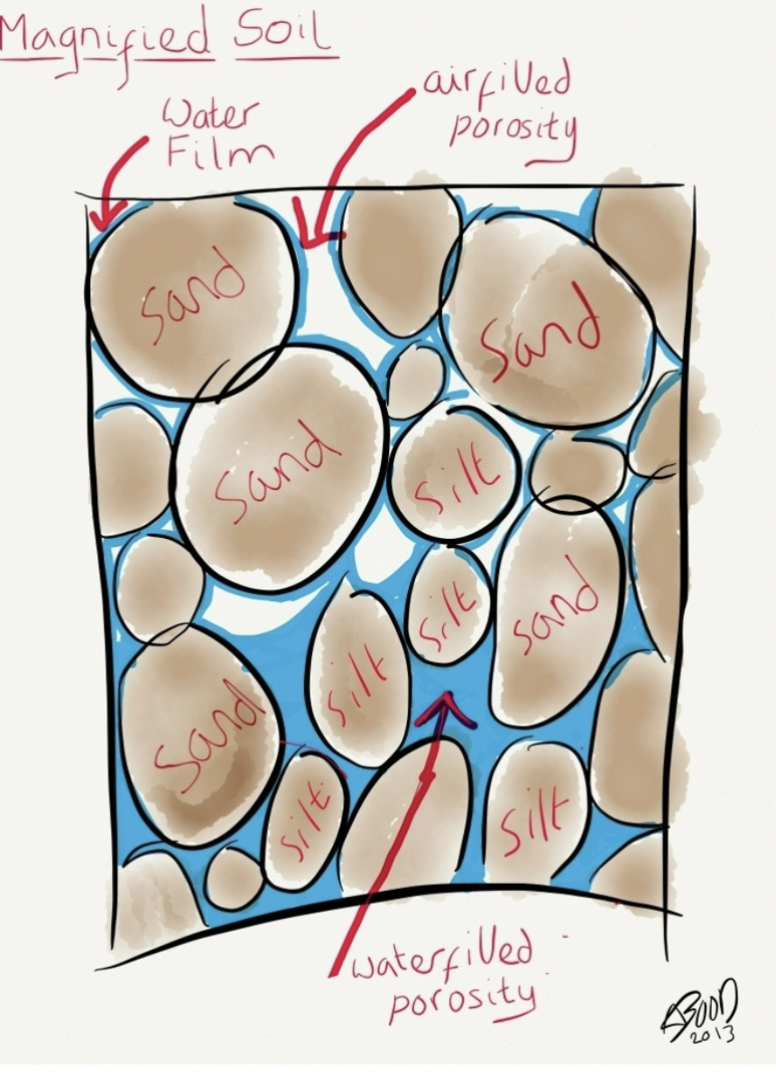
adsorption
Process where soil water accumulates on soil
particle surfaces, forming thin molecular film of
water
Porosity
proportion of material that consists of empty space → measures capacity to hold fluid
pore volume/total volume
small grain size tends to have higher porosity
total porosity
how much water a material can hold in space
higher = holds more water
effective porosity
pore space in which water can actually move (space - water film - saturated areas)
very low when pore sizes are very small = clay
permeability
how fast water can flow through a material (sand more than clay) → ability to pass water through
water is held very tightly in a thin but non-zero thickness layer to all the material’s surfaces
more surface area = more water films
high suction force, low flow
clay: porosity vs permeability
materials with very small pore space have a low permeability despite a high porosity
low effective porosity due to films created
clay holds a lot of water, but it is hard for water to flow through as it “sticks”
volumetric water content
measures how much water the material is currently holding
volume of water/bulk volume
saturation
all pores filled with water
field capacity
water in large pores has emptied (still has water film)
permanent wilting point
ground so dry that the water films are held on too tight and roots cannot uptake water
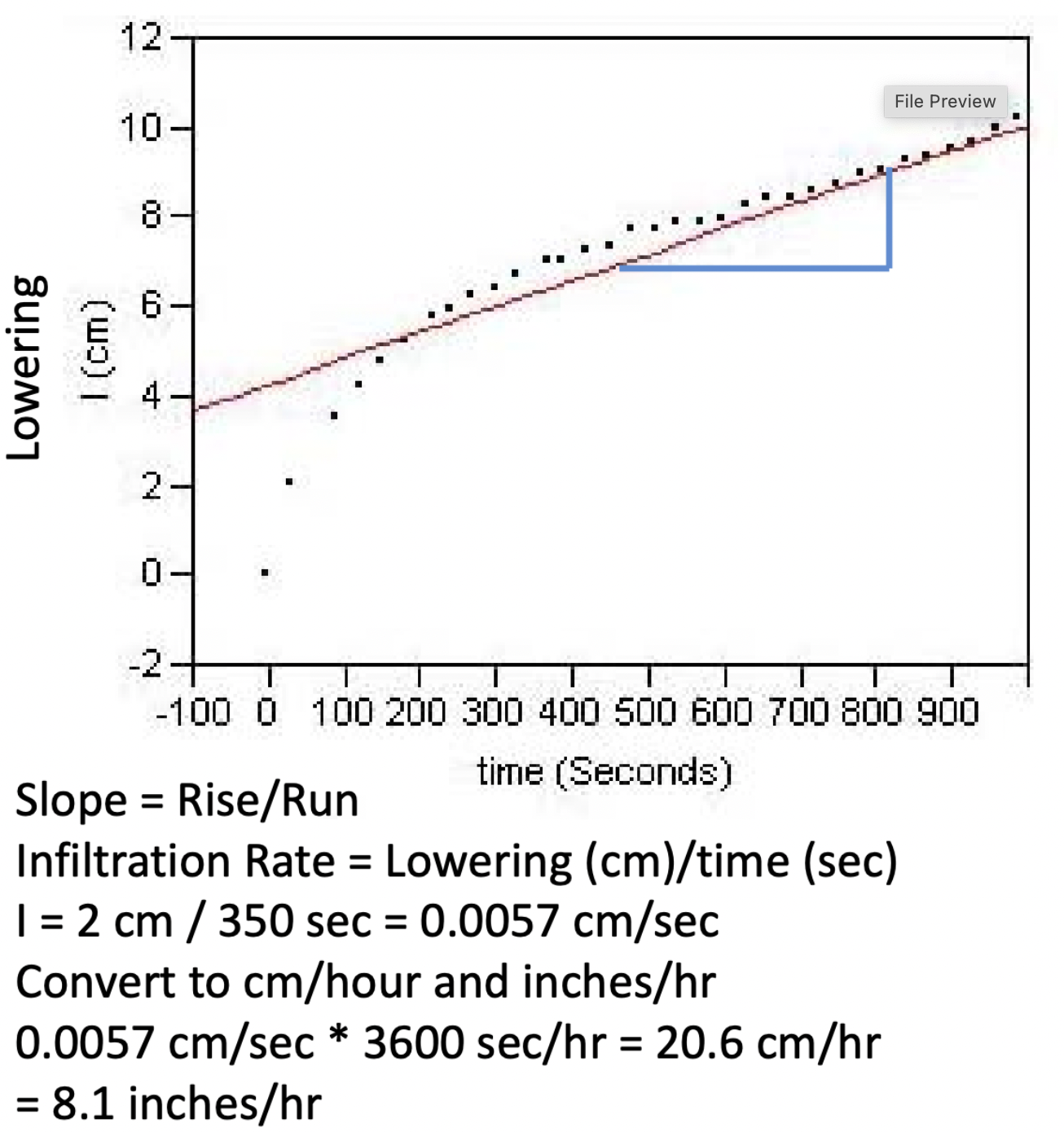
infiltration rate
measure of how quickly water will infiltrate from surface into material
typically length/time
faster when there are open spaces (dry → actively pulled in → open gaps)
length/time
unsaturated/vadose zone
zone where void spaces are filled with a mixture of air and water (held unter tension)
saturated zone
zones where voids are all water → water will flow freely
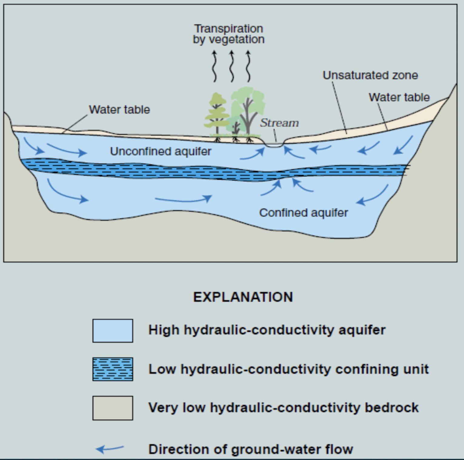
water table definition #1
boundary between saturated and unsaturated zones
groundwater
water in the saturated zone under the water table (unsaturated = soil water)
¼ water used in US is groundwater
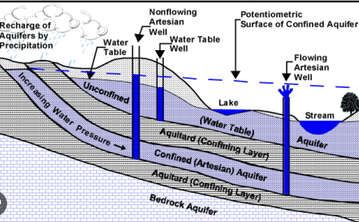
aquifer
geologic unit that contains a significant amount of water and can conduct water at a reasonable rate
aquiclude
geologic unit incapable of transmitting water (confining layer)
unconfined aquifer
upper boundary of this is the saturated/unsaturated zone
responds quickly to rainfall
fast rate of recharge
relatively short RT
well water will rise to aquifer level
confined aquifer
upper boundart is an aquiclude
recharge area small and distant
long RT
water in well will usually rise above aquifer level
multiple aquifer system
shallow aquifers usually unconfined → confined usually occur at greater depths
unconsolidated material/sediment
loose sediment, unlithified
deposited by wind, rivers, etc
grain size and permeability vary
clay → aquiclude
sand, gravel, silt → aquifer
igneous rocks
forms from the crystallization of molten rock (ex basalt, granite)
does not typically make good aquifer unless highly fractured (exception basalt)
metamorphic rocks
forms from the recrystallization of existing rocks under heat or pressure (ex marble, slate)
does not typically make good aquifer unless highly fractured (exception basalt)
sedimentary rocks
form from lithification of mineral and rock sediments
often form layers on surface and underground
if rock is porous and permeable enough, it is a good aquifer
if not permeable = confining layer
permeability depends on grain size, compression/cementation/lithification
Primary permeability
pore space between grains due to the original rock forming and depositing
Secondary Permeability
fractures and caverns created after rock formation or sediment deposition
Aquifer Properties: (n) porosity
Vvoid/Vtotal
water held in molecular films via surface tension, in small pores via capillary action/suction force
Aquifer Properties: specific yield
Sy= volume of water drained under gravity/Vtotal
water remaining is specific retention
Aquifer Properties: Specific retention
volume of water left after gravity draining (Sr) = feld capacity
Sr = volumetric moisture content after draining/Vtotal
Aquifer Properties: total porosity (n)
Sy + Sr
Effective Porosity (ne)
volume from which water can drain via gravity
only large pores are available for transmitting water
generally, ne = Sy
groundwater movement
groundwater can flow up against flow of gravity (ex artesian well)
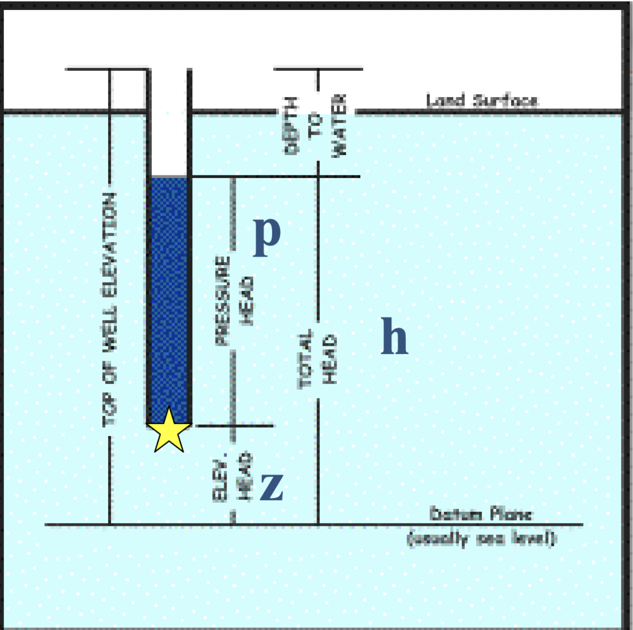
hydraulic head
a measure of total mechanical energy →controls where water goes
based on bernoulli’s law
moving water particle has three types of energy
kinetic (negligable in slow flow)
potential (elevation above datum)
pressure (function of height and weight)
→ sum of these is constant along streamline or path of flow for incompressible fluid in a frictionless system (constant = hydraulic head)
hydraulic head equation
h = z + p
if water has the same density, elevation head (z) + height of overlaying water (p)
water table definition 2
in an unconfined aquifier where overlaying water p=0; so h=z
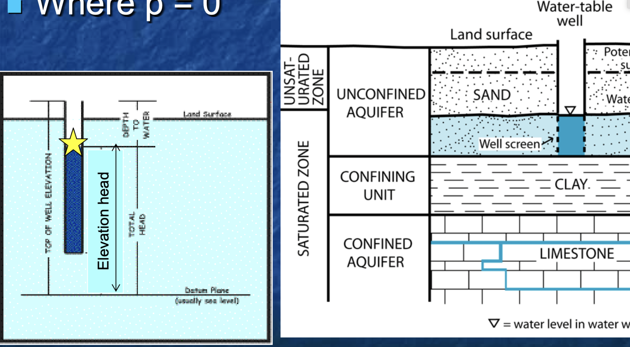
potentiometric surface definition
confined aquifer with no sat/unsat zone interference
p=0
h can rise above sat zone and even ground surface
peizometer
tube only open at the bottom → measure hydraulic head at specific location
well
intentionally get water our with screen → water rises to average hydraulic head in open area
water flow
not friction-free situation, energy lost to heat
hydraulic head decreases along steamline
water flows from high to low hydraulic head
hydrostatic
h is the same everywhere, water table or potentiometric surface creates horizontal flow = NO FLOW
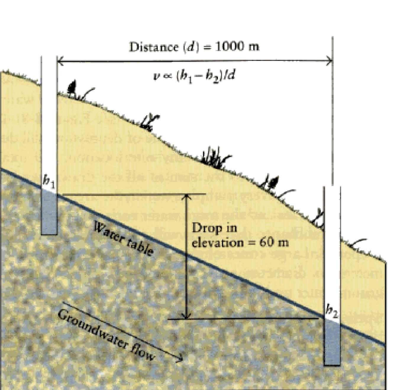
hydraulic gradient
slope of water table/potentiometric surface (rise over run)
i = h1-h2 / l1-l2
(difference in elevation / length)
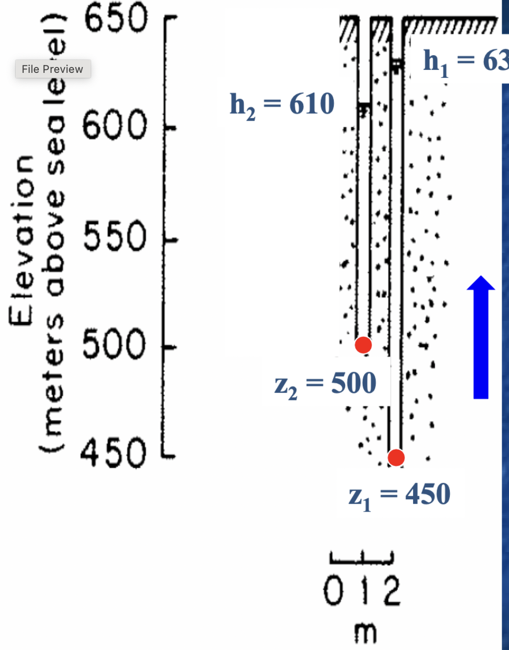
vertical gradients
calculate gradients by having adjacent piezometers with bottom openings at different depths (piezometer nest)
can also compare watr levels in a peizometer adjacent to a well with an open screen
if water levels differ, there is a vertical gradient
vertical groundwater flow
“rise” is still change in h, but “run” is now vertical distance between two well openings
steeper hydraulic gradient, the faster water will flow
change in H/change in Z = h1-h2/z1-z2
hydraulic conductivity (K)
refers to quantitative measure of the material’s ability
“permeability” is subjective, qualitative term
high K = “fast” flow, low K = “slow” flow
can range many orders of magnitude
Darcy’s Law
states that discharge through a porous medium will be proportional to the hydraulic gradient, conductivity, and discharge
Q = KiA
K gives the Hydraulic Gradient of a volume of water flowing through a 1ft by 1ft cross-sectional area
anistropy and heterogeneity
K is not the same in all directions and rarely the same in space
material variable
pores might be better connected one way than another
we are focusing on homogeneous materials
groundwater velocity
how fast are molecules flowing (how fast different materials can transmit water)
derive from darcys law
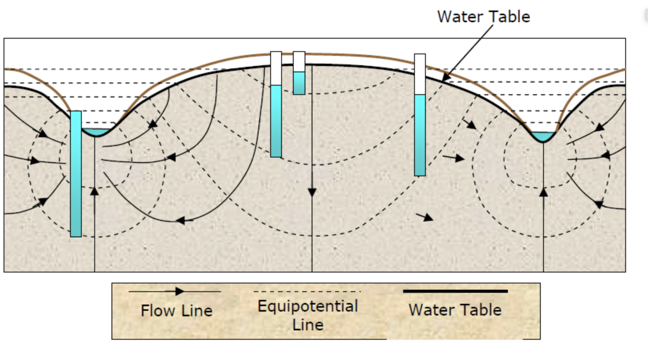
water table/potentiometric surface contours
define a surface where p=0; n=z, all mechanical energy is potential energy (at saturation rate)
lines of constant hydraulic head on that surface
a type of equipotential (p=0)
water flow always from high to low and perpendicular to flow lines
can tell you:
groundwater flow direction
horizontal hydraulic gradient
2 well situation
Know h in two locations and distance between the two
Calculate hydraulic gradient and determine flow direction
can use linear interpolation to find water table elevations in between
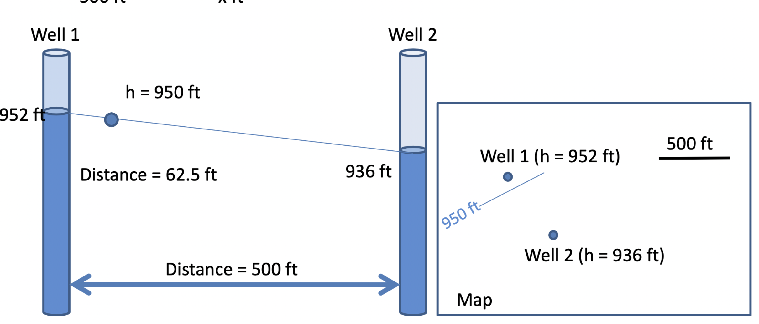
linear interpolation
elevation2- elevation1 / distance = elevation2-contour/x
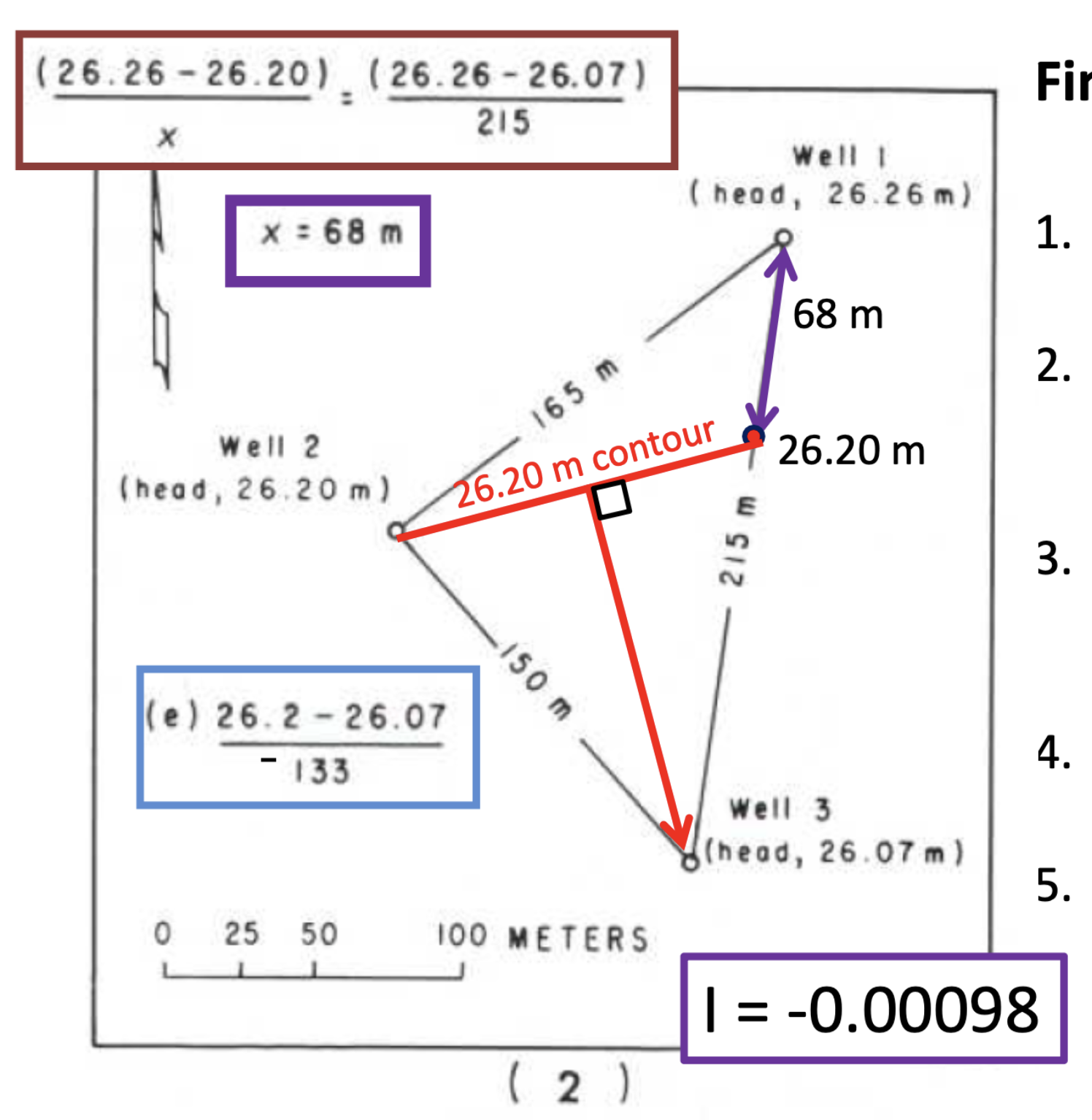
3 point situation
which well has intermediate hydraulic head
where will intermediate contour cross the line connecting the other two wells (linear interpolation)
connect linear interpolation point with intermediate well = water table contour
flow direction is perpendicular and downslope
use drop and distance from contour to either well to get gradient
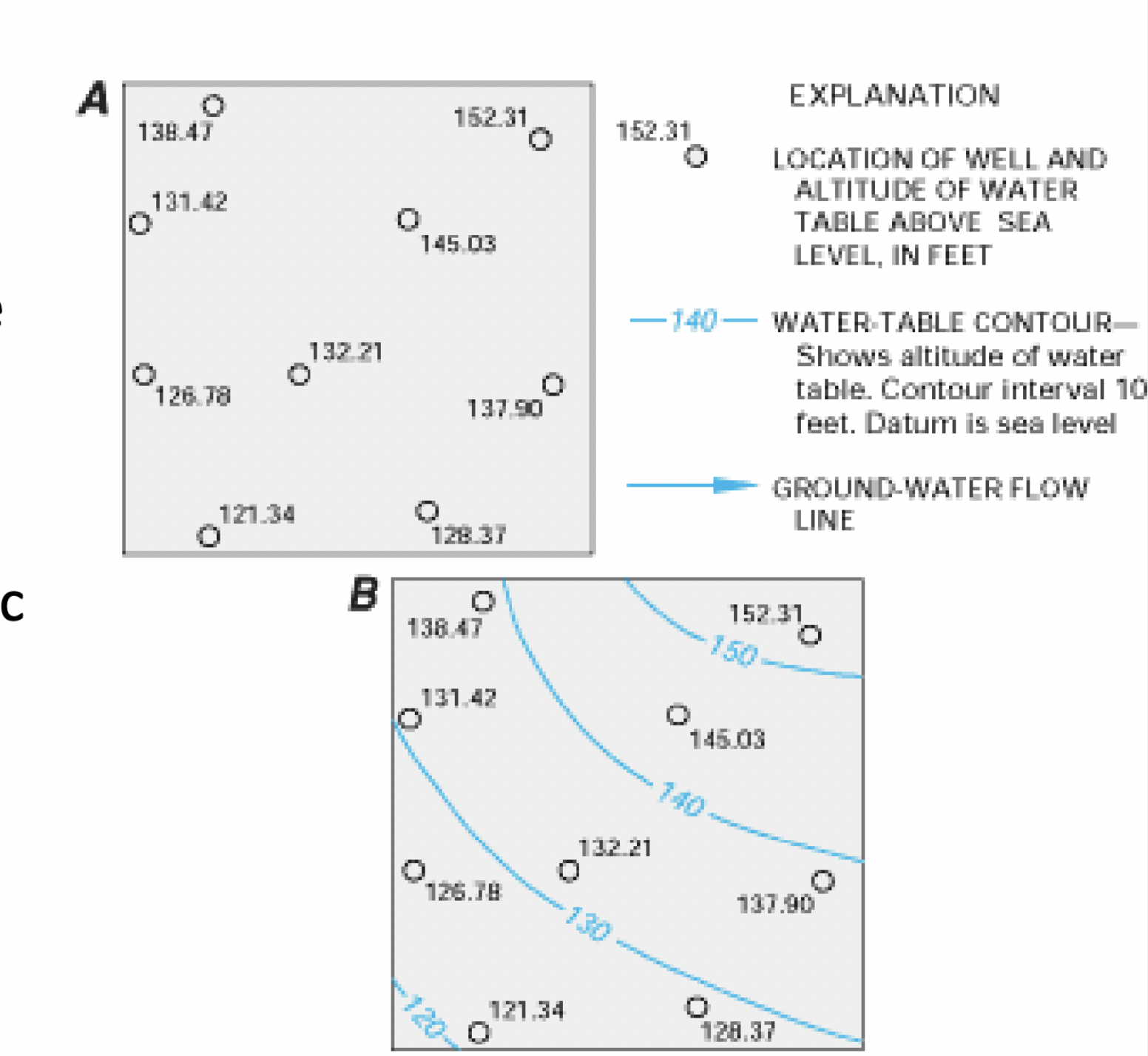
many well situation
cna create contour mapwith linear interpolation to capture hydraulic gradient and flow direction
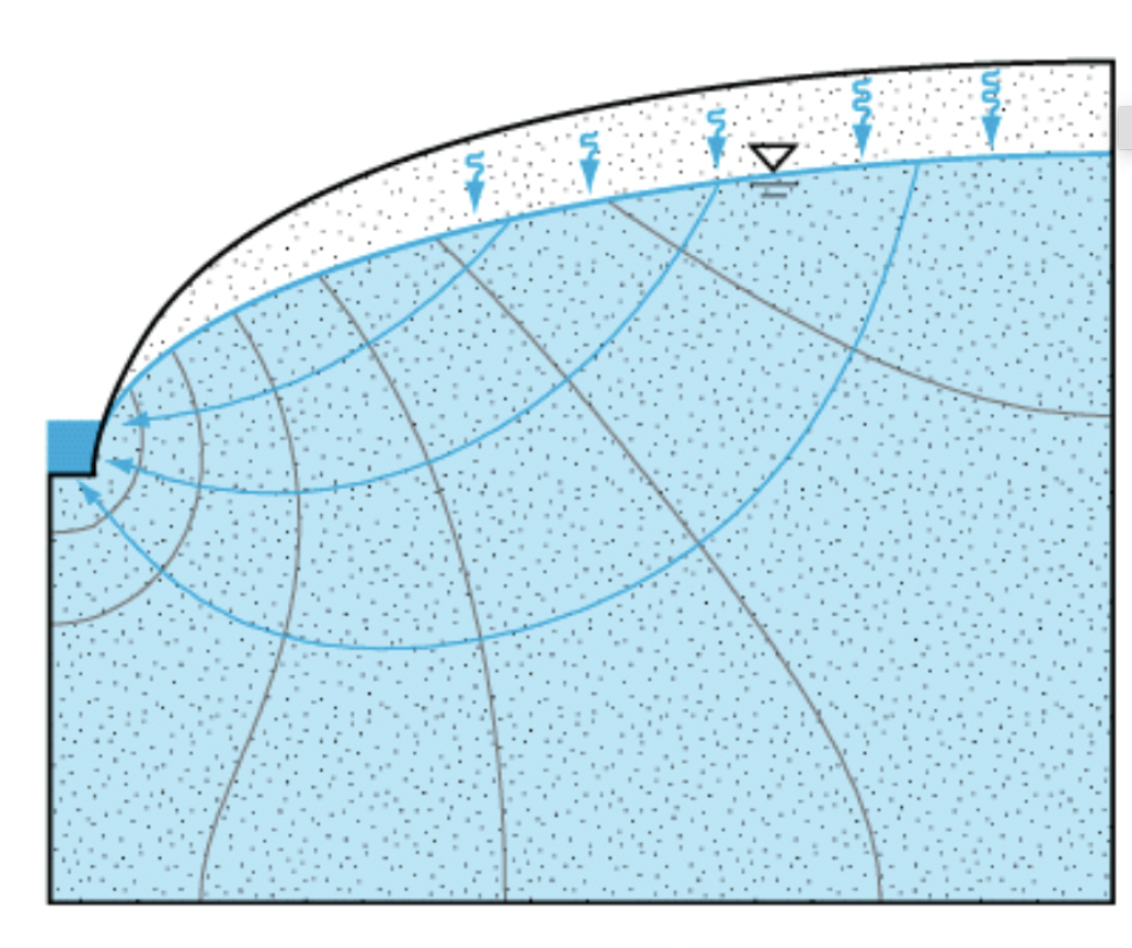
constant head boundaries
equipotential (contour, line of constant h)
lake or ocean (water table intersects land surface)
groundwater will flow perpendicular to these boundaries
water table boundaries
p=0 but h wariable
water table surface
river
water will usually flow at an oblique (not right) angle at these boundaries
flow nets
map showing both water table/potentiometric surface contours and flow lines
flow is perpendicular to contours (constant head boundaries)
flow is typically oblique to water table boundaries
show horizontal components of flow
potentiometric profile
vertical component of flow maps
water flows in three dimentions, water table contours specifically only characterize surface p=0 in map view
equipotentials
lines of equal hydraulic head where p is equal or greater than 0
vertical gradients
open portion of peizometer has same hydraulic head as the rise of the water and the water table
perpendicular, downhill to contours
in unsaturated zone, water goes directly down
constant head boundaries
water table contour
lake, ocean
PERPENDICULAR
in confined aquifer, equipotentials create perpendicular even lines in confined bed
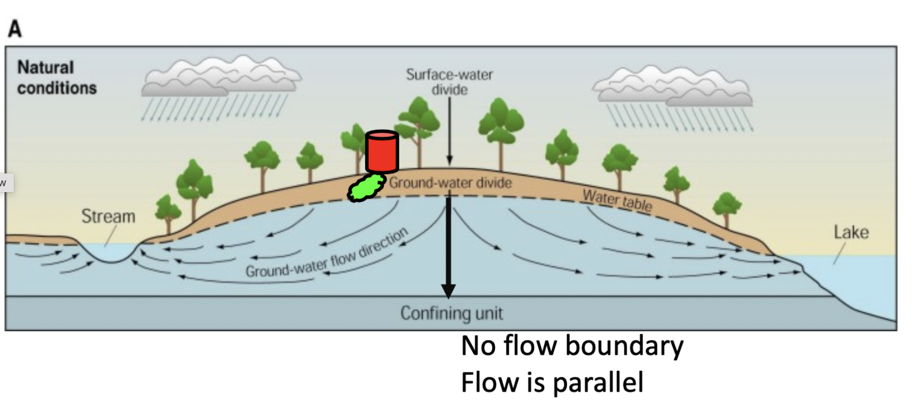
no flow boundaries
along a streamline
impermeable layer
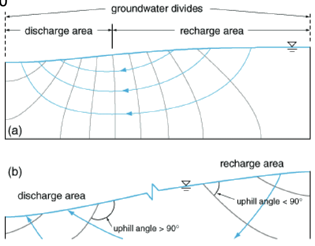
groundwater divide
PARALLEL to confining unit
flow direction and equipotentials
flow perpendicular to constant head boundaries
flow parellel to non-flow
flow usually oblique to water table
flow moving from high to low hydraulic head levels
groundwater divides
separate areas of an aquifer draining to different points
important for understanding regional flow
no-flow boundary; parallel
water table “toppography”
water table generally has the same shape as surface topography, though usually muted
groundwater discharge zones typically in topographical low spots
generally, groundwater flow high → low
flow tubes
made from flow nets
parallel or semiparallel flow between two flow lines → flow doesnt cross flow lines
discharge is constant down a flow tube (conservation of mass → water cant escape)
crosssectional areas smaller as we approach the stream → hydraulic gradient increases steeper as area decreases
equipotentials closer together
water tube drops when well is pumping (cone of depression)
recharge and discharge areas
is water flowing up or down relative to water table - angle between equipotential and water table
acute = recharge = water down
obtuse = discharge = water up
groundwater divide: peak in water table
discharge zone: dip in water table
regional vs local flow
can be over a vast area, not just water table
water can eventually percolate in deep aquifers (long RT + flow paths)
through confined aquifer
water supply wells
casing → keeps hole open
seal → prevents surface water from entering
screen → allows water into wells
pump → get water out
typical well diameters
piezometers → 0.5-1 inch
monitor wells → 2 inch
domestic wells → 4-6 inches
“production wells” → 6-20 inches
large diameter only increases yeild a little bit
matters more to determine type of pump needed
cable tool drilling
repeatedly lift and drop a heavy drilling tool in the borehole
pros: good for remote settings, low fuel consumption, inexpensive, single operator
cons: slow
auger drilling
helical, sometimes hollow drill stems spins and moves material out; widely used for site investigations, site sampling, construction
pros: inexpensive, fast, easy sediment sample
cons: only works in sediments, hole doesnt stay open
rotary drilling
uses sharp spinning drill bit and downward pressure through sediment or rock - mud or pressurized air brings cuttings to the surface
pros: leaves materials near hole undisturbed, most economical for large wells, dont need casings
cons: need large water supply and mud pit, several operators, labor expensive, large rigs
well pumping
water level in and next to well drops
hydraulic gradient gets steeper
radial flow into well; as cone of depression grows, the radius of influence expands
eventually, gradient is steep enough and roi large enough that flow into well = rate of pumping (equilibrium)
wont expand or drop under continued, steady pumping
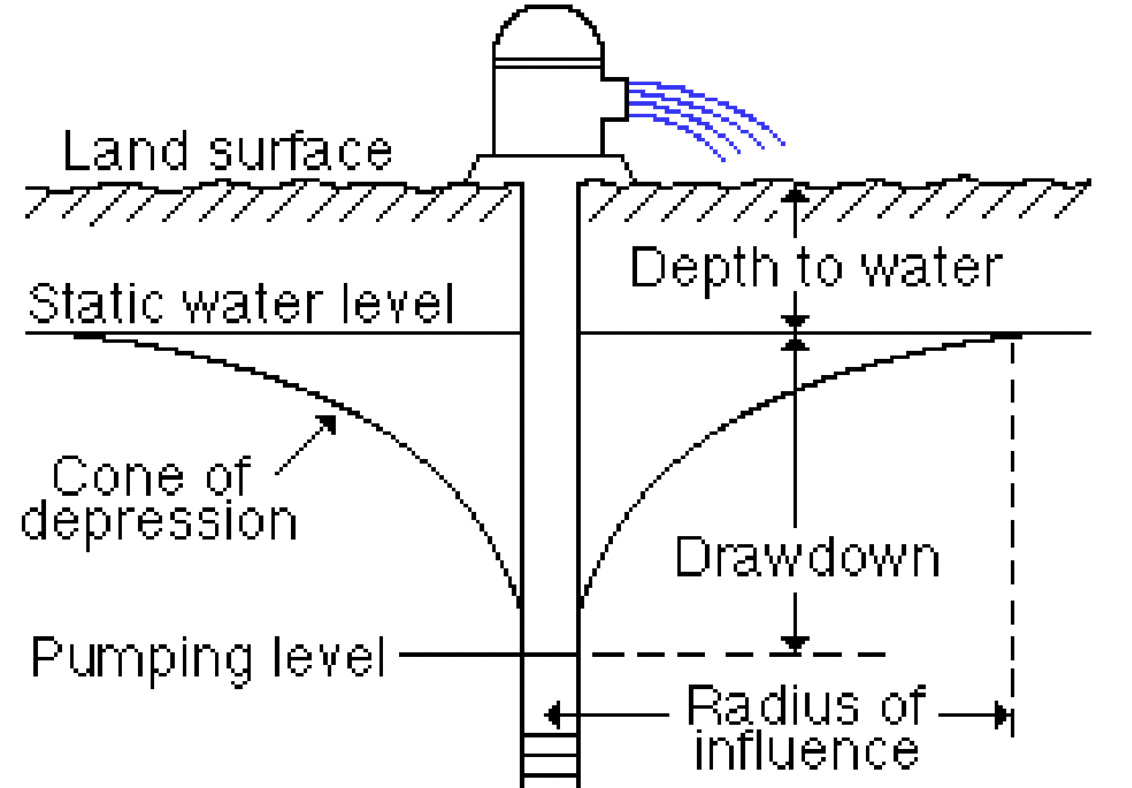
Cone of Depression
draw down and radius of influence
rate of pumping (Q0)
aquifer properties
hydraulic conductivity
how much water can be released
shape/size of aquifer
transmissivity
the volume of water flowing through a crosssectional area of an aquifer that is 1 ft x the aquifer thickness under a hydraulic gradient 1 ft x 1 ft in a given amount of time
hydraulic conductivity multiplied by the thickness of the aquifer
units of L2/T
determines if aquifer is good to put wells in
storativity (storage coefficient)
measure of aquifers ability to release water to a well - water table may lower in elevation but the pores in an aquifer won’t fill with air
S = volume of water released from an aquifer per 1 ft surface area per 1ft change in head
ranges from 0 to specific yield
equations
equilibrium conditions (water levels stabilized)
non-equilibrium (drawdown)
thiem equations
helps determine transmissivity based on equilibrium conditions
confined vs unconfined
nonequilibrium conditions
“pump tests” - pump from a well at a known rate and see how h responds
water levels dropping during test
Knowns: Q, distance from well, drawdown
solve for T and S
darcy’s law and wells
Hydraulic gradient = change in head w/distance from well (dh/dr)
• A = circumference of circular section, 2(pi)r, times aquifer thickness b
Methods
often use theis equations
graphical = cooer-jacobs method
water level at a location will drop at rate dependent on pumping rate (Q), S and T, distance from well (r )
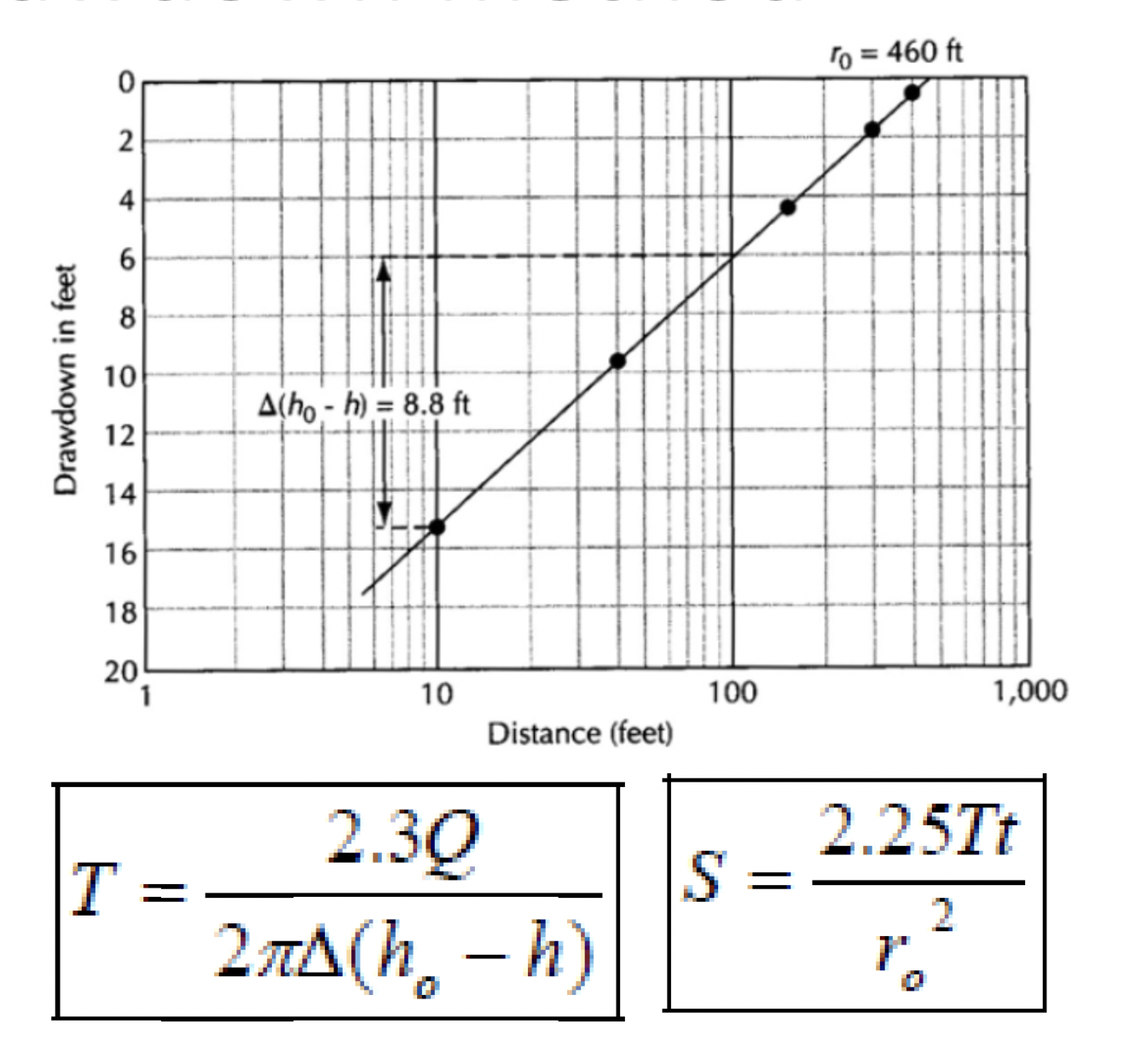
CJSL Time drawdown method
one pumping well and a single monitor well
Q in ft3/day
need r= ft
measure drawdown in well over certain length of time → graph
plot drawdown vs time on graph → use graph to determine change in h over one log cycle in time → find intercept where drawdown = 0 → convert to days
CJSL Distance drawdown method
one pumping well and at least 3 monitor wells
measure drawdown at a single point in time
meed water levels to drop over one log cycle of distance
need pumping rate
need time of measurement sincenstart of pumping t (in days)
intercept r0 in ft
Slug Tests
doesnt require pumping
can get properties by dropping slug into well, displace water, measure water seeping into ground aquifer
falling head = drop in
rising head = pull out
polluted/contaminated
if human activity alters water so it is not fit for its original use
hydrocarbons
typically less dense than water, vary in solubility
petroleum products from gas stations, heating tanks, roads (oil, coal tar, gasoline, creosote)
solvents (organic compounds)
pesticides
organic compounds
synthetic substances used industrially - long-lived, traveled slowly, can be toxic
Volatile Organic Compounds (VOCs), Semivolatile (SVOCs), chlorinated (CVOCs)
Volatile Organic Compounds (VOCs)
high vapor pressure and low water solubility
Chlorinated Volatile Organic Compounds (CVOCs)
compounds that contain chlorine, often used as solvents and degreasers, and for drycleaning and personal hygiene products
ex: Trichloroethylene, Tetrachloroethylene (PCE or “perc”)
SemiVolatile Organic Compounds (SVOCs)
higher molecular weights and boiling points than VOCs, in pesticides, solvents, cleaning agents, etc
ex: polychlorinated biphenyls (PCBs)
DNAPLs
dense non-aqueous phase liquid (sinks to bottom of aquifer)
CVOC, PCBs, Coal tar
difficult to remove
LNAPLs
light non-aqueous phase liquid (floats)
gasoline, diesel fuel, fuel oil
cause vapor problems
inorganic compounds
lead (neurotoxin)
copper (liver and kidney damage)
mercury (neurotoxin)
chromium (carcinogen)
arsenic (neurotoxin + carcinogen)\
Nonmetals (agricultural waste; yard fertilizer, septic, manure)
nitrates
phosphates
pathogens
bacteria → e.coli, cholera, giardia
viruses → enteric viruses (polio, hepatitis, meningitis)
many originate from faulty septic and sewer systems and manure lagoons
“natural” contaminents
Radon
comes from naturally occurring uranium in granitic rocks and granite-sourced sediments
Arsenic
comes from minerals dissolving from weathered rocks and soils
emerging contaminents
prescription drugs, 1 and 4 dioxane, perchlorate, microplastics, PFAS → forever chemicals
technology for detecting new contaminents is emerging
can measure very low concentrations of some (ppt or ppm)
regulations
“MCLs” maximum contmainent levels
set for drinking water, surface water, groundwater
determined by EPA and individual states
goal in remediation is to meet MCLs as cost-efficiently as possible
contaminent sources
point vs nonpoint
point source
enters environment through a discrete conveyence
well, ditch, pipe
nonpoint source
enters environment through diffuse source
agricultural, roads, mining, military properties