Hass geography revision
1/27
Earn XP
Description and Tags
Name | Mastery | Learn | Test | Matching | Spaced |
|---|
No study sessions yet.
28 Terms
Ecosystem
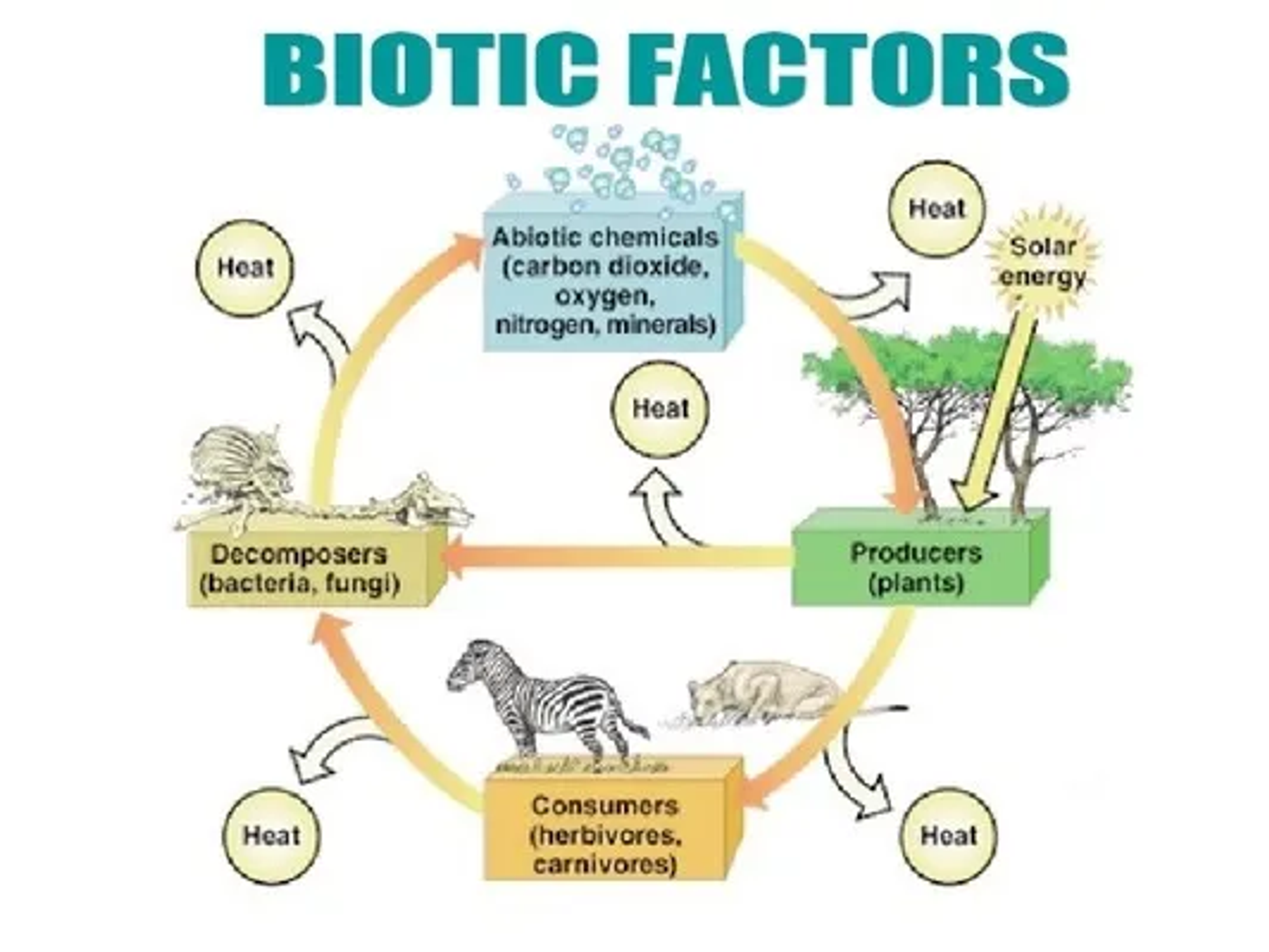
An ecosystem is a self-sustaining system where living organisms interact with each other and non-living components in an environment
Dynamics of an ecosystem
The dynamics of an ecosystem is how energy is transferred amongst the system and throughout. This starts from the sun and carries on to the producers, consumers, decomposers and finally the abiotic components.
Structure of an ecosystem
The structure of an ecosystem is characterised by the organisation of producers then consumers, and finally decomposers.
Lithosphere
The solid part of the Earth’s crust, consisting of rocks and soil.
Hydrosphere
All of Earth’s water bodies, including lakes, rivers, streams, oceans, ground water, and ice caps
Atmosphere
Layers of gas surrounding the Earth
Biosphere
Consists of living things including plants, animals, bacteria, fungi, and all other living components.
Abiotic factors
Non-living components that are influential in controlling the function of the ecosystem. This includes air, sun, soil, water, and basic compounds and elements of the environment.
Classified as climatic (temp, wind, rain) or edaphic (soil, minerals, topography)
Biotic factors
Living components in an ecosystem. This includes animal, plant, and microbial communities.
They are divided into trophic levels within a food chain:
- Autotrophs (Core of all biotic systems): self-feeding
- Heterotrophs: consumers
- Saprotrophs: decomposers
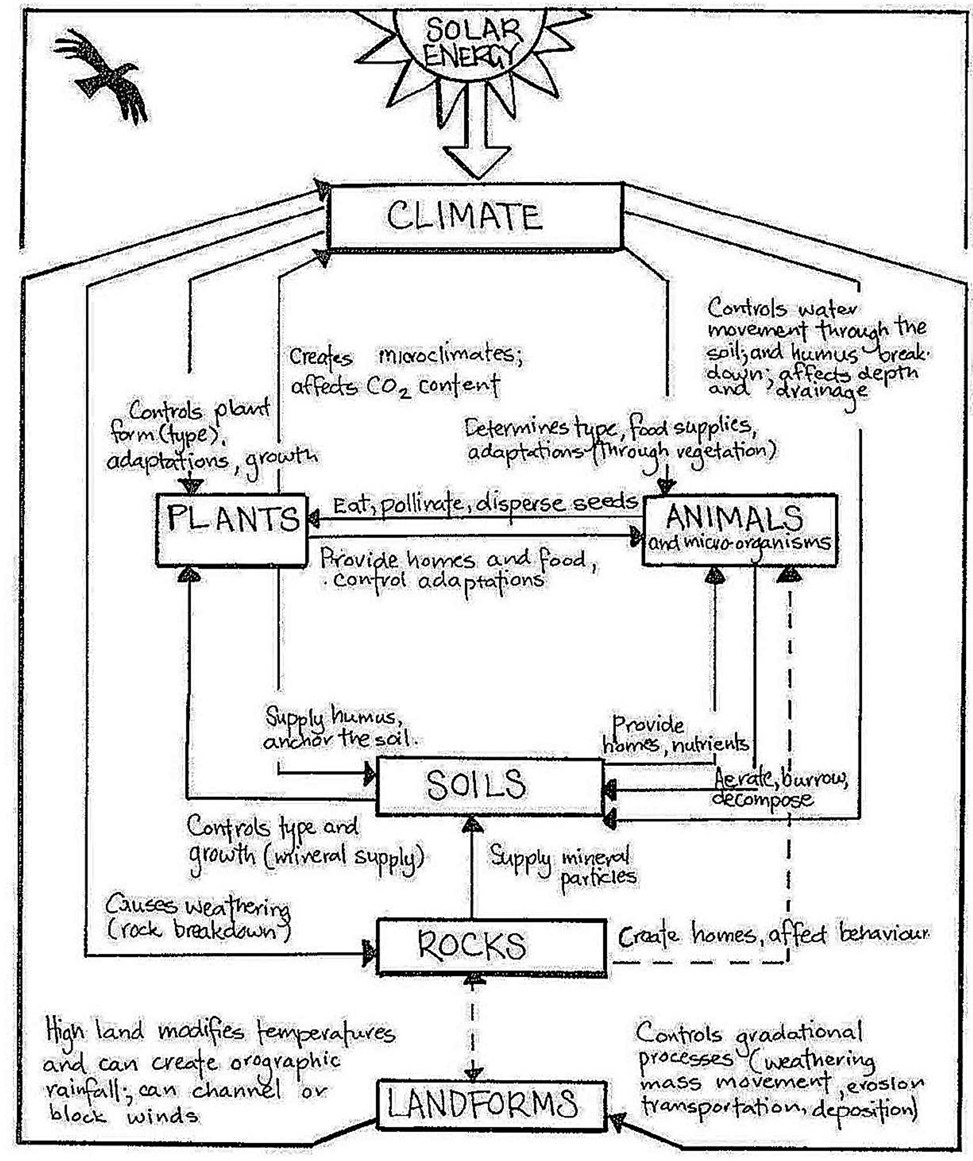
Components of an ecosystem
Climate
Fauna
Vegetation
Soils
Landforms
Biomes
Biomes are areas classified by the dominant vegetation in that location.
Difference between biomes and ecosystems
The difference between biomes and ecosystems is that biomes are large geographic regions defined by their climate, dominant vegetation, and wildlife, such as deserts or rainforests, and encompass multiple ecosystems within them. ecosystems are smaller, specific areas within biomes where living organisms interact with each other and their physical environment, such as a coral reef. Ecosystems focus on the detailed interactions between organisms and their environment within an area.
Types of biomes
Tropical rainforest
Temperate (deciduous) forests
Taiga
Woodlands
Savannah grasslands
Temperate grasslands
Desert
Tundra
Alpine
Spatial distribution
Spatial distribution is the arrangement of a phenomenon across the Earth's surface.
Spatial distribution of biomes
The spatial distribution of the different biomes depends on the biomes latitude, climate, and altitude. The higher the latitude, the lower the amount of sun reaches the biome. Different areas receive different amounts of rainfall and levels of temperature. The higher the altitude, the cooler the temperature. These all directly affect the vegetation available, therefore influencing the spatial distribution of biomes
Climate
Climate is the long-term average of weather patterns in a region including factors of temperature and rainfall.
Weather
In contrast to climate, weather refers to short-term, day-to-day atmospheric conditions, such as daily changes in temperature, precipitation, and wind.
Koppens climate classification
The Koppens climate classification is a system which categorises climate zones throughout the world based on rainfall and temperatures.
Koppens divisions and descriptions
A (tropical): Warm temperatures year-round, high precipitation, located near the equator
B (arid): low precipitation, dry, usually deserts/ tundras
C (temperate): Moderate temperatures, with distinct seasons.
D (continental): More extreme temperature variations between seasons, more inland
E (polar): Cold temperatures year-round, with short, cool summers, higher altitudes
Climate graph
A climate graph combines both line graphs and column graphs to show the average rainfall and temperatures experienced at a place throughout the year.
LAPDOG
Latitude
Altitude
Prevailing winds
Distance inland
Ocean currents
Great mountain barriers
Latitude
Refers to the place's position in relation to the Equator.
Places closer to the Equator experience warmer climates due to more direct sunlight. Polar regions, further from the Equator, receive less direct sunlight and are generally cooler. The angle of sunlight affects the intensity of heat received.
Altitude
The height of a location above sea level
Higher altitudes typically have cooler climates because temperature decreases with elevation. Temperature falls 6.5 degrees every 1000 metres.
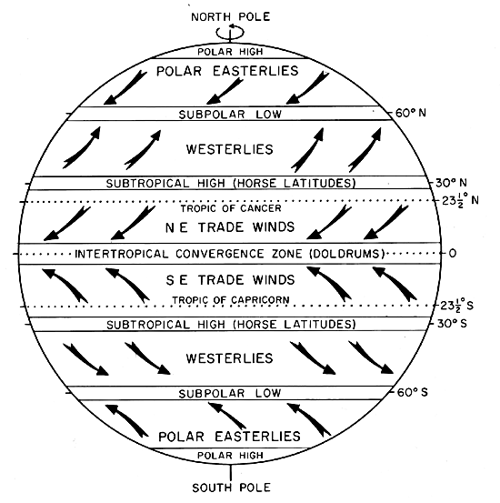
Prevailing winds
The global wind patterns that distribute heat and moisture around the Earth and are most predominant in a specific area
Winds move warm air towards higher latitudes and cooler air towards lower latitudes. The movement of warm air rising and cool air sinking creates circular air patterns. Winds from colder regions contribute to cooler climates, while winds from warmer regions bring higher temperatures. Winds passing over oceans can carry moisture, leading to increased rainfall in coastal areas.
Distance inland
How far a region is from the coastline.
Land heats up and cools quicker than the ocean. The temp of oceans and seas remains about the same throughout the year.
The further away an area is from the coast, the more extreme its climate is likely to be. Places closer to the sea have milder temps and higher rainfall while places further away experience more extreme climate.
Ocean currents
Cyclic movements of ocean water that flow through the Earth's oceans.
Ocean currents can significantly impact the temperature and precipitation of coastal regions. Warm currents flowing from the equator increase temps and rainfall in areas it passes. Cold currents moving towards the equator reduce temps and rainfall in areas it passes. Oceans hold more heat than the atmosphere and land
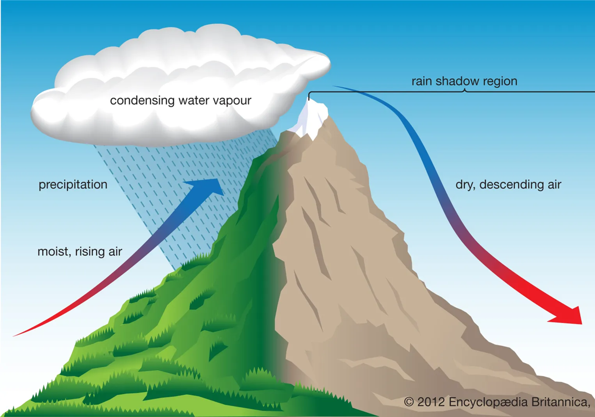
Great mountain barriers
Physical features such as mountains that affect climate by influencing precipitation patterns.
Mountains act as barriers to air movement, impacting precipitation levels on their windward and leeward sides. The windward side, facing prevailing winds, receives more rainfall as moist air is forced to rise, cool, and condense into precipitation. The leeward side, sheltered from prevailing winds, experiences drier conditions known as rain shadows.
The uplift of air over mountains leads to cloud formation and rainfall on the windward side, while the leeward side remains dry due to the descending, warmer air.
4 natural systems
Heat budget
Hydrological cycle
Atmospheric circulation
Carbon cycle