Introduction to Environmental Biology Exam 1 - WashU Fall 2025
1/93
There's no tags or description
Looks like no tags are added yet.
Name | Mastery | Learn | Test | Matching | Spaced |
|---|
No study sessions yet.
94 Terms
Since when have humans been significantly modifying the environment? When was the agricultural revolution? When is the anthropocene proposed to have begun?
Since the late Pleistocene, when they hunted many large mammals to extinction;
there is some debate, however, that climate change was also a very significant factor
-agricultural revolution was ~10,000-8000 bp
-anthropocene is proposed to have begun in 1950, marking when humans have had a massive global effect on the environment and climate
Filler
Filler
What is a tropic cascade? What is primary production? What are communities vs ecosystems?
Changes in ecosystem species abundances triggered by removal or addition of top predator; can also occur btw ecosystems
-a community consists of all the interacting living organisms in a particular area, while an ecosystem includes the community of living organisms plus all the non-living (abiotic) factors in that area, plus cycling of nutrients and flow of energy
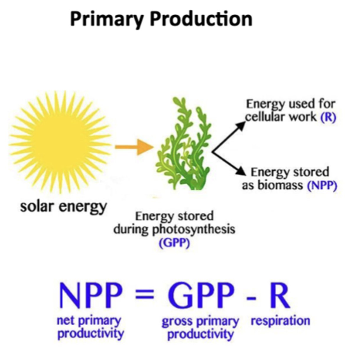
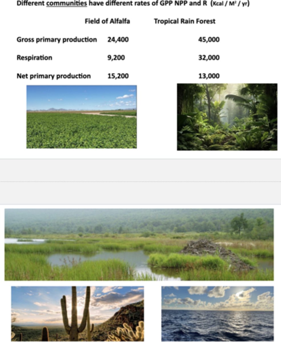
What is primary production? What is net primary productivity (NPP)? Is photosynthesis "efficient"? Why is net productivity greater in an alfalfa field than in a tropical rain forest?
Primary production is process where organisms (primary producers or autotrophs) create organic matter from inorganic substances, typically using sunlight for energy via photosynthesis
-plants, algae, and photosynthetic organisms capture sunlight and convert it into chemical energy (sugars), and the total energy captured is called Gross Primary Productivity (GPP); a portion of this energy is used for cellular work (R, respiration) and the remainder is stored as biomass, available to consumers in the food web
~net primary productivity is defined as the energy stored as biomass after respiration: NPP = GPP - R, representing the energy that actually supports herbivores, decomposers, and higher trophic levels; shows photosynthesis is inefficient- only a small fraction of solar energy becomes biomass, and this process can reverse (respiration releases CO₂)
-tropical rain forest has very high GPP bc of year-round sunlight, warmth, and biodiversity but also very high respiration rates due to warm temps and dense plant metabolism, meaning much of the captured energy is used up by the plants themselves, leaving lower NPP relative to GPP; alfalfa is a crop plant bred and managed for growth efficiency, growing rapidly with dense strands and less structural biomass compared to rainforests, so respiration rates are proportionally lower and a greater energy fraction goes into NPP
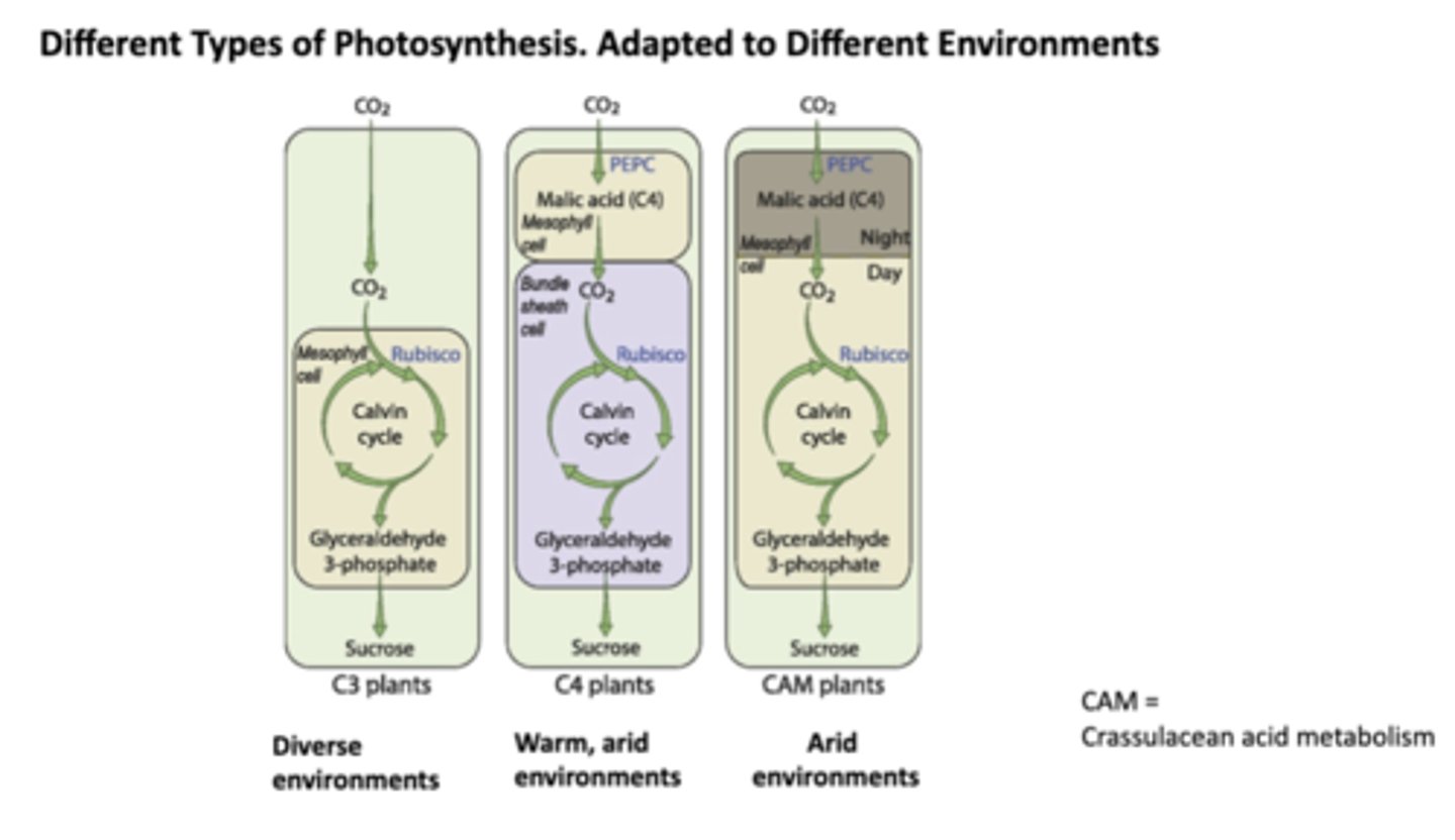
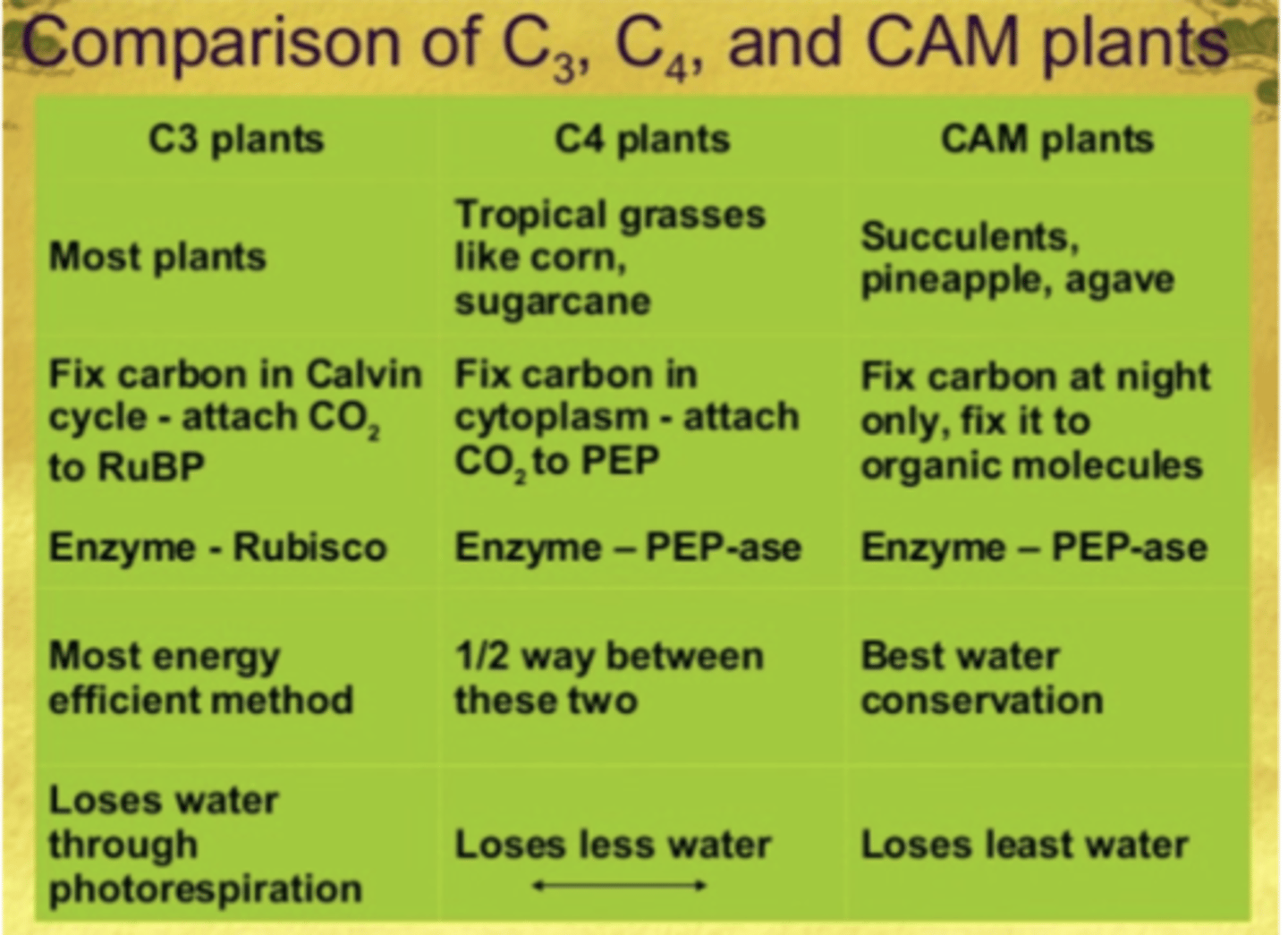
What are the three main photosynthetic pathways? In what environment does it work best?
C3, C4, and CAM
-in C3, CO₂ enters directly into the Calvin cycle inside mesophyll cells, where the enzyme Rubisco fixes it; works well in cool, moist, and diverse environments where water loss isn't extreme (i.e. common trees), as disadvantage lies in the fact that Rubisco sometimes fixes O2 instead of CO2, leading to photorespiration which wastes water
-in C4, CO2 is initially fixed in mesophyll cells by the enzyme PEPC into malic acid, which is transported to bundle sheath cells where CO2 is released and fed into the Calvin cycle, where Rubisco is; advantage is that it concentrated CO2 around Rubisco, minimizing photorespiration and thus adapted to warm, arid environments with high light intensity (i.e. sugarcane)
-in CAM, at night stomata open, allowing PEPC to fix CO2 into malic acid, while during the day stomata close to save water, causing malic acid to release CO2 to the Calvin cycle; conserves water by keeping stomata closed during hot daytime, and thus is adapted to arid environments (i.e. pineapples, cacti)
Comparison of C3, C4, and CAM plants
Picture
In what units are photosynthetic rates measured?
Measured by CO2 uptake in mg / cm of leaf tissue / hr (for ex, C4 agriculture = 50-80 mg/cm/hr, C3 agriculture = 20-40 mg/cm/hr, grasses = 6-12 mg/cm/hr, deciduous trees = 10-20 mg/cm/hr, conifers = 4-15 mg/cm/hr, ferns = 3-4 mg/cm/hr)
-
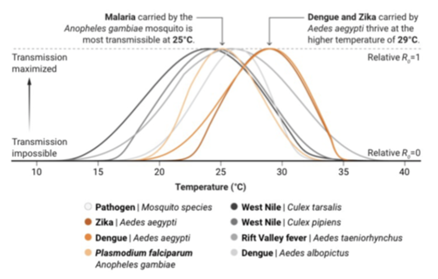
What is the concept of One Health? What are zoonotic diseases and how are they temperature dependent?
An interdisciplinary approach that recognizes the interconnectedness of human, animal, and environmental health, emphasizing the importance of collaboration between healthcare professionals, veterinarians, scientists, policymakers, and other stakeholders to address health issues that transcend these boundaries
-zoonotic diseases are spread from animals to humans (i.e. Oropouche virus spread through midges, yellow fever, zika, and malaria from mosquitoes)
~many zoonotic diseases are temperature dependent bc temperature affects the survival, reproduction, and activity of pathogens, vectors, and host animals, influencing their geographical distribution and transmission dynamics; for ex, mosquitoes are most likely to live and reproduce in the southern US
How can toxins spread through trophic levels and through an ecosystem? What is bioaccumulation? How can antibiotic resistance spread through a wild population?
Compounds which kill certain creatures like rats, mice, and insects can also threaten may other kinds of wildlife including their predators and scavengers; for ex, in red-tailed hawks, anticoagulant rodenticide poisoning can cause anemia and internal bleeding
-additionally, nontarget animals can consume toxins (i.e. slugs and snails consuming rodenticides)
-bioaccumulation is gradual buildup of a substance such as a toxic chemical in a living organism over time, often in fatty tissues, bc the organism cannot break it down or excrete it quickly enough
-antibiotics can move btw components of an ecosystem, like when humans include antibiotics in domesticated animal feed or otherwise spread drug resistant bacteria to the environment: for ex, sampling number of wild bird populations found more lineages = more bacterial genomes (bacteria that's colonized birds adapting to antibiotics)
~our environment has bacteria in it which are antibiotic resistant, which then moves back into the human population

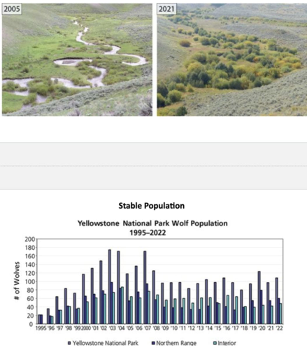
How have wolves been used in Yellowstone National Park to stabilize the ecosystem?
Wolves were extirpated from Yellowstone in the 1920s due to hunting and predator eradication programs; without wolves, elk populations exploded because their main natural predator was gone, then overgrazing by elk heavily damaged riparian zones (riverbanks), aspen, and willow forests that provided habitats for many animals
-in 1995-1996, gray wolves were reintroduced from Canada into Yellowstone National Park, sparking a trophic cascade, a chain rxn of ecological effects which flow thru food web; re-balanced the ecosystem allowing vegetation recovery, return of beavers which use willows for food and dams, these dams created wetlands to benefit amphibians and fish, and so on
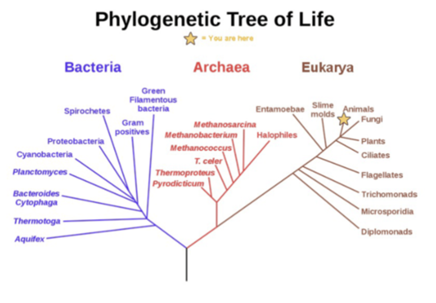
What is phylogeny and phylogenetic trees?
The study of the evolutionary history and relationships of species or the evolutionary history of a particular organism or group
-phylogenetic trees are branching diagrams that visually illustrate evolutionary relationships and shared ancestry btw different species or groups of organisms
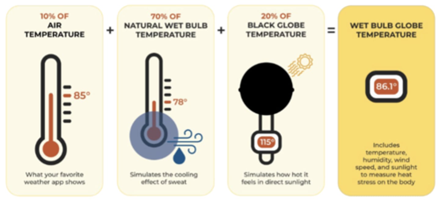
What is dry-bulb vs wet-bulb temperature? How is wet bulb globe temperature (WBGT) calculated?
Dry-bulb temperature is standard measure of air temperature, while wet-bulb temperature reflects cooling effect of evaporation and indicates how humid the air is (scientists measuring human heat tolerance use wet-bulb temp, w many considering wet-bulb temp of 35 degrees C to be the physiological limit)
-WBGT is a composite temperature index that accounts for multiple environmental factors to estimate heat stress on the human body more accurately than just air temperature; comprised of dry bulb temperature (10%), natural wet bulb temperature (70%) and black globe temperature/how hot it feels in direct sunlight (20%)
How does heat interact with air pollution?
Heat worsens air quality by increasing rate of chemical rxns that form ozone and other harmful secondary pollutants, while stagnant air masses trapped by high-pressure systems during heatwaves prevent pollution from dissipating
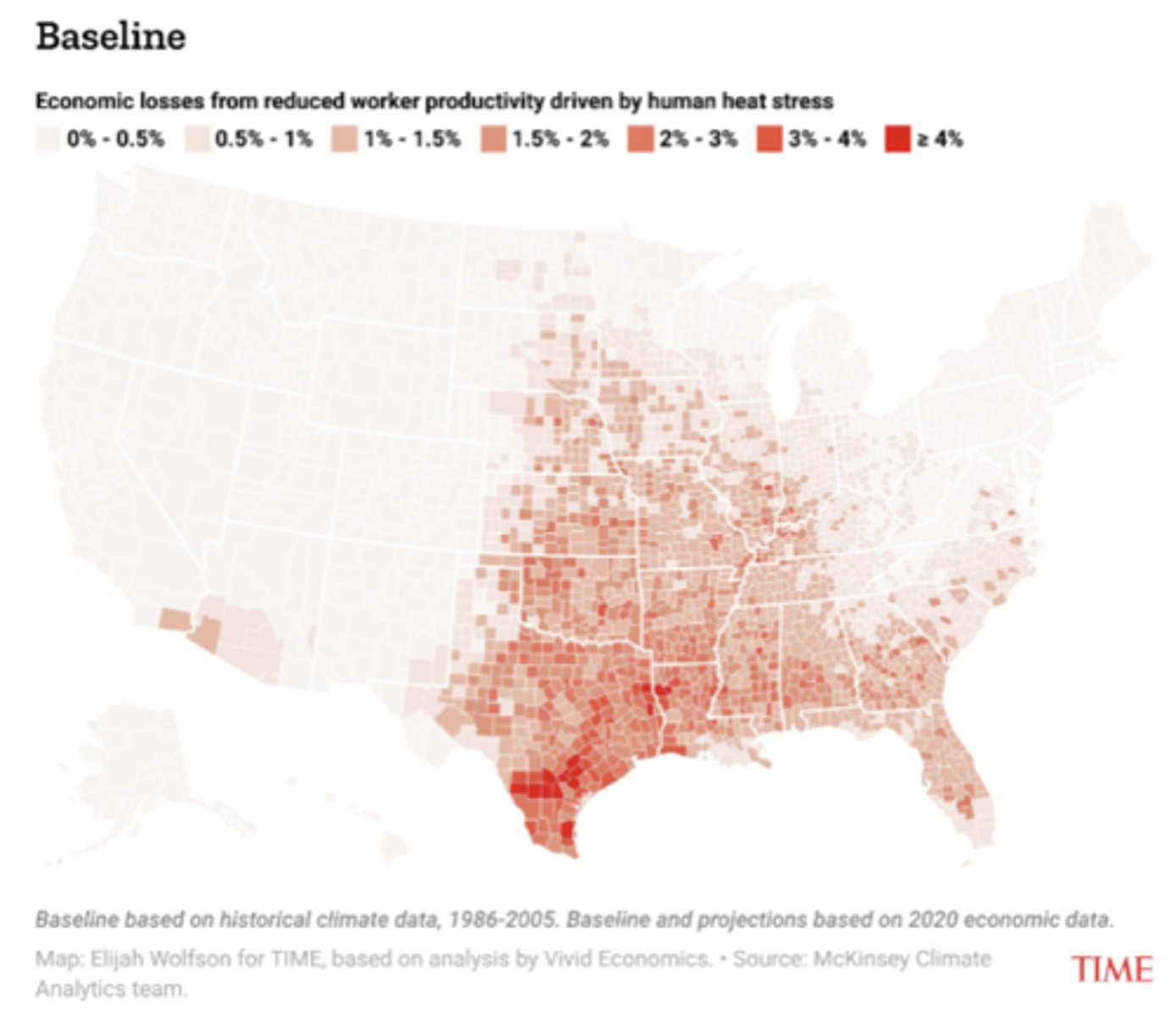
What are the physiological, health, and societal effects of extreme heat on humans?
When temperatures rise above what the body can regulate, stress occurs; via thermoregulation, the body cools itself mainly by sweating and dilating blood vessels near the skin, though high humidity reduces the effectiveness of sweating and excessive fluid loss through sweat → dizziness, fainting, kidney strain
-additionally, the heart works harder to pump blood to the skin for cooling, increasing risk for people with heart conditions; if cooling fails, body temperature increases, leading to heat cramps, heat exhaustion, and heat stroke
-associated with higher rates of heat-related illness and mortality (especially among elderly, outdoor workers, and those with chronic diseases) and worsening of respiratory issues bc heat often coincides with poor air quality; warmer weather also allows mosquitoes, ticks, and pathogens to thrive in regions where they previously couldn't
~there's also a strong correlation btw more intense heat and worse sleep
-outdoor laborers face higher risk, which can cause reduced productivity and economic losses, cities get hotter than rural areas due to concrete retaining heat, hot days are detrimental to mental health, and heat waves increase risk of blackouts
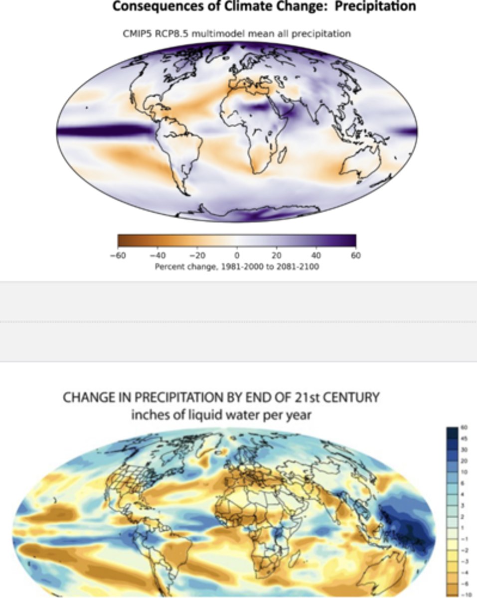
How are global precipitation trends projected to be influenced by 2100?
Top map compares average average precipitation from 1981-2000 to projected patterns for 2081-2100; high latitudes (Canada, N Europe, Siberia, Antarctica) are wetter and tropics (equatorial Pacific, parts of E Africa, SE Asia) are wetter, while subtropics (Mediterranean, North Africa, Australia, SW US) are drier
-bottom map shows the absolute amount of change in inches of liquid water per year rather than a %: strong precipitation increases in the tropical Pacific Ocean, Indian Ocean, and high latitudes with significant drying in southern Europe, the Mediterranean, southern Africa, Australia, and parts of Central America
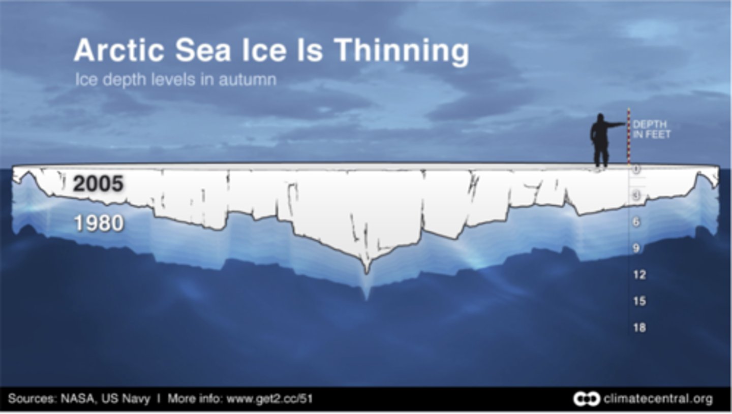
How has Arctic Sea Ice changed in thickness between 1980 and 2005?
Became substantially thinner between 1980 and 2005 due to the replacement of older, thicker multiyear ice with younger, thinner seasonal ice, a process that accelerated in the mid-1990s and early 2000s and was linked to preconditioning by warmer air temperatures and feedback loops from changing albedo
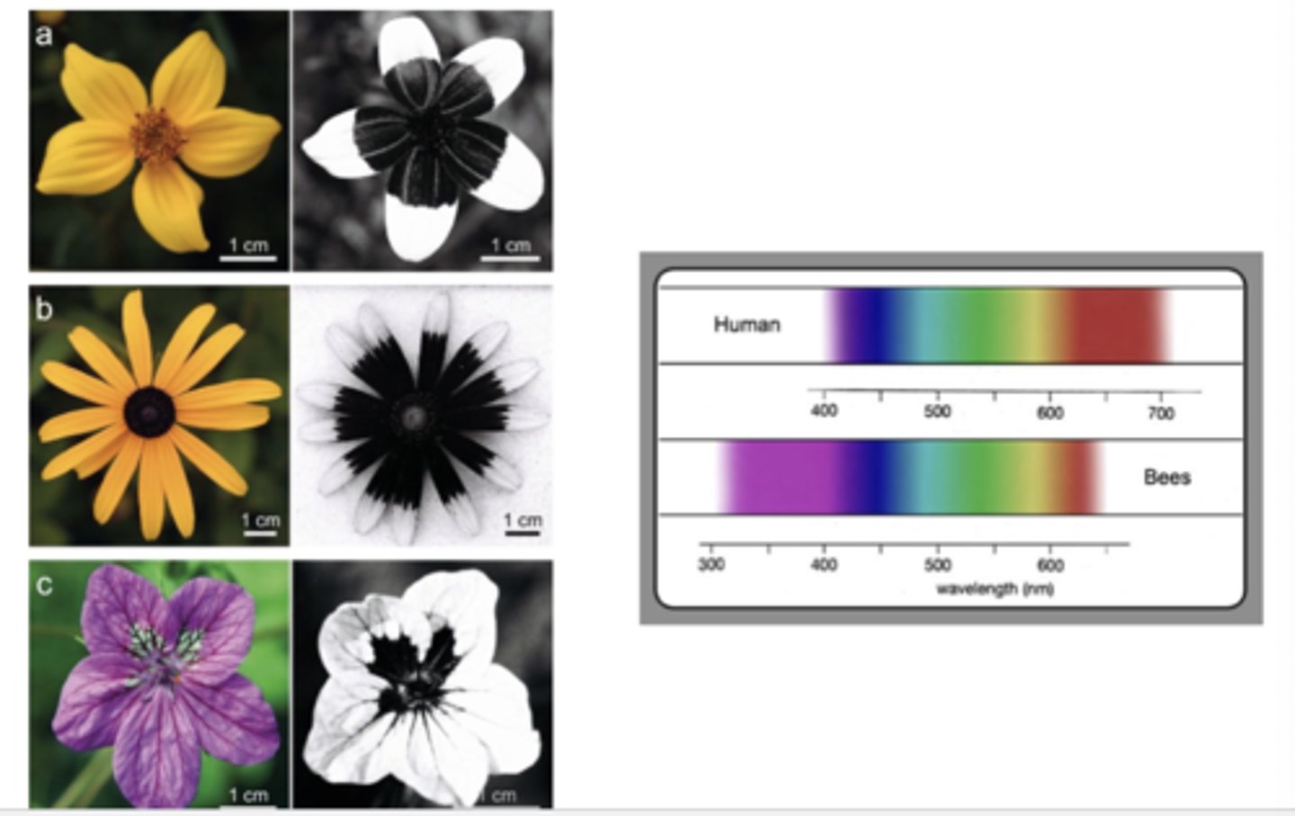
Bees are key pollinators for many crops and natural ecosystems. How is it affected by heat? How are bees attracted to flowers and how is this impacted by heat?
High temperatures affect bee foraging by causing dehydration, increasing the risk of overheating, and reducing activity levels, leading bees to shorten foraging trips, seek cooler areas, or stop foraging altogether
-bees are attracted to flowers by visual signals which can be outside human color vision; flowers also use sweet scents, specific shapes that provide landing platforms, and visible nectar guides
~heat impairs bees' sense of smell, disrupting their ability to find flowers
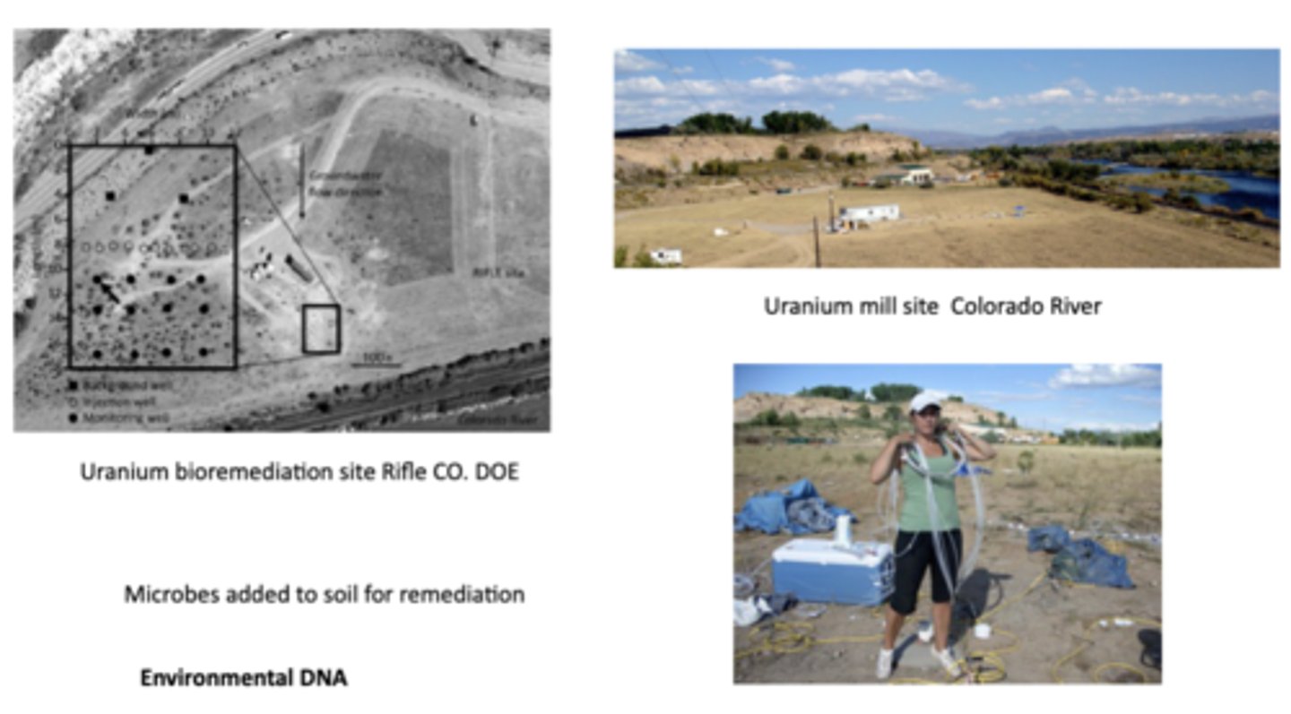
What is purple bacteria? What is green sulfur bacteria? What is bioremediation and what is an example of it at work in Colorado? eDNA sampling?
Purple bacteria or purple photosynthetic bacteria are Gram-negative proteobacteria that are phototrophic, capable of producing their own food via photosynthesis; green sulfur bacteria are anaerobic, photosynthetic microbes that use sunlight + sulfur compounds as energy source, producing organic C and elemental sulfur
-at a uranium mill site by the CO river, uranium was released into nearby soils and groundwater; sites like these often leave behind contamination which can leach into rivers
~bioremediation, the use of either naturally occurring or deliberately introduced microorganisms or other forms of life to consume + break down environmental pollutants, was performed with certain microbes that can transform soluble uranium, which moves in groundwater, into insoluble uranium, which precipitates and stays locked in the sediment, thereby reducing uranium mobility
~scientists use environmental DNA sampling (involves collecting genetic material shed by organisms like skin cells, feces, or mucus from environmental samples like water, soil, or air to identify presence + diversity of species w/out directly capturing or observing the organisms) to monitor microbial populations in the soil and groundwater, which allows them to determine which microbes are present, how microbial communities change after remediation starts, and which species are actively involved in uranium reduction
What is cyanobacteria? Which domain of life has been of recent interest to researchers for antibiotics?
Division of microorganisms related to the bacteria but capable of photosynthesis; prokaryotic and represent earliest known form of life on the earth
-the domain archaea appears to host a lot of bacteria-killing compounds
What is a microbiome? Why is our microbiome so important?
Microbiome is the microorganisms in a particular environment
-up to 90% of all disease can be reached in some way back to the gut and health of microbiome, as there are 3.3 million non-redundant genes in the human gut microbiome (the genes in our microbiome outnumber the genes in our genome by ab 100 to 1); even the human tongue has a complex microbiome essential for digestion, immunity, and oral health
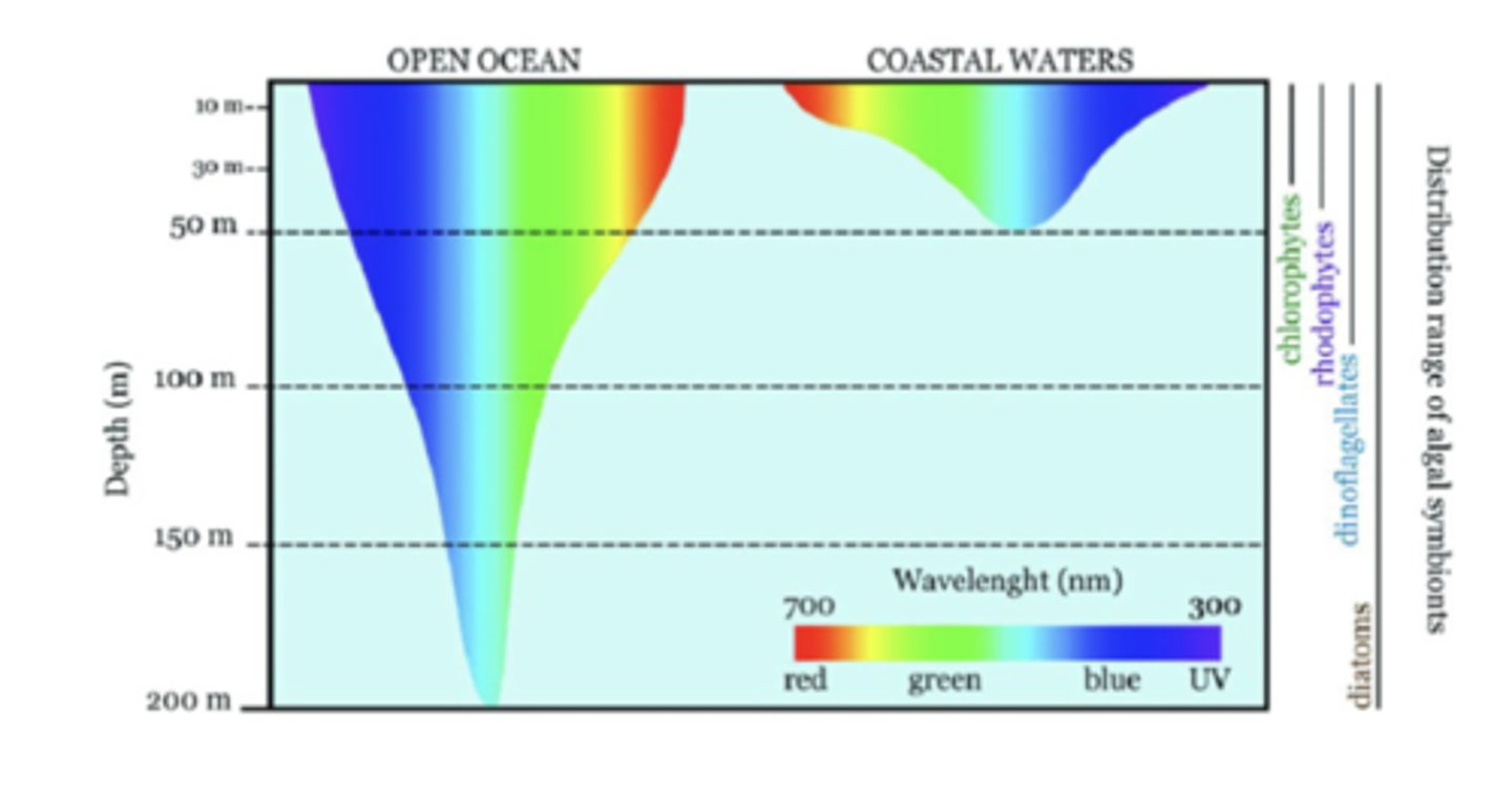
What are algae? How does their ocean depth relate to their light absorption?
Algae are diverse, simple, photosynthetic organisms that range from microscopic single cells to large, multicellular forms like seaweeds; they possess chlorophyll for photosynthesis but lack the complex structures of land plants, such as true roots, stems, and leaves
-different types of algae are adapted to diff light environments and have diff pigments that absorb light of specific wavelengths, corresponding to their depth as light penetration determines where photosynthesis can occur (i.e. chlorophytes absorb red + blue light at shallow depth, rhodophytes absorb blue-green light at mid-depths, dinoflagellates absorb blue/UV light at deep depths, and diatoms vary in preferred light and occupy almost all depth)
What are sea anemones? What organisms do they engage in mutualistic symbiosis with?
Group of predatory marine invertebrate animals related to corals and jellyfish
-sea anemones engage in mutualistic symbiosis with photosynthetic algae, which provides nutrients via photosynthesis while the anemone provides protection and light access, and with clownfish, who get protection from predators while anemones get food scraps and cleaning

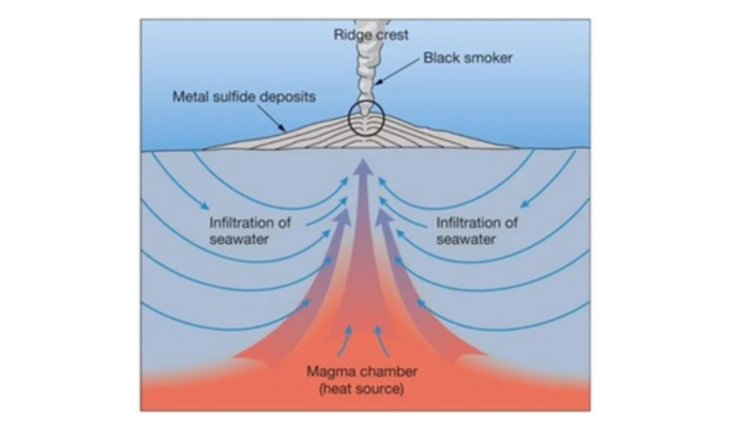
How do deep sea hydrothermal vents form?
When cold seawater seeps into cracks in the ocean floor, is heated by magma in volcanic areas, dissolves minerals from the surrounding rocks, and then rises back to the seafloor as hot, mineral-laden fluid; as this hot, buoyant fluid mixes with the cold surrounding seawater, the dissolved minerals precipitate out, forming mineral deposits that build up into the distinctive chimney-like structures of the vents
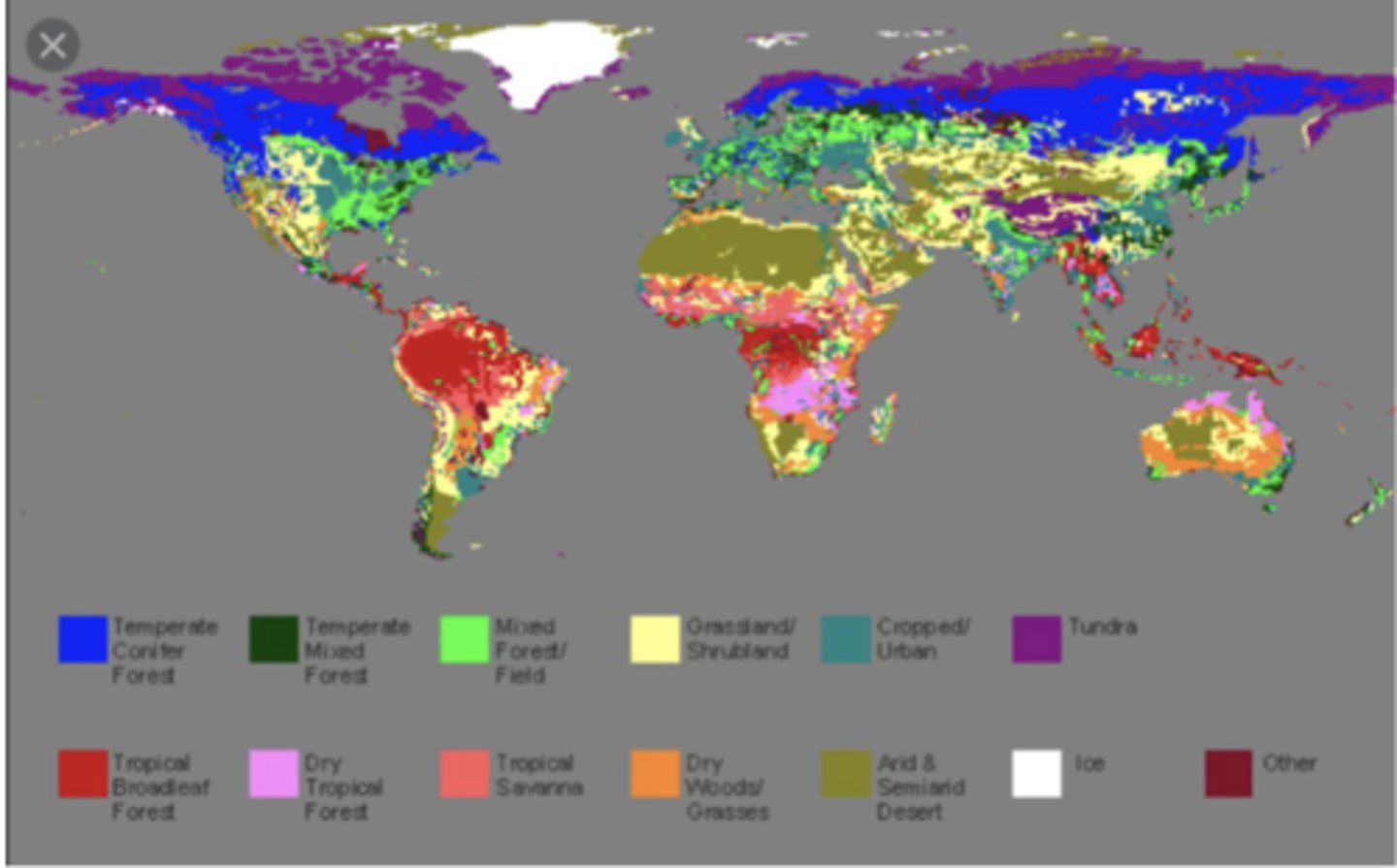
What is a biome? What are the two major determinants of terrestrial biomes?
A distinct geographical region with specific climate, vegetation, and animal life; the two major determinants of a terrestrial biome are temperature and precipitation (high precipitation and warm temperatures support lush tropical wet forests, low precipitation and extreme temperatures result in deserts with low primary productivity, and moderate temperature and precipitation allow for the development of temperate grasslands and forests)
What are Merriam's Life Zones and what are the 6 types? How does environment change with elevation?
The picture shows how biomes change with elevation in Arizona's mountains (called a sky island effect in the desert SW of the US), following Merriam's Life Zones, a system of ecological zones characterized by similar plant and animal life, changing with latitude and elevation due to temperature gradients
1) lower Sonoran zone: desert grassland with cacti, mesquite, etc. and hot, dry climate w little rainfall
2) upper Sonoran zone: desert grassland, oak woodland, chaparral w grasses shrubs and scattered trees, semi-arid conditions which are slightly cooler and wetter
3) transition zone: oak-pine woodland of mixed oaks and pines, moderate temps, more precipitation
4) Canadian zone: Ponderosa pine forest w cool summers, cold winters, and significant snowfall
5) Hudsonian zone: fir forest w cold, moist, long winters and short summers
6) Alpine zone: boreal forest/alpine tundra w stunted trees, alpine meadows, mosses + lichens, and very cold windy conditions
-as elevation increases, temperature decreases, moisture generally increases, and vegetation shifts from desert to forest; this is similar to moving northward across continents: deserts → grasslands → forests → tundra
What is the rain shadow effect and how does it work?
Climatic phenomenon caused by mountains blocking the passage of moist air: prevailing winds blow moist, warm air from the ocean toward the mountains, but as the air moves upward along the windward slope it cools (temperature drops from ~20 °C near sea level to ~-7 °C at ~2000 m altitude), causing its relative humidity to increase
-moisture condenses into clouds and precipitation falls, forming a rainy windward slope; after crossing the mt peak, the air has lost a lot of moisture, however, and so dry air descends the leeward slope, becoming compressed and warming up and ultimately resulting in dry conditions
~this dry region on the leeward side is called the rain shadow; the windward slope is typically lush and wet (forests, agriculture possible), while the leeward slope is much drier, often desert-like (i.e. the dry grasslands east of the Rockies in the US Great Plains)
What is biodiversity? What is the latitudinal biodiversity gradient?
Biodiversity: kinds and numbers of organisms and their interactions
-the general pattern where the number of species, or biodiversity, is highest in tropical regions near the Equator and decreases as you move toward the poles
What qualities characterize the Arctic tundra (i.e. the Arctic Tundra in Canada) in climate, soil, vegetation, animals, daylight cycles, and ecological importance?
Extremely cold temperatures (long winters, very short, cool summers), low precipitation (mostly snow)/technically a cold desert, and strong winds and little sunlight during the winter months (polar night/24 hour darkness in summer)
-permafrost: a permanently frozen layer beneath the surface soil; the active layer (top soil that thaws in summer) is shallow, restricting root growth
-no trees (roots can't penetrate permafrost), so vegetation includes mosses, lichens, sedges, dwarf shrubs, and grasses
-animals are adapted to extreme cold: thick fur, fat layers, migration, or hibernation; examples: caribou/reindeer, Arctic fox, lemmings, snowy owls, musk oxen, polar bears
-stores massive amounts of carbon in frozen soils → sensitive to climate change; warming also causes permafrost thaw, releasing greenhouse gases (CO₂, methane)
What qualities characterize the boreal forest/taiga (i.e. Baniff National Park. Canada) in size, climate, vegetation, soils, animals, and ecological importance?
World's largest terrestrial biome, stretching across North America, Europe, and Asia just south of the Arctic tundra
-long, cold winters and short, mild summers; moderate precipitation
-dominated by coniferous trees (i.e. spruce, pine, fir) with needle-like leaves to reduce water loss and shed snow
-thin, acidic, nutrient-poor soils; permafrost may occur in N taiga, but less widespread than in tundra
-cold-adapted mammals (moose, lynx, wolves)
-acts as major global carbon sink due to massive biomass and soil carbon, but subject to frequent disturbances like wildfires, climate change, logging, and resource extraction
What qualities characterize the deciduous forest in climate, vegetation, soils, animals, and ecological importance?
Four distinct seasons: cold winters, warm summers, and mild spring/fall transitions; moderate to high precipitation, well-distributed throughout the year
-dominated by broadleaf deciduous trees that lose leaves in autumn: oak, maple, beech, hickory, birch, and chestnut; rich understory: shrubs, herbs, mosses, and spring wildflowers
-fertile, nutrient-rich soils
-animals include deer, foxes, black bears, owls, songbirds, etc., many of which hibernate or migrate in winter
-high biodiversity compared to boreal forest or tundra; strongly seasonal cycles in plant growth, animal behavior, and ecosystem processes
What qualities characterize the tropical rain forest in climate, vegetation, soils, animals, and ecological importance?
Hot, humid, and wet year-round; extremely dense and stratified vegetation layers
-generally poor and nutrient-deficient soil despite lush vegetation; nutrients cycle rapidly, as decomposition is fast and nutrients are absorbed almost immediately by plant roots.
~heavy rainfall leaches minerals from soil, making it acidic and infertile for agriculture once forest is cleared
-home to over half of the world's species, making it the most biodiverse biome
-absorbs huge amounts of CO₂ and regulates Earth's climate
What qualities characterize the temperate rain forest (i.e. Olympia National Park, New Zealand) in climate, vegetation, soils, animals, and ecological importance?
Mild temperatures year-round w high precipitation, mostly rain but some snow at higher elevations; cool, wet winters and mild, foggy summers
-tall coniferous trees dominate, often forming old-growth forests
-nutrient-rich soils, as cool, moist conditions slow decomposition
-lower species diversity than tropical rainforest, but still rich in wildlife
-stores huge amounts of biomass and carbon, provides critical habitat for species adapted to cool, wet conditions, regulates water cycles (fog and rainfall keep rivers flowing steadily), and supports fisheries and human communities

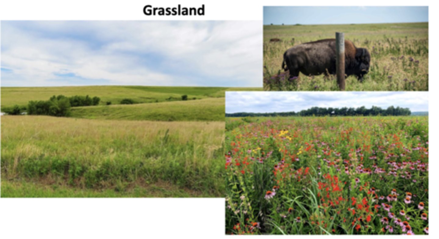
What qualities characterize the grasslands/prairies (i.e. Missouri glades) in climate, vegetation, soils, animals, and ecological importance?
Moderate rainfall, often have seasonal extremes: cold winters & hot summers (temperate grasslands) or distinct wet and dry seasons (savannas)
-dominated by grasses adapted to fire and grazing; few trees due to insufficient rainfall, frequent fires, and grazing pressure
-some of the richest, most fertile soils in the world, which is why many grasslands have been converted to farmland (like in the middle of the US)
-large grazing herbivores dominate, but also has large predators, birds, and burrowing animals
-serve as major carbon sinks through deep-rooted grasses, support migratory species and large herds that maintain ecosystem balance, and fire and grazing cycles prevent forests from overtaking grasslands
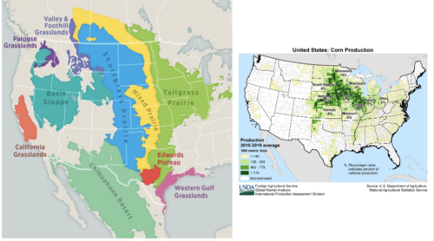
Distribution of Biomes in the Western US
Picture
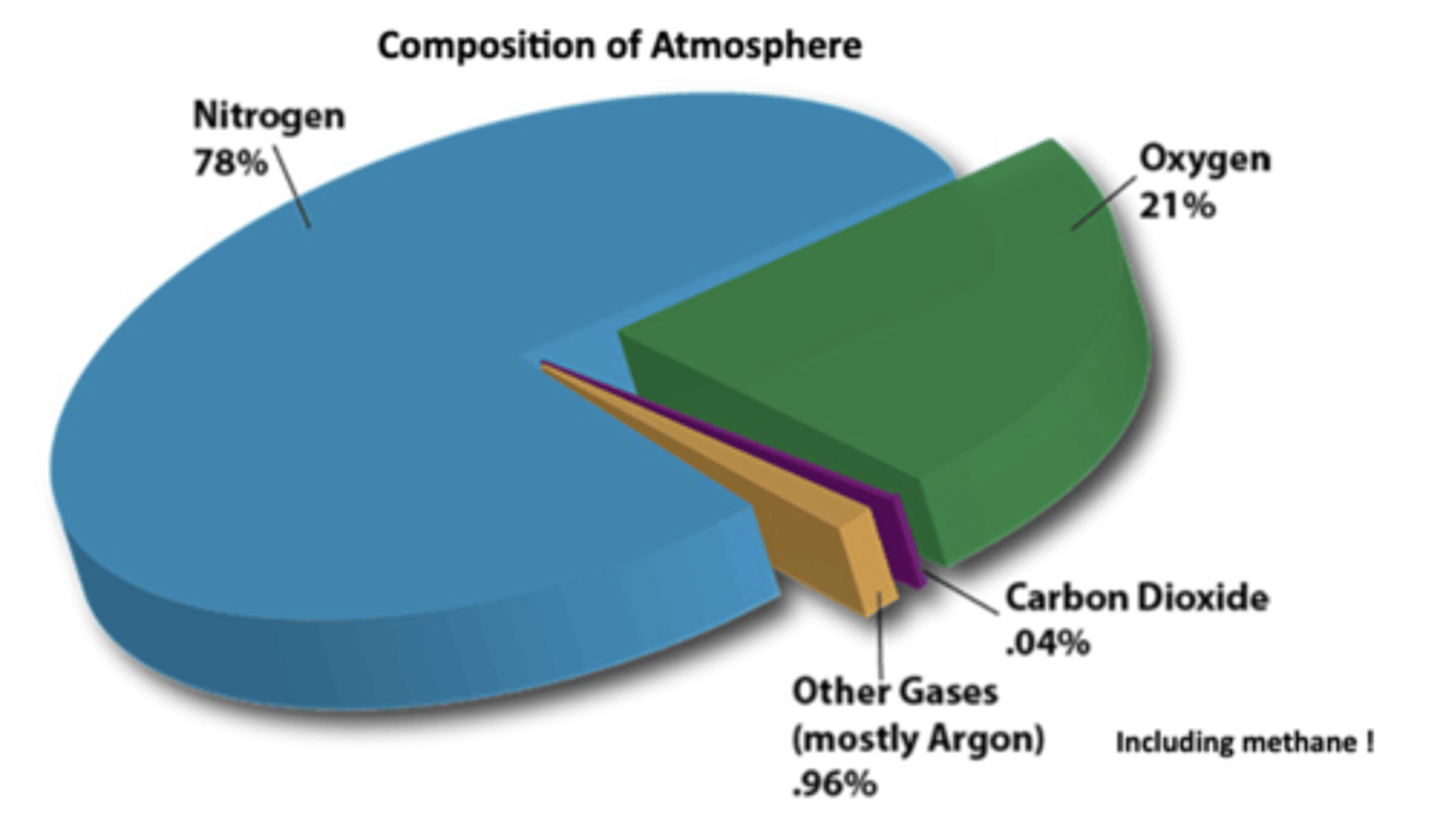
What are the 3 major gases which make up the atmosphere?
Nitrogen, oxygen, and CO2
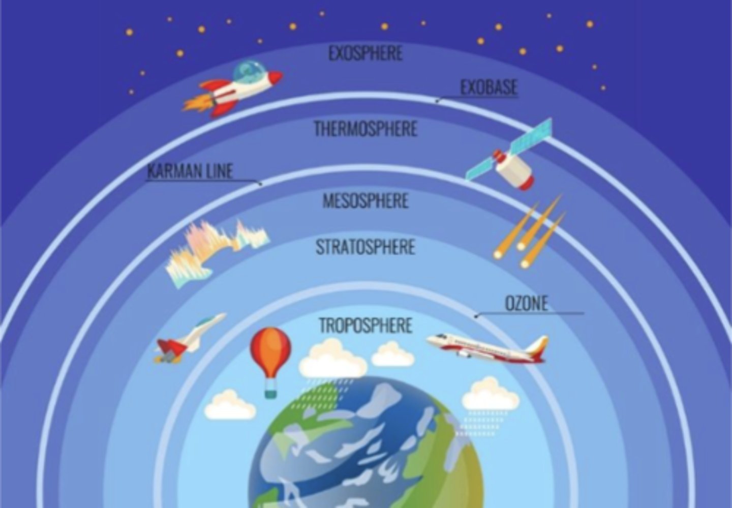
What are the 5 layers of the atmosphere?
Troposphere, Stratosphere, Mesosphere, Thermosphere, and Exosphere
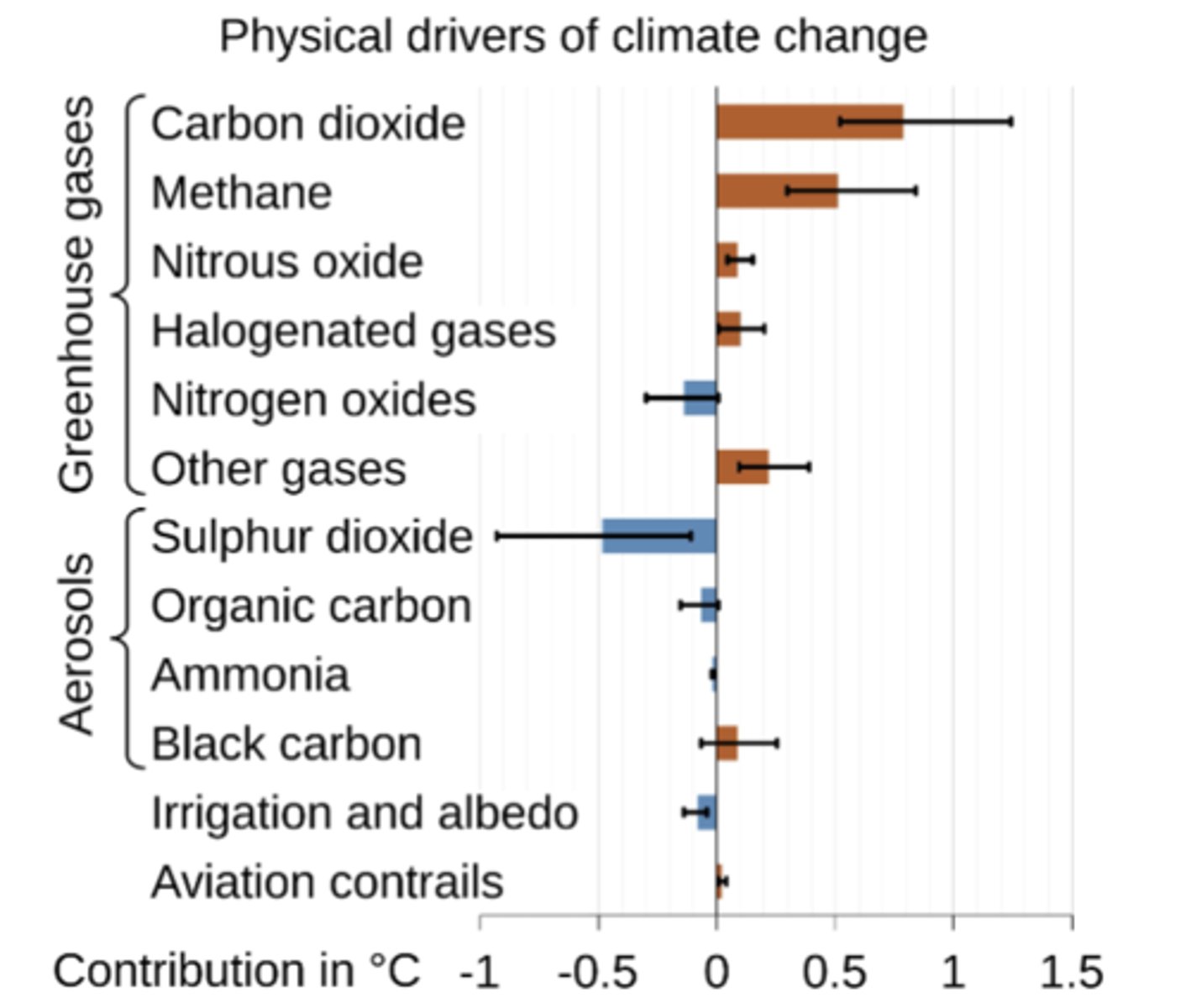
What are greenhouse gases vs aerosols? What are the most effective GHGs and aerosols?
Greenhouse gases are gases in the atmosphere that absorb and emit infrared radiation, trapping heat and causing the planet to warm, while aerosols are tiny solid or liquid particles suspended in the air, which can scatter sunlight back into space, producing a net cooling effect, but can also absorb it, warming the planet
-CO2 and methane have largest GHG effects while sulphur dioxide has large effect in reducing global temperatures
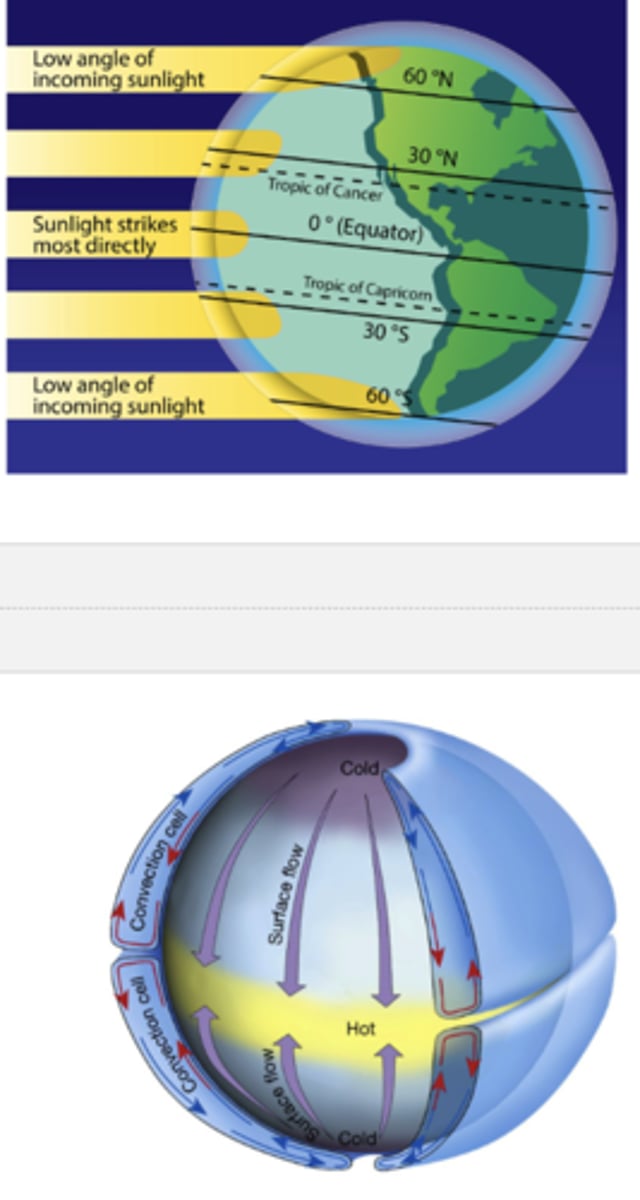
Why does Earth have different climate zones and wind circulation patterns?
The earth is curved so sunlight hits diff parts at diff angles (i.e. more directly at equator, least at the poles); the Tropics of Cancer and Capricorn mark the limits of the sun's direct overhead rays during solstices
-because the equator is hotter than the poles, warm air rises at the equator and cooler air sinks at higher latitudes, creating convection cells
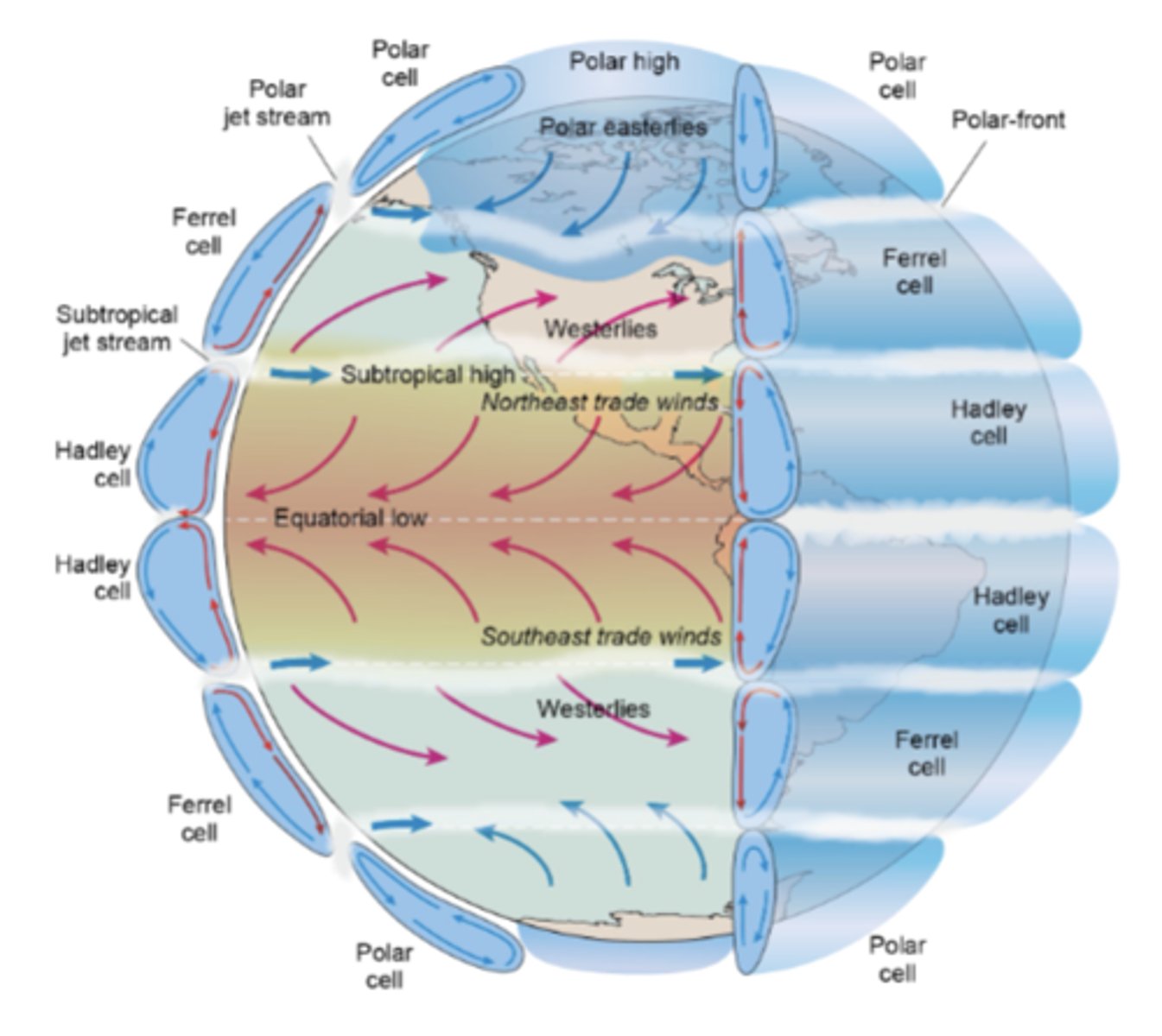
What are the three major circulation cells per hemisphere?
Hadley cell (closest to equator), Ferrel cell (mid), polar cell (close to poles)
-at the equator, warm air rises → creates low pressure → air cools, moisture condenses → heavy rainfall; around 30 degrees N and S, the rising air from the equator spreads out and sinks here, where it is dry → creates deserts
-around 60 degrees N and S, air rises again due to mixing with cold polar air → leads to precipitation → temperate forests often found here; at the poles, cold, dense air sinks → very dry → polar deserts
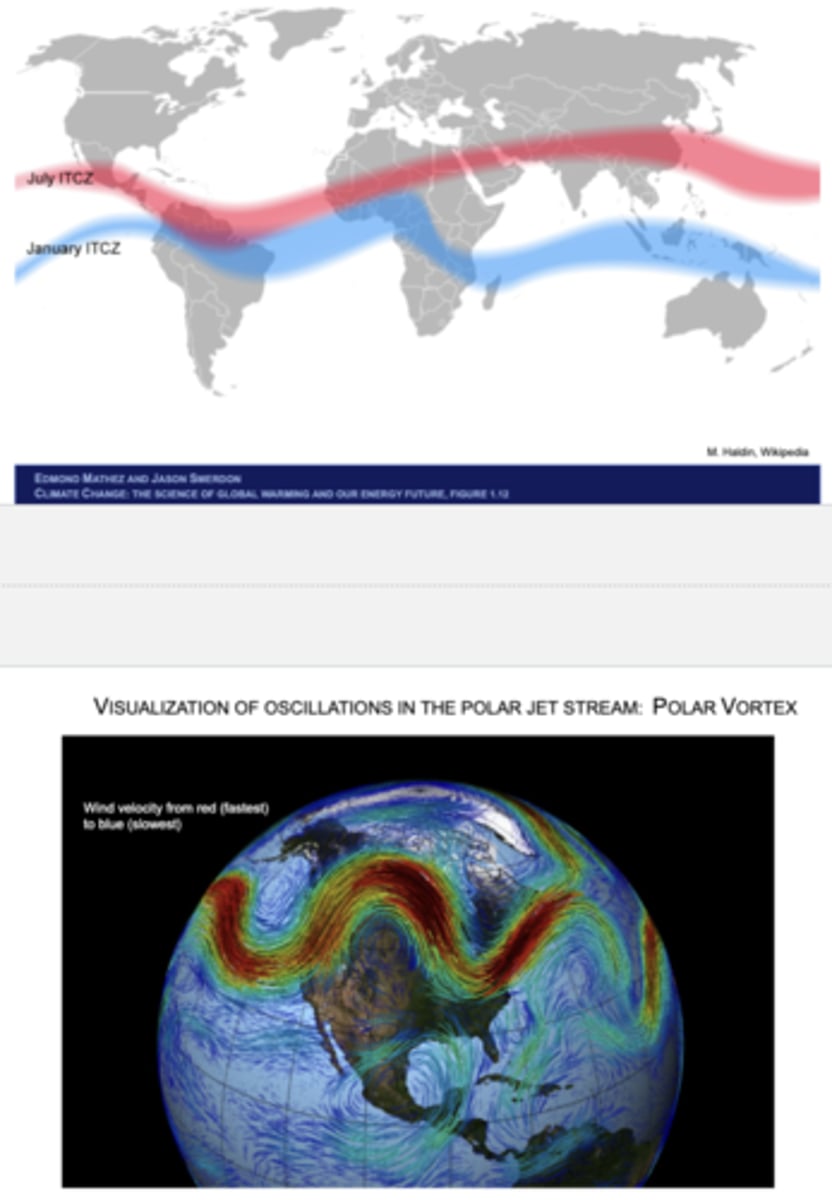
What is the intertropical convergence zone (ITCZ)? How does it shift with the seasons? What is the polar jet stream and how does it oscillate? What is the polar vortex and how does it affect the polar jet stream? How might they both be affected by climate change?
The ITCZ is the belt of low pressure near the equator where the trade winds from both hemispheres converge, associated with rising warm air, heavy cloud formation, and rainfall
-moves northward when the N hemisphere is tilted toward the Sun (during the summer), bringing monsoon rains to places like India, W Africa, and Central America; moves southward during Southern Hemisphere summer, bringing rains to Brazil, S Africa, and N Australia
-with climate change, shifts may intensify rainfall variability (wetter wet seasons, drier dry seasons)
The polar jet stream is a high-speed, fast-flowing river of air in the upper atmosphere that circles the globe from west to east, separating cold polar air from warmer mid-latitude air
-meanders in large waves called Rossby waves; the polar vortex refers to the large-scale low-pressure system that surrounds the poles in the stratosphere and troposphere: when the vortex is strong, the jet stream tends to be stable and circular, keeping cold Arctic air contained, but when weak the jet stream becomes more wavy and unstable, allowing cold Arctic air to spill southward (causing severe winter storms in mid-latitudes) and warm air to move northward
-may become more unstable due to amplified Arctic warming, leading to more frequent extreme weather events
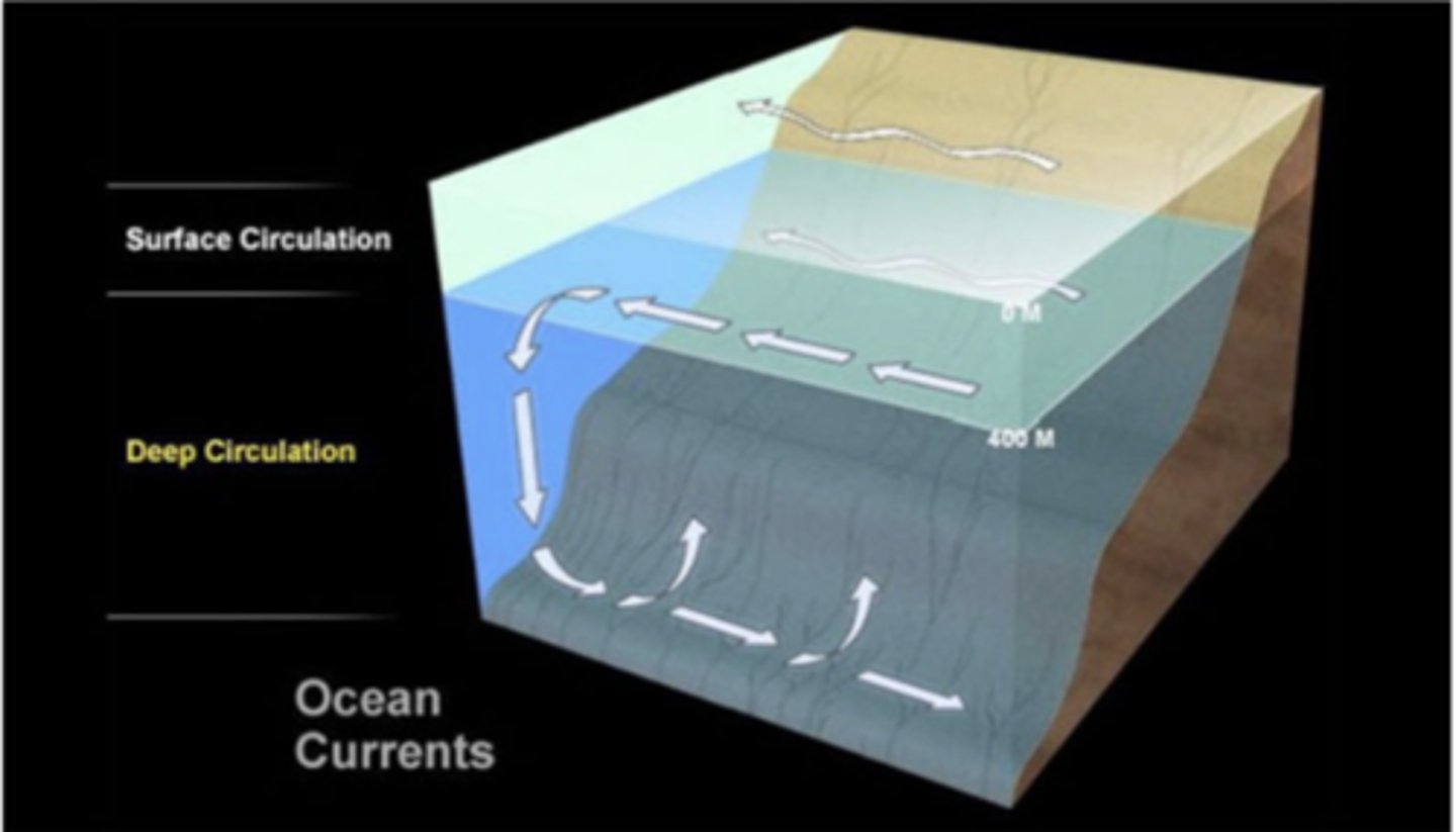
How much of the Earth is covered by oceans? How are global patterns of water temperature shaped by sunlight? How are surface and deep water circulation responsible for global ocean currents?
71% of Earth's surface is ocean-covered
-near equator, sun is more direct year-round -> warm surface temperatures, while toward the poles it's weaker -> cold surface waters; seasonally, surface water temperatures follow cycles (warmer in summer and cooler in winter), especially in mid-latitudes
-surface circulation is driven primarily by wind and the Coriolis effect (described on next slide), forming large gyres (rotating systems of currents) in oceans like the Gulf Stream in the Atlantic, moving warm water from the equator toward the poles and cooler water back toward the equator; deep circulation, meanwhile, is driven by density diffs which depend on temperature and salinity: cold salty water is denser (while warm low salinity water is much lighter) and sinks in high-latitude regions, flowing along the sea floor and eventually rising/upswelling in other regions
~together these form the global conveyer belt of ocean circulation: surface currents bring warm water poleward, water cools, becomes saltier (through evaporation or ice formation), sinks, and joins the deep circulation, then deep water eventually upwells, bringing nutrients back to the surface
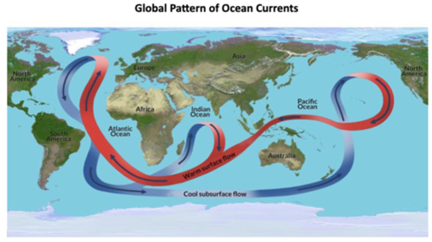
What is the Coriolis effect and how does it differentially affect the temperature of sides of oceans?
The Coriolis effect, caused by earth's rotation, deflects moving water right in the N hemisphere and left in the S hemisphere, thus organizing ocean currents into gyres: warm western boundary currents (e.g., Gulf Stream) carry warm water towards the poles while cold eastern boundary currents (e.g. California Current) carry cold water towards equator; results in W sides of oceans being warmer and E sides being cooler
-together with the aforementioned aspects forms global ocean currents
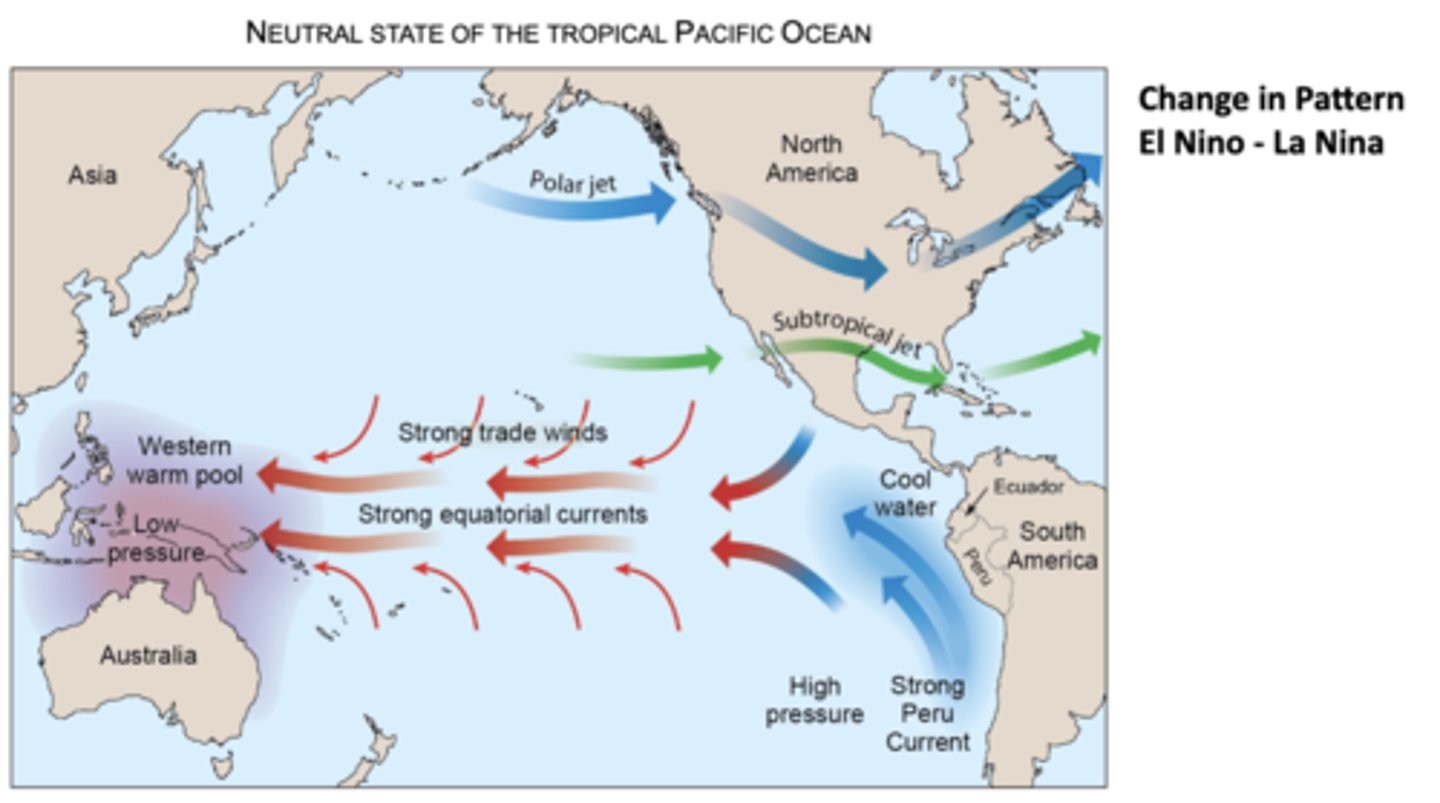
What does the neutral state of water flow in the tropical Pacific look like and how does it give rise to different conditions in the E and W Pacific? What are El Niño, La Niña, and El Niño-Southern Oscillation and how do they alter these conditions?
The neutral state of the tropical Pacific has strong trade winds and equatorial currents which push warm surface water West towards Australia and Indonesia; accumulation of warm water here creates a low-pressure zone which encourages rising air and thunderstorms (warm and rainy conditions), while on the Eastern Pacific coolers waters upwell near Peru and Ecuador, supported by the Peru Current, to create high pressure and drier conditions (cooler and drier conditions)
-meanwhile, polar jet and subtropical jet influence weather patterns over NA
-El Niño and La Niña are part of a larger climate cycle called the El Niño-Southern Oscillation (ENSO); during El Niño, trade winds weaken or even reverse, causing warm water in the west to move eastward towards SA and bringing warm, wet conditions to the E Pacific while Australia/Indonesia experience drier conditions
~La Niña is the opposite: trade winds strengthen even more and warm water is pushed farther W, making the W pacific extra warm and wet and the East Pacific even cooler than normal; intensifies "normal" patterns of floods in Asia/Australia, drought in SA, and changes in jet stream paths
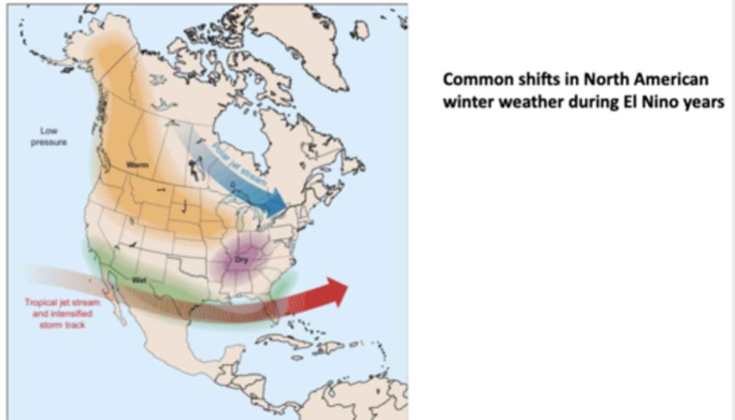
What are the common shifts in NA winter weather during El Niño years? Why?
Tropical jet stream strengthens and shifts eastward, bringing more storms and rainfall across the S US (CA, TX, FL, Gulf Coast), meaning the S tier of the US typically gets wetter-than-normal winters; meanwhile, parts of the Ohio Valley and Midwest often experience drier-than-normal winters
-much of Canada and the N US tends to have warmer-than-normal winters bc the polar jet stream shifts N, preventing as much Arctic air from dipping S
-at the same time, over the N Pacific a low-pressure area develops, reinforcing the altered jet stream paths
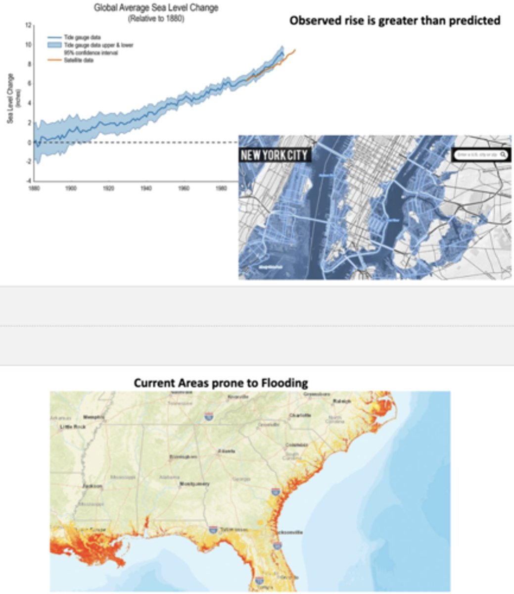
How has global average sea level changed since 1980? How has it changed and is projected to change on the Florida coasts?
Risen significantly, ~9 inches since 1880 by 2022, which is greater than predicted; coastal levels in Florida have risen 8 inches from 1950, and the rate of rise is increasing such that by 2050 it will be ~1 ft
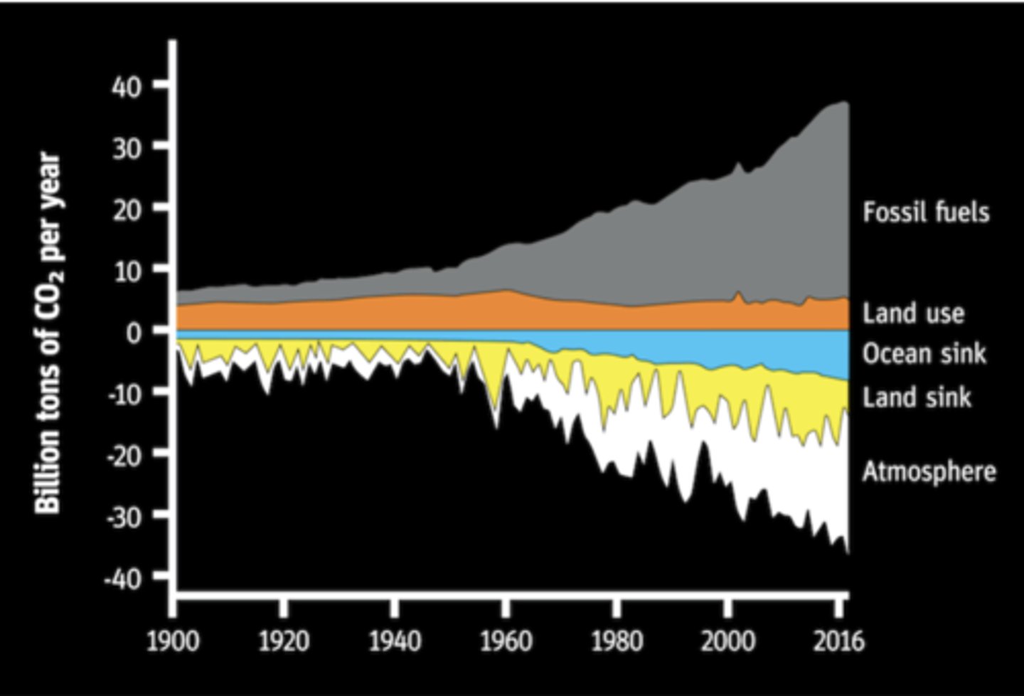
How has atmospheric CO2 released and absorbed changed since 1900?
Fossil fuel emissions have increased dramatically since 1950 and comprise far and away the largest CO2 emissions annually, primarily absorbed into the atmosphere though partially by land and ocean sinks
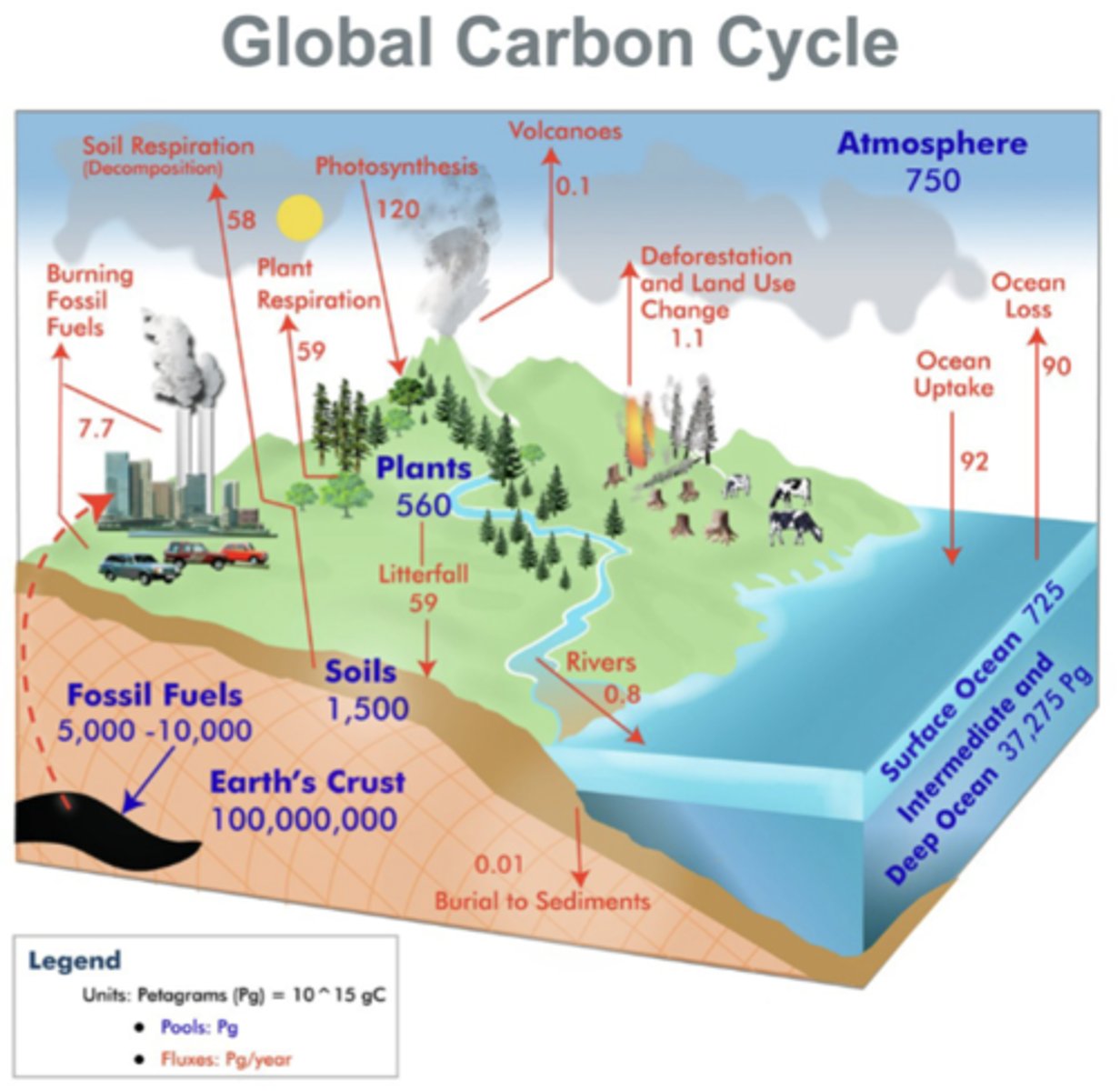
What are the components of the Global Carbon Cycle?
The atmosphere contains carbon mainly as CO2, exchanging carbon with plants, soil, and oceans; contains ab 750 petagram (10^15 grams C, abbreviated as Pg)
-plants take in CO2 through photosynthesis, release CO2 back into the atmosphere through plant respiration, and contribute carbon to soils via litterfall
-soils store large amounts of C in organic matter and release CO2 via soil respiration/decomposition
-fossil fuels are a massive long-term carbon reservoir (5,000-10,000 Pg), but human burning of fossil fuel adds C to the atmosphere
-earth's crust is the largest C reservoir, locked in rocks and sediments; has very slow fluxes through volcanoes and burial to lower sediments
-the ocean (mostly the deep ocean) also holds immense amounts of C; exchanges C with the atmosphere but has a net effect as a carbon sink
-deforestation and burning fossil fuels are major contributors to rising atmospheric CO2
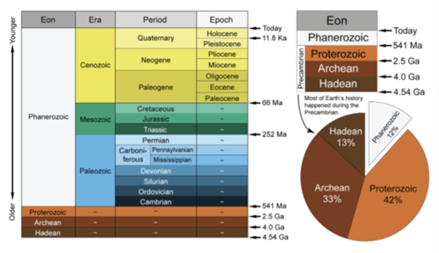
The Eons, Eras, Periods, and Epochs of Earth's History
Picture
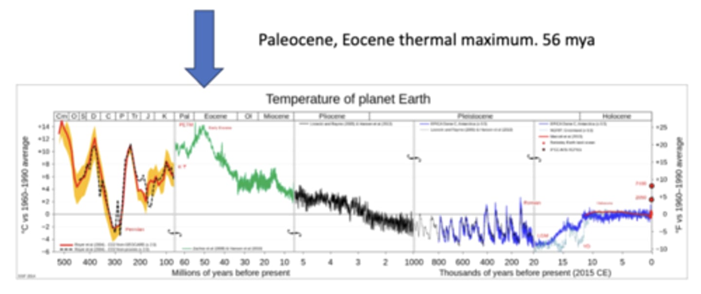
In what part of earth's history has its temperature been most volatile? When did it reach its thermal maximum?
Most volatile from the Cambrian to the end of the Miocene; reached a major thermal maximum around 56 million years ago during a period known as the Paleocene-Eocene Thermal Maximum
-despite not exhibiting these shifts, climate change today is still concerning despite past dramatic shifts because the current warming is happening at an unprecedented rate, far faster than most past natural changes, making it difficult for humans and ecosystems to adapt
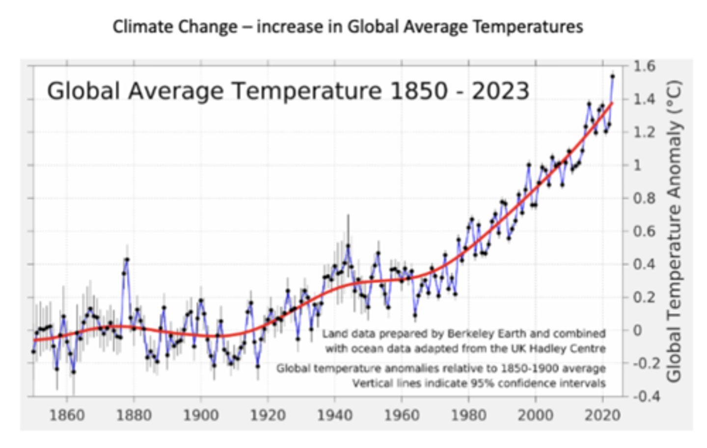
Global Average Temperature 1850-2023
Pictured
How have ice sheets from Antarctica and Greenland been critical in determining atmospheric composition of the past?
The image shows a piece of ice core drilled from deep within the Greenland Ice Sheet, and the white specks inside are tiny air bubbles trapped when the snow originally fell and compacted into ice; the gases inside (like CO₂, CH₄, and N₂O) reflect the atmosphere at the time the snow fell
-by measuring the concentration of these gases, scientists can reconstruct past climates and greenhouse gas levels going back hundreds of thousands of years; data from Greenland and Antarctica ice cores prove that modern CO₂ levels are far higher than at any point in the last 800,000 years
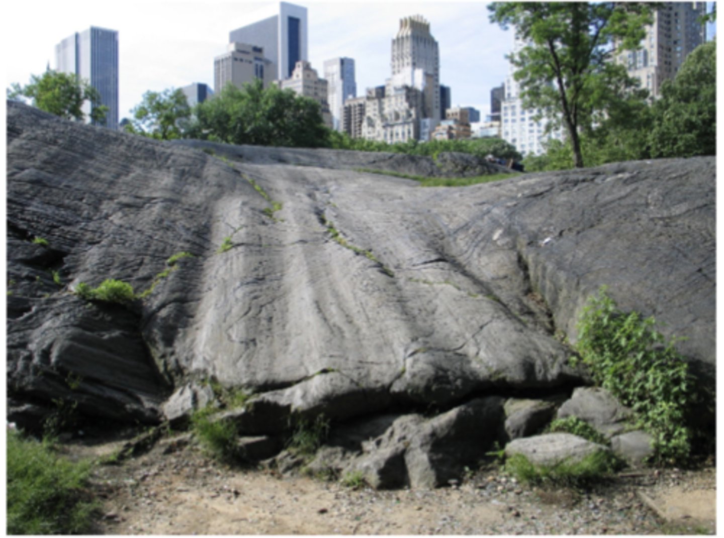
What are glacial striations?
Long, parallel scratches or grooves in rock formed when a glacier moved across the land, dragging rocks, gravel, and ice at its base which show the direction of ice flow; for ex, the striations in Central Park were left by the Laurentide Ice Sheet during the last Ice Age
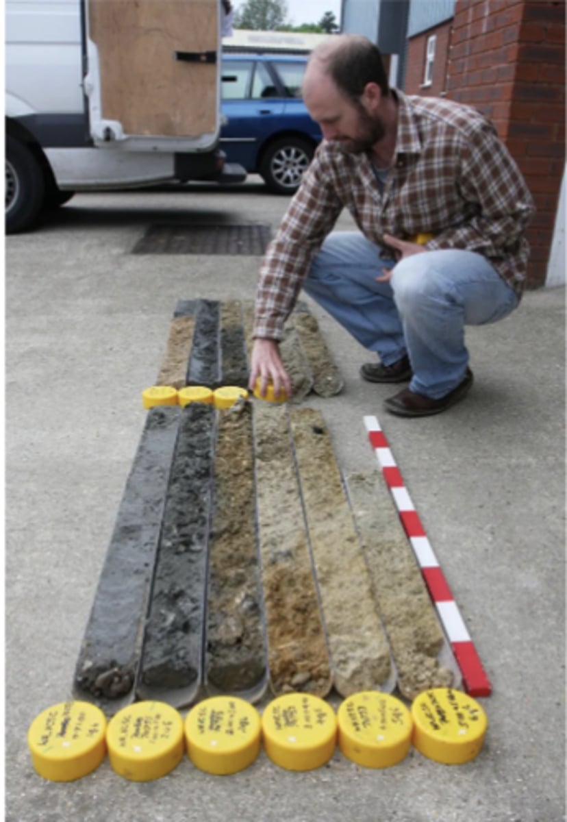
What are sea bottom cores and how are they used to reconstruct Earth's past atmosphere and climate?
Sea bottom cores are long cylinders of sediment drilled from the ocean floor; each layer is like a page in Earth's history book, preserving information about past conditions, and sediment cores can extend much further back in time than ice cores
-shifts in ^13C isotopes show past changes in atmospheric CO2 and global C cycling
-microfossils of tiny marine organisms have variant oxygen isotope ratios, reflecting ocean temp and ice volume at the time they lived (more ^18O -> colder periods, more ice)
-ratios of trace metals like Mg/Ca or Cd/Ca in shells reflect seawater properties, which link to atmospheric CO2 levels
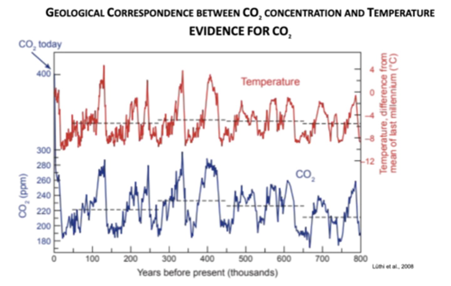
How are CO2 and temperature correlated over earth's history? How has the CO2 level changed in present day?
Over glacial-interglacial cycles, when CO₂ levels are high, temperatures are high; there is a tight coupling of CO2 and temperature, strong evidence that CO2 is a major driver of global climate change
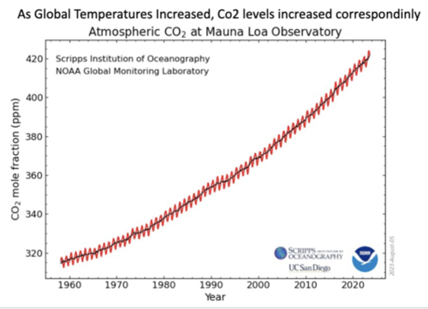
-for 800,000 years, CO₂ stayed between ~180 ppm (ice ages) and ~300 ppm (warm periods), with cycles controlled by orbital variations, feedbacks, and C cycle shifts; human activities (fossil fuel burning, deforestation) have pushed CO₂ above 400 ppm, a level not seen in this entire record
How has the atmosphere changed due to increased CO2 levels?
-caused the Earth's temperature to rise through the enhanced greenhouse effect, leading to global warming and subsequent impacts such as melting ice, sea-level rise, changes in rainfall patterns, and increased frequency and intensity of extreme weather events
-rise in CO2 also results in ocean acidification
-atmosphere has also experienced structural changes, such as the contraction of the upper atmosphere due to the cooling effect of extra CO2
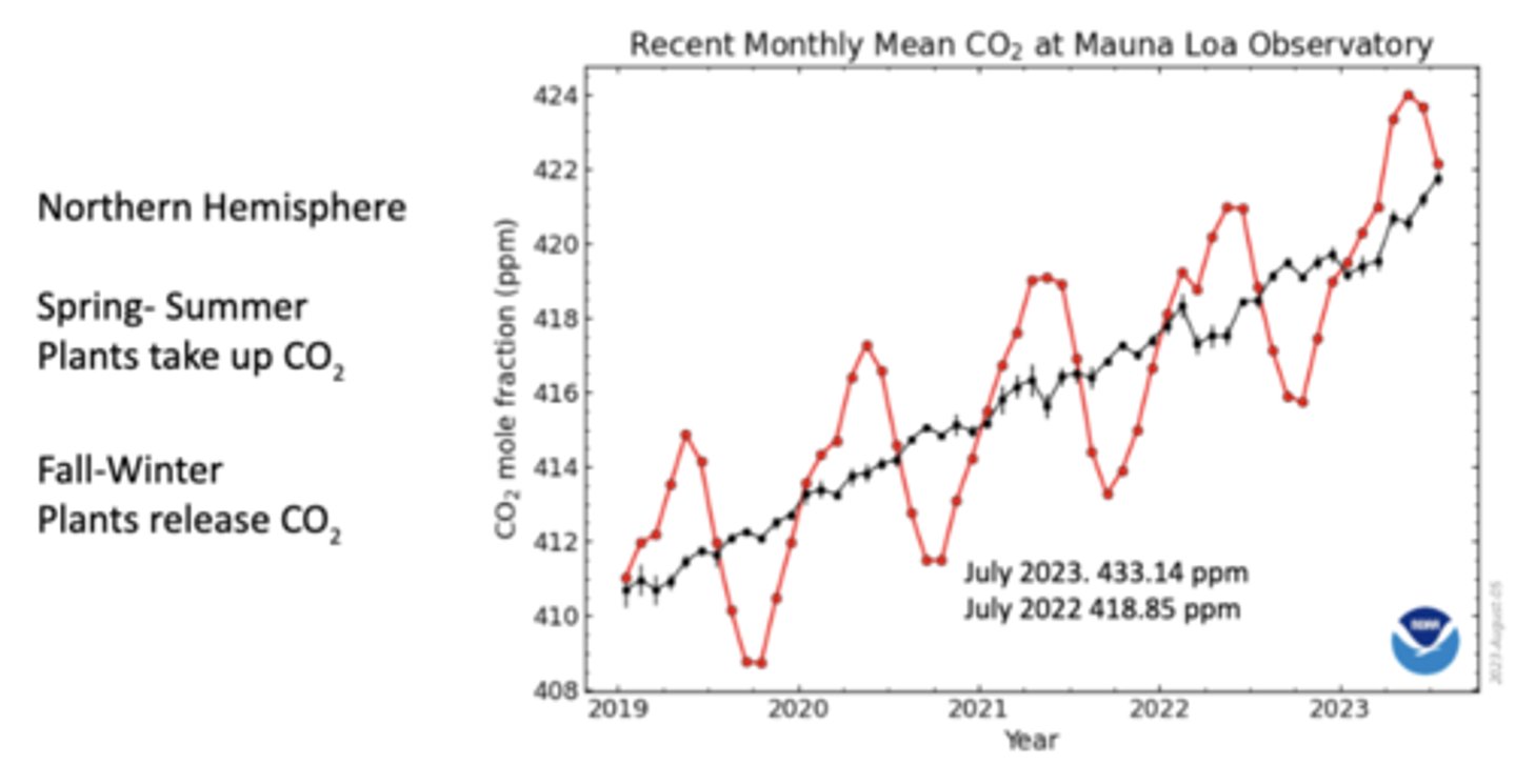
How do atmospheric CO2 concentrations change by season and why?
In the Northern Hemisphere spring and summer, plants grow and photosynthesize, absorbing CO₂ from the atmosphere and causing CO₂ levels to dip; in the fall and winter, plants die back or go dormant, and decomposition releases CO₂ back into the air, causing CO₂ levels to rise
-since most of Earth's land (and plants) are in the Northern Hemisphere, this seasonal plant cycle is very noticeable globally
-still a long-term upward trend
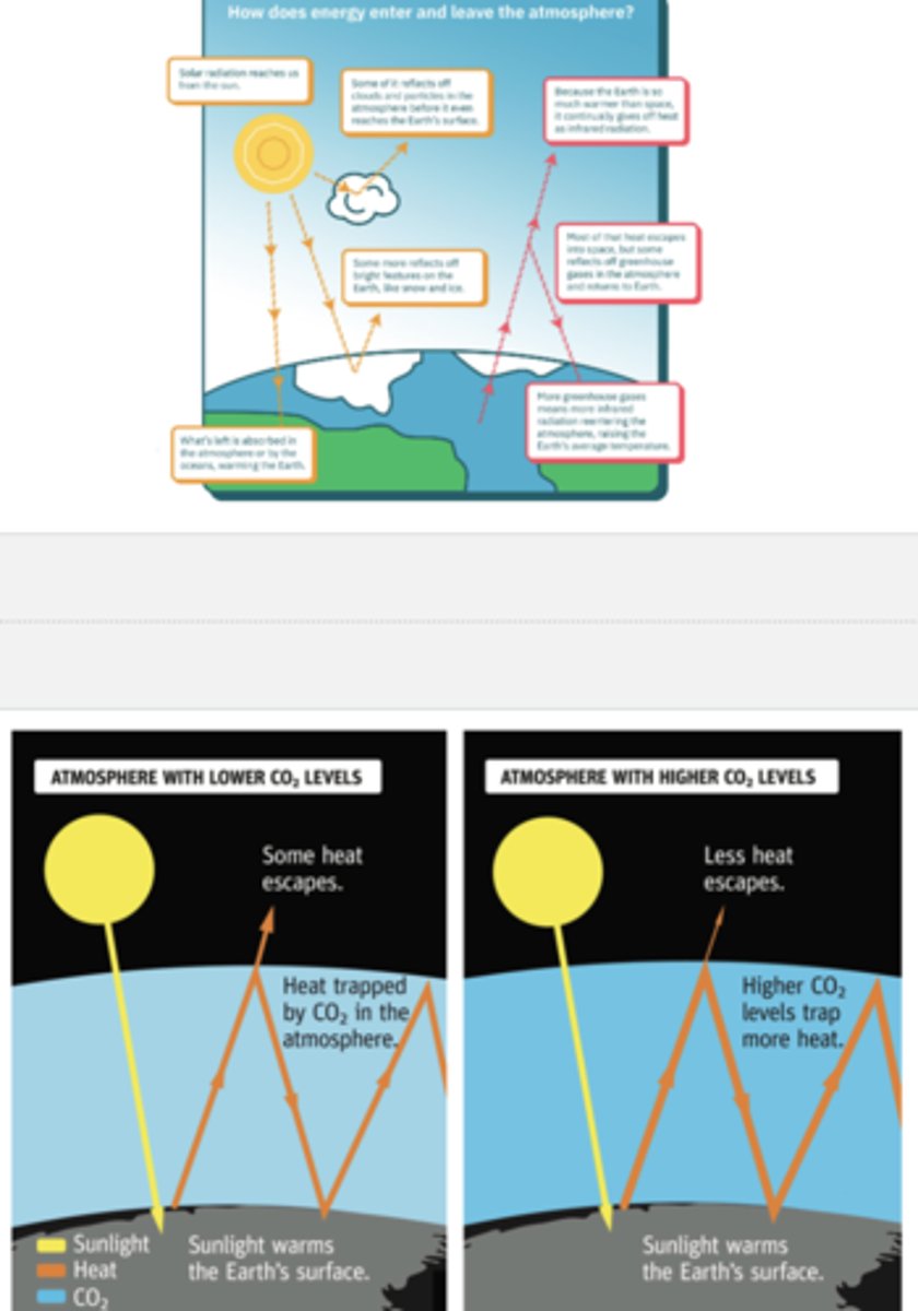
How does the greenhouse effect warm the globe?
Sunlight reaches earth; some is reflected by clouds, dust, and particles in the atmosphere, some is reflected by bright Earth surfaces, and the rest is absorbed by Earth's surface, warming the planet
-bc earth is warmer than space, it emits heat (infrared radiation) back outward; most heat escapes into space, but some is trapped and reflected back by greenhouse gases (CO2, CH3, H2O vapor), so higher levels correlate with higher temperature
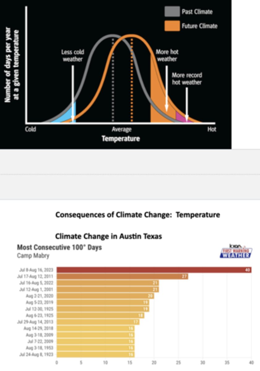
How is future climate projected to shift in temperature? How does this correlate to extreme weather?
Future climate is projected to have fewer cold days, more hot days, and higher frequency and intensity of extreme heat; for ex, in Austin, Texas, many of the longest heat streaks on record are in recent decades, and a streak in 2023 holds the record
-slight shifts in mean temperature can result in increases of extreme weather
Some climate change deniers claim droughts have no increase in duration of magnitude going back to 1900, no overall increase in wildfires (and actually a decline over recent decades), no long-term trends in hurricanes going back to 1980, and no increase in flood risk (and actually a decline globally). Are these claims true?
-the claim about droughts are false: some regions show increases in extreme drought frequency or severity, others don't; the scientific literature (i.e. IPCC reports) indicates climate change is increasing the risk of more intense and longer droughts in many places
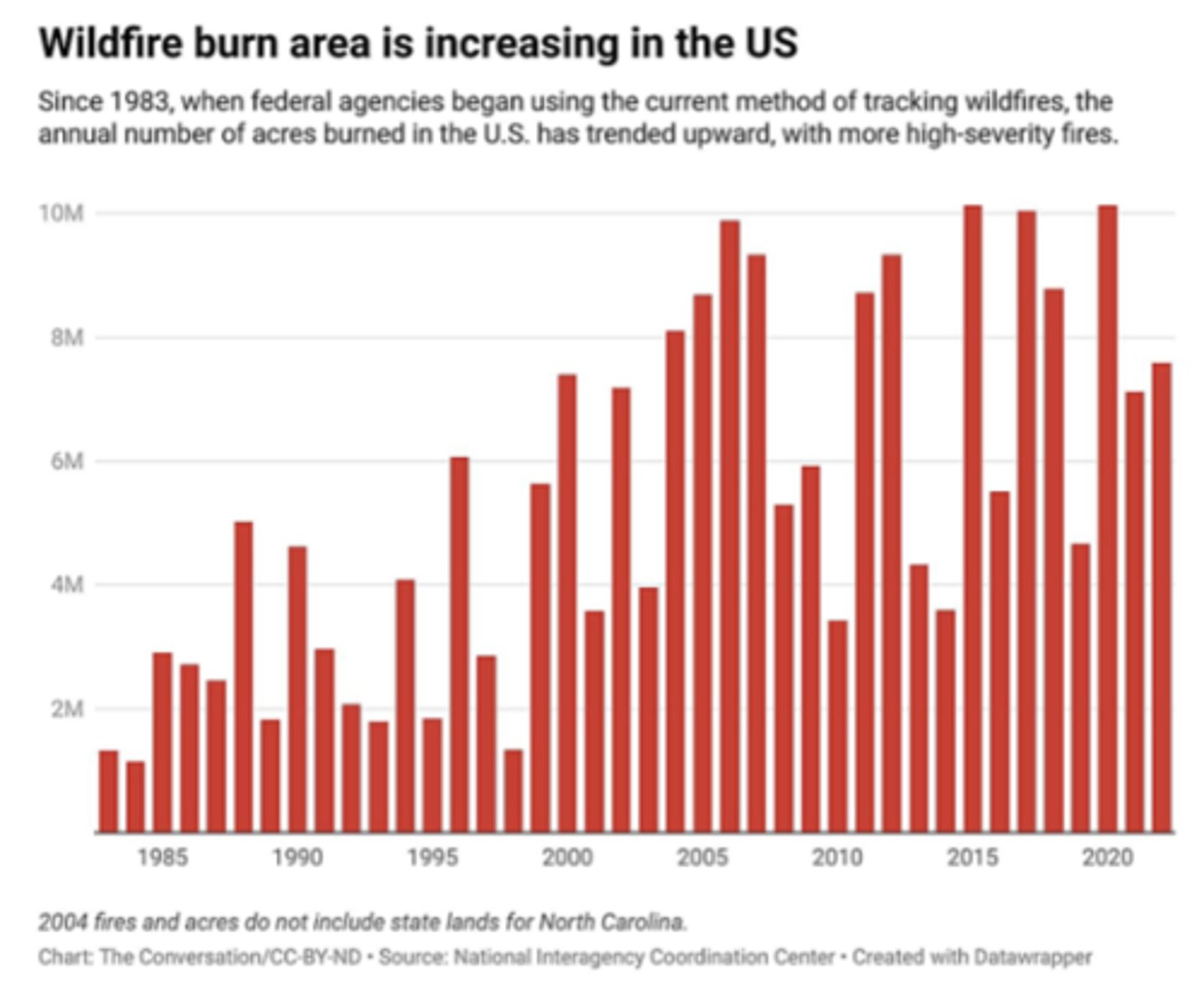
-the claim about wildfires is partially true in some cases, but misleading globally: global data shows burned area from wildfires had declined in recent decades, especially due to less burning in savannas and shrublands, but forest fires in some regions (i.e., parts of W North America, Australia) have increased in several metrics (intensity, severity, fire season length) and caused greater damage
~some studies note that while total global fire area has gone down, changes in forest fire behavior (more severe burns, more large fires) mean impacts are still increasing
-the claim about hurricanes are not accurate: there is evidence for increasing intensity of tropical cyclones in many basins, especially more frequent very intense storms (Category 4/5) and more rapid intensification; trends in overall frequency (number of storms) are mixed or weak in some places (some basins show increases, others don't)
~detection biases complicate older records; improvements in observation (satellites, better sensors) mean more storms are detected now than a few decades ago, which can skew number of storms trends
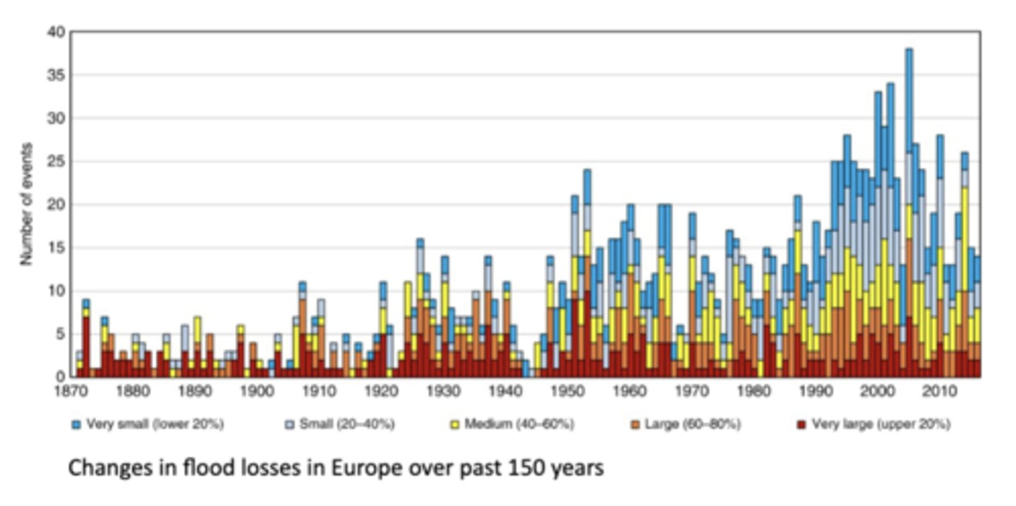
-the claim about flooding is false: risk of flooding is increasing in many parts of the world due to changes in precipitation extremes, economic costs of flooding are going up, and globally evidence suggests frequency/intensity is increasing in many river basins especially in Asia, Africa, parts of Europe, etc.
~flood mortality has declined in many places thanks to improved warning, infrastructure, etc, but that doesn't mean flood hazard is declining
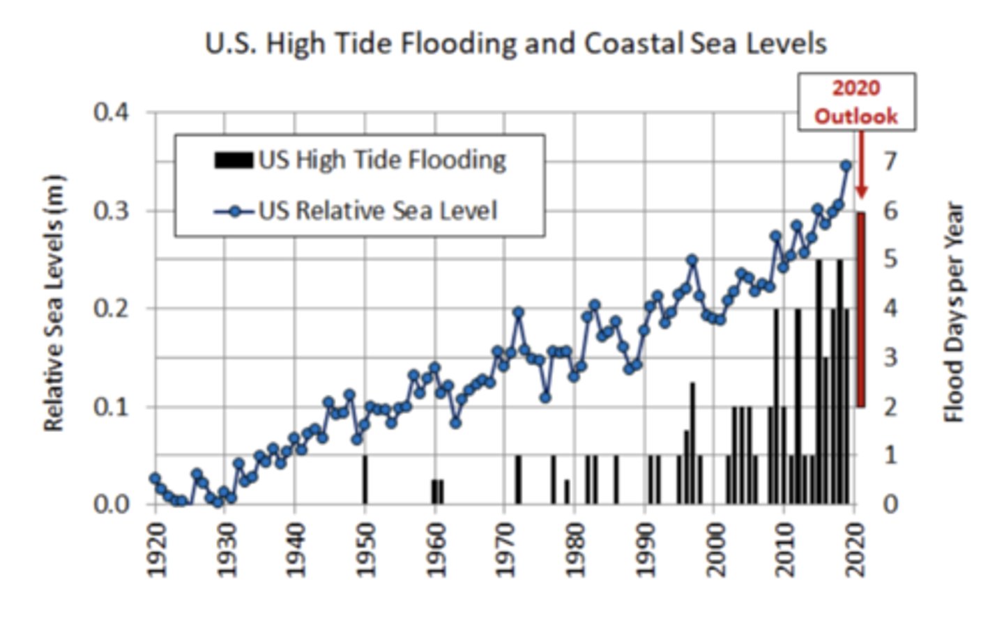
US High Tide Flooding and Coastal Sea Levels
Picture
Wildfire Burn Area in the US
Picture
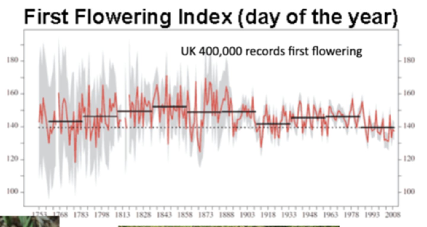
How has flowering in the UK changed over time with climate change?
The graph shows the day of the year when plants first flower, based on 400,000 records from the UK; the red line is yearly flowering dates and the gray bands are the uncertainty range
-over time, flowering is happening earlier in the year (the index has shifted from ~150 days into the year toward ~140), presenting evidence that warming temperatures are altering the timing of biological events (phenology)
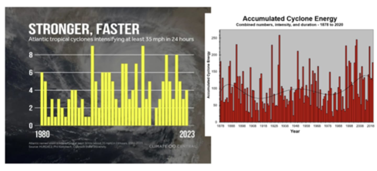
Atlantic Tropical Cyclone Energy Trends
Pictured
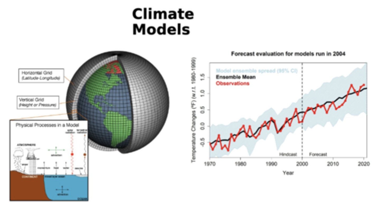
What is the grid system involved in climate models and how is it used? How have climate models for temperature change compared to actual observed changes over the past 50 years?
The earth is divided into a 3D grid: horizontal grid (latitude-longitude) slices the earth's surface into grid cells and the vertical grid (height or pressure) divides the atmosphere and ocean vertically; within each grid cell, climate models simulate important physical processes like radiation, evaporation and condensation, cloud formation, ocean currents and mixing, and carbon cycle, allowing model to represent how energy and matter flow through earth's climate system
-the rightmost graph shows how well climate models perform when compared to actual data, showing they perform well and validating them as reliable tools for understanding and forecasting global warming
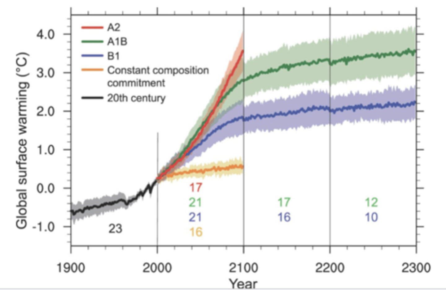
How is global warming expected to progress under high, medium, and low emissions scenarios in the coming centuries?
The black line represents historical temperature changes up to ~2000; the red (A2) line represents a high emissions scenario, leading to the highest warming, the green (A1B) to a medium emissions scenario leading to mid-range warming, the blue (B1) to a low emissions scenario leading to lowest warming, and the orange (constant composition commitment) to a hypothetical case where greenhouse gases are frozen at the year 2000's levels showing the warming would still happen due to inertia in the climate system
-shows past warming is real and well captured and that future warming depends on emissions (using climate models)
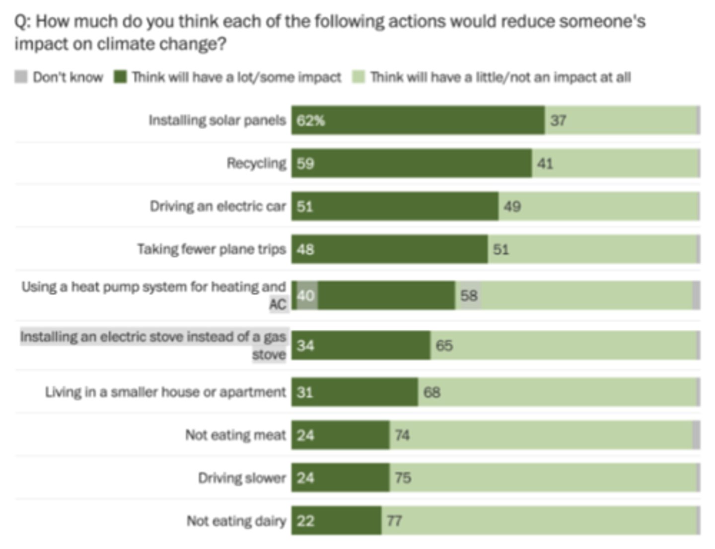
How do peoples' perspectives on how they can make decisions to impact climate change compare to reality?
This chart reveals a gap between public perception and scientific evidence; people think the biggest impacts come from installing solar panels, recycling, and driving an electric car and the smaller impacts come from not eating meat, not eating dairy, and living in a smaller house/apartment
-studies suggest the most impactful individual actions are having fewer children (by far the largest lifetime impact), living car-free/reducing air travel, and eating a plant-based diet; moderate-impact actions include switching to an EV, installing heat pumps for heating/cooling, and improving home energy efficiency
~low impact actions include recycling, driving slower, and switching stoves (gas -> electric); recycling and solar panels are overestimated by the public, diet changes and flying less are underestimated, and electric cars and heat pumps do matter
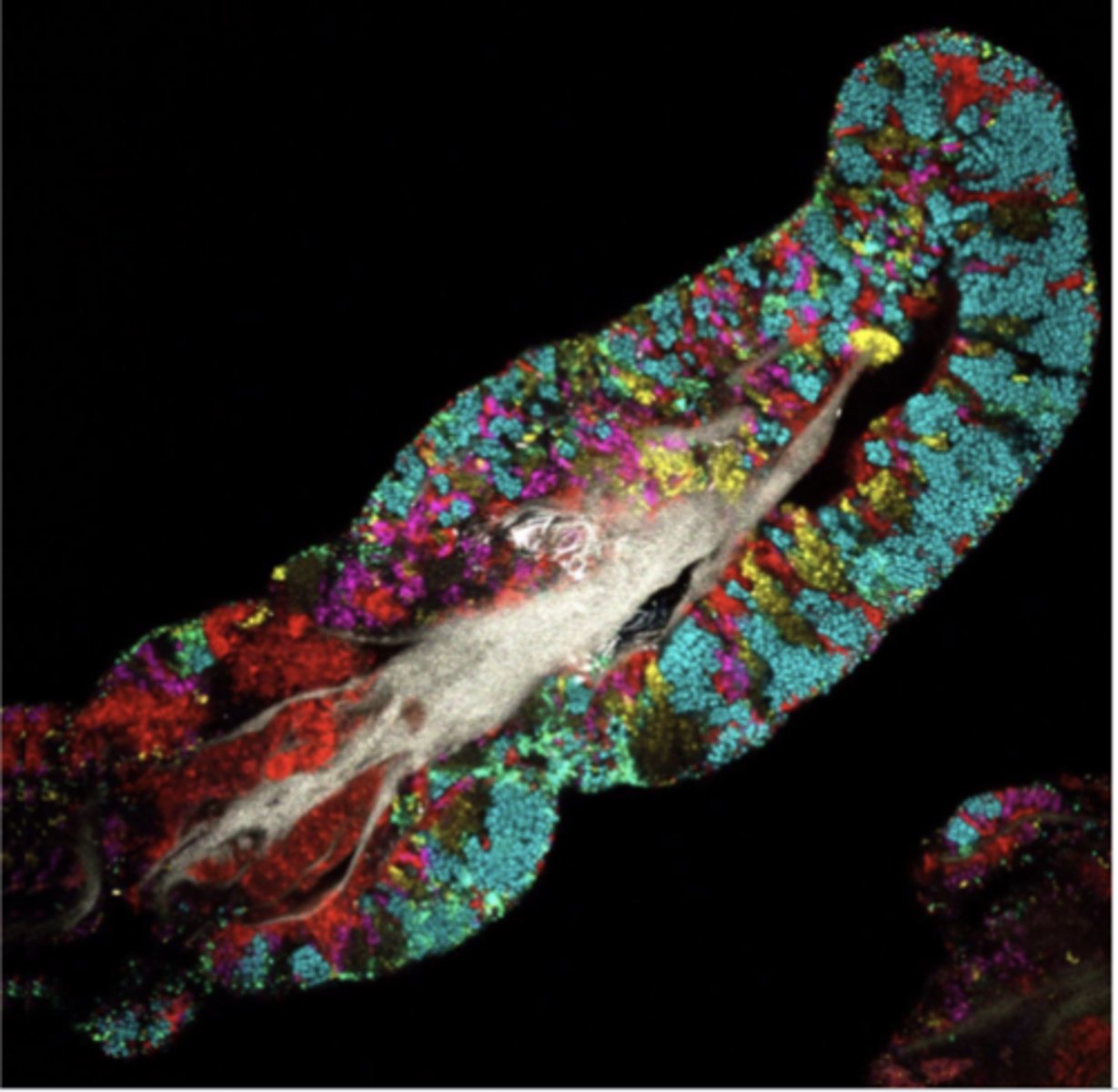
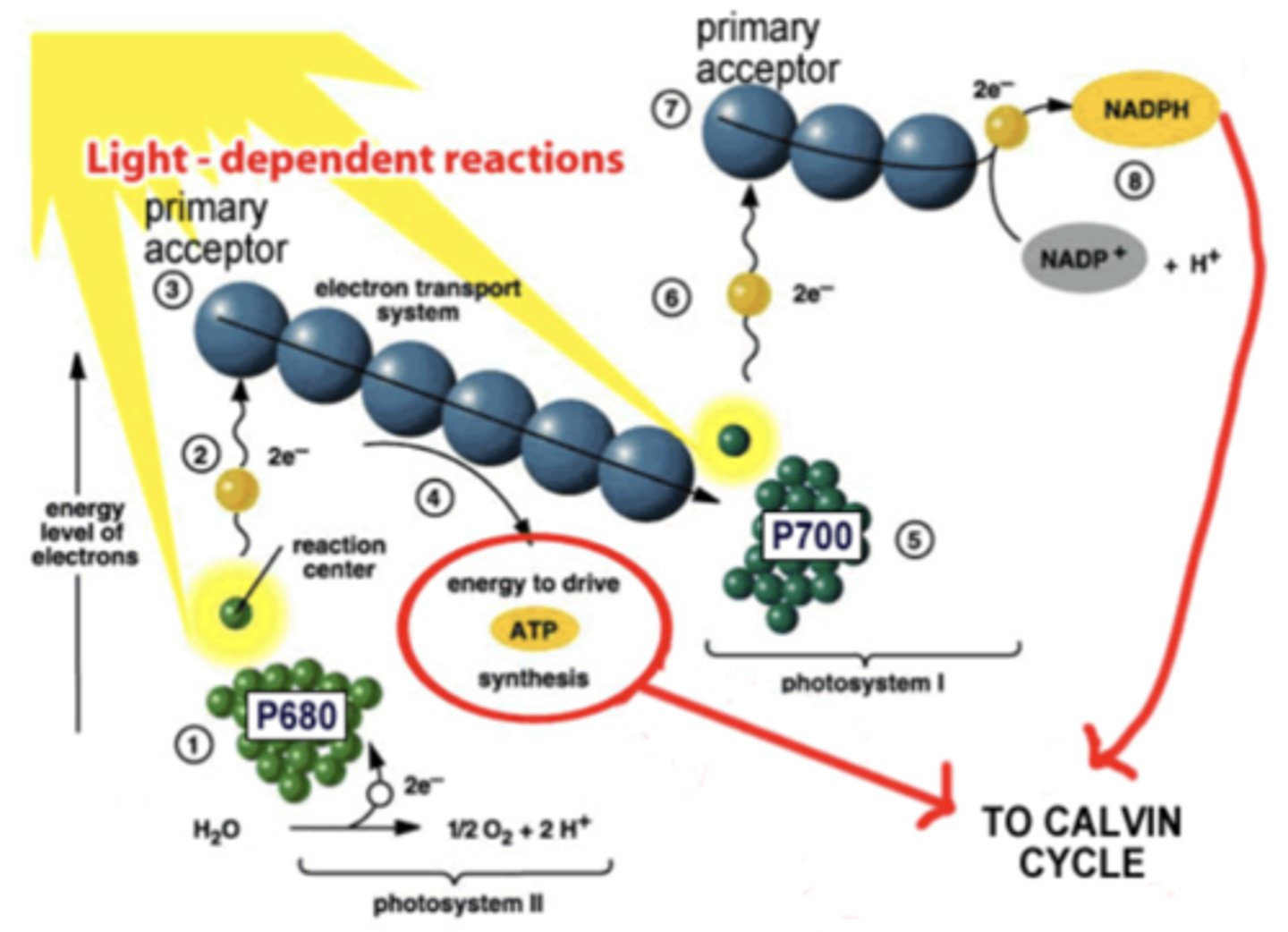
How does energy flow into an ecosystem? What is endosymbiotic theory? What is the equation for photosynthesis and what is the way in which it works?
Energy enters most ecosystems through primary producers like plants, algae, and some bacteria, which use sunlight or inorganic chemicals to capture energy through photosynthesis or chemosynthesis, converting it into chemical energy stored in organic molecules
-the diagram shows endosymbiotic theory, which explains how complex eukaryotic cells (cells w nuclei and organelles) evolved from simpler prokaryotic cells through symbiosis wherein an ancestral eukaryote engulfed an aerobic prokaryote that became the mitochondrion; later, some of these early eukaryotes engulfed photosynthetic prokaryotes which evolved into plastids (chloroplasts)
-photosynthetic equation: CO2 + H2O -> C6H12O6 + O2; the diagram shows the light-dependent rxns of photosynthesis, also known as the Z-scheme of e- transport, occurring in the thylakoid membranes of chloroplasts and capturing light energy to produce ATP and NADPH, which are then used in the Calvin Cycle to make sugars
~light absorbs at P680 in Photosystem II, exciting e-s in chlorophyll; water is split into O2, protons, and e-s, the last of which replace those lost by P680, releasing O2 as a byproduct
~excited e-s are passed to an ETC btw PSII and PSI, releasing energy and pumping protons into the lumen, creating a proton gradient; ATP synthase uses this gradient to make ATP
~in photosystem I, light excites e-s in chlorophyll at P700 and excited e-s are passed to another primary acceptor; e-s lost from PSI are replaced by those arriving from PSII, and other e-s finally reduce NADP+ to form NAPDH
How is energy lost from an ecosystem?
The vast majority of energy is lost as heat to the environment and said heat is produced by cellular respiration, a necessary function for life; only ab 10% of a level's absorbed energy is absorbed by the next
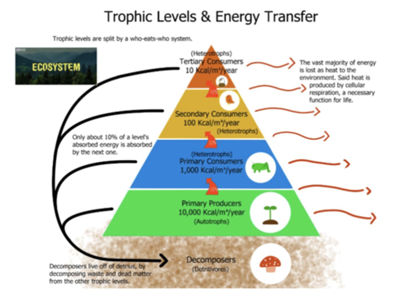
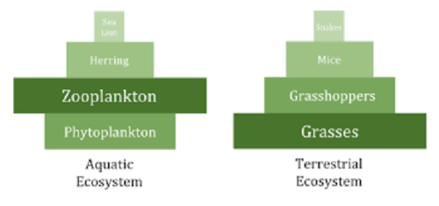
How does biomass generally change as you move up trophic levels? What is the main exception to this rule?
Biomass also decreases as you move up trophic levels
-in many aquatic ecosystems, the pyramid looks somewhat inverted bc phytoplankton reproduce and grow so quickly that they support a larger biomass of consumers, even if their standing biomass is low
Why are carnivores at the top of food chains among the most vulnerable to human activities?
Low in numbers and also very important in controlling prey and other predator populations; reintroducing or conservation of predators stabilizes ecosystems which then provide climate change mitigation
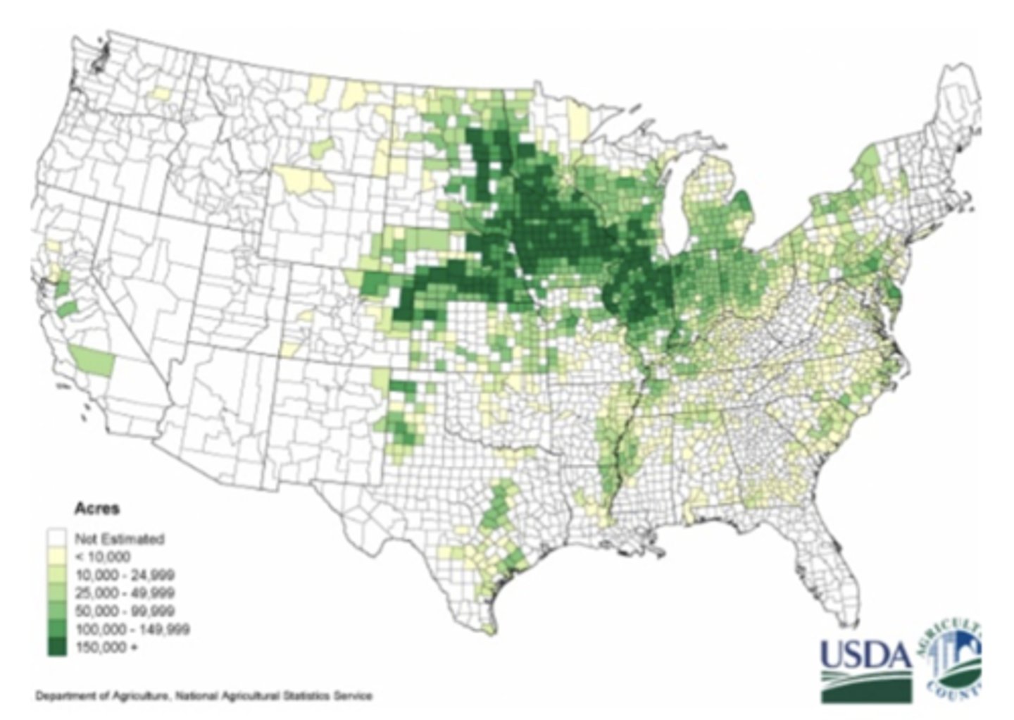
What is the Corn Belt of the US and why is that region of particular fertility?
Region of highest corn production where climate, soil, and infrastructure strongly support intensive agriculture; warm summers ideal for growth, moderate to high rainfall during growing season, prairie soils deep and nutrient-rich, and large expanses of flat land
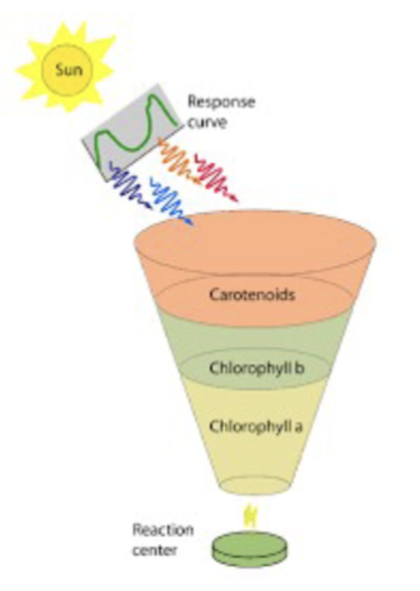
How do plants capture a broad spectrum of light from the sun?
Different pigments absorb different parts of this spectrum:
carotenoids (orange band) absorb blue/green light, chlorophyll b (green band) absorbs blue and red-orange, and chlorophyll a (yellow-green band) absorbs mostly blue and red; thus expand the "response curve" of usable light, all of which is funneled into the reaction center where it's converted into chem energy
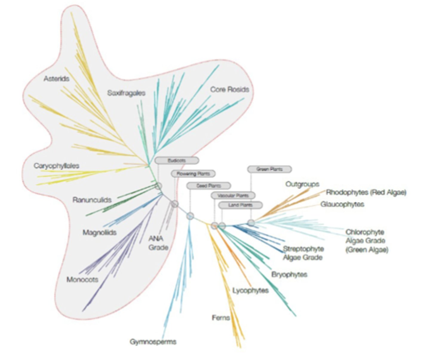
How did photosynthetic plants evolve and diversify?
In terms of plants, green algae first evolved chlorophyll-based photosynthesis; from there, plants split into bryophytes (first land plants), lycophytes (early vascular plants), ferns, and seed plants
-seed plants further split into flowering (monocots, eudicots, magnoliids, asterids, core rosids, and a variety of others) and non-flowering lineages; outgroups like Rhodophytes (red algae) and Glaucophytes use different pigments and are more distantly related
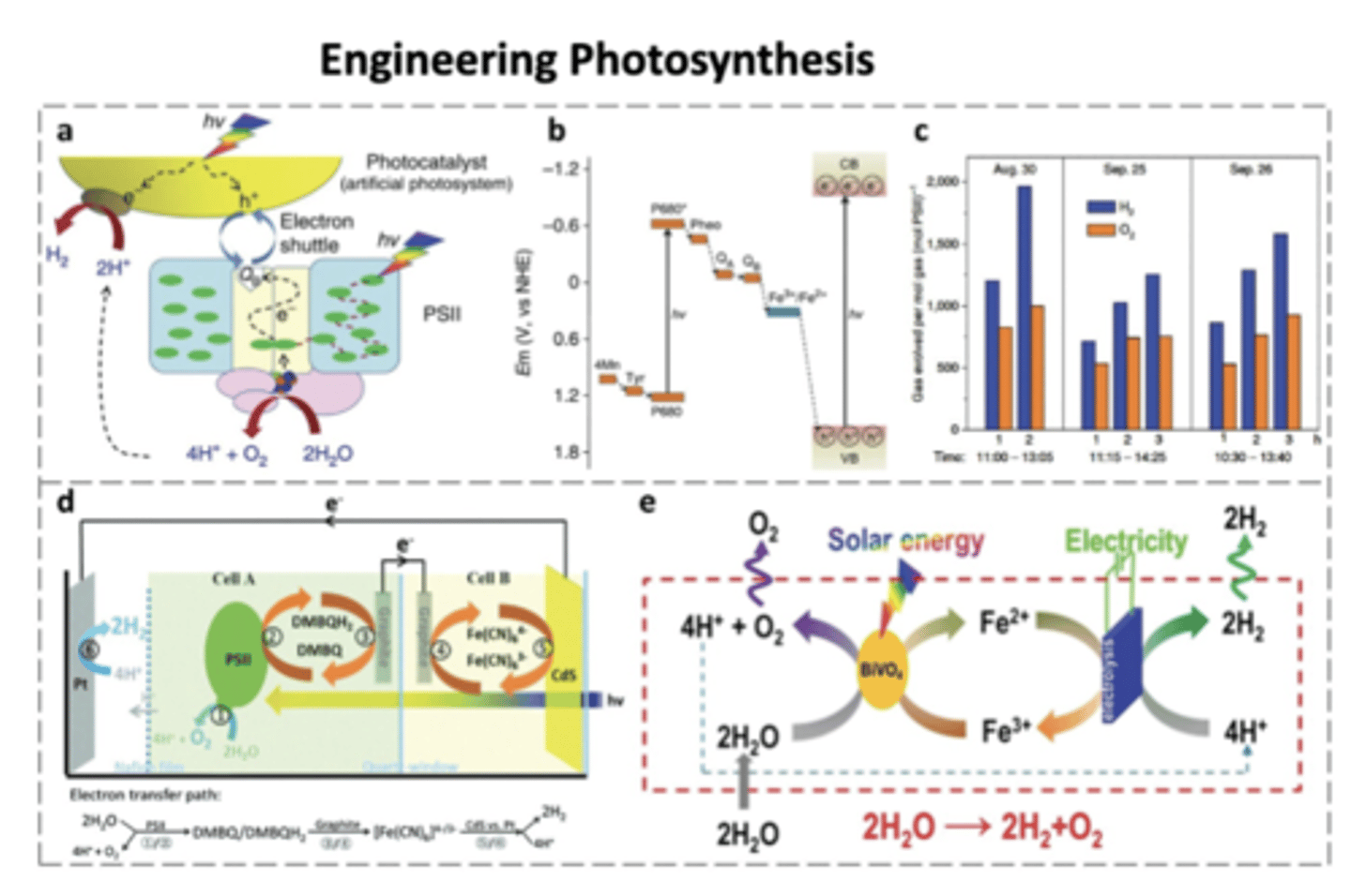
How does artificial/engineered photosynthesis as a clean fuel source work? What are some ways in which its efficiency is improved?
Hybrid photosynthetic devices couple the natural photosystem II (PSII), which splits water into protons, e-s, and O2, and an artificial photocatalyst (CdS) acting as a synthetic PSI to accept e-s and drive H2 production (net rxn: 2H2O + 4H+ + O2 + 4e-, e-s + H+ -> H2 gas); as shown in (c), both H2 and O2 are produced, roughly in 2:1 stoichiometric ratio expected for water splitting, confirming that the engineered sys works in practice
-electrons are transferred btw the two cells through a shuttle system, improving efficiency and preventing unwanted back-rxns; some systems integrate solar energy with electricity input to maximize hydrogen fuel generation
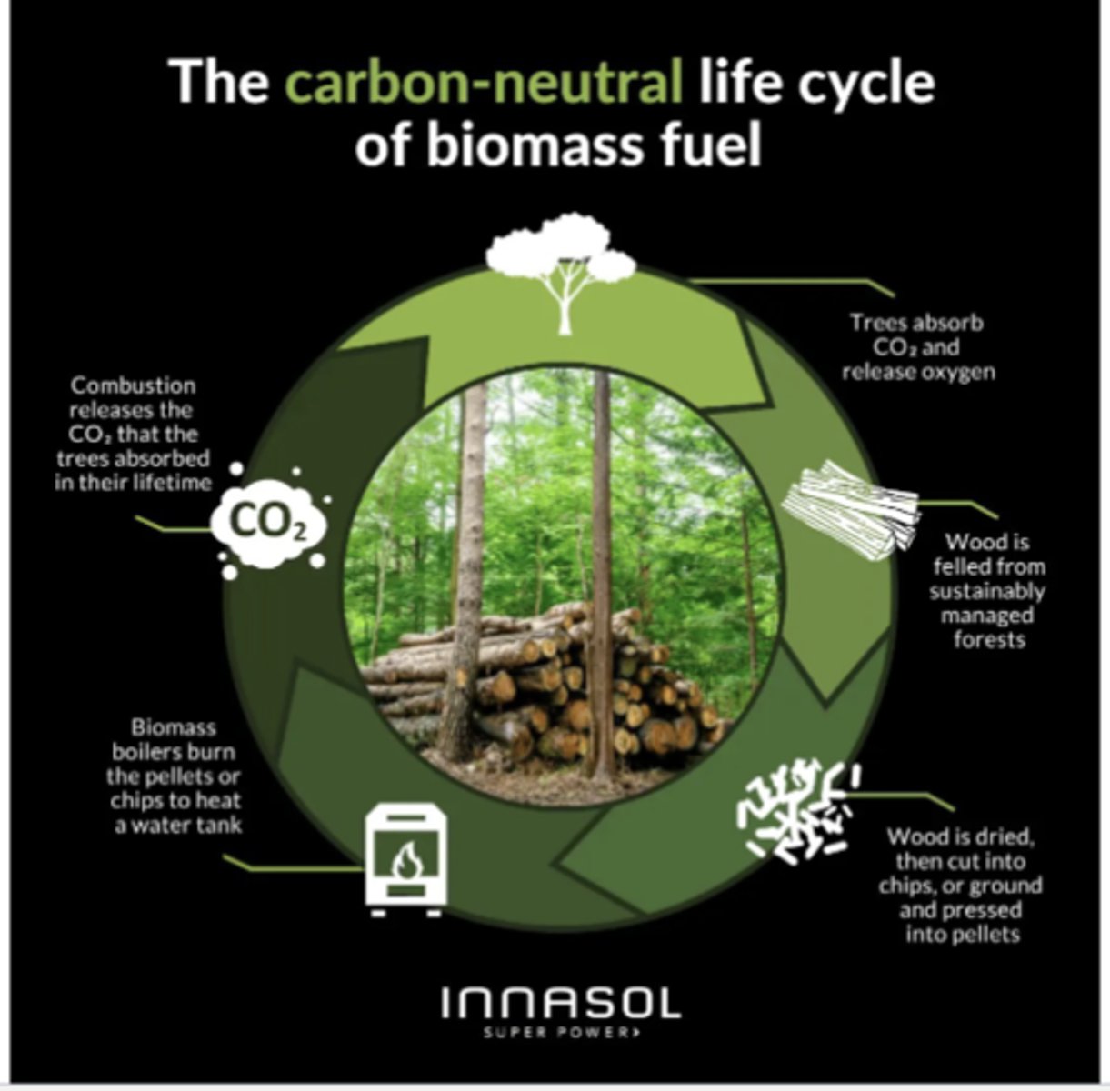
How can using wood and plant material for energy be considered sustainable if managed correctly?
Trees absorbs CO2, stored in their wood, leaves, and roots, and release oxygen; wood can then be felled from sustainably managed forests, harvesting trees in a way that ensures new ones are planted or naturally regrow
-wood is processed into fuel, compressed into pellets, a common biomass fuel; biomass boilers burn the pellets or chips to generate heat, releasing the CO2 trees had absorbed during their lifetime
-since the released CO₂ equals the CO₂ that the trees originally absorbed, the process can be considered carbon-neutral as long as new trees are grown to replace the harvested ones
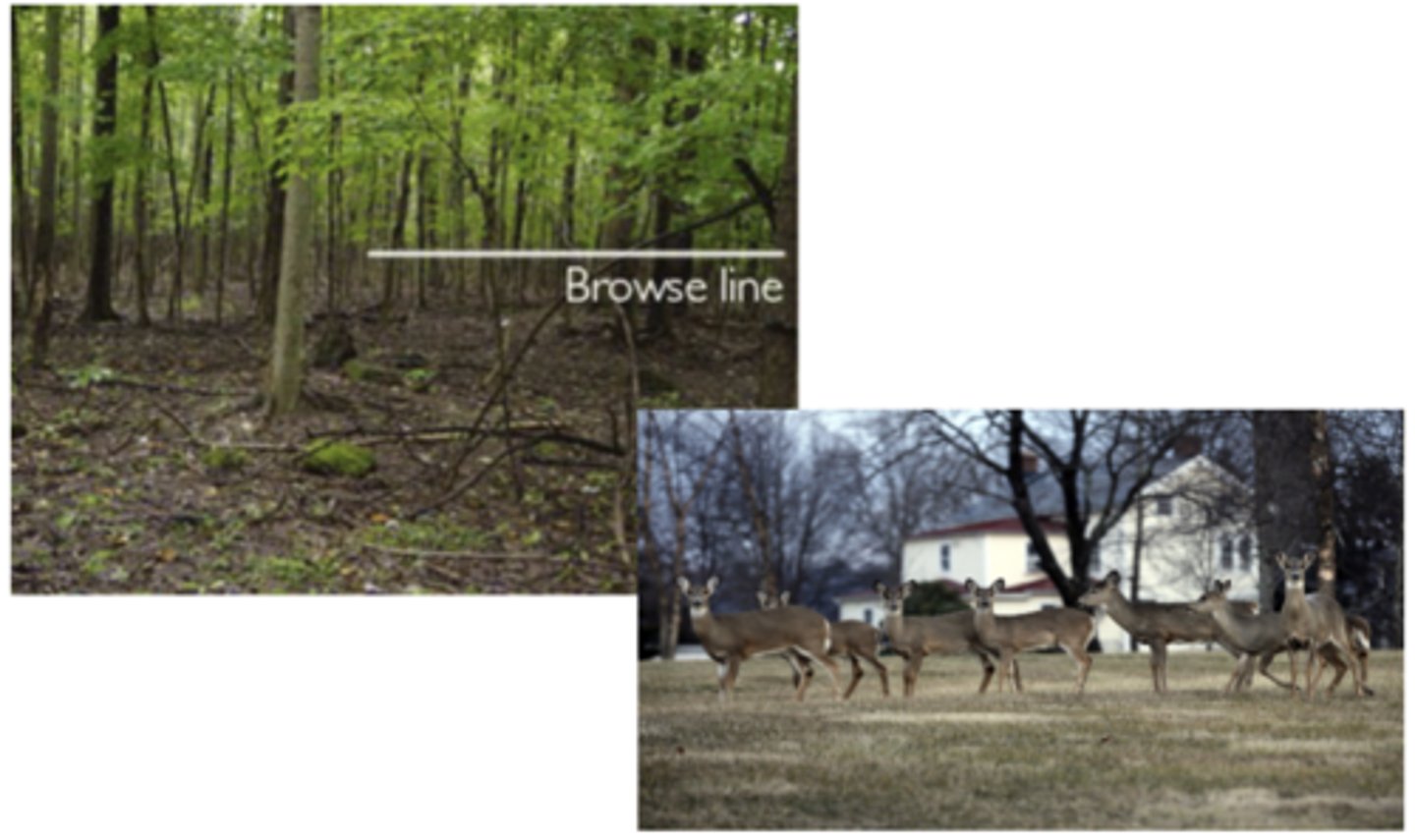
What is the browse line of a forest? How is it affected by deer overpopulation?
Clear horizontal line in the forest where vegetation has been eaten away up to the heigh that deer can reach; below this line, shrubs, young trees, and undergrowth are missing because deer have eaten them
-when deer are overpopulated (i.e. loss of carnivores in the ecosystem), they consume too much vegetation and reduce plant regeneration and biodiversity
What roles do microbiomes have in forests? What do Mycorrhizal fungi do?
Soil microbes decompose fallen leaves, dead wood, and animal remains, releasing nutrients (N, P, K, etc.) back into the soil, certain bacteria (e.g., in root nodules or free-living in soil) convert atmospheric nitrogen (N₂) into forms plants can use, some microbes protect roots and help trees cope with stress, store carbon in soil or consume methane, and link trees and plants
-Mycorrhizal fungi form symbiotic associations w tree roots, extending the root network + improving uptake of phosphorus, nitrogen, and water; also transfer carbon btw trees
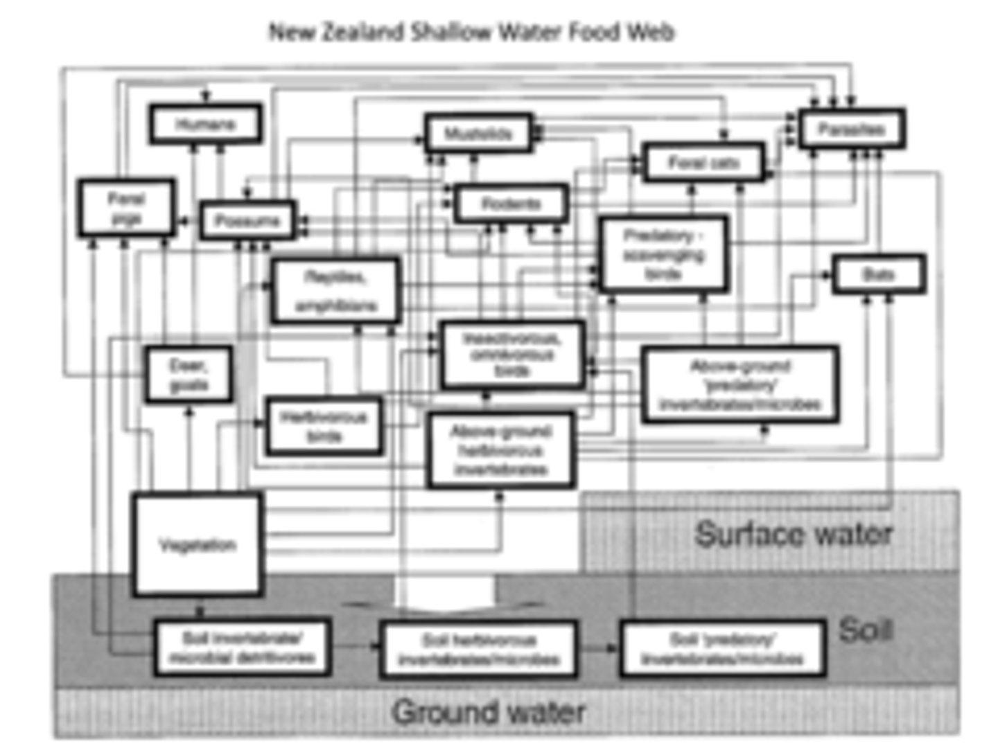
What is a Podocarp forest? In a study in a New Zealand Podocarp forest which attempted to mitigate introduced species (pigs, feral cats, lizard, rodents, bat) by applying toxins, what did they find about how the introduced species vs the toxins negatively impacted the environment
A podocarp forest is an ecosystem dominated by tall, evergreen coniferous trees of the Podocarpus genus, which often form the emergent canopy above a dense understory
-study showed that in this complicated food web, with an aerial spray to invasive species, the harm which the invasive species did to the ecosystem was more severe than that of the toxins moving through it; resistance such as this, however, depends on the ecosystem
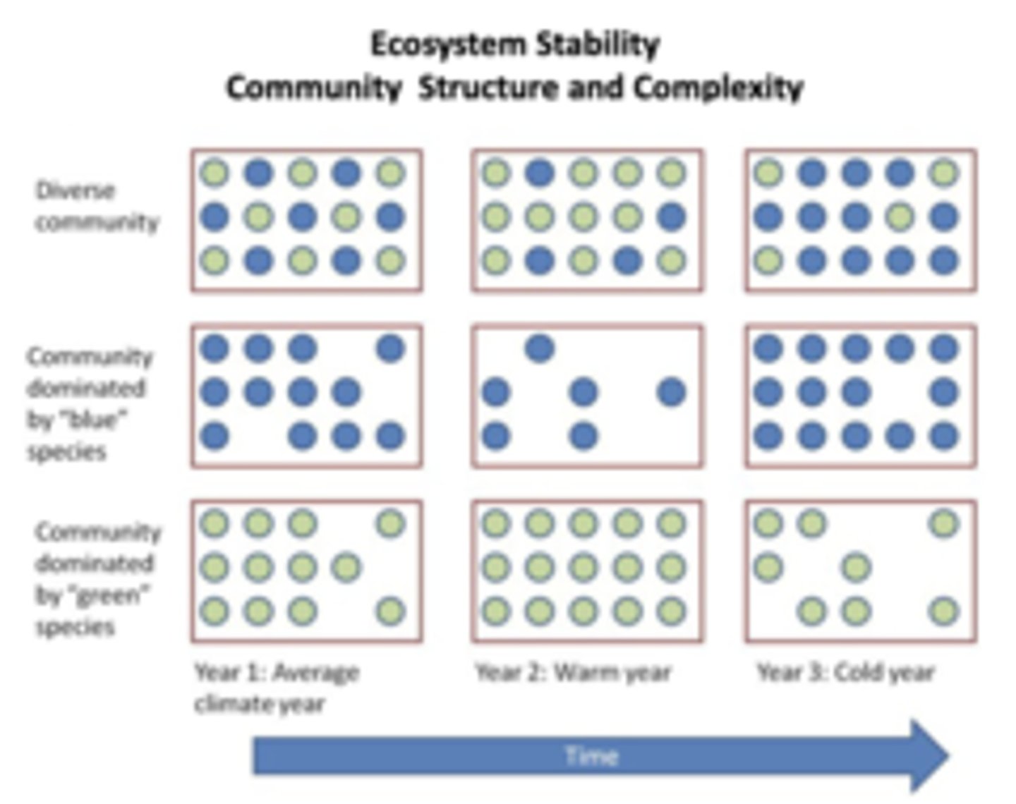
What is species richness, species abundance, and species diversity? How do they reflect an ecosystem's ability to recover following perturbations? What are keystone taxa?
Species richness = number of species, species abundance = number of individuals of a species, and species diversity = function of both richness and abundance; complex communities have greater stability/ability to recover following perturbations (due to more ways of adapting to an environment)
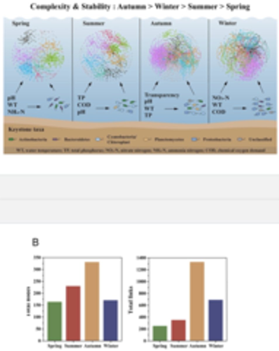
-for example, ecological stability of microbial communities in Lake Donghu is regulated by keystone taxa, which organisms or types of organisms w a disproportionately large impact on their ecosystem or community relative to their abundance, playing a vital role in maintaining its stability and structure
How does the microbiome of Lake Donghu vary based on the seasons?
Environment (chemical, temperature, etc.) changes depending on the seasons, meaning different species thrive at different parts of the year
-most diversity occurs in autumn
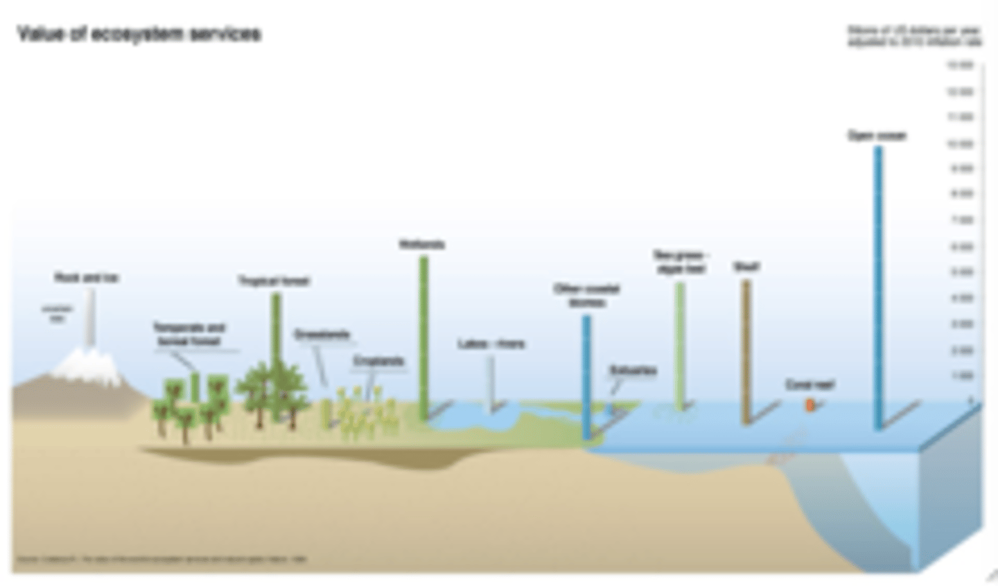
Ecosystems have numerous crucial roles for humans. What are some of these roles?
-provide food, water (some ecosystems purify and conserve water), timber, oil, natural gas, etc.
-regulation of clean air, decomposition, pollination, erosional control, water flow, disease vectors, etc.
-supporting energy flow, nutrient cycling, water cycle
-cultural/non-material aspects like art, recreation, and philosophy (environmental ethics, for ex the idea of the early US that the natural resources of the land were put there by god for the country)
Value of Ecosystem Services in Billions of US $'s A Year
Picture
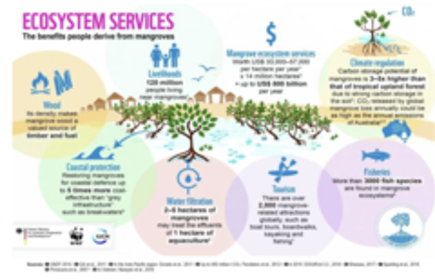
What numerous ecological benefits do wetlands and mangroves provide?
Wetlands clean water, very high biodiversity, reduce flood damage in storms and hurricanes, breeding grounds for many fish populations (those which stay local and go to sea), important in nutrient cycling and primary production
-similarly, mangroves provide wood, coastal protection, water filtration, tourism, fisheries, and climate regulation
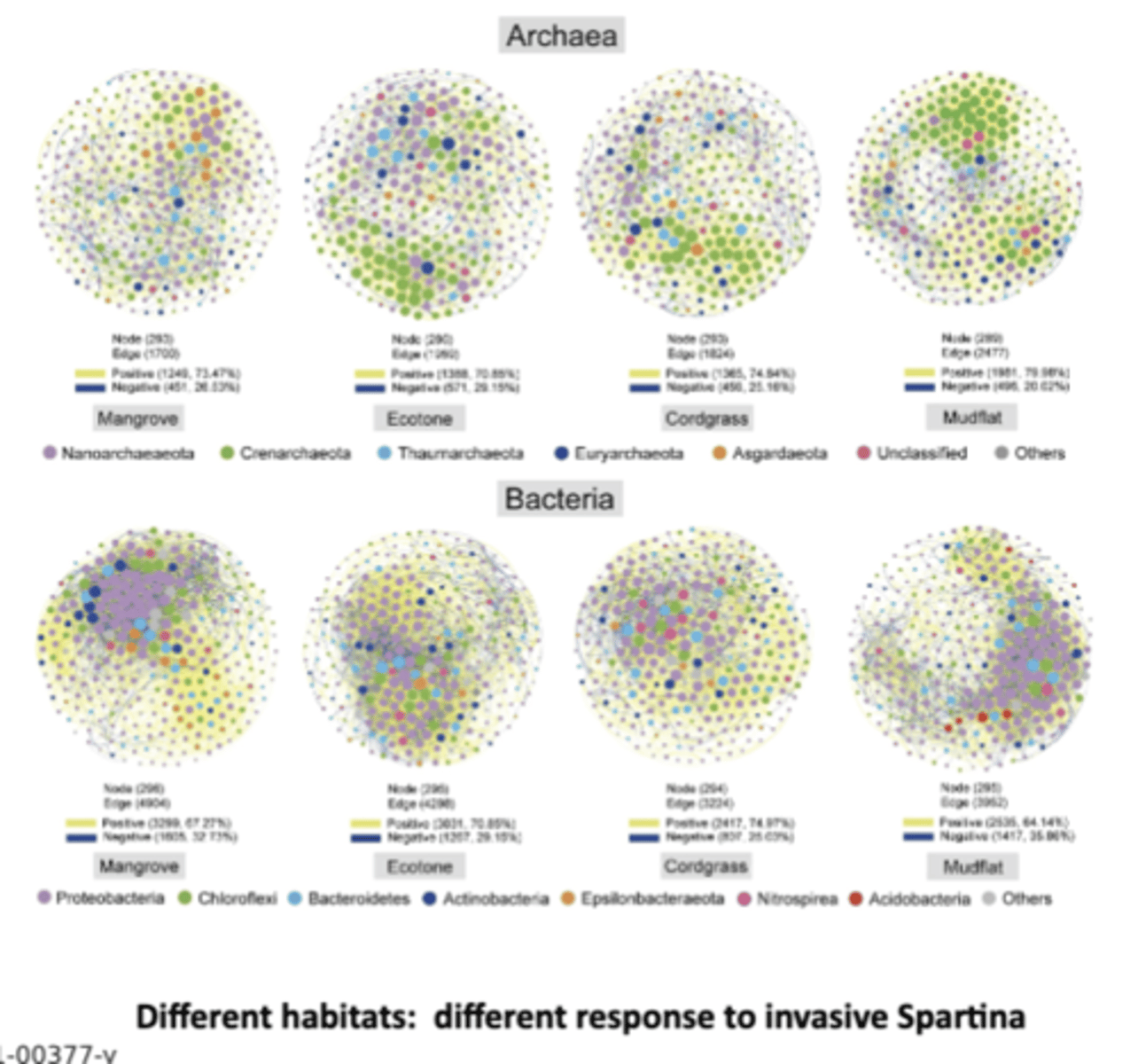
In a mangrove ecosystem in Asia, Spartina alterniflora (a grass) was introduced from the US and Europe as a blue carbon sink. What is blue carbon and what effect did this introduction have?
Blue carbon is organic carbon captured and stored by marine and coastal ecosystems like mangroves, salt marshes, and seagrass beds
-despite this, found spartina degraded the ecosystem and microbiome; however, diff habitats have been found to have diff rxn to such introduction
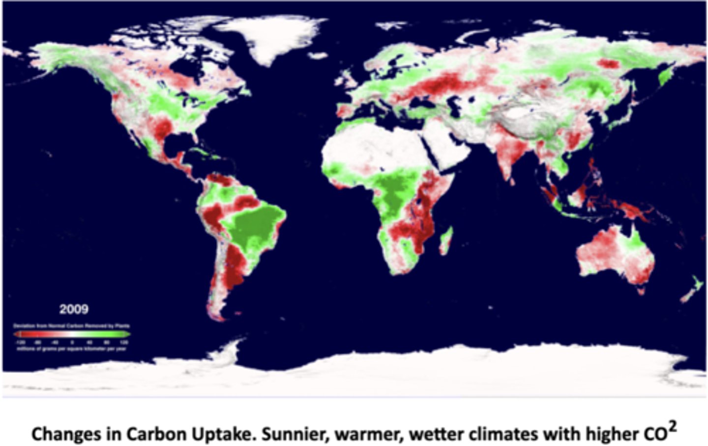
How does plant carbon uptake vary with climate and environmental conditions?
The pictured data shows changes in C uptake by plants compared to normal levels; green areas had higher-than-normal carbon uptake (plants absorbed more CO₂), red areas had lower-than-normal carbon uptake (plants absorbed less CO₂), and white/gray areas had near normal or little data
-sunnier, warmer, wetter climates with higher CO₂ → more photosynthesis → higher carbon uptake (green zones, e.g., parts of South America, central Africa, and Southeast Asia).; stressful conditions (heat, drought, deforestation, fires, land-use change) → lower carbon uptake (red zones, e.g., the Amazon during drought, sub-Saharan Africa, Indonesia, Australia); high-latitude regions (Canada, Siberia, Northern Europe) → green patches show enhanced plant growth due to longer growing seasons and warming temperatures
~droughts, deforestation, and fires reduce plant uptake, making ecosystems a carbon source instead of a sink
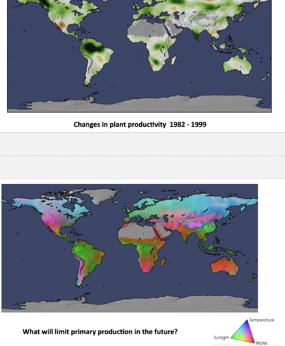
How did plant productivity change worldwide from 1982-1999, and how does this relate to the 2009 plant carbon uptake data from the last slide? What are the projected biggest limits on future plant growth?
The top map shows how plant productivity changed 1982-1999, with green regions representing increased productivity and brown/gray regions representing decreased productivity; lesser productivity generally correlates with lesser carbon uptake in 2009
-it's predicted that the biggest limit to plant growth will vary by region in the future, but the 3 main ones are water scarcity in arid/semi-arid zones, temperature in polar/high-latitude areas, and sunlight in dense forests; water stress is expected to be the main barrier to primary production globally
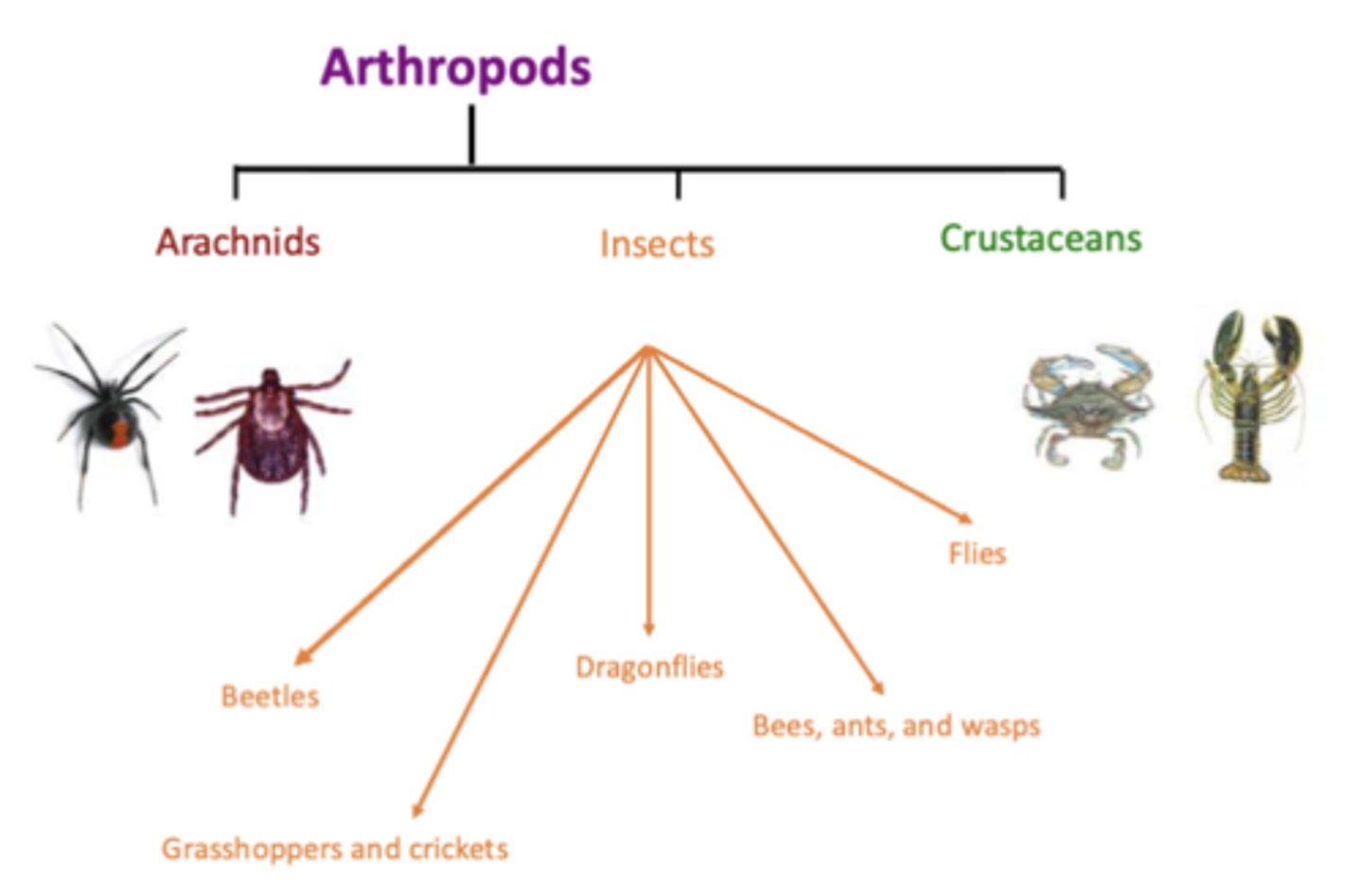
What are ticks? What are arachnids? Are ticks present on all continents and do all ticks feed on humans?
Ticks are arachnids and external parasites which live by feeding on the blood of mammals, birds, and some reptiles and amphibians; arachnids are a class of arthropods that includes spiders, scorpions, mites, and ticks, characterized by their two-part body (cephalothorax and abdomen), at least four pairs of legs, and the absence of antennae or wings
-there are 900 species of tick and there are some on all continents, though majority of ticks don't feed on humans
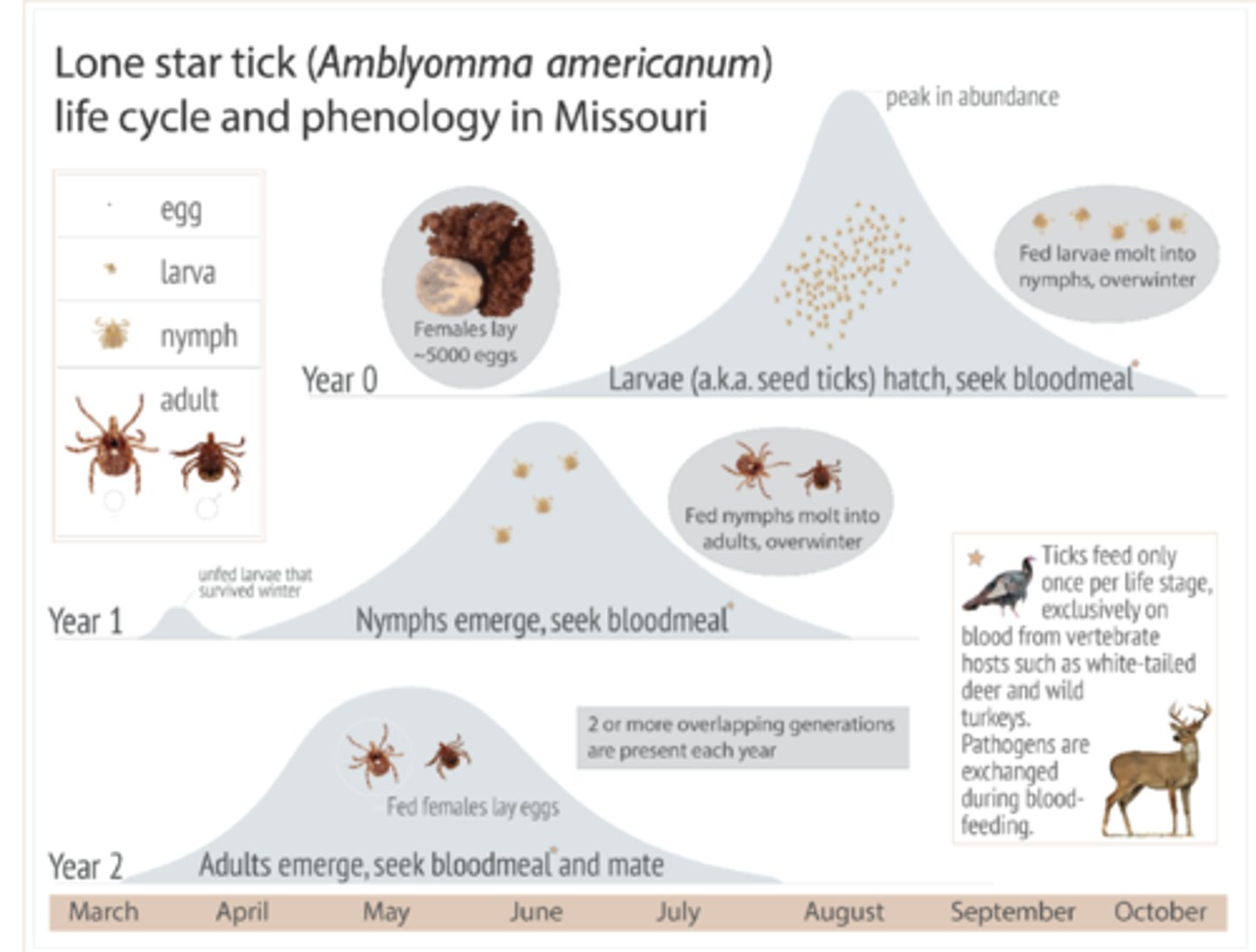
What are the 3 common Missouri ticks which bite people? How do ticks find their food? How and why do ticks spread bacteria and viruses (pathogens)?
Lone Star, Dog, and Blacklegged (deer) ticks
-ticks are found in a variety of natural environments, especially in wooded areas, grassy fields, and brushy habitats, often near the margins of forests
-find hosts by using senses called Haller's organs to detect body heat, moisture, carbon dioxide (CO2), and vibrations from animals; ticks then climb onto potential hosts, often by waiting on the tips of plants and using a behavior called "questing" to latch on
-ticks spread bacteria and viruses by feeding on infected animals and then transferring the pathogens to a new host through their saliva during a subsequent bite; pathogens, like the bacteria that cause Lyme disease, can be ingested by the tick during a blood meal from a sick animal and then passed into the new host when the tick bites and injects its saliva
~ticks are obligate parasites, meaning they must feed on the blood of a host to survive and reproduce, and in some cases, the relationship between the tick and the bacteria can be symbiotic
What times of year are lone star ticks most active in Missouri?
Ticks feed only once per life stage, so at diff times of year different tick stages are active; for ex, the lone star tick larvae are most active around August, nymphs are most active in June, and adults are active April-July
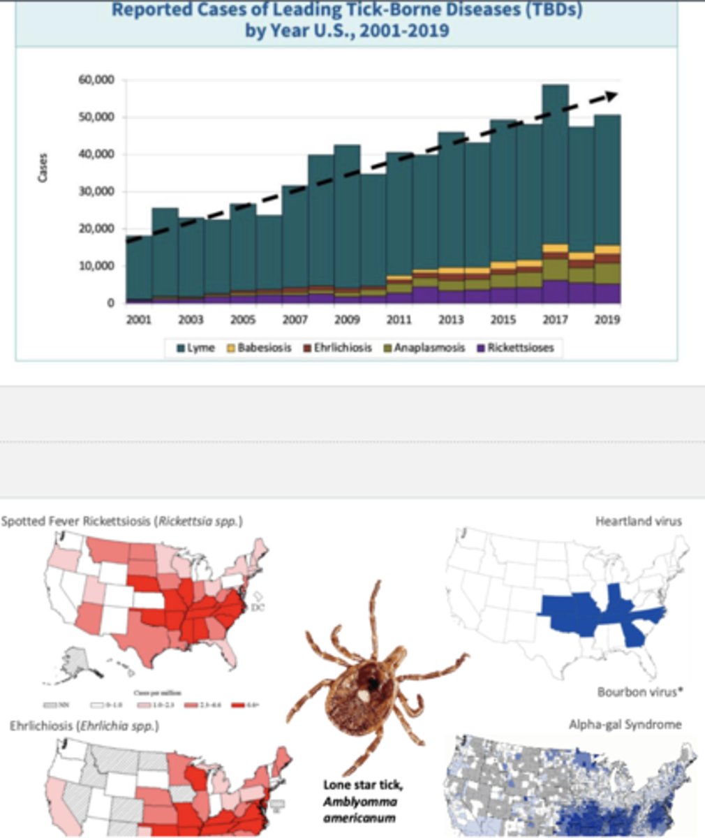
How have tick-borne diseases in the US trended in the past 20 years? Why?
The bar graph shows a clear increasing trend in reported tick-borne disease cases over time, especially Lyme disease; many ticks (i.e. lone star tick) have expanded due to warmer winters and longer growing seasons due to climate change, extending active seasons for ticks and improving reproduction
-additionally, suburban development near forests increases chance of tick bites
-emergence of new tick-borne pathogens like Heartland virus and Bourbon virus, present in Missouri and Kansas, has also increased rates
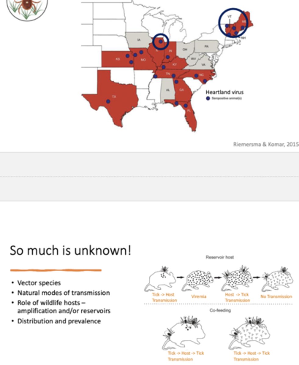
Where in the US has the Heartland virus been detected? What remains unknown about it? What are the reservoir host and co-feeding pathways?
Top map shows sates in red where Heartland virus has been detected and blue dots indicate places where animals tested seropositive (antibodies present), meaning they were exposed to the virus
-vector species, natural modes of transmission, which animals serve as reservoirs (carry virus long-term) or amplification hosts (increase viral levels and transmission risk), and prevalence remain unknown; reservoir host pathway is when tick bites a host, transmitting the virus for when another tick bites, and co-feeding pathway is when multiple ticks feed close together on same host, so the virus passes directly from one to another through localized skin infection
How do scientists attract ticks to study them?
By using methods that exploit the ticks' natural behaviors, including their reliance on carbon dioxide and pheromones to find hosts; the most common techniques are dragging or flagging for broad sampling, and setting up traps baited with chemical attractants (i.e. pheromones, CO2) for more targeted collection
What is the history of coyotes in San Francisco? What ecological purpose do coyotes serve in cities?
In the early 1900s, a government-sponsored campaign encouraged residents to kill coyotes they saw, thus eradicating their populations, but the animals later returned and today number roughly two per square mile; thus, actions like maintaining clean water sources, monitoring our pets, planting native flora, and avoiding toxins like insecticides and herbicides are critical instead
-coyotes serve an important ecological purpose, controlling the feral cat and rat populations, the latter of which carry many diseases
What mutualism exists between African forest elephants and the ebony tree? How have African elephant populations declined in the past 3 decades? How do elephants maintain forest habitats?
Elephants rely on the ebony trees as a preferred food source for their fruit while elephant dung protects ebony seeds from seed predators, such that a decrease in elephant population corresponds to a significant reduction in ebony tree population and regeneration, efficiency and distance of ebony seed dispersal, and protection of ebony seeds from seed predators by elephant dung; this is of particular concern because African forest elephants are widely poached for ivory and have seen an 86% population drop in the past three decades, bringing them near extinction today
-ebony trees are not the only flora which rely on elephants as seed dispersers, as elephants maintain forest habitats by spreading the seeds of many species, recycling and distributing nutrients, and clearing the understory