Lecture 14 - Climate and other Niche Axes
1/50
There's no tags or description
Looks like no tags are added yet.
Name | Mastery | Learn | Test | Matching | Spaced | Call with Kai |
|---|
No analytics yet
Send a link to your students to track their progress
51 Terms
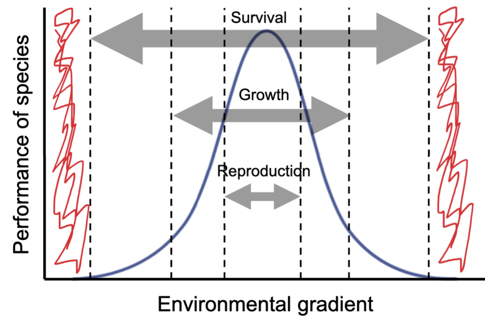
How do environmental gradients affect species?
Along different environmental gradients, species have different ranges of tolerance.
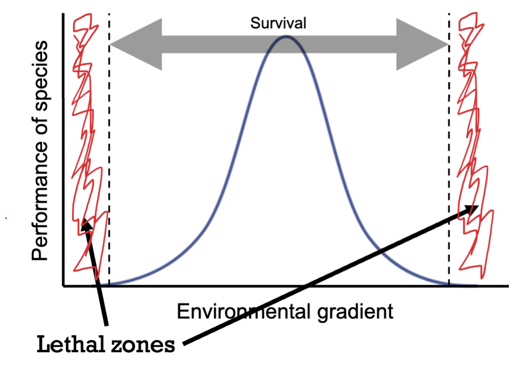
How do species’ survival, growth and reproduction ranges differ along environmental gradients?
survival has the greatest range across environmental gradients
growth has the second largest range across environmental gradients
reproduction has the smallest range across environmental gradients
*this is a generalisation!
Define the ecological niche.
A quick way to describe all the environmental factors that a species needs and can tolerate in order to survive.
Who came up with the term ‘ecological niche?’
G. Evelyn Hutchinson
What is a very important variable that oftentimes determines where a species lives?
Climate
What is temperature a function of?
Latitude. This is because temperatures are warmer by the equator (lower latitudes) but colder by the poles (higher latitudes).
At higher latitudes what are seasons a function of?
Temperature. This is because when at low temperatures we have the winter and at hight temperatures we have the summer.
At lower latitudes what are seasons a function of?
Rainfall. This is because at lower latitudes there are rainy and dry seasons (rather than winters and summers).
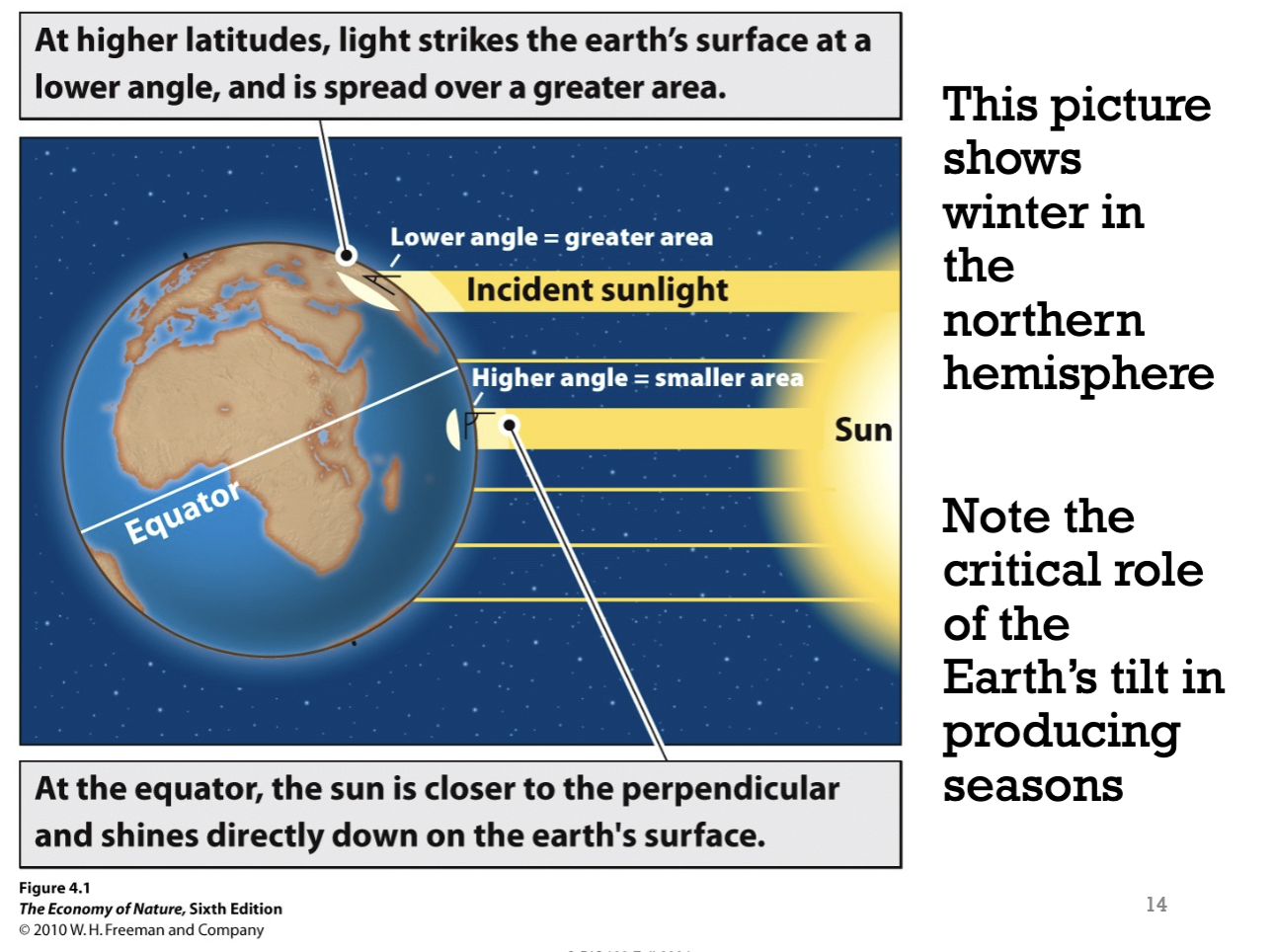
How does latitude determine temperature?
Depending on the latitude of the earth, the sun shines on the earth’s surface at different angles. Therefore, making the photon density higher in some regions (making it hotter) and lower in other regions (making it cooler).
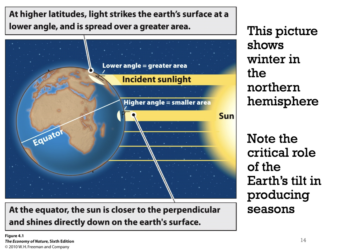
Why is the temperature hotter in regions near the equator?
The sun shines most directly on the earth’s surface at the equator (at a 90º angle). This concentrates the sun’s energy over a small area. Hence, the photon density is very high at the equator.
Why is the temperature cooler in regions at higher latitudes?
Due to the spherical shape of the earth, at higher latitudes, the angle at which the sun shines onto the earth’s surface is lower. Hence, the sun’s energy spreads over a larger area. Photon density is therefore lower, and the surface of the earth heats up less (hence, winter occurs there and not at the equator).
How does winter in the northern hemisphere form?
Due to the rotation of the earth during that time, the angle that the sun shines onto the surface of the earth at that region is lower. Hence, photon density is lower than before and temperatures are cooler than before. Hence, winter starts.
Why is the southern hemisphere summer when the northern hemisphere is winter?
Due to the rotation of the earth during that time, the angle that the sun shines onto the surface of the earth at Southern Hemisphere becomes higher. As a result, the photon density becomes higher and temperatures get warmer there. Hence, summer starts in the southern hemisphere but NOT in the northern hemisphere.
Which region of the world has the most solar energy?
Regions by the equator. This is because the sun shines down most directly on the earth’s surface.
How are the patterns of rainfall around the globe determined?
Atmospheric
circulationOffshore ocean currents
Rain shadows
How does atmospheric circulation of the Hadley Cell affect rainfall?
Hadley cells make equatorial regions rainy
This is because:
regions by the equator are the hottest and thus have lots of hot air
since hot air rises, large air masses form
because the hot air masses cool as they move away from the earth’s surface, the water vapour in them condenses and falls as rain
that’s why it’s so rainy near the equator and why regions located there have seasons called ‘monsoon season’ or tropical rainforests
How does atmospheric circulation work?
regions by the equator are the hottest and thus have lots of hot air
hot air rises and air masses form as a result
as hot air rises, it cools at a certain rate (5-10ºC/km)
then some rain stuff (talked about in another flashcard) happens
the air masses hit the edge of the upper atmosphere and drifts 30º north and 30º south (away from the equator)
then they fall down to the earth as dry air masses
How do deserts form?
The dry air masses that have let out their rain in other regions, descend at 30º north and 30º south. This forms deserts.
Define Hadley Cells.
They are atmospheric patterns that move air around the globe, transporting energy to different regions of the globe.
How does the churning of the hadley cell affect other atmospheric cells?
The churning of the hadley cell sets up a ferrel cell that churns in the opposite direction, at 30-60º north and 30-60º south.
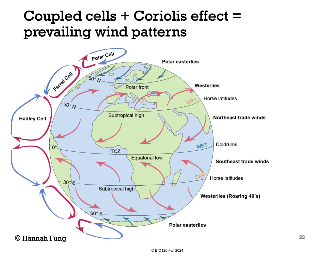
How does the churning of the ferrel cell affect other atmospheric cells?
The churning of the ferrel cell sets up a polar cell that churns in the opposite direction of the ferrel cell but in turn, the same direction as the hadley cell, at 60º north and 60º south.
How do the interactions between the different atmospheric cells affect the climates of different regions?
Some regions become dry or wet.
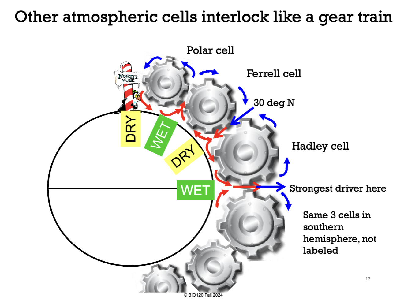
What zone creates the Hadley Cell?
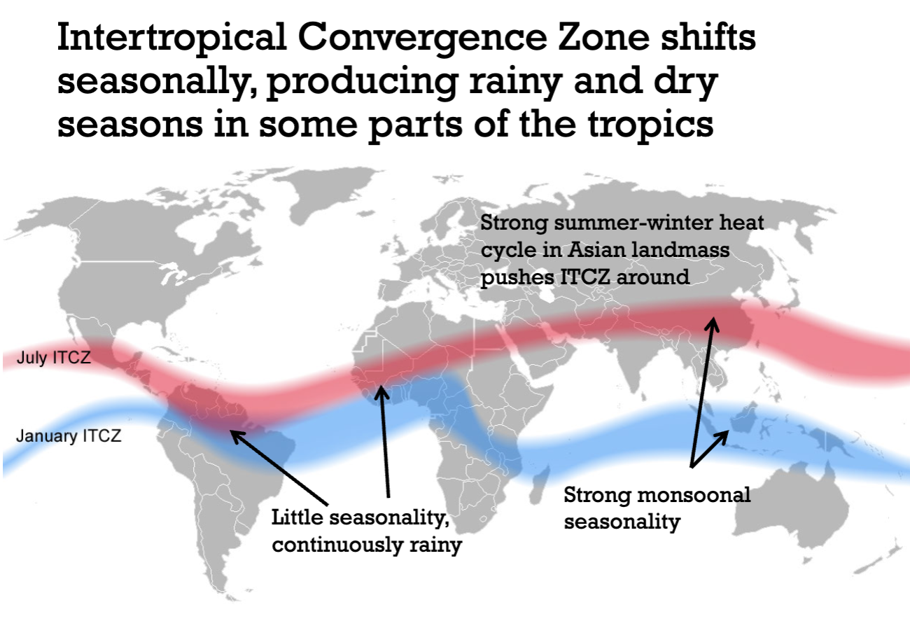
The Intertropical Convergence Zone (often drawn as a line of rainclouds along the pacific ocean).
Does the Intertropical Convergence Zone stay right above the equator year round?
No.
Why doesn’t the Intertropical Convergence Zone stay right above the equator year round?
Because the earth is tilted off its axis.
Does the hottest part of the earth’s surface change year round? And why?
Yes. Because the Intertropical Convergence Zone changes.
What is the Intertropical Convergence Zone?
A low-pressure region that circles the Earth near the equator where the trade winds of the Northern and Southern Hemispheres meet.
Often characterised by a band of clouds, heavy rain, and light/variable winds.
Why do the northern parts of the americas have weaker dry and rainy seasons?
Because the intertropical convergence zone doesn’t move as much in those regions (it mainly moves in asia).
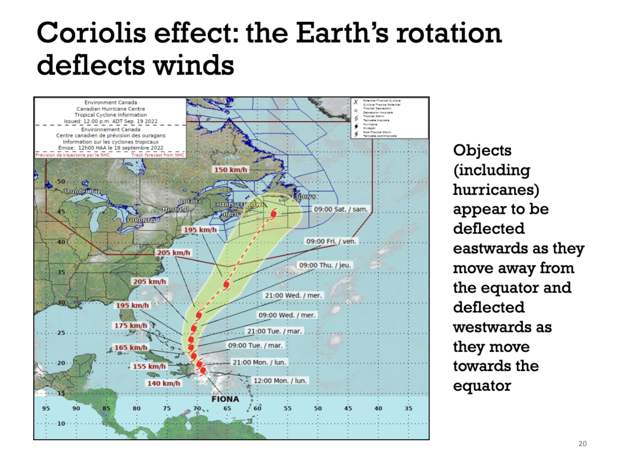
Explain the Coriolis Effect.
Firstly, objects or air masses at the poles move much slower than objects or air masses in other regions because the distance they have to travel to make 1 full loop around the axis of the earth is shorter.
Hence, in more southern regions, hurricanes, objects and air masses move much faster than the ground.
Due to this, hurricanes, objects and air masses that approach the northern hemisphere appear to be deflected eastward. This is because they move slower than the ground on the earth (bc objects and air masses at the poles move slower than other regions).
On the other hand, hurricanes, objects and air masses that go towards the equator appear to be deflected westward.
This appearance of being deflected eastward and westward is the Coriolis Effect.
Define Easterly Winds.
Winds that come from the east and blow towards the west.
How do we get Northeast and Southeast Trade winds?
Because Hadley Cells returning air masses towards the equator and the Coriolis Effect is deflecting them westward, Northeast and Southeast Trade winds are formed near the equator.
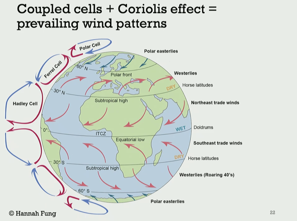
Define Westerly Winds.
Winds that come from the west and go towards the east.
How do we get Westerly Winds?
Ferrel cells blow winds away from the equator and the coriolis effect deflects the winds eastward. Resulting in Westerly Winds forming.

How do we get Polar Easterly Winds?
Because Polar cells generally move air near the earth’s surface back to the equator, the Coriolis effects deflects the winds westward. Hence, Polar Easterly Winds form.
What is wind near the equator called?
Doldrums
Why is there a little amount of wind near the equator?
At the equator most winds move towards the upper atmosphere (via Hadley Cells - see image) since hot air rises. Hence there’s not a lot of wind there.

Define Horse Latitudes.
A region where winds travel from the upper atmosphere to the earth’s surface, resulting in less wind there.
How does land mass play a role in wind strength?
Land mass can act as a wind break. Hence, the smaller the land mass, the greater the strength of the winds.
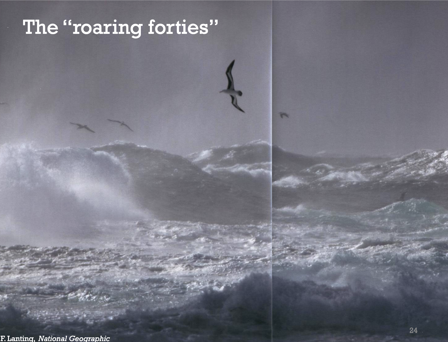
Define the Roaring Forties.
The rapid winds located 40º South on the Earth.
In general, what climate do plants grow best in?
Places that are warmer and wetter.
Define Primary Productivity.
The amount of plant growth in an area.
What do combinations of moisture and temperature result in?
They result in predictable types of vegetation, like Biomes (deserts, rain forests, tundra etc…).
What are secondarily important factors when creating a biome?
seasons
temperature
rainfall
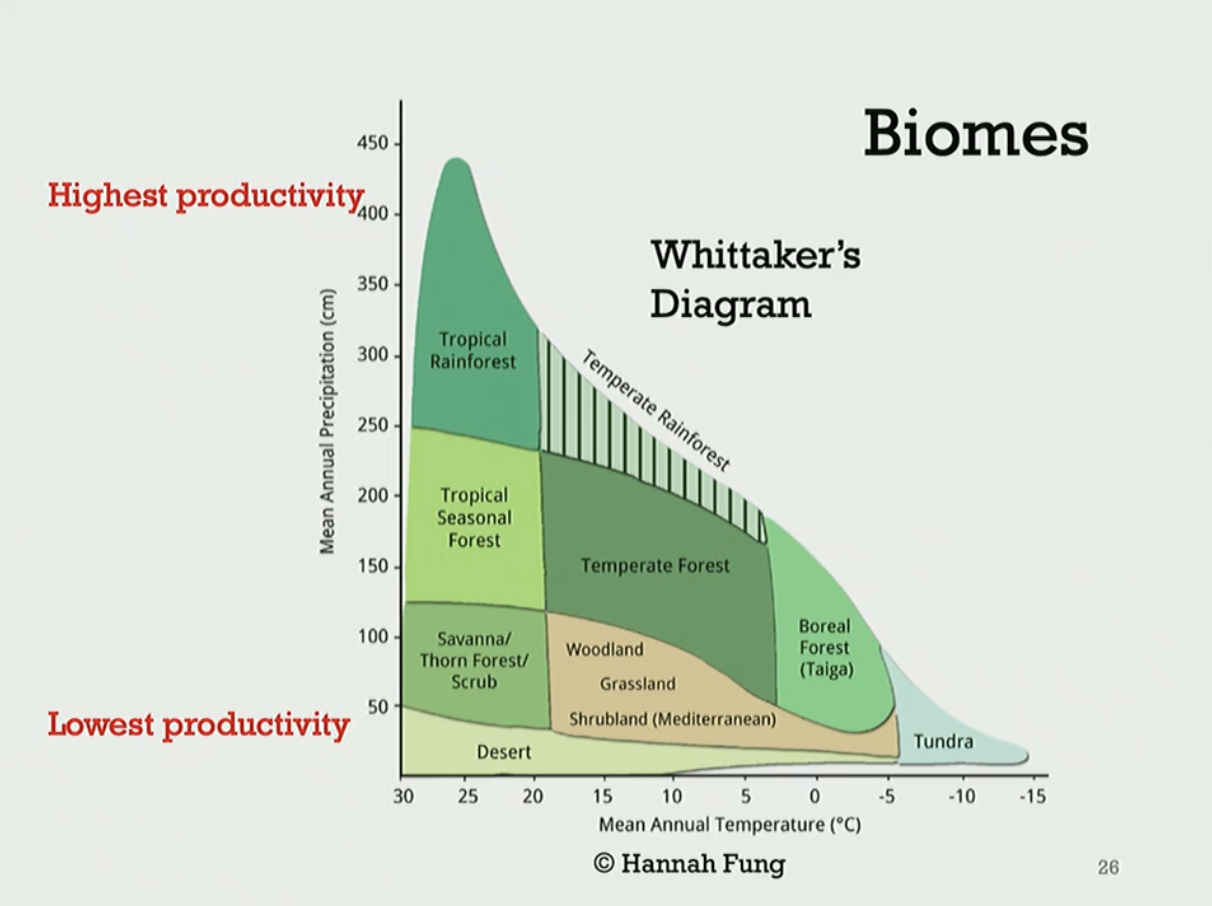
What is the relationship between precipitation, temperature and the biome that is formed?
Refer to the image.
What does latitude mostly determine?
Terrestrial Biomes.
What is the temperature in coastal climates typically like?
More steady/moderate temperatures. This is because oceans provide thermal inertia.
What is the temperature in continental climates typically like?
More extreme temperatures.
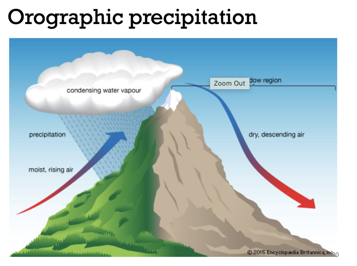
Define Orographic Precipitation.
Air forced up mountainsides and condensing as rain (so we get high rain on windward slopes of mountains and low rain on leeward - shielded with no wind - slopes of mountains).
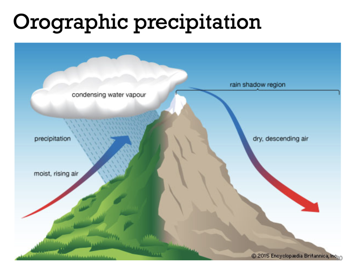
Define Rain Shadows.
A region having little rainfall because it is sheltered from winds with rain.
Where do temperatures vary more? The Northern Hemisphere or Southern Hemisphere?
Northern Hemisphere because there’s more land there.
Define Thermal Inertia.
The tendency for something to resist changes in temperature.
Oceans have a high thermal inertia, so they resist to changes in temperature by a lot.