coasts eq1
1/91
There's no tags or description
Looks like no tags are added yet.
Name | Mastery | Learn | Test | Matching | Spaced |
|---|
No study sessions yet.
92 Terms
what are coasts and what are they influenced by
Coasts are defined as being the place where land and sea meet and interact.
Coasts are greatly influenced by:
· Terrestrial Processes (weathering, erosion, deposition, geology)
· Human Factors (pollution, settlement, recreation, industry)
· Atmospheric Factors (climate, storms)
· Marine processes (tides, wave action)
These combine to make a variety of coastal landscapes
describe coasts as an area of dynamic equilibrium
- Inputs of sediment from sea and currents from rivers
- Weathering and mass movement occur on the backshore
- Constructive and destructive waves occur on the foreshore and nearshore leading to deposition and erosion
- Tidal range affects all parts by determining where wave action occurs
Offshore currents and longshore drift may move sediments some distance
descrieb the dynamic equilibrium of coasts- inputs and outputs
The coastal system is in a state of dynamic equilibrium- the inputs and outputs are equal.
Inputs
· Marine- waves, tides, storm surges etc
· Atmospheric- weather/climate, climate change, solar energy
· Land- rock type and structure, tectonic activity
· People- human activity, coastal management
Processterm-3
· Weathering- wearing away of material
· Mass movement- movement of surface material
· Erosion
· Transport
· Deposition
Output
· Erosional landforms- arch, stack, stump, headland, bay
· Depositional landforms- splits, tombolo, beaches
· Different types of coasts- rocky shores, sandy beaches, coastal wetlands, coral reefs
how can human activites interfere with these natural processes
· Dredging of rivers to make them deeper for shipping
· Dredging of offshore areas to get sand and gravel for construction and artificial beaches
· Building coastal defences against erosion and flooding
what is the littoral zone
· Littoral- a region lying along a shore and is a dynamic zone of rapid change
· The littoral zone is the near shore area where sunlight penetrates all the way to the sediment and allows aquatic plants to grow. Light levels of about 1% or less of surface values usually define this depth. This affects the plants species which are found there.
what are the different sections of the littoral zone
backshore
foreshore
nearshore
offshore
describe the backshore
· This area is not usually encroached upon by waves- unless storm conditions arise. Sand dunes and cliffs may be found as well as human activities such as buildings.
Backshore is only affected by spring tides and major storms
describe the foreshore and nearshore
· The foreshore is located closest to the backshore, and it is here, due to the breakage of waves that sediment transport may take place. Much of the energy of waves is dissipated. the nearshore performs similar functions, but usually only at low tide. activities in this area include recreation, quarrying and coastal defences.
● Wave processes are normally on the foreshore.
● The nearshore is regularly covered by the tide (2 times a day)
describe the offshore
There is limited direct sediment movement here as tidal currents are more important than wave action. Sewage outfalls, oil extraction and fishing may occur
describe landforms- storm beaches
Storm beaches are ridges of large shingle and pebbles found at the back of a beach, above the high tide mark.
Formation:
Created by high-energy storm waves that have enough power to hurl larger sediments (e.g. pebbles, cobbles) up the beach.
These materials are deposited at the top of the swash zone where they remain because backwash energy is insufficient to carry them back down.
Often associated with destructive waves and storm events.
describe landforms- berms
Berms are horizontal or gently sloping ridges of sand and shingle found parallel to the shoreline.
Formation:
Created by constructive waves during calmer weather.
Sediment is pushed up the beach by strong swash and accumulates at a particular point where wave energy dissipates.
Multiple berms can form, especially in summer, creating a stepped profile
how to classify coasts
● geology, processes, relative sea level change, tidal range and wave energy.
Others consider effects of non-marine processes
what are the 2 types of coasts
submergent and emergent
Scotland is emerging and South East is submerging due to the end of the last ice age and the rebound of the tectonic plate.
describe submergent coasts
- Relative sea level rise
- Creates subsidence of passive margin
- Created by global sea-level rise
- Flooded river or glacial valley that makes estruies or fjords.
describe emergent coasts
- Relative sea level fall
- Uplift due to tectonics
- Sea-level drop
- Appear at the end of an ice age and occur when isostatic rebound is faster than a eustatic rise in sea level
- River incision, cliff, wave-cut notches, former sea-level positions
what is eustatic change
- when sea level changes due to an alternation in the volume of water in the oceans. Always a global effect
what is an isostatic change
- result of an increase or decrease in the height of the land. This is a local sea level change.
definition of wave characteristics-
fetch
crest
trough
height
wavelength
swash
backwash
· wave fetch- distance of open water over which a wave has passed. Maximum fetch is the distance from one coastline to the next landmass, it often coincides with prevailing wind direction -southwest in the UK
· wave crest- highest point of a wave
· wave trough-lowest point of a wave
· wave height- distance between trough and crest
· wavelength- distance between one crest/trough and the next
· swash- water movement up a beach
· backwash- water movement down a beach
describe constructive waves
Constructive waves: have a low wave height & create a gentle beach profile
- The waves spills forward gently with a strong swash. The water drains away through the beach material so the backwash is weak.
- These waves deposit material & build up beaches.
processes- Deposition and transport
Sediments from rivers, longshore drift and nearshore currents
landforms- Beaches, spits, tombolos, bars, delta, saltmarsh
examples-Brighton beach, cumbra snads
describe destructive waves
Destructive waves: have a high wave height & create a steep beach profile
- The wave plunges forward onto the beach so the swash is weak, but the rotation of the water causes a strong backwash.
- These waves tend to erode beaches.
processes- Erosion and transport
Sediments from eroded land, mass movements and weathering, offshore currents
landforms- Headlands, cliffs + wave-cut platforms, arches, stacks, stumps
examples- scotland
describe wave refraction
· due to the features in a coast such as headlands and beaches, the depth of water around a coast varies and as a wave approaches a coast, its progress is modified due to friction from the seabed, halting the motion of waves.
· As waves approach a coast, they are refracted so that their energy is concentrated around headlands but reduced around bays. Waves tend to approach coastline parallel to it, and their energy decreases as water depth decreases.
what are the different types of sediment
classic sediemnt
biogenic
non cohesive
cohesive
what is classic sediment
comes from weathering of rock and varies from very small clay particles to sand/pebble/boulders
what is biogenic sediment
skeletons and sediments of marine organisms
what is non cohesive sediment
· - larger particles such as sand moved by grain.
what is cohesive sediment
very small clay and mud particles that bond together.
sources of sediment
rivers entering the sea, cliffs, wave erosion. Mud, sand, shingle
what are littoral cells
Sediment moves around the UK coast in sediment cells (littoral cells)
● Sediment moves around the UK coasts in sediment cells, there are 11 in the UK.
● Act like own system and sediment stays within the cell.
● Divides at headland (peninsula) or river mouths.
● 22 Shoreline management plans and those within cells are linked.
defintion of erosion and weathering
Erosion - breakdown and movement of rock by an agent of erosion (water/wind)
Weathering - the breakdown in situ of rock (three types = physical, chemical and biological)
what are the types of erosion
abrasion
hydraulic action
corrosion
attrition
what is abrasion
Abrasion (corrasion) - sediment and stones are picked up by the waves and wear away at the cliff/headland
what is hydraulic action
- this is the shear force of the waves forcing air at high pressure into cracks in the cliff over time this weakens the rock and causes the joint to widen
what is corrosion
weak acids in seawater dissolve the rock particles
what is attrition
as rocks are moved around by the water they knock into each other gradually becoming smaller and rounder
agents of erosion
ICE , WIND, WATER (Rivers and Coasts). These can have enough energy to break and remove the pieces of rock.
describe subaerial processes
weathering
massmovement
describe mechanical weathering
Salt crystal growth, for example, happens because sea water contains salt. When spray from waves lands on rocks, the water can be evaporated · leaving the salt behind. The salt crystals grow and create stresses in the rock, causing it to break down into small fragments.
describe chemical weathering
· - Solution, for example, happens because all rain is slightly acidic. CO2 dissolves in water to form carbonic acid which, when rain falls on rocks, can react with weak minerals, causing them to dissolve and the rock to decay
describe biological weathering
The root of vegetation, for example, can grow into cracks in a rock and split the rock apart.
describe mass movement- rock fall
· This is one of the most sudden forms of mass movement. Rock fall occurs when fragments of rock weathered from a cliff face fall under gravity and collect at the base.
describe mass movement- slumping
· This often happens when the bottom of a cliff is eroded by waves. This makes the slope steeper, and the cliff can slide downwards in a rotational manner, often triggered by saturation due to rain, which both 'lubricates' the rock and makes it much heavier. You can see how the weight added by rainwater and erosion by waves combine to cause rotational slump.
what is lithology
This refers to the physical properties of a rock such as its resistance to erosion. The lithology of a coastline affects how quickly it's eroded.
difference between hard and soft rocks
Hard rocks (e.g. Granite at Lands End) are resistant to weathering & erosion so will erode slowly, annual recession rates for granite is 1mm.
Soft rocks (e.g. Limestone in Dorset) are more susceptible to weathering & erosion so a coastline will change relatively quickly. Annual recession rates for limestone is 2.5mm.
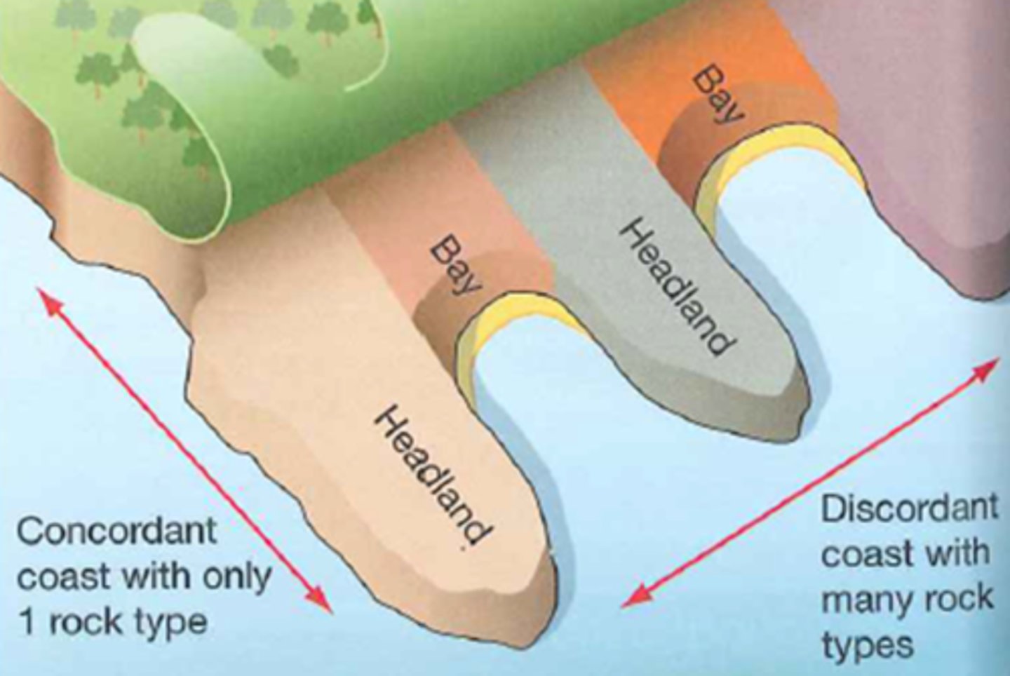
types of coastlines- concordant
· Concordant- alternating layers of hard and soft rock that run parallel to the coast.
· The hard rock, such as limestone, acts as a protective barrier to the softer rock (clays) behind it preventing erosion.
· If the hard rock has an area of weakness, such as a stream or a fault then marine processes (eg: hydraulic action and abrasion) will erode it away exposing the soft rock behind.
· This means that the marine processes will now be able to erode the soft rock which is less resistant to erodes faster than the remaining hard rock.
· This will continue until another band of hard rock is reached creating a circular shape in the coastline called a cove. E.g. Lulworth Cove
types of coastlines- discordant
· alternating layers of hard and soft rock are perpendicular to the coast.
· This means that the different rock types are exposed to marine processes at the same time (eg: hydraulic action and abrasion). Soft rocks like clay are less resistant so erode faster than the hard rocks such as granite.
· This differential erosion creates headlands where the rock is resistant and bays where it is less resistant.
· Waves are then refracted and focus their energy on the ends of the headlands which means that landforms of erosion are created such as caves, arches, stacks/ stumps and cliffs with wave cut notches and wave cut platforms.
Example: Swanage bay
describe waves on the discordant coastlines
Waves are usually parallel to the coastline
However as they approach shallow water the height increases and the base of the wave slows due to friction.
Wave energy is focused on the headlands in the shallow water
This is called refraction as the more powerful part of the wave is then concentrated on the head land leading to erosion
where is the dalmatian coast
The Dalmatian Coast, located along the eastern Adriatic Sea in Croatia, is a classic example of a concordant coastline
how was the dalmatian coast formed
· The Alpine Orogeny was a major period of mountain building (around 65-2.5 million years ago) caused by the collision of the African and Eurasian plates.
· This collision compressed and folded the rock layers in the Dalmatian region, creating alternating ridges (anticlines) and valleys (synclines).
· The anticlines (upward folds) were made of harder limestone, while the synclines (downward folds) contained softer rock.
describe sea level rise after the devensian glacial- dalmatian coast
· The Devensian Glacial (last Ice Age, ending ~10,000 years ago) caused global sea levels to be much lower because water was stored in ice sheets.
· When the Ice Age ended, glaciers melted, leading to a rise in sea levels.
· The rising sea flooded the synclines (valleys) where softer rock had been eroded away.
· 3. Formation of the Dalmatian Coastline
· The hard limestone anticlines remained above water, forming narrow, parallel islands.
· The former synclines became submerged, forming narrow sea channels (called sounds).
· Since the geological structure is parallel to the coastline, the Dalmatian Coast became a classic concordant coastline, where erosion works along rock layers rather than cutting across them.
describe the haff coast
· These are created by the deposition of unconsolidated material
● - low land coast where long bars and lagoons run parallel to the shore such as southern shore of the Baltic sea has Vistula Haff which is a large lagoon.
how was the haff coast formed
· During the Devonian ice age sea level was approx. 100 m lower than today. Meltwater rivers from the ice sheets deposited thick layers of gravel onto the tundra plains (sandurs). As sea levels rose constructive waves pushed the sediment landwards. Sand/ gravel ridges formed across some bays and river mouths trapping river water behind them creating a lagoon (called haffs in Poland's coast on the Baltic Sea)
· Other examples Neman Haff-Kaliningrad in Russia and Chesil beach in Dorset UK
describe geological structure
Rock formation and tectonics leads to anomalies forming within rocks (micro features). These create areas of weakness which lead to more rapid weathering and erosion.
There are different types:
Joints
Folding
Faults
● Rock formation and tectonics leads to anomalies forming within rocks) micro-features. These create areas of weakness which lead to more rapid weathering and erosion.
● Micro-features: joints, faulting and faults.
During the process of rock formation, pressure and cooling may crack a rock to form crevices, joints or larger faults. Joints are made as sedimentary rocks are formed by pressure or as igneous and metamorphic rocks cool. In sedimentary rocks there are also usually bedding planes between the different layers of deposition
describe joints
· Joints are created as igneous or metamorphic rocks form and cool down (cooling cracks).
· Joints are vertical. Bedding planes are horizontal.
describe folding
Happens when rock is put under stress and becomes permanently deformed without breaking (also known as dip
describe faults
· These are caused when pressure actually fractures the rock. It often occurs suddenly resulting in earthquakes.
what are bedding planes
● · Sedimentary rock is formed by pressure. This creates bedding planes between different layers in the rock.
Geology determines cliff profiles and bedding planes
● Sedimentary rocks contain bedding planes
o Surfaces of exposure between deposition events in ancient oceans and rivers
● Alignment of bedding planes can be altered by tectonic affecting rates of erosion.
Sedimentary= weakest + fastest to erode
what effects do joints, folds and faults have on coastal topography
The micro features of the geology will affect the weathering and erosion rates and therefore the CLIFF PROFILE
describe horizontal dip cliff profile
vertical or near vertical profile with notches reflecting strata that are more easily eroded
📍 Case Study: Flamborough Head, UK (chalk cliffs)
Hard chalk rock resists erosion.
Wave-cut platforms form at the base.
Weathering & erosion create caves, arches, stacks, and stumps.
describe seaward dipping
📝 Characteristics:✔ Rock strata dip seaward, making cliffs unstable.✔ Prone to rockfalls and landslides.✔ Waves undercut the cliff, increasing collapse risk.
📍 Case Study: Jurassic Coast (Dorset, UK)
Limestone and sandstone layers dip seaward.
Rockfalls and landslides common at places like Durdle Door.
Erosion removes collapsed material, causing rapid retreat.
describe landward dipping
Characteristics:✔ Rock layers dip inland, forming stable cliffs.✔ Slower retreat as rock supports the structure.✔ Steep, resistant cliffs with less collapse.
steep profiles of 70-80 degrees producing a very stable cliff with reduced rock fall
📍 Case Study: South Wales (Carboniferous Limestone Cliffs)
Limestone layers dip inland, preventing large collapses.
Strong, tall cliffs due to resistant geology.
fewer mass movements but wave cut notches still form
describe tidal energy
Tides are formed by the gravitational pull of the Moon acting on water on the Earth's surface.
Tides are produced as a bulge of water rotating around locations in the ocean.
As the bulge passes a location on the coast, high tide occurs. This happens twice a day with roughly 12-hour intervals.
In many locations the tidal range is very small, perhaps 1-2 metres.
what are tides
Tides are the regular rise and fall of sea levels caused primarily by the gravitational forces exerted by the Moon and, to a lesser extent, the Sun.
how do tides work
Gravitational Pull of the Moon: The Moon's gravity pulls on Earth's oceans, causing water to bulge out on the side of Earth facing the Moon. This creates a high tide in that area.
Opposite Side High Tide: Simultaneously, another high tide occurs on the side of Earth opposite the Moon. This is due to the fact that the Moon's gravitational pull is slightly weaker on the far side, causing the water there to "lag behind," resulting in a bulge.
Low Tides: Areas between these bulges experience low tides. As Earth rotates, different regions pass through these high and low tide zones, leading to the regular rise and fall of sea levels.
role of the sun in tides
The Sun's gravitational influence also affects tides, though its effect is less pronounced than the Moon's due to its greater distance from Earth.
Spring Tides: When the Sun, Moon, and Earth align during full and new moons, their combined gravitational forces lead to especially high and low tides, known as spring tides.
Neap Tides: When the Sun and Moon are at right angles relative to Earth during the first and third quarters of the lunar cycle, their gravitational forces counteract each other, resulting in neap tides, which have a smaller tidal range.
what is the influence of earth's rotation
Earth's rotation and the shape of coastlines influence the timing and height of tides. For instance, funnel-shaped bays can amplify tidal ranges, leading to phenomena like the Bay of Fundy's exceptionally high tides
significance of tides in coastal processes- tidal bores
Where the tidal range is large it can produce waves capable of erosion, called tidal bores, e.g. Severn Estuary in the UK (15m+ tidal range).
what are spring tides
When storms occur at the same time as spring tides (the highest tides), storm waves will act on parts of the coastline that do not normally experience them, dramatically increasing the risk of coastal flooding
describe rates of coastal recession
· Rate of recession- speed at which the coastline is moving inland.
· It is caused by physical factors (geological and marine) but can be influenced by human factors (dredging or coastal management) but the main physical factor is lithology.
rock types and their rate of recession- igneous
such as granite, basalt and dolerite have very slow recession rates at less than 0.1cm per year. The crystalline structure (interlocking crystals) makes the rock resistant and with few joints (micro features) means there are limited weaknesses to exploit
rock types and their rate of recession- metamorphic foliated
such as slate, schist gneiss has slow recession rates at 0.1-0.3 cm per year. Metamorphism can cause foliation (when the crystals are rearranged and line up facing the same direction). This produces weaknesses that can speed up recession. Rocks are often folded and heavily fractured producing weaknesses
rock types and their rate of recession- non foliated
such as marble and quartzite have slow rates of recession at 0.1-0.3 cm per year. Metamorphism can cause the grains to recrystallize into a very solid interlocking network. these rocks are resistant and folding and faulting makes them less resistant than igneous rock.
rock types and their rate of recession- sedimentary
such as limestone, sandstone and shale have a moderate to fast recession rate at 5-10 cm per year. Most are clastic (composed of sediment particles becoming cemented together). Many cements are reactive and easily chemical weathered. Bedding planes and joints make them even more vulnerable to recession. Geological young rocks tend to be weaker.
describe formation of sediments and type of lithology- differential erosion
· Unconsolidated material- sediment which has not been cemented to make solid rock (lithification)
· Crystalline - Rocks made of crystals which interlock
· Clastic - made of sediment particle cemented together by lithification
· Pore water pressure - internal force within cliffs exerted by the groundwater with in them (in the interstitial gaps). The pores affect how permeable the rock is.
differential erosion- periglacial
Periglacial areas are those next to ice sheets or glaciers. If still cold they contain permafrost making the cliffs resistant. If the ice has retreated (end of the ice age) the meltwater will wash unsorted material over the land. Glacial till or Boulder clay is unconsolidated material
describe permafrost and what it consists of
permafrost is a layer of soil or rock that remains frozen for at least two consecutive years. It is found in periglacial regions, typically in polar and high-altitude environments. Permafrost consists of:
1. Active Layer: The top layer that thaws in summer and refreezes in winter. Its depth varies depending on temperature and soil composition. The movement of this layer during thawing causes solifluction, where soil slowly flows downhill.
2. Perennially Frozen Ground: The deeper layer that stays frozen year-round. It traps ice lenses, which expand and contract with temperature changes.
what 3 categories of permafrost are there
1. Continuous Permafrost: Found in the coldest regions, covering almost all the ground.
2. Discontinuous Permafrost: Occurs in slightly warmer areas, with patches of unfrozen ground.
3. Sporadic Permafrost: Found in the warmest periglacial areas, with isolated pockets of frozen ground.
These variations depend on temperature, vegetation, and soil composition
impacts of structure on erosion
· Rocks with many cracks, joints and bedding planes such as limestone are permeable which means that water can pass through the rock.
· Rocks with spaces or pores within them such as chalk are porous and also allow water to pass through them.
· Rocks that do not have any spaces or many joints such as granite are impermeable and do not let water into the rock.
· The presence or absence of water may affect weathering and mass movement (sub aerial processes).
Some types of rock contain soluble minerals and so are vulnerable to chemical weathering such as carbonation or hydrolysis
· Limestone is soluble in rainwater which becomes a dilute carbonic acid by absorbing CO2 from the air.
· Limestone rokcs contain calcium carbonate which slowly dissolves into calcium bicarbonate which is carried away in solution.
· Sea water also absorbs co2 from the atmosphere and when waves splash on limestone rocks the water dissolves the limestone to create small pits and pinnacles.
describe the effects of coastal vegetation on coasts
Plants act as stabilisers on many coastlines in several ways
· Roots bind sediments together
· When submerged plants provide a protective layer so sediments are not exposed to moving water
· Surface level- Plants also protect sediment from erosion by wind
· Coasts protected by plants = sand dunes, salt marshes, coral reefs and mangroves.
plant adaptations- halophytes
salt tolerant e.g. Mangroves
plant adaptations- xerophytes
- drought tolerant (salt water is drying and sand does not retain water) e.g. Marram grass
plant adaptations- psammophytes
grown in wind blown sand (can tolerate dry, salty conditions and being buried) e.g. Sea Holly
definition of plant succession, zonation, pioneer species and climax communities
· Plant succession - means the changing structure of a plant community over time as an area of bare sediment is colonised. Each step in this change is called a seral stage
· Zonation - how ecosystems change spatially away from the shoreline
· Pioneer species - the first hardy species to colonised areas of exposed sediment
· Climax communities - the final stage of succession with the greatest biodiversity (woodland in the UK)
describe sand dunes
● Material is from sea-bed and rivers.
● Fragile until thickly vegetated.
● Found wherever loose sand is blown.
Primary succession- occurs in lifeless areas e.g. recently glaciated areas or where there are newly formed dunes.
Secondary succession- where a previous ecosystem has been removed.
Psammosere- a succession on a sand dune system.
● Initially only a small number of species survive by new plant species modify the habitat by changing the chemical composition so other species succeed it.
Zonation is used to show the succession assuming the sand dune closest to the sea is youngest.
describe embryo dune pioneer plants and marram grass
● stabilise the mobile sand with their root systems
● reduce wind speeds at the sand surface, allowing more sand to be deposited
● add dead organic matter to the sand, beginning the process of soil formation.
Marram grass has roots of up to 3 m long that can tap water far below the dune surface. It can tolerate temperatures of up to 60 °C and grows up to 1 m per year, so can keep pace with deposition of wind-blown sand
what is the strand line
After extreme high tides or storms, sand is left far inland from the usual high-water mark. The environment is harsh, so only pioneer plants like Sea Rocket can grow here. Small dunes can form as sand builds up.
describe embryo dunes and fore dunes
●Sand starts to accumulate above the high tide mark. This creates a habitat for specialised grasses like Lyme grass.
Fore-Dunes
The dune grows higher, and rainwater reduces the salt in the sand. Marram Grass starts to grow, and its dead leaves add organic matter to the soil, improving its ability to hold water and nutrients. On the more sheltered side, plants like sea holly grow. Over time, more plant species can live here due to better soil conditions
describe white or yellow dunes and fixed dunes
Mosses begin to cover bare patches of sand between the Marram Grass.
Fixed Dunes
When vegetation fully covers the dunes, they are considered "fixed." The soil still has low nutrients, and the risk of plants drying out is high. If grazed by animals like rabbits, a grassland with species like Ladies' bedstraw forms. Without grazing, shrubs like brambles start to grow.
describe dune slack, dune scrub, dune heath, woodland
1.Low areas between dunes may collect water, which is often sandy. These areas receive nutrients from surrounding dunes and may have species like Natterjack toads or orchids.
Dune Scrub
If there are no grazing animals, tall woody plants such as birch trees start to grow in the dunes.
Dune Heath
If grazing is controlled, it prevents the growth of taller shrubs, creating a stable, but human-influenced ecosystem. This stage is called a plagio-climax.
Woodland
If conditions continue to improve, a climax ecosystem develops into a deciduous woodland, with trees like oak becoming dominant.
describe salt marshes
● common in low energy environments
● Tides and rivers bring fine sediment in and out as they are deposited they stick together (flocculation). These sediments are colonised by algae and pioneer species. Succession occurs as the conditions change over time.
● Pioneer species have to survive being covered by brackish water twice a day.
● Halophytic plants found such as samphire that can survive in salty conditions.
factors affecting salt marsh development- what is halosere
● weather, tidal regime, wave type, climate, sea level, human action, sediment type and river regime.
Halosere- a succession of a saltmarsh
how are salt marshes formed
● Low energy tidal environment required
● As tidal currents are slowed they deposit material
● Eel grass helps slow currents further
● Uneven mud flats that are exposed at low tide are colonised by pioneer species
● These plants are tolerant of salt and periodic soaking- halophytes e.g. sea blite
● Dense mat of 15cm vegetation
● Vegetation causes further slowing of tidal currents and dead biomass helps build up of sediment level
● Mud flats increase by 1mm-30mm a year
Eventually land rises above sea level
threats to salt marshes
● pollution, eutrophication, commercial shipping and recreational water sports, grazing, dredging and reclamation means that tidal ranges are narrower so less space for energy to dissipate.
Natural threats:
● Sea levels may rise too quickly for marshes to adjust
● Storms create greater wave energy and more potential erosion
● Changing temperatures and rainfall patterns