Wind Engineering - Finals
 Call Kai
 Learn
Learn Practice Test
 Spaced Repetition
 Match
Match Flashcards
 Knowt Play
1/220

There's no tags or description
Looks like no tags are added yet.
Name | Mastery | Learn | Test | Matching | Spaced | Call with Kai | Chat |
|---|
No analytics yet
Send a link to your students to track their progress
221 Terms
Air
aircrafts move through what
Ground
aircrafts move through air, not on __________
Wind
why is the atmosphere moving
Wind
continuously influences an aircraft's motion from takeoff to landing.
Ground Speed
directly affects flight time and fuel consumption.
Tailwinds
increase ground speed, reducing travel time and fuel burn.
Headwinds
decrease ground speed, increasing flight time and fuel consumption.
Crosswind
are among the most challenging weather conditions during takeoff and landing.
wind
motion of the surrounding air
Flight Vector Analysis
combines these motions (aircraft motion, and the wind) to determine the aircraft's actual movement over the ground, making it a fundamental tool for safe, accurate, and efficient aircraft navigation.
Compass Rose
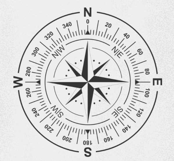
True North
reference of the compass rose
True Bearing
Angle measured clockwise between the True North and the Target as observed from own vessel
Relative Bearing
Angle measured clockwise between the Ship's heading and the Target as observed from own vessel
True Bearing
is measured clockwise from geographic True North (the Earth's axis of rotation).
Magnetic Bearing
is measured clockwise from Magnetic North (the direction a magnetic compass needle points).
True North
the Earth’s axis of rotation
Magnetic North
direction a magnetic compass needle points
Magnetic North
the magnetic bearing is measured clockwise from _________
Magnetic Declination or Variation
difference between the true bearing and a magnetic bearing
Magnetic Declination or Variation
changes depending on location
True Bearing
Reference Point: Geographic North Pole.
Used In: Nautical charts, aviation flight plans, and surveyed property maps.
How to Find: Usually calculated using a gyrocompass, GPS, or by applying a correction (declination) to a compass reading.
Magnetic Bearing
Reference Point: Magnetic North Pole.
Used In: Hiking, standard handheld compass navigation, and basic topographic maps (which often include a declination diagram).
How to Find: Read directly off an unadjusted magnetic compass.
Whole Circle Bearing System
Measured clockwise from True North
Values range from 000° to 360°
Quadrantal Bearing System
Expressed from North or South toward East or West
Always less than 90°
Heading
direction in which the aircraft’s nose is pointing
Heading
measured relative to North
Heading
determined by the pilot
Heading
may not be the actual direction of travel
Track (Ground Track)
actual path the aircraft follows over the ground
Track
affected by wind
Track
‘where I actually went’
Course
intended direction of flight over the Earth’s surface
Course
the planned route
Course
‘where I want to go”
Bearing
direction from one point to another, measured from North
Course
The horizontal direction in which a vessel is intended to be steered.
Heading
The direction in which the vessel is actually pointing.
Bearing
The direction of a fixed object from the vessel.
Aircraft Velocity
speed and direction of the aircraft relative to the surrounding air
Wind Velocity
speed and direction of th moving air
Ground Velocity
actual speed and direction of the aircraft relative to the Earth’s surface
Aircraft Velocity
velocity controlled by the pilot
Wind Velocity
velocity determined by atmospheric conditions
Ground Velocity
velocity observed by GPS and navigation systems
Triangle (Head-to-tail) Method
vectors are drawn sequentially. Thebtail of each new vector begins at the head of the previous vector.
Parallelogram Method
two vectors are drawn from the same starting point (tail-to-tail). A parallelogram is completed, and the diagonal represents the resultant vector.
Drift Angle
measure of deviation from the original flight course
Wind direction
is a major factor on active runway selection
Headwind
increases the drag force and eases landing and increases lift force eases take off
150 A.D.
when was the first recorded use of anemometers
Anemoscopes
Anemometers
2 (1 way each) to measure Direction and Speed
Dracones
dragon-shaped or conical fabric banners used by Roman Cavalry
Dracones
were attached to poles and allowed to inflate.
Dracones
served a dual purpose: they helped soldiers identify unit positions, and their open-ended design showed troops the speed and direction of the wind.
This was critical for archery tactics such as for adjusting and coordinating the trajectory of their arrows volleys.
Takeoff Performance
focuses on how far an airplane must travel on the ground and in the air before it is safely airborne
Takeoff Performance
It involves acceleration from rest to liftoff, and it's especially critical when considering engine failure or obstacles ahead.
Ground Roll
Distance the airplane travels on the runway before it lifts off.
Ground Roll
Starts at zero speed when brakes are released and engines go full power.
Airborne Distance
After liftoff, the airplane continues to fly low over the ground until it clears a specific obstacle (usually 35 ft for commercial aircraft, 50 ft for military).
Vstall (Stall Speed)
The minimum speed where the wings can start generating enough lift.
Below this, flight is impossible.
Vmcg (Minimum Control Speed on Ground)
For multiengine planes, this is the lowest speed where the pilot can still control the airplane on the ground if one engine fails.
Vmca (Minimum Control Speed in Air)
Similar to Vmcg but applies when the airplane is off the ground.
V1 (Decision Speed)
Critical speed where the pilot must decide:
If engine fails before V1, abort the takeoff
and if engine fails after V1, continue the takeoff—it’s still safe.
VR (Rotation Speed)
Speed where the pilot pulls the nose up (rotates the aircraft) to begin liftoff.
Vmu (Minimum Unstick Speed)
The lowest speed the airplane can actually lift off, assuming maximum safe rotation.
VLO (Liftoff Speed)
The actual speed at which the airplane leaves the ground.
Slightly higher than Vmu for safety and comfort.
Landing Performance
is the study of how much distance an aircraft requires to safely land, from the moment it clears an obstacle (typically 50 feet above the ground) to the point where it comes to a complete stop on the runway.
Total Landing Distance
is the entire distance needed to land safely starting from a point 50 feet above the runway down to a full stop on the ground.
Approach Distance
is the segment where the aircraft descends from a 50-foot obstacle height toward the runway on a shallow glide path.
Flare Distance
is the part of the landing where the aircraft transitions from a steady descent to a level attitude just before touchdown.
Ground Roll
is the distance an aircraft travels on the ground after touchdown until it comes to a complete stop.
Range
refers to the maximum distance an airplane can travel on a single trip without needing to refuel.
Range
refers to the maximum distance it can travel on a single trip without needing to refuel.
Propeller
type of aircraft that excel in short-range, regional flights with better fuel economy at lower speeds
Jet
type of aircraft that are built for high-speed, long-distance travel
Endurance
maximum time an aircraft can remain in steady flight using a given amount of fuel.
Cruise
during __________, endurance depends on how efficiently the aircraft uses fuel over time and not how far it travels.
Endurance
during cruise, __________ depends on how efficiently the aircraft uses fuel over time and not how far it travels.
Max Endurance
happens at minimum fuel flow, usually at low speeds and high L/D ratio.
Propeller Aircraft
are typically optimized for endurance over jets.
Jet Endurance Formula
is designed for aircraft flying at higher speeds and altitudes, where thrust is the dominant factor in fuel burn.
Wind Engineering
a vital field in aerospace that studies the relationship between atmospheric winds and aircraft performance.
Wind
defined as the movement of air relative to the Earth's surface, significantly influences aircraft operations during all phases of flight; takeoff, landing, and cruise.
Wind
is characterized by its speed and direction, which can be steady (constant) or turbulent (gusty).
Headwind
Wind blowing opposite to the aircraft's direction of travel, increasing lift and reducing ground speed during takeoff and landing.
Tailwind
Wind blowing in the same direction as the aircraft, decreasing lift and increasing ground speed, which can extend runway requirements.
Crosswind
Wind perpendicular to the aircraft's path, requiring precise control inputs to maintain directional stability, particularly during landing.
Wind Shear
A sudden change in wind speed or direction over a short distance, posing significant hazards during critical flight phases.
Headwinds
help airplanes take off and land in a shorter distance.
Tailwinds
make takeoff and landing longer and riskier.
Crosswinds
require pilots to adjust controls to stay straight on the runway.
Wind Shear
can cause sudden speed changes, making flying harder.
Headwinds
slow the plane down, increasing fuel use.
Tailwinds
speed the plane up, saving fuel.
Headwind
improves takeoff and landing by increasing airflow over the wings, allowing lift at lower ground speeds.
This shortens takeoff and landing distances and enhances control, making headwinds beneficial for safe and efficient aircraft operations.
Headwind
increases airflow over the wings, allowing lift-off at a reduced ground speed
Headwind
reduces horizontal distance covered during climb, enhancing obstacle clearance.
Headwind
lowers groundspeed, significantly reducing kinetic energy and braking distance.
Tailwinds
during takeoff and landing increase the aircraft’s groundspeed, leading to longer runway distances and reduced safety margins.