global hazards - plate tectonics shape our world
1/20
There's no tags or description
Looks like no tags are added yet.
Name | Mastery | Learn | Test | Matching | Spaced |
|---|
No study sessions yet.
21 Terms
structure of the earth
centre = core - inner core = made of solid iron and nickel, almosy 7,000 km below the earths surface, outer core reaches temperatures of 6000’c
around the core = mantle, semi molten rock that moves very slowly
outer layer = the crust - 10-70 km thick
oceanic crust = 10km thick, much denser, basalt and younger/newercontinental crust = 30-50km thick, granite and older
the crust is divided into tectonic plates that float on the mantle
why do the tectonic plates move
tectonic plates move due to convection currents on the mantle
the lower parts of the mantle are sometimes hotter than the upper parts
when these lower parts heat up they become less dense and slowly rise
as they move towards the top of the mantle they cool down, become more dense and slowly sink, the tectonic plates move on top of this
destructive plate boundary
denser oceanic plate (nazca plate) is forcibly subducted under the continental plate (south American plate) , the oceanic plate bends and a deep ocean trench is formed
as the plates drag against each other in subduction, they crack and fold, triggering earthquakes
if the plates then stick, lots of pressure builds up, when the plates finally break free a huge amount of energy is released - causing a deep focus earthquake e.g. large earthquake in the Maule region of Chile in 2010
how do destructive plate boundaries cause volcanic eruptions
as the oceanic plate subducts into the hot mantle, the much cooler seawater helps it to melt.
the water makes the melted mantle less dense, so it rises up the cracks in the continental plate as volvanic eruptions
the trapped water heats up and escapes as steam making the eruptions very explosive. (Calbuco volcano in Chile erupted 3 times in April/May 2015)
collision plate boundary
when two continental plates push against each other they collide (Indian and Eurasian Plates) this s because theyre less dense than the mentle beneath them. (no subduction/volcanic activity)
the continental crust thickens and the surfave lifts into fold mountains (Himalayan mountain range)
the pressure built up b ythe lates pushing against each other causes the crust to crack into faults, triggering shallow focus earthquakes
(devastating earthquakes occur in the HImalayan mountain region - e.g. Nepal April 2015)
constructive plate boundary - when oceanic plates pull apart
when oceanic plates pull apart
under the ocean, the partially melted mentles comes up in cracks in the oceanic crust called fissures (or erupt from volcanoes as lava
at the crusts surface, the lava constructs a new crust, over time this forms chains of mid-ocean ridges under water
(e.g. the Mid-Atlantic Ridge was formed by the Eurasian and North American plates)
constructive plate boundary - when continental plates pull apart
on land, when the partially melted mantle rises, it heats the plates above causing them to expand and bulge. this forms highlands
as the plates stretch, they fracture along fault lines, leading to fallen blocks of lowland forming rift valleys
an example of this is the Arabian plate pulling away from the African plate - causing the Great African Rift Valley to form
conservative plate boundary
tectonic plates move past each other
though in some boundaries they move in different directions, and others in the same direction but at different speeds (e.g. the San Andreas Fault)
the plates move in jerks - they can be locked together for years building up pressure. when they suddenly break free - the release of the stored energy causes earthquakes (e.g. the 2004 Parkfield earthquake caused by the San Andreas Fault suddenly moving 50cm)
causes of earthquakes
the most powerful earthquakes occur at destructive or collision plate boundaries
if the plates stick - huge pressure builds up, when the plates break free/one plate gives way, the energy released causes an earthquake beneath the earth’s surface at the focus.
fast waves of energy causes seismic waves, spread out from the focus through rock - they reach the surface at the epicentre directly above the focus
the amount of shaking felt at the surface depends on the depth of the focus, distance from the epicentre and geology.
after the main quake there are a series of smaller tremours called aftershocks
measuring an earthquake
richter scale - uses magnitude and is a logarithmic smale so an increase of 1 means the quake is 10 times more powerful, it is measured on a scale of 1-10
mercalli scale - uses intensity and the effects/damage, scale ranges from I to XII
deep focus earthquakes
start 70-700km below the Earth’s surface. they’re triggered by destructive plate boundaies only, they can be very powerful, but the seismic waves spread out vertically, so only a small area suffers damage
example: 2013 Okhotsk Sea earthquakes was 609 km deep, with a magnitude of 8.3 and mainly affected Russia
shallow focus earthquake
start within 70km of the Earth’s surface. they occur at conservative plate boundaires, and in the upper part of destructive/collision boundaries
they’re usually small and can’t be felt, but the seismic waves spread out horizontally so they cause damage over a larger area
example: 2015 Nepal Earthquake had a focus of 15km but a magnitude of 7.8
factors affecting the severity of earthquakes
level of economic development
time of day
geology - softer rock e.g. clay and sand will shake more easily
location (urban/rural, mountainous/flat land)
government and authority preparedness
debth of focus
techological developments to mitigate the impacts of a tectonic hazard
TransAmerica building in LA - built with many of these designs
Earthquakes cannot be reliably predicted in advance, but networks of seismometers and lasers can be used to monitor earth movements in areas at risk of earthquakes.
- These can give small (a few seconds or minutes) but vital amount of warning before a large earthquake occurs.
- Early warning systems mean that warnings can be communicated quickly and automatically to people and control systems when shaking is detected, using the internet, SMS networks and sirens.Buildings can be designed to withstand earthquakes e.g. used reinforced concrete or building special foundations that absorb an earthquake's energy.
- Existing buildings and bridges can be strengthened (e.g. by wrapping pillars in steel frames)
- Pipelines can be designed to flex and not break during earthquakes. This helps to prevent deaths and damage to property caused by flooding and firesIn LIDC countries technology isn't always affordable - In Haiti concreate homes collapsing contributed to 220,000 people dying in the quake as the government could not afford EQ proof buildings and corruption meant they were not built to regulation
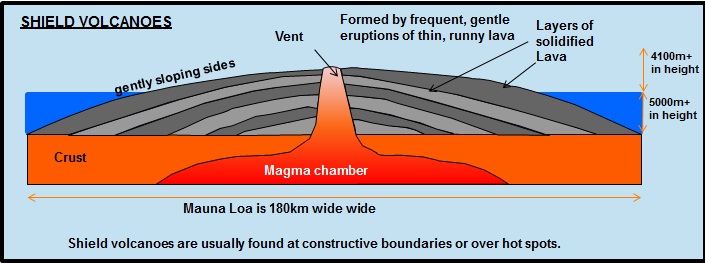
shield volcanoes
Found at constructive plate boundaries - where the mantle rises to the surface as the plates pull apart --> this lowers the pressure on the hot rock, which partially melts and becomes runny.
It doesn't trap gases and nothing plugs the volcano, so eruptions are gentle.
They also occur at hotspots, which aren't on plate boundaries, but where oceanic crust is very thin.
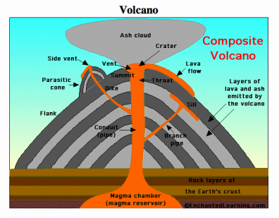
composite volcanoes
They're formed at destructive plate boundaries.
The partially melted mantle that rises is viscous, it contains trapped seawater and hot gases --> this builds up pressure. When its released suddenly, steam and dangerous gases erupt violently and the sticky lava cools quickly (flowing slowly) forming steep slopes.
The alternate layering of lava and ash creates composite volcanoes.
hotspots
A hotspot is a bit of the Earth's crust that is hotter than normal. They occur where a plume of hot magma from the mantle moves towards the surface, causing an unusually large flow of heat from the mantle to the crust.
Sometimes the magma can break through the crust and reach the surface. When this happens, there is an eruption and a volcano forms.
Hotspots can be found in oceanic or continental crust, and can be near or far from plate boundaries
Hotspots remain stationary over time, but the crust moves above them. This can create chains of volcanic islands, e.g. Hawaii is a chain of volcanic islands in the middle of the Pacific plate.
Tectonic Event - Nepal Earthquake 2015
25th April 2015, hit Kathmandu.
Caused by the Indian and Eurasian plates colliding.
7.8 magnitude (on the Richter scale) earthquake
Shallow focus - 15km
It was the worst earthquake in Nepal in more than 80 years.
The Gorkha earthquake was caused by the convergent plate margin between the Eurasian and the Indian tectonic plates. Nepal is located on top of the plate margin, making it prone to earthquakes. The geological structure of the valleys in Nepal (where the sediment is soft due to previous lakes) also increases the risk of earthquakes and amplifies seismic waves (which makes the impact of earthquakes more significant).
Effects of Nepal Earthquake 2015
Damage cost $10 billion.
Hundreds of thousands of people were made homeless.
Historical old cities were destroyed including temples and towers.
Harvests reduced or lost this season.
1.7 million children had been driven out into the open.
Landslides were caused by the earthquake.
8632 people died.
The earthquake massively reduced tourism over the long term, which greatly devastated the economy.
19,009 were injured.
An avalanche was triggered on Mount Everest.
Over 180 buildings were reduced to rubble in Kathmandu.
Short-term responses - Nepal Earthquake 2015
Tent cities sprung up in Kathmandu.
The responses were slow due to lack of money and resources.
90% of soldiers from the Nepalese army were sent to help in the worst hit areas.
On May 1st international aid agencies like Doctors Without Borders and the Red Cross started to evacuate the medical critically patients via helicopter.
International aid was provided by India and China who spent over $1 billion to help Nepal.
The UK offered help and support by sending over 100 search and rescue responders, medical experts, and disaster and rescue via three Chinook helicopters for use by the Nepali government.
Long-term responses - Nepal Earthquake 2015
The Asian Development Bank (ADB) provided a $3 million to Nepal for relief efforts; and $200 million for rehabilitation.
A new government taskforce was created to help deal with future earthquakes.
People are now being educated across Nepal to do earthquake drills.
Two years after the quake, only about 28,000 (3.4%) of those homes and buildings that qualified to receive government assistance for reconstruction – had been rebuilt. A year later, about 113,000 (13.7% of the total) were rebuilt.