Lecture 11 Midlatitude Weather and Climate
1/14
There's no tags or description
Looks like no tags are added yet.
Name | Mastery | Learn | Test | Matching | Spaced |
|---|
No study sessions yet.
15 Terms
Isobars
every 4 millibars on surface pressure charts
Airmass Characteristics (6)
a large body of air that has uniform horizontal properties of
temperature (either warm or cold)
moisture (either dry or moist)
horizontal extent = thousands of kilometres
extend vertically throughout the troposphere
have the properties of their source regions
move slowly from source region but are modified en-route
boundary between two airmasses is called a front
Airmass Source Regions
c -> continental, dry
m -> maritime, wet
P -> polar, cold
T -> tropical, warm
A -> arctic, very cold
e.g. cT, mP, A
British Airmasses and Fronts (6)
affected by a series of fronts, usually separating polar maritime and tropical maritime air
Arctic Maritime (mA), brings snow in winter
Polar Continental (cP), hot air brings dry summers, cold air brings snow in winter
Polar Maritime (mP), brings cold showery weather
Returning Polar Maritime (mP), brings clouds and rain showers
Tropical Maritime (mT), brings clouds, rain, and mild weather
Tropical Continental (cT), bring hot weather in summer
Fronts (7)
transition zone between two airmasses
extends vertically through troposphere
temperature contrast on either side of front
air converges on either side of the front to produce strong winds
warm air rises over cold air at a front
as the air rises it cools and condenses to form clouds and produce rainfall
surface pressure lowers
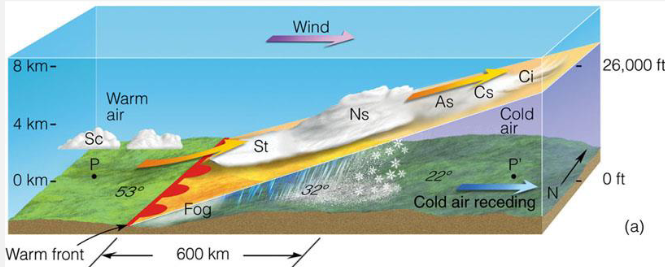
Warm Fronts (5)
occurs when a warmer airmass catches up to a colder airmass
warm moist air rises, condenses producing clouds and precipitation ahead of and at the surface front boundary
clouds are thicker and lower nearer to the front boundary and extensive
gentle slope -> ~1:150 - 1:200
speed -> 25 km/hour
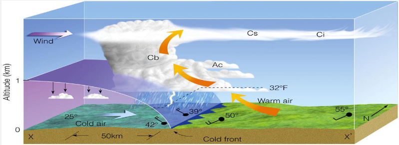
Cold Fronts (6)
occurs when a colder airmass moves into a warmer airmass
warm moist air condenses into high clouds ahead of the surface front boundary
uplift more rapid than for warm fronts, cumulonimbus form
thick clouds, narrow, short-lived band of precipitation (can be thunderstorms) close behind front boundary
steep slope -> 1:50 - 1:70
speed typically twice as fast as warm fronts -> 50 km/hour
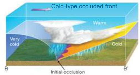
Occluded Fronts (6)
low pressure front, storms
occur where warm and cold fronts meet
cold front moves about twice as fast as warm front and catches up to warm front
rising air along occluded front with cold air either side
part of life cycle of mid-latitude cyclone
low pressure centre of mid-latitude cyclone at tip of occluded front as rising air lowers mass of air column
Mid-Latitude Cyclones (5)
area of low pressure in the mid-latitudes associated with warm, cold, and occluded fronts
brings stormy weather
air converges at surface
cyclonic motion
anticlockwise in NH, clockwise in SH
typically form between 30-60° along polar front
boundary between cold polar air and warm tropical air
above the polar front is the polar front jet stream
strong winds
Mid-Latitude Cyclone Characteristics (5)
motion: ~1000 km/day
size: ~2000 km/day
lifetime: ~5 days
pressure gradient: ~35hPa/1000km
central pressure: ~959hPa
Cyclone Formation
situation of converging surface air and divergence aloft
if upper-level divergence is stronger than surface convergence -> surface pressure drops -> surface low deepens
UK Storm Centre
Met Office website set up for winter 2015/2016
to raise awareness and aid communication of approaching severe weather through media and government agencies
storms named when they had the potential to cause an amber ‘be prepared’ or red ‘take action’ wind/rain warning
Cyclone Case Study: Storm Eowyn (8)
January 2025, 22nd/23rd/24th
severe winds over Scotland and Northern Ireland
Red warnings issued for wind in these regions with amber warning covering the northern UK
wind gust speeds of over 80mph
‘the UK’s most powerful storm in a decade’
Jan 24th
6am, Eowyn off the coast of Ireland
very tight isobars = high winds
‘explosive cyclogenesis’
50hPa drop in 6 hours
due to interaction with the jet stream
intensified by cold temperatures in North America
deepened to 927hPa by 12pm
low pressure centre over the Central Belt with extensive clouds associated with fronts
lots of rain in the early morning, some continued in North
last storm with such gusts in 2014/2015
Storm Eowyn Impacts (4)
schools closed, transport disruption
fallen trees and debris
over 1 million homes in Scotland and Northern Ireland without power
2 fatalities
Storm Eowyn Wind Speeds (3)
58mph (50 knots) mean wind speeds across Northern Ireland and Scotland
81mph (70 knots) peak gust speeds at ~20 stations
92mph (80 knots) at ~5 station