Intro to Marine Navigation
1/31
There's no tags or description
Looks like no tags are added yet.
Name | Mastery | Learn | Test | Matching | Spaced | Call with Kai |
|---|
No analytics yet
Send a link to your students to track their progress
32 Terms
Mission Statement
maritime nation, protect at sea, keep seas open and free
Nautical Charts
Graphic representations of areas of the Earth, in digital or hard copy form, for use in marine
navigation.
Course
The horizontal direction in which a vessel is intended to be steered, measured from north at 000° clockwise though 360°.
Heading
The direction in which a vessel is pointed at any given moment, expressed as angular distance from 000° clockwise through 360°
Bearing
The direction of one terrestrial point from another, expressed as angular distance from 000° clockwise through 360°. Is expressed as either true or relative bearing
Speed
The direction of one terrestrial point from another, expressed as angular distance from 000° clockwise through 360°. Is expressed as either true or relative bearing
Lines of Position (LOP)
-A line that is plotted on a chart with which our position lies. It may be taken from a visual aid,
RADAR or a celestial sight reduction.
Fix
A position derived from measuring external reference points, typically the intersection of three or more LOPs
Prime Meridian
The base line of Longitude from which
all lines of longitude are measured from. Based in Greenwich, England and runs from True North to True South.
Longitude
The angular distance between the Prime
Meridian (base longitude) and the meridian of a point on Earth. Measured 000°-180° East or West of the Prime Meridian. Lines of Longitude are commonly referred to as meridians
Equator
A great circle at latitude 0° that bisects the
Northern and Southern Hemisphere.
Latitude
The angular distance from the Equator (base
latitude) measured north or south from 000°-90° at the poles. Lines of Latitude are commonly referred to as Parallels.
Rhumb Line
A line, typically drawn on a chart, that is making the same angle with all meridians. It has a path with constant bearing relative to true north. loxodromic curve or loxodrome.
Great Circle Line
A line that represents the circular intersection of
a sphere and a plane passing through the sphere’s center point
Dead Reckoning
Determines a predicted position by advancing
a known position for courses and distances
Piloting
Involves navigating in restricted waters with frequent or constant determination of position relative to nearby geographic and hydrographic features.
Radar Nav
Involves using RADAR to determine the distance from or bearing to objects whose position is known. This is separate from collision avoidance
Satellite Nav
Uses radio signals from satellites to determine position
Cel Nav
Involves reducing celestial measurements taken with a sextant to lines of position utilizing spherical trigonometry either by hand or with computer programs.
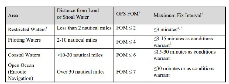
Restricted Waters
Navigating less than 2 nautical miles from land or shoal water, typically in narrow canals, channels, rivers and estuaries
Piloting Waters
Navigating within 2-10 nautical
miles of land or shoal, typically as we go to a
harbor entrance or through bays and sounds and negotiating harbor approach channels.
Coastal Waters
Navigating within >10-30 nautical miles of land or shoal water
Open Ocean
Navigating over 30 nautical miles away from land or shoal water.
Phases of Navigation
National Geospatial Intelligence Agency
Produces charts and nautical publications
used extensively by the U.S. Military. Disseminates maritime safety information in the form of Notice to Mariners (NTM).
United States Naval Observatory
Scientific and military facility that produces
geopositioning, navigation and timekeeping data for the United States Navy and the United States Department of Defense. It is one of the oldest scientific agencies in the United States, and remains the country's leading authority for
astronomical and timing data for all purposes
National Oceanic and Atmospheric Administration
Produces charts and nautical publications used extensively by both the Navy and Merchant fleets. Primarily covers the coastal areas of the US and Great Lakes.
USCG
Maintains aids to navigation, provides updates for Navigation Warnings for US Districts and
produces Local Notice to Mariners. Publishes the Rules of the Road book that we use!
National Oceanographic Officer
Provides oceanographic products and services to all elements within the Department of Defense.
International Hydrographic Organization
Sets forth hydrographic standards to be agreed
upon by member nations. Ensures nautical charts produced by different nations have uniformity in design
International Maritime Organization
Coordinates international policy on maritime
matters. Adopts conventions and protocols for
safety at sea, such as International Regulations for Preventing Collisions at Sea (COLREGS)…or the Rules of the Road!
International Association of Marine Aids to Navigation and Lighthouse Authorities
Provides technical coordination, information
sharing and coordination of improvements to
visual aids to navigation around the world.