APES Unit 4 - Earth Systems and Resources
1/72
Name | Mastery | Learn | Test | Matching | Spaced | Call with Kai | Chat |
|---|
No analytics yet
Send a link to your students to track their progress
73 Terms
what happens at Divergent Plate Boundaries?
Plates move away from each other
New crust is created here
Rising magma plume from mantle forces plates apart
what happens at Convergent Plate Boundaries?
Plates move towards each other
Two types of crust:
Oceanic- thin and dense
Continental -thick and buoyant
Often leads to subduction (one plate being forced beneath another)
what happens at Transform Fault Boundaries?
Plates sliding past each other in opposite directions
Earthquakes = most common activity
Occurs when rough edges of plates get stuck as they try to slide past each other
Pressure builds as plates keep sliding, but edges stay stuck
When stress overcomes the locked fault, plates suddenly release, slide past each other, and release energy that shakes the lithosphere
landforms occurring at Divergent Plate Boundaries
mid-oceanic ridges, seafloor spreading, and rift valleys
landforms occurring at Convergent Plate Boundaries
Mountains, Island arcs, Earthquakes, Volcanoes, Ocean trenches
landforms occurring at Transform Fault Boundaries
fault lines and rift valleys, earthquakes
where do Divergent Plate Boundaries occur
along mid-ocean oceanic ridges (although some are on land)
where do convergent Plate Boundaries occur
oceanic-oceanic lithosphere, oceanic-continental lithosphere, and continental-continental lithosphere
where do Transform Fault Boundaries occur
sea floor, where they connect segments of diverging mid-ocean ridges and san andreas fault
hot spot
areas of esp. hot magma rising up to lithosphere
Identify the types of landforms that typically occur over a hot spot.
Mid-ocean Islands Hawaii
Explain how hotspots are responsible for chains of islands.
High heat and lower pressure at the base of the lithosphere (tectonic plate) facilitates melting of the rock. This results in chains of volcanoes, such as the Hawaiian Islands.
Describe what subduction is. Be sure to mention the two plate types involved.
one plate being forced beneath another
(oceanic and continental)
Oceanic-oceanic (convergent boundary):
one plate subducts underneath another
forces magma up to lithosphere surface, forming mid oceanic volcanoes (island arcs)
oceanic-continental (convergent boundary)
dense oceanic plate subducts under contintental plate and melts back into magma
forces magma back up to lithosphere surface
continental-continental (convergent boundary)
one plate subducts underneath other, forcing surface crust upward (mountains)
Ex. Himalayas
Location where seafloor spreading creates new lithosphere. Why?
Divergent plate boundary - rising magma plume from mantle forces plates apart. often forming a mountain or elevated area of the seafloor. Eventually, the crust cracks
Location where subduction happens. Why?
convergent plate boundary - . When an oceanic plate collides with a continental plate, the denser oceanic plate is bent downward and slides under the edge of the continent.
Location where plate is moving over a hot spot. Why?
transform fault plate boundary
They move because of the convection in the mantle that also pushes around the plates above
Identify the two layers with the darkest color
Horizon O and A
Identify the two layers with the most nutrients
Horizon O and A
Explain why these two layers have the most nutrients
Topsoil is usually more fertile than the other layers and has the greatest concentration of plant roots.
A-Horizon has most biological activity (earthworms, soil microbes) breaking down organic matter to release nutrients
Identify the layer that contains the most parent material
Horizon C
Describe how parent material becomes soil
Weathering and Natural erosion:
the process of weathering breaks up parent material that is the foundation of soil. lichens secrete acid that breaks down rock and Humus is formed from dead, organic material, releasing nutrients and holding moisture
Describe how soil filters water
cleaned via physical, chemical and biological processes. In addition to soil's physical filtration capacity, soil contains important biota that helps transform and decompose certain chemicals and other contaminants from soil, thus helping filter them out of the water. the soil can hold onto pollutants—such as living organisms, harmful chemicals and minerals—and only let the clean water through.
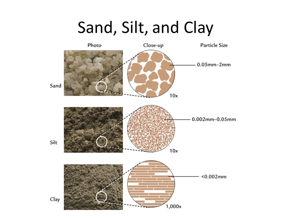
Describe what soil texture is. How is it measured?
the % of sand, silt, and clay in a soil
always adds up to 100%
soil texture chart (divide the depth of each layer of soil by the total soil depth in the jar, and multiply by 100)
Explain how soil texture determines porosity, permeability, and H2O holding capacity.
Soil texture describes the proportion of the soil particles and the fineness or coarseness of a soil. The texture of a soil determines soil water-holding capacity, permeability, and soil workability. Sand, silt, clay, and organic matter particles in a soil combine with one another to form larger particles.
identify which soil represented on the texture chart to the right would retain the most water
clay
Identify which soil would have the largest pore size
sand
List 4-5 essential soil nutrients needed for plant growth
N, P, K+, Mg2+, Ca+, Na+
the relative grain sizes for silt, sand and clay
Describe what the red line on the graph represents
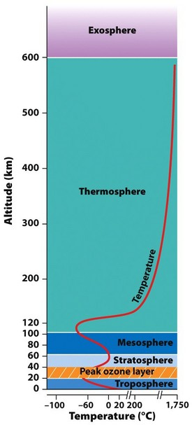
temperature
Identify the relationship between temperature and altitude for each layer of the atmosphere
In the troposphere, temperature decreases as altitude increases.
In the stratosphere, temperature generally increases as altitude increases due to the increased absorption of ultraviolet radiation by the ozone layer.
temperature increases as you gain altitude in the stratosphere and the thermosphere. Temperature decreases as you gain altitude in the troposphere and mesosphere
Why does the temperature in the troposphere decrease with altitude?
because it is warmed from below, through absorption and re-emission of incoming solar radiation by the Earth's surface
Identify the percentage of the atmosphere that each of the following gases makes up
N2: 78%
O2: 21%
H2O: 0.4%
CO2: 0.04%
Identify the relationship between altitude and pressure in earth’s atmosphere
decreases with higher altitude
List the layers of the atmosphere from most to least dense
thermosphere (least dense)
mesosphere.
stratosphere.
troposphere (most dense)
(decreases with higher altitude)
Identify the layer that contains the most ozone (O3)
stratosphere
Identify the layer that receives the most intense solar radiation
stratosphere
Identify the source of energy that drives global wind patterns
direct sunlight
Identify the relationship between air temp. & density
high pressure air mass contains cool dense air.
low pressure air mass contains low density warm air
low density warm air rises expands and cools
Identify the relationship between air temp. & moisture
Warm air holds more moisture than cold
Rising air expands & cools
Cool air can’t hold as much H2O vapor (condenses → rain)
After cooling & expanding, air sinks
what happens at step 1
More direct sunlight @ equator warms air
sun heats moist tropical air causing it to rise
what happens at step 2
Warm air rises, cools, and expands
H2O vapor condenses into rain
rising air experiences adiabatic cooling which causes water to condense into rain and fall back to earth.
what happens at step 3
Air continues to rise, cool, and expand
water vapor condensation produces latent heat release causing air to to expand and rise farther up into the atmosphere.
why deserts occur at 30o N & S
the heated equatorial air begins to descend. The descending air is dense and begins to warm again, evaporating large amounts of water from the land surface. The resulting climate is very dry.
Air at the equator rises and cools - condensation then forms rain. The air then moves north and south until it gets to about 30° north and south of the equator, where it sinks. This air is dry and no condensation can form, so there is no rain.
Describe why air moves back to the equator from 30o N & S
Due to the rotation of the earth, there is a build up of air at about 30° north latitude. (The same phenomenon occurs in the Southern Hemisphere). Some of the air sinks, causing a belt of high-pressure at this latitude. The sinking air reaches the surface and flows north and south.
The continual heating and rise of air at the equator create low pressure there, which causes air to move (wind) towards the equator to take the place of the air that rises. On the other hand, sinking air creates high pressure at the surface where it descends.
Identify why wind moves from east to west between 0o and 30o
coriolis effect
Identify the direction of wind movement between 30o and 60o degrees
west to east (westerlies)
What are some characteristics of a watershed that determine how runoff flows?
greater slope, soil permeability
Describe run-off and list pollutants that can enter bodies of fresh water from runoff.
Endocrine disruptors (from sewage treatment)
Sediment pollution (deforestation, urbanization, tilling ag. fields)
Increases turbidity (reduced photosynth) & covers over rocky streambed habitats
Describe the ecological role of riparian buffers
provide pollution reduction, erosion control, flood protection and wildlife value
Explain how storm water runoff can degrade water quality in streams, lakes, and coastal areas.
Runoff picks up fertilizer, oil, pesticides, dirt, bacteria and other pollutants as it makes its way through storm drains and ditches - untreated - to our streams, rivers, lakes and the ocean.
How does increased stormwater runoff reduce groundwater recharge?
more frequent flooding, higher flood peak flow, lower base flow in streams, and lower water table levels.
How does community growth and development change the land cover?
deforestation, along with urban sprawl, agriculture, and other human activities, has substantially altered and fragmented the Earth's vegetative cover.
albedo
the proportion of light that is reflected by a surface
Describe the relationship between albedo & surface temperature on earth
Surfaces with higher albedo reflect more light, and absorb less (ice/snow), Absorb less heat
Surfaces with low albedo reflect less light, and absorb more (water), Absorb more heat
Define insolation & the units used to measure it
incoming solar energy (W/m2)
Identify the relationship between latitude and insolation
Indirect relationship: as latitude increases, angle of insolation decreases
Why do we have seasons on Earth?
The earth's spin axis is tilted with respect to its orbital plane.
Identify the point when the equator receives the most direct insolation
equinox
identify the point when the N and S Hemisphere is maximally tilted toward the sun
june and december solstice
Describe the relationship between earth’s tilt and the solar intensity
A location receives its most intense radiation during summer, and its least intense radiation during winter. Summer occurs when a hemisphere is tilted towards the sun. This tilt causes the hemisphere to get more direct sunlight for more hours a day, and temperatures tend to be warmer.
identify the point when both N and S hemisphere receive 12 hours of daylight. Describe why this is
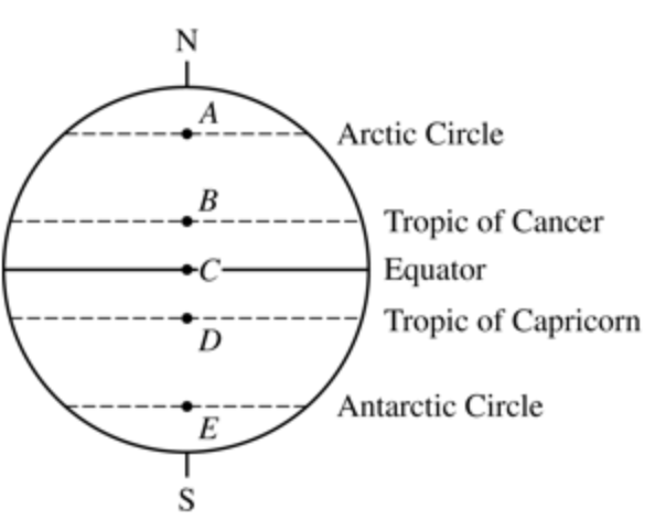
The equinoxes are the only time when both the Northern and Southern Hemispheres experience roughly equal amounts of daytime and nighttime.
Point C
Identify the point on the globe to the right that receives 24 hours of daylight on the Dec. solstice
Point E
Identify the point on the globe that receives the most direct insolation on the June solstice
Point D
Describe how mountains can influence the microclimate of a given region.
disrupt wind & produce rain shadow effect
Describe how ocean temperature can influence the climate in a given region.
moderate temperature & add moisture to the air
Explain what a rain shadow is
Warm, moist air from ocean hits the “windward” side of the mtn, rises, cools (condensing H2O vapor & causing rain) → lush, green vegetation
Dry air descends down “leeward” side of mtn, warming as it sinks
Leads to arid (dry) desert conditions
Windward (E) side of Andes receives heavy rainfall
Leeward (W) side of Andes receives arid (dry) air
Describe why water is the warmest at the equator
incoming solar radiation is about double that received at the poles.
why water moves away from the equator
Surface currents caused by winds
why water sinks and spreads across the ocean floor at the poles
the salt in the water at the poles of the earth cant freeze so cold salt water is left behind and sinks to the ocean floor while more water comes to replace it
upwelling
areas of ocean where winds blow warm surface water away from a land mass, drawing up colder, deeper water to replace it
Brings O2 & nutrients to surface → productive fishing