Ocean and Atmosphere Dynamics
1/94
Name | Mastery | Learn | Test | Matching | Spaced | Call with Kai |
|---|
No analytics yet
Send a link to your students to track their progress
95 Terms
where is the warmest ocean water located at
along the equator in the western ocean basins
where is the coldest water located at
near the poles
temperature of the atlantic ocean
warm thin surface layer
cold thick deep layer
thermocline separates the warm and cold layers
where is the saltiest water
in the subtropics
which ocean is the saltiest
atlantic
which ocean is the freshest
north pacific
deep ocean salinity at higher latitudes
more uniform and generally matches the surface salinity at higher latitudes, specifically northern high latitudes
how do large subtropical gyres rotate
rotate clockwise in the northern hemisphere and counter-clockwise in the southern hemisphere
how do smaller subpolar gyres rotate
counterclockwise in the northern hemisphere and absent in the southern hemisphere
deep ocean circulation
cold surface water sinks at high latitudes and moves to lower latitudes at depth
deep-water returned to the surface layer through broad diffusive upward vertical mixing
how to determine the direction of coriolis force
point your nose in the direction the ocean current (or wind) is moving
stick your hand directly out from your side to get the direction for the coriolis force
right hand for northern hemisphere and left hand for southern hemisphere
where is coriolis force acting on in the northern hemisphere
right of the water parcel motion
where is coriolis force acting on in the southern hemisphere
left of the water parcel
how is the atmosphere heated
the visible radiant energy from the sun (short wavelength radiation) passes through the atmosphere without being absorbed → earth’s surface absorbs a lot of the short wavelength sunlight energy so it becomes warm
warm earth surface radiates infrared radiation (long wavelength radiation) from its surface and is absorbed by the atmosphere. atmosphere is heated
how does atmospheric convection occur
warm ocean surface heats the atmosphere from below
warm surface air is able to hold a lot of water vapor so it becomes moist → it has low density so it rises and moves higher. it then expands and cools
cooling of air aloft causes water vapor to condense and precipitate
condensation releases latent heat that warms the surrounding air and drives the upward convection higher
where is the most intense solar heating
at the equator where solar radiation is the most direct
where is atmospheric convection and precipitation the strongest
along the equator
why is there a thick band of clouds along the equator
strong surface heating by the sun along the equator drives upward atmospheric convection, condensation and precipitation
is a column of high amounts of water vapor heavier or dry air?
dry air since N2 has a heavier molecular weight than H2O
what is the idealized hadley circulation
surface air at the equator warms and rises aloft. this air spreads north/south and becomes more dense as it cools and dries due to precipitation. it sinks and warms at about 30 degree latitude
warm and dry surface air at 30 degrees spreads out north and south, picks up moisture, by 60 degree latitude, it has moistened to the point where it rises, cools precipitates and spreads out aloft north and south
near the poles, the air aloft becomes very cold and dense so it sinks over the poles and spreads out towards the equator
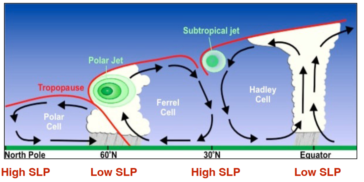
which latitudes have high sea level pressure
north pole and 30 degree latitude
which latitudes have low sea level pressure
equator at 60 degrees latitude
why should we worry about the vertical distribution of seawater density in the ocean
the vertical distribution of seawater density directly influences the vertical movement of water in the ocean
salt concentration and water temperature jointly determine seawater density so the concepts of ocean salinity and ocean heat content are presented in some detail
how does precipitation affect salt concetration
rain dilutes it
how does evaporation affect salt concentration
it concentrates salt concentration
what is surface ocean temperature is determined by
exchange of heat across the air-sea boundary
what is the most dominant method for the sea to lose heat
evaporative cooling
what is ocean temperature a measure of
heat energy contained in the ocean
surface ocean temperature in spring/summer for temperate ocean regions
more heat enters the ocean due to the sunlight than leaves so the surface ocean warms
surface ocean temperature in winter for temperate ocean regions
more heat leaves than comes in from sunlight so surface ocean cools
light penetration depth in the clearest open-ocean waters
up to 150-200 meters
light penetration in turbid coastal waters
light can only penetrate up to 50m
at which depth does most of the overall heating occur in
0-30 meters
how far does vertical mixing of near-surface water reach
mixing only reaches to at most ~500 meters
what is the temperature of seawater below 500 meters
uniformly cold
what is the permanent thermocline
broad region centered at around 500 meters where seawater temperature changes from warm to uniformly cold
seasonal thermocline
a much shallower thermocline that forms only in the summer and is erased in the winter
what is the typical vertical density profile
less dense water floats above more dense water
what is seasonal pycnocline
it is a region of strong change in density with depth
it comes and goes with net heat gained in spring/summer and net heat losses in fall/winter
ekman spiral
spiraling of thin ocean currents within the ekman layer
ekman transport
it is the rate of total water transported in the ekman layer (which is 50-100 meters thick)
derived by summing all the individual thin current sheets over the entire ekman layer
what is the angle of ekman transport to the wind direction
90 degrees to the right (northern hemisphere) or left (southern hemisphere) of the wind direction
response of fluid in the ocean due to the pressure gradient force and coriolis force
fluid first response to a pressure gradient force and moves down the pressure gradient to lower pressure
coriolis force pushes it to the right of its direction of travel
fluid continues to be pushed by coriolis until the coriolis force is equal and opposite of the pressure gradient force. the two forces cancel each other out so there is no acceleration of the fluid but there is also no friction to bring this steady motion to a halt
what is geostrophic balance
the point at which currents move with a steady speed, with coriolis and pressure gradient forces in perfect opposition
what is geostrophic current
resulting current from geostrophic balance
formation of subtropical gyres
if a mound of water builds up at the surface of the ocean, a central high pressure develops under the mound and circular geostrophic currents develop

what do the dark lines represent
contours of constant pressure that decrease away from the center of the mound region

what do the yellow arrows represent
direction of fluid motion for a northern hemisphere mound
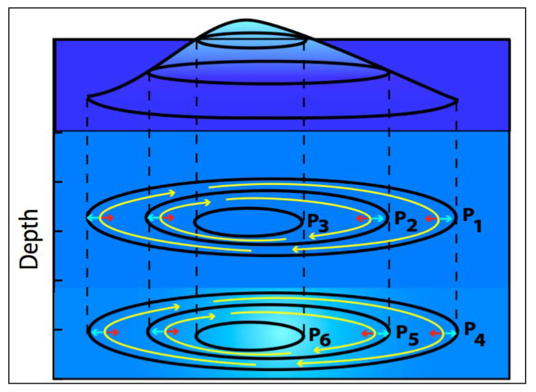
what do the light blue arrows represent
they point out the directions of the pressure gradient force, toward lower pressure

what do the red arrows represent
point out the coriolis force and are directed to the right of the fluid motion, and this case to the center of the higher pressure
combining ekman transport and geostrophic currents
subtropical gyres develop in response to the westerly and trade wind belts
westerly winds and trade winds drive the ekman layer to the center of the gyre to create a mound of surface water
center of high pressure develops under the mound of surface water
fluid initially moves away from the center of high pressure
the push of coriolis turns the fluid until it reaches geostrophic balance
how can you find the center of the subtropical gyre
if you put your nose in the direction of the trade winds and stick your right hand out, you will point to the center of the subtropical gyre
western boundary currents
currents on the western side of all subtropical gyres
very swift and narrow jets that bring warm water from the tropics to high latitudes
eastern boundary currents
currents on the eastern side of all subtropical gyres
broad and slow and bring cold water from the high latitudes toward the tropics
where is the center of the gyre
shifted slightly towards the west
which part of the subtropical gyre does the coriolis force point towards
center of high pressure
in the northern hemisphere, right hand rules apply so it requires a concentric clockwise motion to achieve a center directed coriolis force
a counterclockwise motion is needed in the southern hemisphere with its left hand coriolis rule
what is the seasonal variation of heating and cooling of the surface ocean at mid-latitude regions
march to aug: gaining heat
september - february: losing heat
what are the 2 foundational concepts of a subtropical gyre
ekman transport
geostrophic currents
direction travelled by ekman spiral
the top-most current moves at 45 degrees to the wind forcing because of wind, coriolis force and friction
bottom-most current moves directly opposite of the wind direction
equatorial upwelling
north east trade winds drive ekman transport to the north
south east trade winds drive ekman transport to the south
the “parting” of the surface water to the north and south means that deep water rises upward from the base of the ekman layer to the surface along the equator
surface water also piles up on the western side of the ocean, forcing a downward tilt to the thermocline
water is drawn up from the base of a relatively shallow ekman depth
what type of water is drawn up to the surface if thermocline is close to the ekman depth
cold
what type of water is drawn up when the thermocline is deep/further away from the ekman depth
warm
how did the eastern equatorial pacific cold tongue form
due to equatorial upwelling AND the close proximity of the thermocline to the ekman depth
how did the western equatorial pacific warm pool form
upwelling still occurs but thermocline is much deeper than the ekman depth so upwelling draws more warm water to the surface
coastal upwelling along the washington oregon coast
wind blowing out of the north drives ekman layer to the right (northern hemisphere) which is offshore
offshore transport of the ekman surface layer is replaced by upwelling of deeper cold water allong the coast
downwelling
wind blowing out of the south drives the ekman layer again to the right (because northern hemisphere) which is onshore
onshore transport of ekman surface layer is driven downward
atlantic ocean temperature at depth (meridional section from iceland to antarctica)
warm thin surface layer
cold thick deep layer
thermocline separates the warm and cold layers
atlantic ocean salinity at depth
high salinity in surface layer in subtropics
deep-ocean salinity more uniform and generally matches the surface salinity at higher latitude - especially northern high latitudes
temperature salinity of north atlantic deep water
close to 35 degrees celsius
and 1027.75% salinity
temperature salinity of antarctic bottom water
roughly 34.85 degrees celsius
and 1028.0% salinity
temperature salinity of antarctic intermediate water
roughly 34 degrees celsius and 1027.25% salinity
speed of circulation of deep water in the global ocean
cold dense water sinks in the north atlantic and around antarctica to form deep abyssal water
north pacific salinity is too low to sink (though temperatures are just as cold as north atlantic)
deep water in north atlantic moves south and merges with antarctic water in the southern ocean as they both swing around antarctica and up into indian and pacific basin
how old are the deepest waters and where are they found
2000 years old and in deep pacific
schematic of heat transport by the global conveyor belt circulation
heat is gained by the surface ocean at low latitudes and transported via the wind-driven surface circulation (western boundary currents) to higher latitudes
heat is given up by the ocean to the atmosphere at higher latitudes to warm these regions
surface water sinks and enters the thermohaline deep circulation and is returned to the surface to pick up more heat and the cycle repeats
what currents aid in most heat transport to high latitudes
strong western boundary currents
what is the result of winters due to global conveyor belt circulation
western europe experiences mild winters, relative to northern canada
westerly winds then carry warm coastal air over land
what is the level of AMOC circulation
weakest in more than 1000 years
AMOC collapse
recent analysis suggests that critical thershold is closer than the 2019 IPPC special report indicated
the bistable nature of the phenomenon means that it will find a new equilibrium in its off state and turning it back on would require a shift in the climate far greater than the changes that triggered the shutdown
what is el nino
the roughly periodic (3-7 years) occurrence of prolonged (ca. 8 months) warming of coastal waters off of peru and ecuador
idealized hadley circulation
winds at ocean surface
rush toward the equator
coriolis force turns the winds to cause them to blow from east to west (classic trade winds)
winds aloft
rush away from the equator
coriolis force turns the winds to cause them to blow from west to east (opposite of trade winds)
why does the east-west pattern of hadley circulation occur
differences due to unequal heating of land and ocean
land heats more strongly than adjacent ocean in summer and cools more than adjacent ocean in winter - due to differences in specific heat of rock and seawater
walker-circulation cell (east-west atmospheric circulation cell)
winds at ocean surface move toward the equator but are deflected by coriolis toward the west to form surface trade winds
winds aloft move away from the equator but are deflected by coriolis toward the east to complete the walker-circulation cell
discovered by gilbert walker and that it periodically reversed direction
what is the southern oscillation
the coherent change (periodic reversal - every 3 to 7 years) in the east-west circulation cell over the pacific (walker cell) resulting in coherent changes in atmospheric pressure patterns, precipitation patterns and wind direction
high / low SLP (atmosphere pressure at sea level) patterns also change
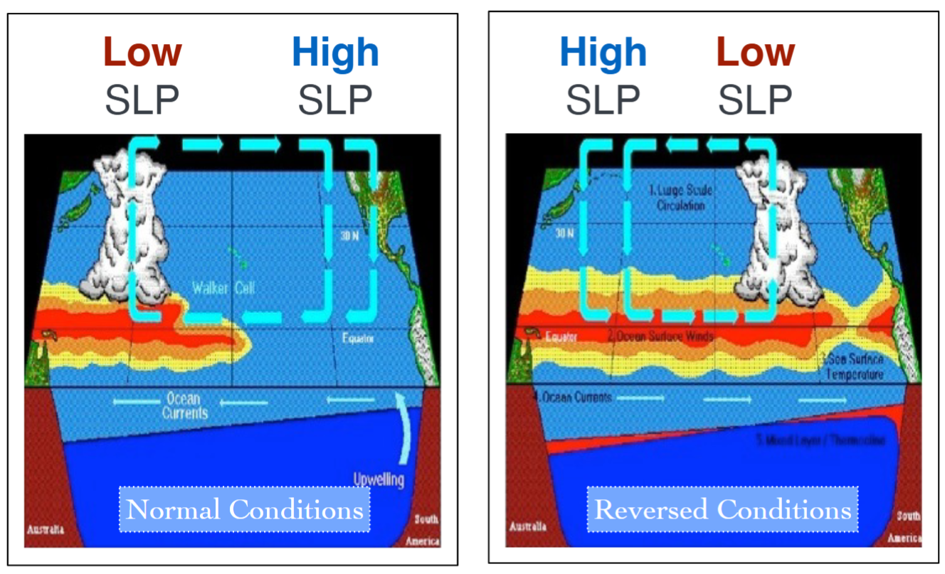
sea surface temperature (la nina)
exceptionally strong trade winds
equatorial upwelling and cooling in the eastern pacific
sea surface temperature under normal conditions
normal trade winds
upwelling and cooling in the eastern pacific
sea surface temperature (el nino)
exceptionally weak or reversed trade winds
little or no equatorial upwelling
strong warming in eastern pacific
warming during el nino
warms surface water off peru
also has a greater warming event, covering large parts of eastern tropical pacific and reaching down to the thermocline
what happens to the global average temperature when the thick warm pool of water in western pacific spreads out over a large area of the equatorial pacific during an el nino period?
it goes up as the area of warm water in contact with the atmosphere increases and the ocean gives up some of its stored heat to the atmosphere
direct impacts of el nino’s conditions on pacific precipitation and storm patterns
relative cooling in the western tropical pacific creates drought conditions in australia and indonesia during an el nino
relative warming in central and eastern tropical pacific heat energy for formation of intense precipitation and storms
seen in flooding of california/western US
el nino’s direct effect on biological productivity off of peru and ecuador
less biologically productive
what type of trend is human-caused global warming
a multi-decadal trend
other natural climate variations that can temporarily warm and cool the earth are superimposed on this multi-decadal trend
what is the current status of the el nino/lanina conditions
tropical pacific is now enso-neutral after a few months of la nina conditions
la nina conditions will emerge in the next couple of months and continue through the northern hemisphere winter
how has el nino affected coral reefs
bleaching of coral reefs
2015-2016 and 2023-2024 el nino events were disastrous for coral reefs
jet stream’s north/south position relative to el nino conditions
jet streams have wave-like properties
the regional disturbance in the jet stream position propagate around the globe in a wave-like fashion
enso produces such a disturbance in the jet stream that can propagate around the world