APES Unit 4
1/46
There's no tags or description
Looks like no tags are added yet.
Name | Mastery | Learn | Test | Matching | Spaced |
|---|
No study sessions yet.
47 Terms
earth’s structure
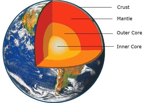
core: dense mass of nickel, iron, and radioactive elements that release massive amounts of heat
mantle: bulk of Earth’s interior; three layers
magma (molten rock): layer that slowly circulates due to heat from core
asthenosphere: thin, brittle layer of rock floating on top of mantle (broken up into tectonic plates)
lithosphere: thin, brittle layer of rock floating on top of mantle (broken up into tectonic plates)
crust: very outer layer of the lithosphere, Earth’s surface
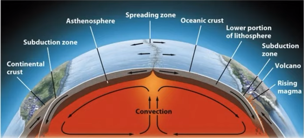
divergent plate boundary
plates move away from each other
rising magma plume from mantle forces plates apart
forms: mid-oceanic ridges, volcanoes, seafloor spreading, and rift valleys (on land)
convergent plate boundary
plates move towards each other
leads to subduction (one plate being forced another)
forms: mountains, island arcs, and volcanoes
transform fault plate boundary
plates slide sideways past each other (earthquakes)
forms: faults (fracture in rock)
mantle convection currents
magma heated by earth’s core rises towards lithosphere
rising magma forces oceanic plates apart
creates mid-ocean ridges, volcanoes, spreading zones, or “seafloor spreading”
magma cools and solidifies into new lithosphere at spreading zone
spreading magma forces oceanic plate under continental plate
sinking oceanic plate melts back into magma
new magma is forced up, creating narrow, coastal mountains (e.g Andes) and volcanoes on land

convergent boundaries
oceanic-oceanic: one plate subducts underneath other
forces magma up to lithosphere surface, forming mid ocean volcanoes
island arcs
off shore trench
oceanic-continental: dense oceanic plate subducts beneath continental plate and melts back into magma
forces magma up to lithosphere surface
coastal mountains (andes), volcanoes on land, trenches, tsunamis
contential- continental: surface crust from both plates “buckles” upward (mountains)
Ex: Himalayas
transform fault boundary
plates sliding sideways past each other; can create a fault (fracture in rock surface)
earthquakes occur when rough edges of plates get stuck on each other
pressure builds as plates keep sliding, but edges stay stuck
when stress overcomes the locked fault, plates suddenly release slide past each other and release energy that shakes the lithosphere
Tectonic map can predict..
ring of fire: pattern of volcanoes and earthquake zones all around pacific plate
offshore island arcs (Japan)
from convergent boundaries
transform faults: likely location of earthquakes
hotspots: areas of especially hot magma rising up to lithosphere
mid-ocean islands (Iceland, Hawaii)
Soil
mix of geologic (rock) and organic (living) components
sand, silt, clay
humus: main organic part of soil (broken down biomass like leaves, dead animals, waste, etc.)
nutrients: ammonium, phosphates, nitrates
water and air
living organisms
weathering
breakdown of rocks into smaller pieces
physical (wind, rain, freezing/ thawing of ice)
biological (roots of trees crack rocks)
chemical (acid rain, acids from moss/ lichen)
weathering of rocks=soil formation
broken into smaller and smaller pieces
carried away and deposited by erosion
erosion
transport of weathered rock fragments by wind and rain
carried to new location and deposited (deposition)
subduction
one plate being forced beneath another, leads to
mountains, island arcs, earthquakes, and volcanoes
convergent plate boundary
Roles of Soil
Breaks down organic material and recycles nutrients
home to decomposers that break down dead organic matter and return nutrients to the soil
medium for plant growth
anchors roots of plants and provides water, shelter, nutrients (N, P, K, Mg) for growth
habitat for a variety of organisms
provides habitat for organisms like earthworms fungi, bacteria, moles, etc
filters water
filters rainwater+ runoff by trapping pollutants in pore spaces +plant roots, clean water enters groundwater+aquifers
Soil Formation
TOP:
breakdown of organic matter adds humus to the soil
soil nutrient level, depth of soil
erosion deposits soil particles from other areas, adding to soil
BELOW:
weathering of parent material produces smaller, and smaller fragments that make up geological/ inorganic part of soil
sand, silt, clay
minerals
things that effect soil formation:
parent material: soil pH, nutrient content
topography: steep slope= too much erosion; more level ground=deposition
climate: higher temps=faster breakdown of organic matter; more precip.=more weathering, erosion+deposition
organisms: soil organisms like bacteria, fungi, worms breakdown organic matter
Soil Horizons
O-Horizon: layer of organic matter (plant roots, dead leaves, animal waste, etc) on top of soil
provides nutrients and limits H20 loss to evaporation
A-Horizon: aka topsoil; layer of humus (decomposed organic matter) and minerals from parent material
has the most biological activity (earthworms, soil microbes) breaking down organic matter to release nutrients
B-Horizon: aka subsoil; lighter layer below topsoil, mostly made of minerals with little to no organic matter
contains some nutrients
C-Horizon: least weathered soil that is closest to parent material, sometimes called bedrock
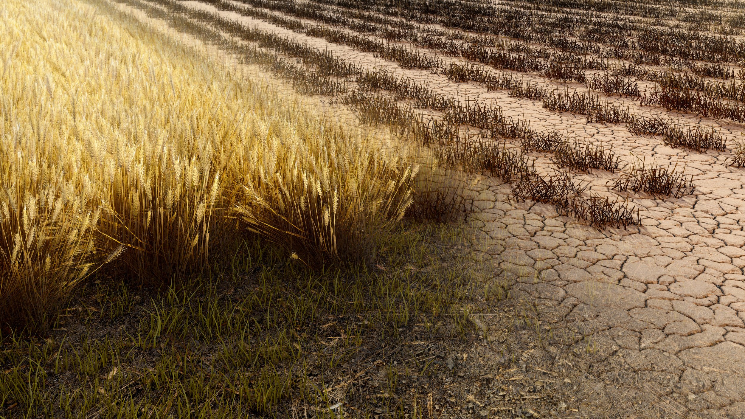
Soil Degradation
The loss of the ability of soil to support plant growth
loss of topsoil: tiling (turning soil for agriculture) and loss of vegetation disturb soil and make it more easily eroded by wind and rain
loss of topsoil dries out soil, removes nutrients +soil organisms that recycle nutrients
compaction: compression of soil by machines (tractors, bulldozers, etc.), grazing livestock, and humans reduces ability to hold moisture
dry soil erodes easier
dry soil supports less plant growth, less root structure, leading to more erosion
nutrient depletion: repeatedly growing crops on the same soil removes key nutrients (N, P, K, Na, Mg) over time
reduces ability to grow future crops
Soil texture
the % of sand, silt, and clay in a soil
always adds up to 100% ex: 40-40-20
since sand is bigger, it has bigger pores (empty spaces between particles)
allows air+water to enter sandy soil easily
clay has the smallest pores, so it’s harder for air + water to enter clay-heavy soils
porosity
the amount of pore space a soil has
more sand in soil=more porous/higher porosity (easier for water+air to enter)
more clay in a soil=less porous/ less porosity (harder for water+air to enter)
Porosity, Permeability, and H20 Holding Capacity
porosity: the pore space within a oil (more sand, more porous)
permeability: how easily water drains through a soil
more porous/ higher porosity=more permeability
h20 holding capacity: how well water is retained, or held by soil
more porous/ permeable=lower H20 holding capacity
soil that is too sandy drains water too quickly for roots and dries out, clay-heavy soil doesn’t let H20 drain and waterlogs roots. Ideal soil is loam which balances porosity with h20 capacity. (40-40-20)
Factors that increase and decrease soil nutrients
increase nutrients
N, P, K+,, MG2+, Ca+, Na+
organic matter (releases nutrients)
humus (holds and releases nutrients)
decomposer activity (recycles nutrients)
clay (negatively charge, binds with pos nutrients)
bases (calcium carbonate-limestone)
decrease nutrients
acids leach positively charged nutrients when excessive rain/ irrgation
excessive farming
topsoil erosion
factors that increase and decrease H20 holding cap
increase holding cap
aerated soil, biological activity
compost/humus/organic matter
clay content
root structure,native plants with deep roots
decrease holding cap
compacted soil (machines, cows)
topsoil erosion
sand
root loss
Gasses of Earth’s Atmosphere
Nitrogen-78%
in the form of N2 gas which is unusable to plants without being fixed
Oxygen-21%
produced by photosynthesis in plants and need for human and animal resp
Argon- 0.93% inert, noble gas
water vapor-0-4%
varies by region and conditions; acts as a temporary GHG but not that concerning
quickly cycles through atmosphere
CO2- 0.04%
most important GHG; leads to global warming
removed from atmosphere by photosynthesis
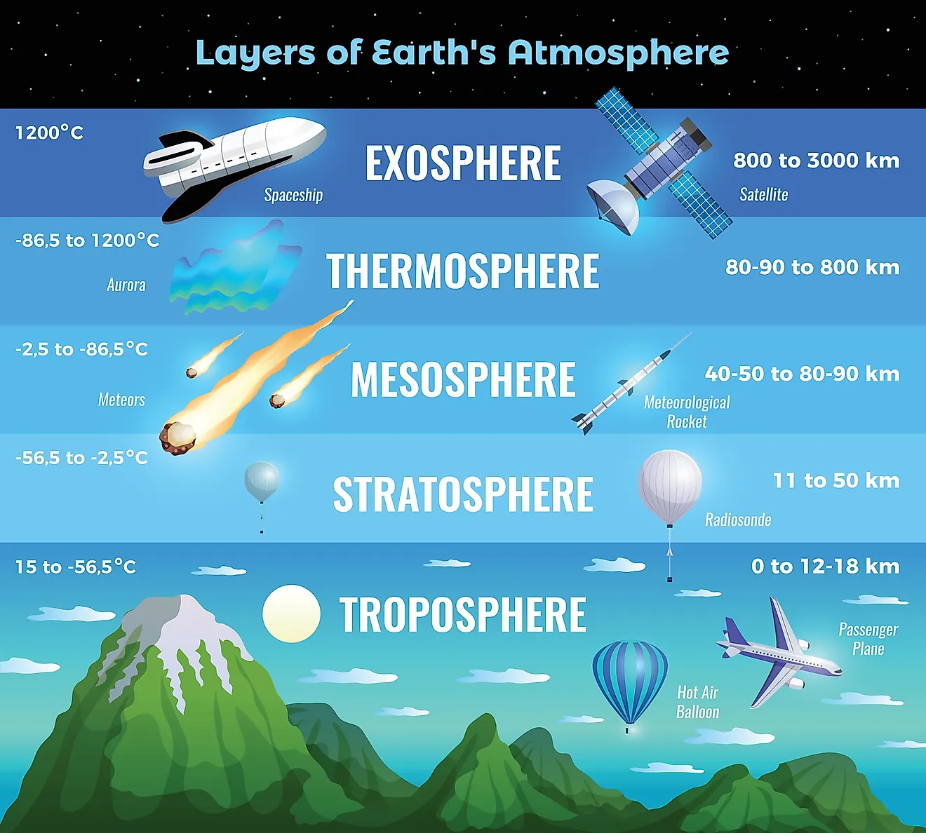
Characteristics of the Layers of the Atmosphere
exosphere: outermost layer where atmosphere merges with space
thermosphere: therm=hottest layer
absorbs harmful X-rays and UV radiation
charged gas molecules glow udner intense solar radiation producing northern lights (aurora borealis)
mesosphere: “m” for middle
even less dense
stratosphere: “s” for second
thickest O3 layer is found here; absorbs UV- B and C rays which can mutate DNA of animals (cancer)
trophosphere:
weather occurs here
most dense due to pressure of other layers above it
most of atmosphere’s gas molecules are found here
Ozone in the trophosphere is harmful to humans (resp irritant). damages plant stomata, and forms smog
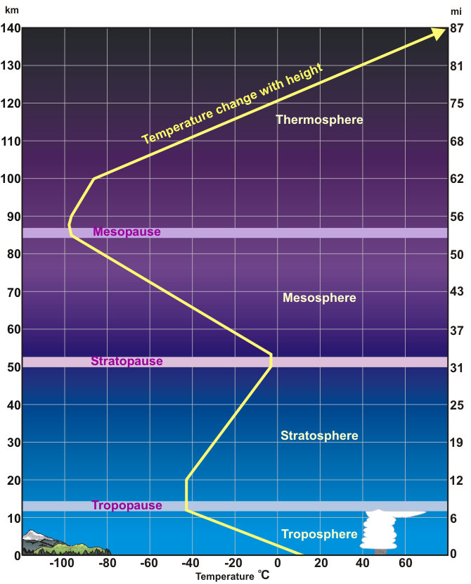
Temperature Gradient
layers of the atmosphere are based on where temperature gradients change with distance from earth’s surface
thermosphere: temperature increases due to absorption of highly energetic solar radiation
hottest place on earth
mesosphere: temperature decreases because density decreases, leaving fewer molecules to absorb sun
coldest place on earth
stratosphere: temperature increases because top layer is warmed by UV rays (like a top layer of a pool)
trophosphere: temperature decreases as air gets further from warmth of earth’s surface
Air Properties
warm air rises
warm air holds more moisture than cold
rising air expands and cools
cool air can’t hold as much H20 vapor
condenses→rain
after cooling and expanding, air sinks
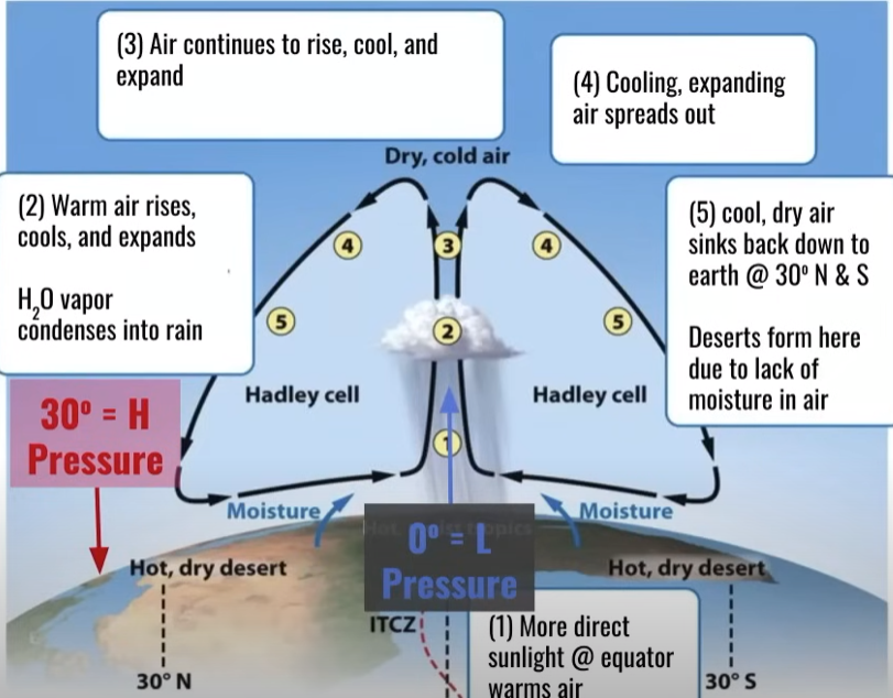
Hadley Cell
More direct sunlight at equator warms air
warm air rises, cools, and expands, H20 vapor condenses into rain
air continues to rise, cool, and expand
cooling, expanding air spreads out
cool, dry air sinks back down to earth @30degrees N and S
deserts form here due to lack of moisture in air
air moves from high to low pressure so air along earth’s surface flows from 30degrees back to the equator (0 degrees)
Coriolis Effect
deflection of objects traveling through atmosphere due to the spin of the earth
air at 30 degrees moves back to low pressure of equator
wind between 0-30 degrees moves from East to West
b/c earth is spinning west to east
winds between 30-60 degrees move west → east
bc earth spins faster at 30 than 60 degrees
Global wind patterns
Air moves out from 30 degrees to 0 degrees and 60 degrees due to high pressure at 30 degrees and low pressure at 0 and 60
air rising at equator=low pressure, air sinking down at 30 degrees= high pressure
0-30 degree winds blow east → west (eastern trade)
drives ocean current clockwise in Northern hemisphere and counterclockwise in Southern hemisphere
30-60 degree wins blow W→ East (westerlies)
drives weather patterns of North America

latitude
the measurement of distance north or south of the equator, expressed in degrees.
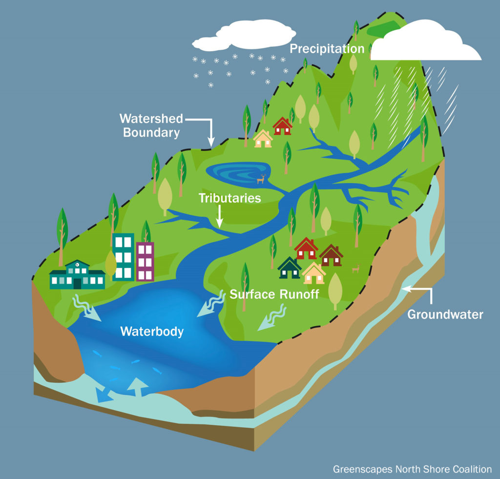
watersheds
all of the land that drains into a specific body of water (river, lake, bay, etc.)
determined by slope; ridges of land divide watersheds (diff. runoff directions)
vegetation, soil composition, and slope play a large role in how watersheds drain
more vegetation=mroe infiltration and groundwater recharge
greater slope=faster velocity of runoff and more soil erosion
soil permeability→ determines runoff vs. infiltration rates
human activities in a watershed impact water quality (agriculture, cleacutting, urbanization, dams, mining)
Chesapeake Bay Watershed
6 state region that drains into a series of streams/ rivers and eventually into Chesapeake Bay
mix of fresh and salt water + nutrients in sediment make estuary habitats like the salt marshes in the bay highly productive
provides many ecosystem services
tourism revenue—hotels, restaurants, permits
water filtration (grass roots trap pollutants)
habitats for food sources (fish and crabs)
storm protection (absorbing and buffering floods)
human impacts on Chesapeake Bay
Nutrient pollution (N and P) leads to eutrophication in the Bay
algae bloom due to increase of nutrients → decreased sunlight → plants below surface die → bacteria uses oxygen to decompose → hypoxia and dead zones (positive feedback loop)
Major N/P sources:
discharge from sewage treatment plants (in human waste)
animal waste from CAFOS
synthetic fertilizer from agricultural fields and lawns
other pollutants:
endocrine disruptors (from sewage treatment)
sediment pollution (deforestation, urbanization, tilling agricultural fields)
increases turbity (reduced photosynthesis) and covers over rocky streambed habitats
Solutions
cover crops: using plants in between the main crops being harvested to keep sediments and fertilizers from running into bodies of water
animal manure management: manure lagoons with better lining, draining more frequently, etc.
riparian buffers: areas alongside a body of water where you plant vegetation to add a sponge/ filter before water goes into bodies of water
septic tank upgrades: tank that collects waste→ optimize drain, prevent overflowing and contaminating nearby waters, biological waste removal
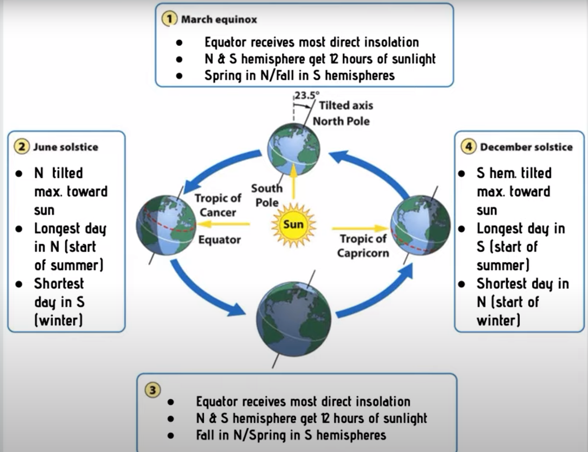
insolation
the amount of solar radiation (energy from sun’s rays) reaching an area
measured in Watts/ m²
solar intensity and latitude
solar intensity of insolation (W/m²) depends on:
a. angle: how directly rays strike earth’s surface
b. the amount of atmosphere sun’s rays pass through equator is more horizontal
equator=higher insolation than higher latitudes
higher latitudes=less insolation due to atmospheric distance needed to be breached and oblique angle (not right)
solar intensity and seasons
orbit of earth around the sun and tilt on axis changes angle of sun’s rays
this causes varying insolation, varying length of day, and seasons
tilt of earth’s axis stays fixed during orbit
June and December solstices: N or S hemisphere is maximally tileted toward sun (summer/winter) → longest day of year (June) shortest day (December)
March and September equinox: N and S hemispheres equally facing sun (spring and fall)
albedo
the proportion of light that is reflected by a surface
surfaces with higher albedo reflect more light, and absorb less (ice/snow)
absorb less heat
surfaces with low albedo reflect less light, and absorb more (water)
absorb more heat
urban heat island
urban areas are hotter than surrounding rural area due to low albedo of blacktop
climate and geography
climate is largely determined by insolation (latitude → angle of insolation and atmosphere)
higher latitudes receive less insolation: cooler, less precipitation (esp 30 degrees)
equator receives most intense insolation: higher temp, air rises, high precip
geography also plays a role
mountains: disrupt wind and produce rain shadow effect
oceans: moderate temperature and add moisture to the air
rain shadow effect
warm, moist air from the ocean hits the "windward” side of the mountain, rises, cools (condensing H20 vapor and causing rain) → lush, green vegetation
dry air descends down “leeward” side of mountain, warming as it sinks
leads to arid (dry) desert conditions
Global Ocean Surface Currents
gyers: large ocean circulation patterns due to global wind
clockwise in the northern hemisphere, counterclockwise in southern
east → west trade winds between 0-30 degrees push equator current E→ W
Westerlies between 30-60 push mid latitude currents W→E
upwelling zones
areas of ocean where winds blow warm surface water away from land mass and replace it with colder, deeper water
brings 02 and nutrients to surface → productive fishing
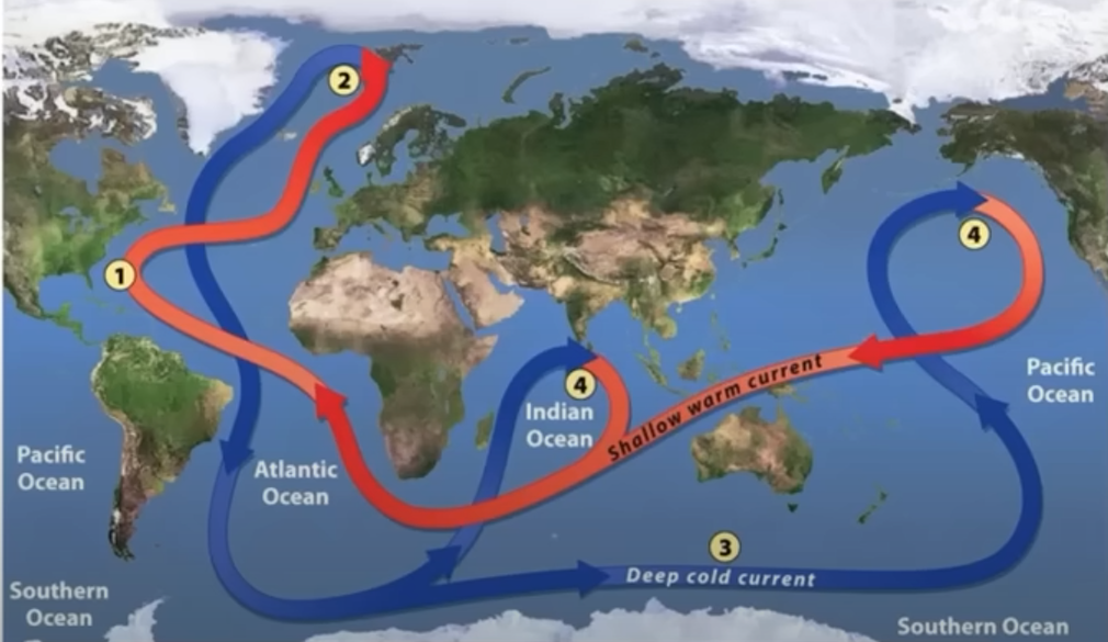
thermohaline circulation
connects all of the world’s oceans, mixing salt, nutrients, and temperature throughout
warm water from Gulfof Mexico moves towards North Pole
cools and evaporates as it moves towards poles
saltier and cooler water at poles, is more dense, making it sink
spreads along ocean floor
rises back up into shallow warm ocean current at upwelling zones
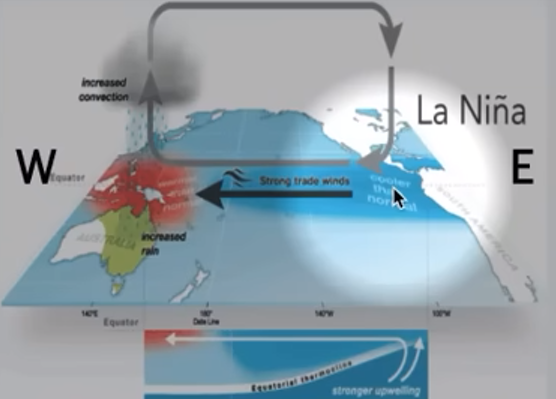
El Nino Southern Oscillation (ENSO)
pattern of shifting atmospheric pressure and ocean currents in the pacific ocean between South America and Australia/ Southeast Asia
oscillates, or shifts regularly from El nino (warmer, rannier) to La Nina (cooler, drier) conditions along coast of South America
El Nino Event
trade winds weaken, then reverse (W→E)
warm equator currents bring heat and precipitation to Americas (warmer winter)
increased precip and flooding in Americas (esp west coast)
suppressed upwelling off SA coast (damaging fisheries)
cooler, drier conditions in Australia and SE Asia (weakened monsoon activity)
High pressure in west pacific (Aust, SEA)
low pressure in east pacific (SA)
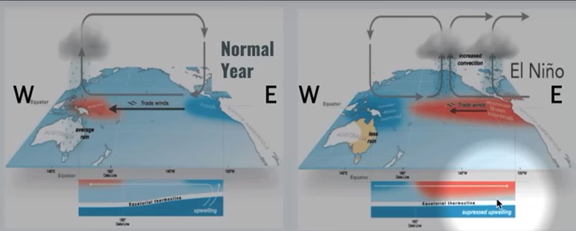
La Nina conditions
stronger than normal trade winds (W,←E)
increasing upwelling off SA coast brings cooler than normal conditions
better fisheries
worst tornado activity in the US and hurricane activity in the Atlantic
warmer and higher precip in Aust and SEAS