charts + chart scales
1/20
There's no tags or description
Looks like no tags are added yet.
Name | Mastery | Learn | Test | Matching | Spaced |
|---|
No study sessions yet.
21 Terms
VFR terminal charts (VTAs) provide detailed information to VFR pilots __________
operating in busy terminal areas
VFR navigation charts (VNC) provide navigation information to VFR pilots __________
during the enroute portion of a VFR flight
World aeronautical charts (WACs) are used for flight planning and in-flight navigation _______
on extended cross-country flights at low-to-medium altitudes and medium-to-high airspeed
Canada Air Pilot (CAP) provides aeronautical information primarily related to _________
IFR arrival or departure phases of flight
The CAP includes the following types of flight procedures:
Instrument approach procedures (IAPs)
Diverse and standard instrument departures (SIDs)
Standard instrument arrivals (STARs)
Noise abatement procedures
Visual approaches
Ground operations information
Which of these charts are updated every 56 days?
CAP, CFS, DAH, HI/LO charts, TAC (Terminal Area Charts)
Pilot navigation SIDs require pilots to _____ for navigation to ______
use the applicable SID chart as reference, enroute phase
Vector SIDS are when ATC provide ______, or _____ on the applicable SID chart.
vectors to a filed or assigned route, a fix depicted
While waiting for vectors, pilots are expected to ______.
use the SID chart as reference for navigation
Define Standard Terminal Arrival (STAR)
Help aircraft transition from the enroute phase of flight to landing at an airport
Enroute low altitude charts (LO charts) are intended for use up to, but not including, ________ within _________.
18,000 feet ASL, Canadian Domestic Airspace (CDA)
Enroute high altitude charts (HI charts) provide pilots with the navigational information required to navigate airspace over ________ at _________.
Canada and the Northern Atlantic, 18,000 feet ASL and above
What are the two types of standard instrument departures (SIDs)?
Pilot navigation and vector
What kind of chart provides navigation information for IFR flights in low-level airspace?
Enroute low altitude (LO) chart
VFR aeronautical information can be obtained from what three key sources?
VTA charts, VNC charts, WAC charts
A pilot flying at FL240 over Kamloops needs to consult a chart for radio frequency information. What chart should the pilot consult?
Enroute high altitude (HI) chart
What would the map scale 1/500,000 represent?
Every 1 unit of measurement on the chart equivalent to 500,000 of the same unit of measurement on the ground
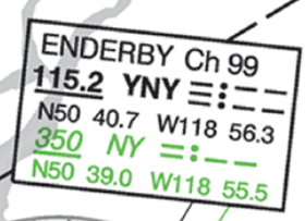
What is the frequency of the Enderby VORTAC?
115.2 MHz
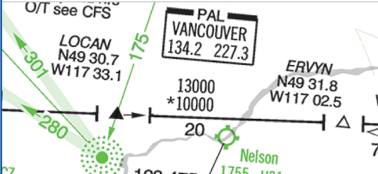
What is the minimum enroute IFR altitude between LOCAN and ERVYN on V300?
13,000 feet
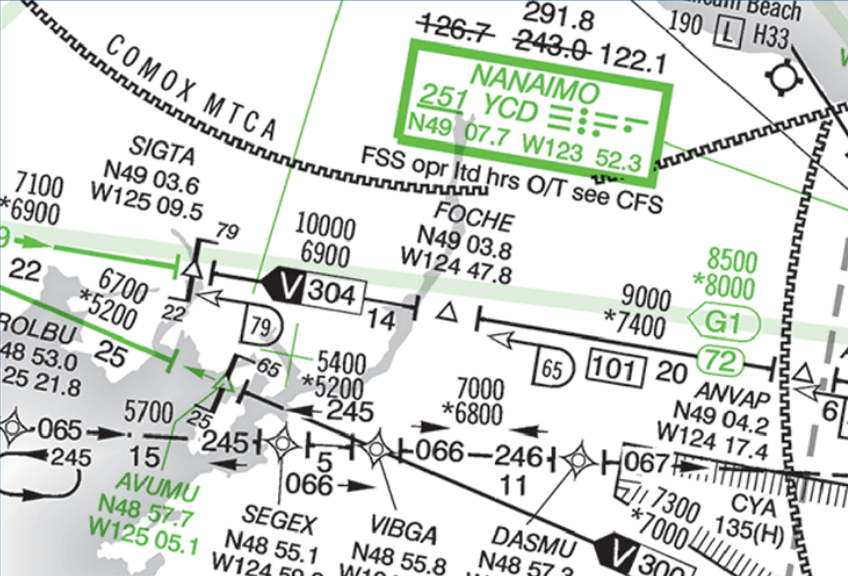
What is the minimum enroute altitude on V304 between FOCHE and SIGTA?
10,000 feet
What information do LO charts include?
Airways and route data, minimum altitudes, radio aids and frequencies, reporting points, etc.