Jet Streams
1/12
There's no tags or description
Looks like no tags are added yet.
Name | Mastery | Learn | Test | Matching | Spaced | Call with Kai |
|---|
No analytics yet
Send a link to your students to track their progress
13 Terms
Definition
● This is a relatively horizontal, high speed, and tubular shaped current of air in the vicinity of the tropopause.
● Its axis is centered on a line of maximum wind speeds, and it is characterized by high wind speeds and strong wind shears
Characteristics
● A Jet Stream's length is normally several thousand miles, and they can often be continuous around the hemisphere!
➢ Width is a few hundred miles.
➢ Depth is typically 2 to 6 miles.
➢ Altitude range usually 10 000 to 30 000 feet. winter lower
➢ A ragged windswept appearance of the cirrus clouds is always an indication of very strong winds or jet streams
● Wind speeds of at least 60 KT are found at every point along its axis and these may increase in a few places to more than 200 knots.
● These wind speeds will drop abruptly above, below, and to either side of the jet core.
● These winds are located in the warm air side of a front and about 2 000 to 3 000 feet below the warm air boundary in the tropopause
Jet Stream Development
● The upper winds are primarily controlled by the temperature structure of the atmosphere below them.
● Frequently, there is a strong horizontal temperature gradient that will exist through a deep layer of the atmosphere.
● When this occurs, jet streams develop.
● The major jet streams in the northern hemisphere are located just below the tropopause
● at each frontal system there is a sharp temperature contrast which produces an abrupt change in tropopause height
● This abrupt change in tropopause height causes a tear between the heights of the pressure surfaces in the upper tropopause.
● These in turn cause the jet stream development
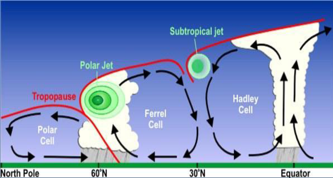
Polar Front Jet Stream
● The Polar Jet Stream is the most important jet stream found in the northern Hemisphere.
● It is a frontal type of jet stream and can enhance and/or change the surface weather patterns
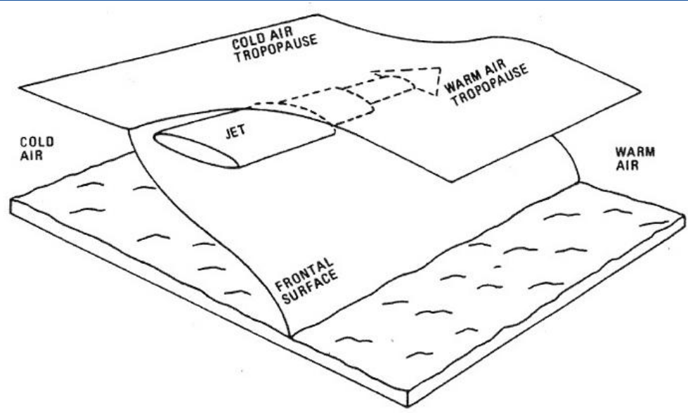
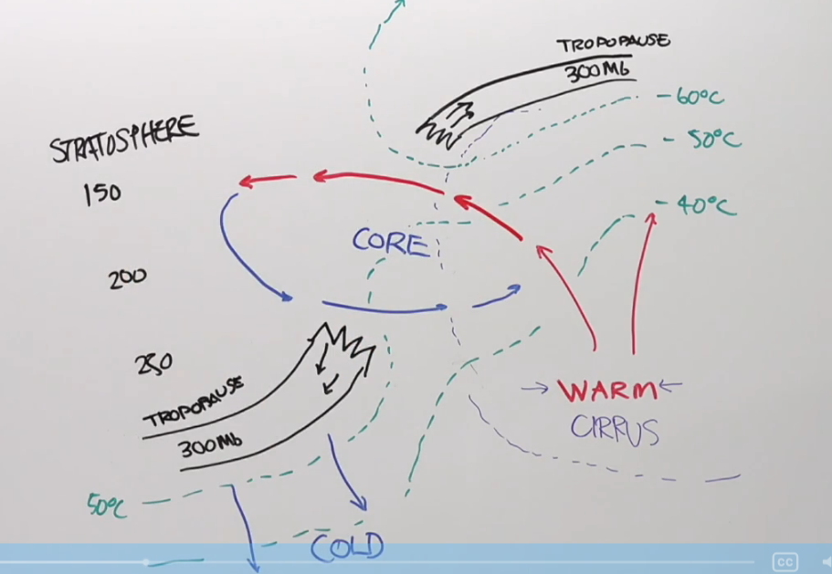
Position of the Jet Core
● This diagram shows the position of the jet core in relation to the frontal surface, the warm air tropopause and the cold air tropopause
● Looking downwind, towards the east, the warm air tropopause lies to the right and above the core whereas the cold air tropopause to the left and about the same level or a little lower than the core.
● The jet is always associated with a cold front, except for the special case of the subtropical jet.
● The position of the jet will lie in the warm air above and to the north of the frontal surface
Seasonal Height and Speed Variations
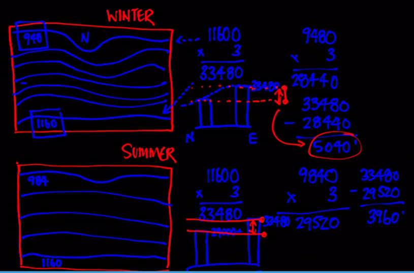
● Jet streams tend to move south in terms of latitude in the winter and they will do this along with their associated fronts.
➢ This makes sense since the cold air will migrate southwards during the cold weather.
● Jet core speeds tend to be higher in the winter than in summer.
➢ This is because the temperature contrasts across air masses and their corresponding fronts are often sharper in winter.
● The altitude of jet cores are also lower in the winter due to the lowered pressure heights.
➢ Colder air is more dense = lower heights for a given pressure value.
Forget the numbers. Each countour is tropopause height from south NA to north. Winter has a bigger difference between south and north, meaning more temperature gradient = more and faster winds
Jet Stream Turbulence
● The temperature of the lower stratosphere approximates that of the tropopause.
➢ The tropopause is higher and colder over a warm air mass.
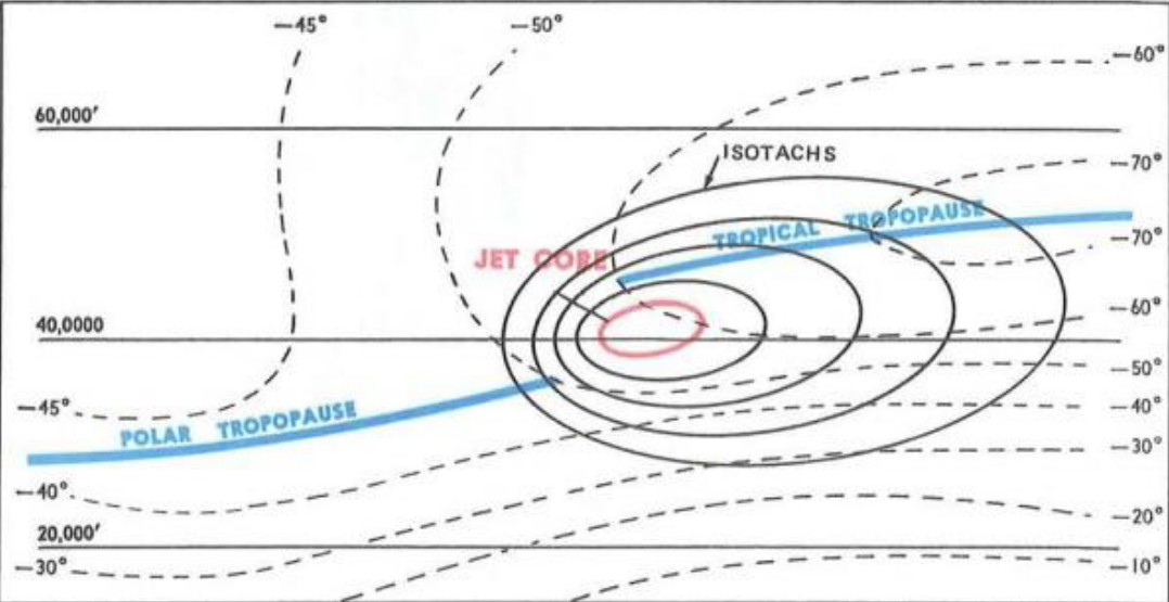
● If the 30 knot isotachs are spaced closer together than 90 NM on the 250 mb chart, you can expect enough horizontal shear to be occurring to create significant amounts of CAT.
● Jet stream vertical shear varies from 5 knots per 1 000 feet up to 20 knots per 1 000 feet.
● Not all jet streams have turbulence.
● Turbulence is frequent on the cold air side, due to the sudden drop in wind speed.
● Turbulence also is more common above the core, between the core and the tropopause.
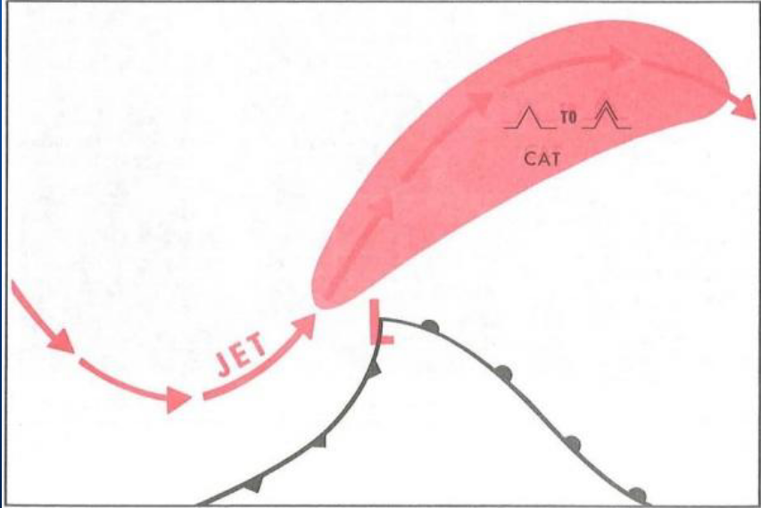
● CAT is most likely to occur in an upper trough on the poleward side of the jet stream
● The most severe Clear Air Turbulence is usually found on the poleward (low pressure) side of the jet stream axis due to cold
● When jet stream turbulence is encountered while flying with a tailwind, turn to the right in the Northern Hemisphere to get away from the turbulent area
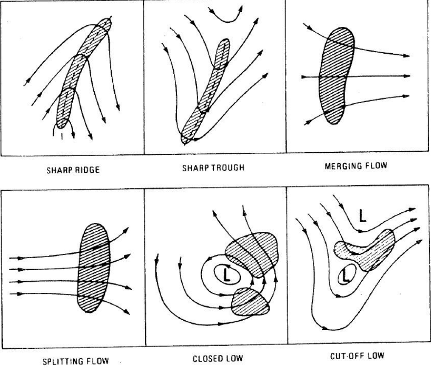
● Common locations of jet Stream Turbulence relative to the isotach positions are shown here (tight turns, splitting, joining)
Jet Stream Vertical Turbulence
● When jet stream turbulence is encountered while flying with a crosswind, typically from north to south or south to north, observe the OAT gauge for a minute or two and
➢ if the temperature rises, climb to get out of turbulence;
➢ if the temperature falls, descend to get out of turbulence;
➢ if the temperature remains constant, either climb or descend as convenient to get out of turbulence.
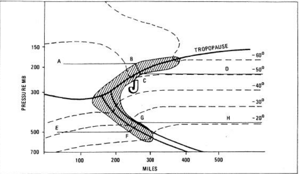
Avoiding Turbulence by Using Temperature Gradients
● Example: While travelling from A to D and at B you notice temperature is falling, you would descend to find smoother air.
● While travelling from E to H, which action should be contemplated at F? Climb
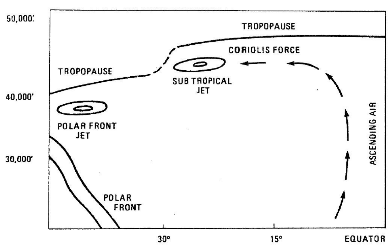
Subtropical Jet Stream
● Another common jet stream in North America that is not associated with frontal systems is the Subtropical Jet Stream.
● Remember that very strong solar heating in the equatorial regions produces a belt of ascending air.
● This air then turns poleward at the high levels, and the Coriolis force then turns these winds to the right, causing a jet that will flow from the west to the east
● If the location of the polar front moves exceptionally far south, the polar front jet stream may merge with the subtropical jet stream.
● Once again, it is important to note that a Jet Stream that is found near to the poles will be found at lower heights.
➢ This is because the cold air is denser and thus the tropopause level is lower
Low Level Nocturnal Jet
● Overnight cooling creates a temperature inversion a few hundred feet above the ground that can produce significant wind shear.
● As the nocturnal inversion develops, the wind shear near the top of the inversion increases.
● Near midnight it typically reaches top speed.
● Maximum wind varies from about 700 to 2 000 feet AGL
● Winds speeds vary from up to 8 KT at ground level to 25 to 40 KT at the jet maximum, dropping to 15 to 30 KT 1 000 feet or so above the maximum wind.
➢ In extreme cases maximum speed in excess of 65 knots with wind shears of 10 KT per 100 feet below it
Low Level Nocturnal Jet Stream
● As daytime heating increases the inversion is dissipated.
● This phenomenon is known as the Low Level Nocturnal Jet.
● The low level jet stream is a sheet of strong winds thousands of miles long and hundreds of feet thick that forms over flat terrain in the prairies
Low Level Jet Stream CAT
● Wind speeds of 40 KT or greater are common.
● Of course, such a sudden change in wind speeds can pose the pilot with a hazardous amount of low-level wind shear.
● In the morning, as the inversion dissipates, the shear plane and gusty winds will move closer to the ground.
➢ This will cause wind shifts and increases in wind speed near the surface