Urban enviroments
1/19
Earn XP
Description and Tags
human factors
Name | Mastery | Learn | Test | Matching | Spaced |
|---|
No study sessions yet.
20 Terms
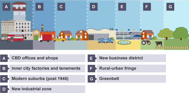
land use zones in developed world cities
Different areas within towns and cities can be recognised according to their land use. Land uses such as housing and industry can be grouped together into land use zones:
Central business district (CBD)
Inner city (old housing and old industrial zones)
New housing zone
New industrial zone
New business district
The diagram below highlights these different land use zones in a town/city.
Location of central business district
Glasgow
Locations of the CBD
In the centre of a city.
At the most accessible location such as at a crossing point of a river, like Glasgow's River Clyde.
Near the oldest part of town.
Reasons for CBD location
Central location for road/railways to converge.
Most accessible location for workers.
accessible to most people for shops and businesses
Often a strong geographical location, eg Glasgow is surrounded by hills for defence.
Location of central business district
Identifying features of the CBD
Tall/multi-storey buildings
Expensive land values
High density of roads and buildings
Lack of open space
Shops, eg department stores
Modern shopping malls and pedestrian precincts
Cultural/historical buildings,eg museums and castles
Offices, eg business sector
Entertainments, eg theatres and clubs
Bus and railway stations
High traffic and pedestrian flows, eg commuter rush-hour
Multi-storey car parks
Grid iron street pattern
Examples in Glasgow
High/multi-storey buildings - Hilton Hotel
Modern shopping mall/pedestrian precinct - Buchanan Galleries
Lack of open space - Merchant City
Department stores
Cultural/historical buildings - Gallery of Modern Art
Entertainment
Transport centres - Buchanan Street Bus Station
Multi-storey car parks
Grid iron street pattern - Sauchiehall Street, Bath Street and Renfield Street
Location of inner city
Glasgow
Locations of the inner city
In older cities, the inner city area is near the centre and surrounding the CBD.
Inner city areas are identified not only by their physical features but often by negative socio-economic features, eg derelict buildings, waste ground and run-down housing.
Reasons for inner city location
Old heavy industrial factories were near the city centre.
Low-cost housing like tenements were built quickly for poorly paid workers who needed to live close to work.
People in poor inner city areas were able to make use of city centre amenities.
locations of inner city
Identifying features of the inner city
High density of buildings and lack of good quality open space, eg parks.
Grid iron street pattern
Older, 19th century, low-cost housing - likely to be tenements in Scotland and terraced housing in England.
Poor quality housing with a lack of gardens.
Derelict land
Old industry in decline or shut down.
A declining population with high unemployment.
Large areas of redevelopment or urban regeneration.
Limited convenience shopping facilities.
High levels of air pollution from traffic.
Visual pollution in the form of vandalism and graffiti.
Areas demolished and used for motorways and ring roads.
An example of an inner city area in Glasgow is Govan.
new housing zone
Glasgow
Location of a new housing zone
On the outskirts of the town/city in the suburbs.
Where there is more space to build.
Beside main transport routes for access into CBD.
Reasons for new housing zone location
Towns and cities grow outwards, so logically the newest houses will be further away from the oldest part of the town in the CBD.
There is more space and cheaper land to build larger family homes with gardens and garages.
new housing zone
Identifying features of a new housing zone
Low density and larger houses as the land is cheaper away from the CBD.
Street pattern designed by town planners in modern cul-de-sacs and crescents to reduce the speed of traffic and so safer for children.
Good quality open space, eg parks.
Newer, 20th and 21st century housing - likely to be detached or semi-detached houses.
Good quality housing with gardens and space for extensions like conservatories.
Surrounded by green land.
Separated from industry.
Convenience shopping facilities, eg corner shops.
Nearby schools for children.
Low levels of air pollution as far away from CBD traffic.
Quieter area with nicer scenery because of its proximity to the countryside.
An example of a new housing area in Glasgow is Newton Mearns.
new industrial zone
Glasgow
Location of a new industrial zone
On the outskirts of the town on a greenfield site.
Beside main roads for access.
On flat land with open space.
Reasons for new industrial zone location
It is away from the congestion of the CBD.
There is room to expand.
The land is cheaper so low density factories can be built.
new industrial zone
Identifying features of a new industrial zone
Low density – one or two storey buildings.
Modern buildings built of brick and finished with glass.
Separated from housing.
Landscaped with trees and shrubs.
Factories are grouped together in industrial estates.
Main roads are nearby to import/export.
Large car parks for workers and delivery lorries.
An example of a modern industrial estate in Glasgow is Hillington Industrial Estate.
new business district
Glasgow
Location of a new business district
On spacious sites on the outskirts of a town/city.
Beside main roads/motorways.
Reasons for new business district location
There is plenty of space to build large supermarkets, furniture stores and entertainment facilities like bowling alleys and cinemas.
Motorways provide easy access for shoppers.
new business district
Identifying features of a new business district
Very large buildings, eg cinemas and supermarkets.
Shops and services grouped together in retail parks.
Separated from housing and industry.
Thousands of free parking spaces.
Beside motorway or where main roads meet.
Built on cheap land with space to expand.
Low modern buildings.
Wide roads to accommodate many cars and delivery trucks.
An example of a new business district in Glasgow is Braehead.
CBD developments in Glasgow
Shopping changes
Change | Positive impact | Negative impact |
Out-of-town shopping centres like Braehead and Silverburn have been built with plenty of free car parking | Indoor malls make shopping more enjoyable instead of bearing the cold and rain in the city centre | Competition with city centre retailers has meant that some shops in town have closed down |
New retail parks and trading estates, eg Strathkelvin Retail Park on the edge of town | Shoppers can take home big and bulky goods in their car | Some smaller companies have closed down as they can't compete |
Pedestrianised shopping streets, eg Argyle Street and Buchanan Street | Safer and less polluted shopping environment | Cars are restricted to other areas and congest neighbouring streets |
New supermarkets open 24 hours in out-of-town locations | Allow shoppers to buy everything they need and include services like opticians and dry cleaning services | Smaller shops can't compete, eg butchers and fishmongers are forced to close down |
CBD developments in Glasgow
Transport changes
Change | Positive impact | Negative impact |
Improved public transport, eg bus lanes help to keep buses running on time | Fewer people take their cars into the city centre so less congestion | Travellers are inconvenienced if services are cancelled, eg because of bad weather |
One-way streets, eg Hope Street | Allow traffic to flow freely and move faster | Difficult for drivers to get around the city centre if they are unfamiliar with the restrictions |
Park and Ride schemes, eg Cumbernauld. | Fewer cars in city centre so less congestion | Train fares are becoming more expensive |
Reduced on-street parking with multi-storey car parks, parking charges, double yellow lines and traffic wardens | Fewer cars illegally parked on streets blocking them | Expensive to park car – some car parks charge per 15 minutes |
Ring roads that avoid the city centre | M8 motorway allows through traffic to avoid CBD congestion | Roads are still congested at peak times. |
recent developments on rural/urban fringe
Housing developments
From the 1960's onwards, new towns, eg East Kilbride, and council estates like Castlemilk, were built on greenfield sites on the outskirts of the city to combat overcrowding in the inner city sub standard housing.
New housing developments continue to add to the problem of urban sprawl today. Small villages like Clarkston have now been swallowed up by the Glasgow city boundary and farming villages like Eaglesham have been turned into commuter settlements.
New industry and new business districts
Industrial estates, retail parks, large supermarkets and shopping centres are located on the edge of the city to take advantage of the cheaper land, room for expansion, access links and nearby population for labour and market. Silverburn is a recent example of a shopping centre built on the greenbelt of Glasgow.
However, these developments increase urban sprawl and put pressure on the greenbelt. The impact of these developments is a decrease in farmland and a loss of wildlife habitats.
recent developments on rural/urban fringe
Decentralisation of offices
Some offices are relocating to business parks on the outskirts of the city beside main roads for access. They are moving to take advantage of the cheaper land with room to expand, and the unpolluted environment in the countryside helps to attract a highly skilled workforce. However, this relocation contributes to urban sprawl and land use conflicts with rural land users, eg farmers.
Transport changes
Many main roads, motorways and train lines link the suburbs with the city centre to allow commuters easy access to work, shopping and entertainments. Park and ride schemes have been particularly important to enable people to travel to events without taking their cars, eg football matches and arena concerts.
issues in informal settlements in developing cities
Many people in developing countries have given up subsistence farming in the countryside and made their way to large cities like Rio de Janeiro.
They move in search of a better life. People are attracted to cities in the hope of finding well-paid jobs in factories, better schools for their children, entertainment, better health care and a higher standard of living.
Unfortunately, the reality is very different as many families find themselves struggling for survival in sub-standard housing in Brazil.
Rio de janerio
The huge volume of people migrating to cities has caused many problems.
New arrivals to the city build their own houses out of basic materials such as tarpaulin, corrugated sheets and broken bricks, on land which they neither own nor rent.
These areas are illegal and are not catered for by the Government, so there is no electricity, rubbish collection, schools or hospitals. The houses in these settlements have no basic amenities such as running water or toilets, so there are high incidences of diseases like cholera and dysentery.
Overcrowding is a major problem in Rio's informal settlements. On average, the population density is about 37,000 people per square kilometre. Because of the lack of toilets and poor sanitation, sewage often runs in open drains. This causes diseases which spread rapidly.
People are poor and cannot afford healthcare or medicines so illnesses go untreated. Diseases spread rapidly. As a result, infant mortality rates are high and life expectancy is low (on average 56 years) in Rio's informal settlements.
There are not enough jobs to go around, so unemployment rates are high. Most people who do have a job work in the informal sector for 'cash in hand', eg labourers, selling food on street stalls or cleaners. Informal sector jobs are very poorly paid and the work is irregular so a steady income is not guaranteed.
The crime rate in informal settlements is extremely high as they are controlled by gangs who are involved in organised crime. Rocinha is so feared by police that they do not patrol on foot without guns.
Rio is hemmed in by mountains, so during tropical storms and landslides are common. Make-shift houses in informal settlements offer little protection to people and houses are easily washed away by the heavy rain and mud.
solutions
Self-help schemes
These are small scale projects which allow local people to use their skills to help improve their local area. The Government has provided materials such as bricks, cement and glass to enable residents to improve their own homes. This often fosters a community spirit as many families work together to make the improvements.
In Rocinha, self-help schemes have improved the area from sub-standard housing to low quality housing where the majority of homes have basic services like electricity. There are now also many services in Rocinha including cafes and shops. Some people have been granted legal ownership of the land on which their houses are built.
Site and service schemes
These are projects undertaken by the local authority to relocate residents from informal settlements. Brick houses are built with electricity, running water and sanitation pipes installed.
People may be allowed to buy these houses. An example of such a scheme is 'The Favela Bairro Project'. Services in these areas also include refuse collection, schools and health centres.
Charities
Charities help to improve life for people in informal settlements by providing money for self-help schemes. The Developing Minds Foundation builds schools and supports education programmes in Rio's informal settlements. Their aim is to improve the literacy rates of children so they can get a good job, improve their standard of living and have more life choices.