GEOHAZARDS 2 (copy)
 Call Kai
 Learn
Learn Practice Test
 Spaced Repetition
 Match
Match Flashcards
 Knowt Play
1/85

There's no tags or description
Looks like no tags are added yet.
Name | Mastery | Learn | Test | Matching | Spaced | Call with Kai | Chat |
|---|
No analytics yet
Send a link to your students to track their progress
86 Terms
LANDSLIDES
general term for rapid downslope movements/failure, with potential to kill people along their path
Mass Wasting
Is even more general and includes slow movements (creep, slow flows)
Mass wasting / slope failure / landslides
all downslope movement of rock and sediment that occurs at the surface of the earth (also underwater) in response to gravity. Speeds range from extremely fast to extremely slow.
Gravity
Main driving mechanism of mass wasting/land slides
Basis for Classification of Landslides
Based on the type of materials involved, speed, and type or mechanism of downslope movement
Range Speeds of Landslides
Extremely fast to Extremely slow
Types of Downslope Movements
Fall
Topple
Flow
Slide
Subsidence
Flowage
Downslope movement type when soil and water involved
Sliding
Downslope movement type when material slides along a slip plane. Occurs when there is a distinct zone of weekness between the slide material and the more stable underlying material.
Types of material involved in Landslides
ROCK, SOIL (Earth materials 80%>2mm (coarser), Debris 2mm<20% )
ROCK
a hard or firm mass that was intact and in its natural place before the initiation of movement.
SOIL
an aggregate of minerals and rocks that either was transported or was formed by the weathering of rock in place.
Fall
Rock material falling vertically. Common in rugged terrains where slopes are oversteepened by erosion, water, or road cuts.
detachment of material from a steep slope along a surface with little or no shear displacement, the material descend mainly by falling, bouncing, or rolling
Topple
Toppling of material. Forward rotation and movement of rocks/ice/regolith out of a slope at a point or an axis. Common where there is a pronounced vertical or steeply dipping discontinuity in a rock formation.
forward rotation out of the slope of materials about a point or axis below the center of gravity of the displaced mass
Slide
movement occur dominantly on surfaces of rupture or on relatively thin zones of intense shear strain
Rotational Slide or Slumping
Type of sliding with a curved slip surface
Translational slide
Type of sliding with planar slip surface with little rotation or back tilting
Spread
Landslides that commonly form on gentle slopes or flat slopes that have rapid, fluid-like flow movements similar to water. Common in loose sediments consisting of sand, clay, and silt.
extension of a cohesive soil or rock mass combined with a general subsidence of the fractured mass of cohesive material into softer underlying material; surface of rupture is not a surface of intense shear; may result from
Flow
Can be wet or dry. Mobilized soil materials due to rain. Or lahar flows/ mudflows when volcanic material is mobilized
spatially continuous movement in which surfaces of shear are short-lived, closely spaced, and usually not preserved; distribution of velocities in the displacing mass is like a viscous liquid
Creep
Very slow, nearly inpercebtible movements on gentle slopes.
slowest kind of landslide. definite steady movement of soil under the direction of low shear stresses
Complex
Landslides characterized by a mixture of types
combination of several mechanisms
Angle of repose
Maximum slope angle at which the material is stable. More cohesion means greater angle of repose
Driving forces of landslide
mass, gravity, pore pressure. Induces downward movement
Resisting forces of landslide
inertia, friction, cohesion. Tends to keep materials intact along a slope
mass, gravity, pore pressure
Driving forces of landslide
inertia, friction, cohesion
Resisting forces of landslide
Capillary Force
Cohesive force holding partices together in pore space mostly occupied by air. Allowing greater angle of repose.
Pore Pressure
Force exerted by large amount of water occupying all pore spaces. Keeps particles apart and reduces cohesion
Water, aside from exerting capillary force in small amounts or pore pressure in large amounts, adds mass to wet materials. This increases the gravitational pull on the slope which favors mass movement
Water, aside from exerting capillary force in small amounts or pore pressure in large amounts, adds mass to wet materials. This increases the gravitational pull on the slope which favors mass movement
Effect of slope angle
Inclination increases tendency of particles to move along a slope due to gravity instead of remaining still due to resisting forces
Factor of Safety (F.S.)
Determines slope stability
Formula for Factor of safety
ratio of resisting force and driving force
FS = Resisting Force/Driving Force
Resisting Force (RF)
Laboratory measure of rock strength and cohesion
Driving Force (DF)
Trigonometrically calculated force (mostly from gravity) due to angle of slope
If F.S.>1, then RF>DF and the slope is stable
If F.S.>1, then RF>DF and the slope is stable
1.5 or greater
Most modern building codes require a Factor of Safety of ___
3.5 or higher
Required Factor of Safety for major infrastructures like dams
Water, Earthquakes
Triggers of Landslides
Submarine Landslides in Hawaii
Largest and most far-reaching landslides on Earth
Geol 1 Nat Haz Mass Wasting Part 2
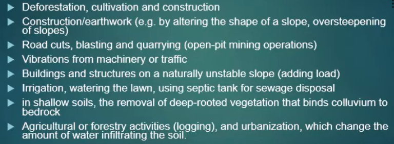
Human activities that increase the frequency of landslides
Slope over-steepening
(Slope-leveling for building and additional weight of building on lower part of slope can lead to slope failure)
(Human impact on mass wasting) to produce more level surfaces is one mechanism which can lead to slope instability and mass wasting.
Addition of water
(Human impact on mass wasting) through irrigation, septic systems, artificial ponds or leaky in-ground pools, etc., loosens up slope material and adds weight, promoting slope failure
Devegetation
(Human impact on mass wasting) concentrates surface runoff and enhances erosion, resulting in steeper slopes. Reduced interception and evaporation increases amount of water in ground. (Also, construction of logging roads result in oversteepening.)
Scars; barren or lack of vegetation
Disrupted topography
Historical records of past avalanche
Records of the character of past volcanic activity – debris avalanche
Tilted vegetation (in creep)
cracks in driveways, garage floors, freestanding brick or concrete walls, or buildings; cracks in walls or ceilings
Recognizing past mass movements/landslides
1. Identify potential hazard
- Map unstable areas; consult a geologist
- Avoid landslide-prone areas; zoning
Slope reduction and revegetation
Use of retention structures
- vertical piles on the toe of landslides
- buttress such as gabions or retaining walls
- rock bolts to stabilize rocky slopesRemoving fluid
Chemical treatment
What can be done to prevent (or correct) landslides?
Landslide Hazard Map
indicates the possibility of landslides throughout a given area
it may be as simple as a map that uses the locations of old landslides to indicate potential instability, or as complex as a quantitative map incorporating probabilities based on variables such as rainfall thresholds, slope angle, soil type, and levels of earthquake shaking.
an ideal landslide hazard map shows not only the chances that a landslide may form at a particular place, but also the chance that it may travel downslope at a given distance.
an ideal landslide hazard map shows not only the chances that a landslide may form at a particular place, but also the chance that it may travel downslope at a given distance.
Landslide Inventory Map (Landslide Hazard Maps)
Show the location of past landslides
Landslide Susceptibility map
Describes the relative likelihood of future landslide based on intrinsic properties of a locality.
Prior failure, Rock or Soil Strength, Steepness of Slope
(Lanslide Hazard Maps) Three important site factors for Landslide Susceptibility
Landslide Risk Map
Show landslide potential and expected loses to life and property should a landslide occur. Combines landslide hazard map with
Mitigation Measures
Slope stabilization: keeping the water out
Slope stabilization: revegetation (Geotextiles (synthetic soil cover) are used to stabilize slope along with revegetation)
Slope Stabilization: retaining structures (Wire mesh, Geogrids, Wire Baskets)
Slope stabilization: ground anchoring, rock bolts (tonitrus bolts heh :])
Shelters (sheds are used to divert slides from the road (and people on it))
Slope stabilization: keeping the water out
Slope stabilization: revegetation (Geotextiles (synthetic soil cover) are used to stabilize slope along with revegetation)
Slope Stabilization: retaining structures (Wire mesh, Geogrids, Wire Baskets)
Slope stabilization: ground anchoring, rock bolts (tonitrus bolts heh :])
Shelters (sheds are used to divert slides from the road (and people on it))
Mitigation Measures
Vertiver Grass
Perenial Clump grass usually used for soil and water conservation.
Watershed
An area of land where all of the water that falls in it and drains off of it goes to a common outlet. Can be as small as a footprint or large enough to encompass all the land that drains water into rivers that drain into Chesapeake Bay, where it enters the Atlantic Ocean.
Floodplain
Area adjacent to rivers developed due to the frequent overbanking of water, experiencing frequent floods
Coastal Flooding, River Flooding
Two Types of Flooding
Excessive rainfall
Limited river channel capacity (Width, Depth, Gradient)
Dam failure
Causes of River Flooding
Runoff
water from rainfall that remains on the surface of the Earth and eventually flows into streams
Runoff = Precipitation - Infiltration - Interception - Evaporation
Runoff = Precipitation - Infiltration - Interception - Evaporation
Natural Levees
build-up along the river bank due to deposition of suspended sediment during floods
with each flood the levee is built higher and discharge must be higher for the next flood to occur
Floodplains
alluvial surface adjacent to a channel that is frequently flooded
Riverine flooding
Overtopping river banks
More concrete means less infiltration and less/no trees for evapotranspiration. Rainwater mostly becomes runoff
Why urbanization and flooding go together?
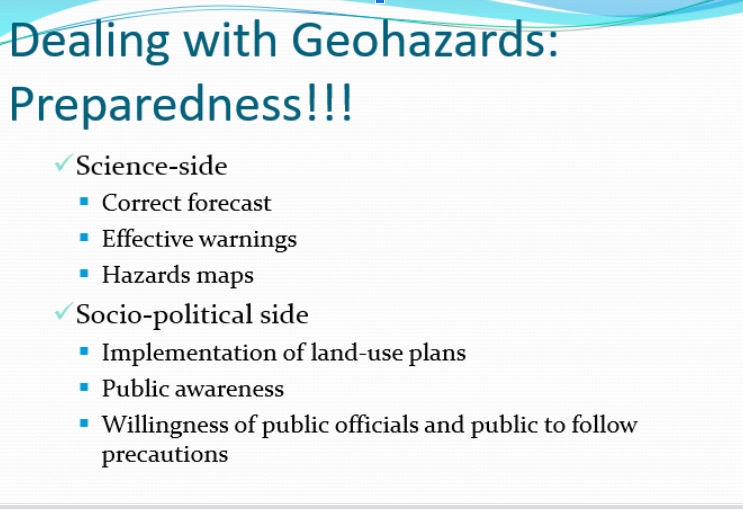
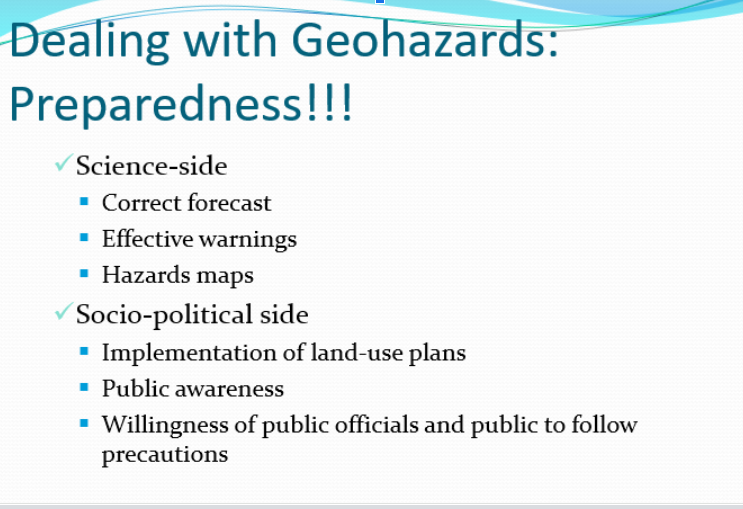
Yearly, the country experiences an average of twenty (20) tropical cyclones a year, seven to eight are destructive, including other weather hazards such as thunderstorm, heavy rainfall, southeast and northwest monsoons, cold front and ITCZ; is a host to more than 400 volcanoes, twenty-two (23) of which are active, together with active faults and trenches that are potential sources of earthquakes.
Yearly, the country experiences an average of twenty (20) tropical cyclones a year, seven to eight are destructive, including other weather hazards such as thunderstorm, heavy rainfall, southeast and northwest monsoons, cold front and ITCZ; is a host to more than 400 volcanoes, twenty-two (23) of which are active, together with active faults and trenches that are potential sources of earthquakes.
Water
plays an important role in controlling the stability of a slope
small
a (small/large) amount of water in pore space that is mostly occupied by air produces a capillary force, holding particles together
large
a (small/large) amount of water occupying all the pore space exerts pore pressure on the particles, keeping them apart
Trigger of Landslide: Water Input
Which trigger of landslide causes infiltration into unstable slope which then increases pore pressure (“loosens” particles) and adds more weight to slope, favoring failure?
Trigger of Landslide: Earthquake
Which trigger of landslide causes ground shaking that can facilitate slope failure?
Human activity
What activity can increase the risk of landslides in a number of ways?
Living with Landslides (U.S.)
25 to 50 lives are lost as a result of landslides in the U.S. every year.
Landslide-related property damage in the U.S. is on the order of $1-2 billion each year.
Hydrograph
portrays the time of heavy rainfall and peak discharge
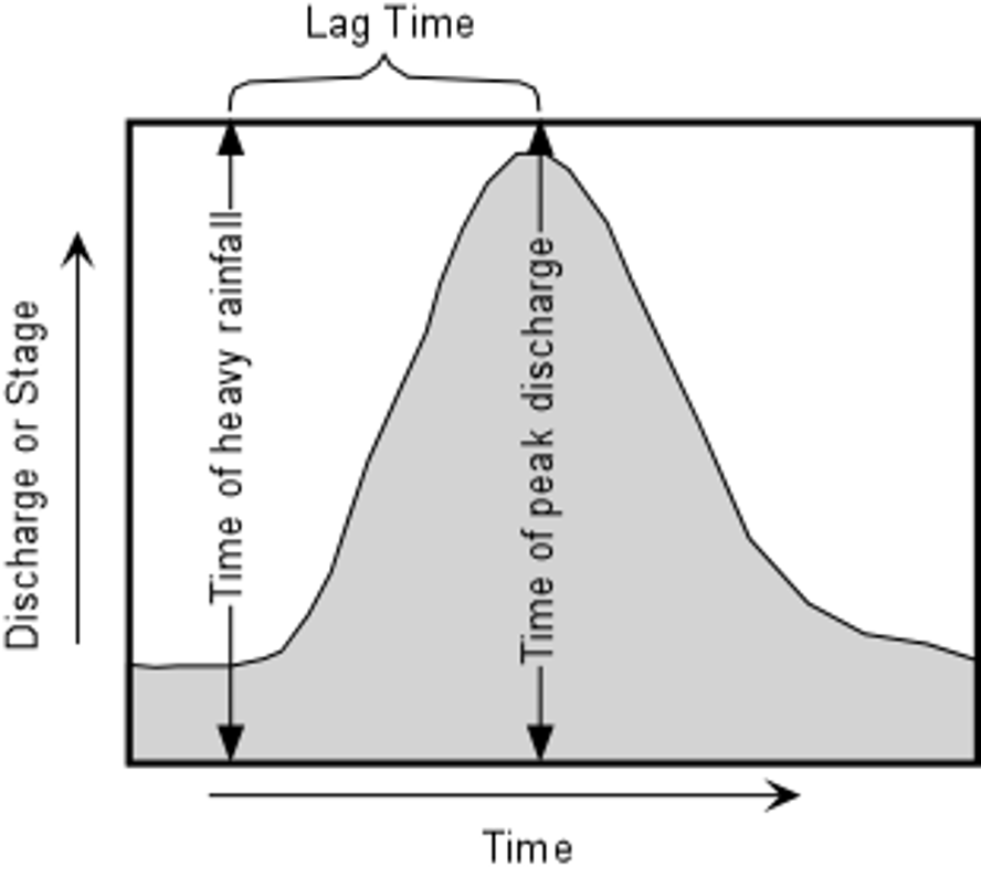
Flood Stages
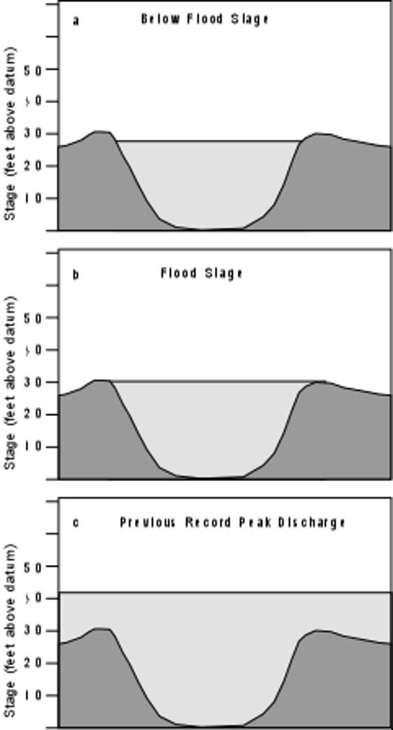
Lag Time
difference between time of heavy rainfall and time of peak discharge
time for river channel to be filled to its capacity before flooding
Short - causes Flash Flood
Long - Ideal to better prepare for a flood
Short vs. Long Lag Time
Flood Damage Prevention Program
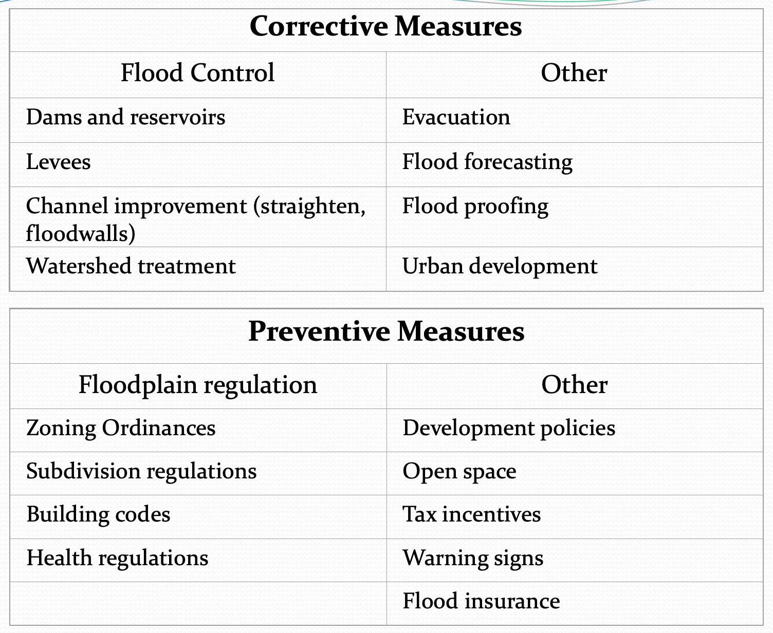
How to Respond to Hazard
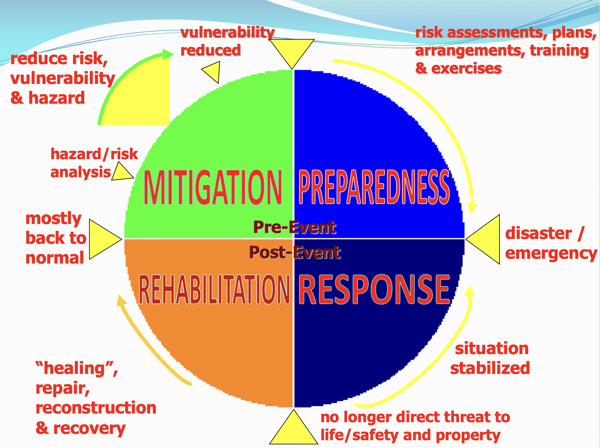
Community Based Disaster Risk Management Process
Organizing the technical working group
Training community leaders and members
Early warning system preparation
Community drills
Community reforestation and revegetation
Organizational Issues
Minimal institutional linkages between government agencies, academe and other sectors
National Government Programs (lead by NDCC-OCD)
e.g., geohazard mapping – mainly government agencies are involved (MGB, PHIVOLCS, PAGASA, NAMRIA)
Uncoordinated efforts
Capabilities and Capacities
Very few research scientists
Government agencies have very few research scientists
e.g. some government agencies tasked in certain geohazards have limited capabilities
Only 4 universities offer geology courses
Geoscientist is not an attractive career
Many engineers but few are engaged in research
Engineers are not tapped to help in geohazard assessment
Public Awareness
Disaster science has not permeated to grassroots level
People continue to live in hazardous areas – socio-economic condition, cultural
Hazardous Earth Materials
Asbestos cancer
Radon cell damage
Zeolite cancer
Cinnabar Minamata disease
Extraterestrial Hazards: Meteorite Impact
Mass extinction at 65Ma
Death of dinosaurs
Can it happen again???