aphug - unit 6
0.0(0)
Card Sorting
1/114
Earn XP
Description and Tags
Study Analytics
Name | Mastery | Learn | Test | Matching | Spaced |
|---|
No study sessions yet.
115 Terms
1
New cards
what are site factors (physical, location) that influence the origin function, and growth of cities?
* Climate
* Landforms
* Availability of water
* Soil fertility
* Landforms
* Availability of water
* Soil fertility
2
New cards
what are situation factors (what factors of the location influence the function of the city) influence the origin function, and growth of cities?
connections between sites (transportation) and relative location
3
New cards
what is an example of a site factor?
Cincinnati is on the north bank of the Ohio River and is a valley surrounded by hills with a temperate climate and fertile soil (geography of a region)
4
New cards
what is an example of a situation factor?
Cincinnati emerged as a river port after 1811. River commerce reached its height in 1852, stimulated steamboat building and industry, specifically pork. (the water geography created an industry around the port and water)
5
New cards
How does transportation and technology influence urbanization?
* Waterways railways and highways provide transportation of raw materials to factories, goods to markets, and let workers access jobs
* Transportation technology has led to the development of suburbs, urban sprawl, decentralization, growth and decline
* Transportation technology has led to the development of suburbs, urban sprawl, decentralization, growth and decline
6
New cards
What does the type of transportation say about a given location for housing?
Streetcars -------> people live by city center
Invention of cars --------> people move to suburbs
Invention of highways ------> businesses can move (anyone can travel to the business)
Invention of cars --------> people move to suburbs
Invention of highways ------> businesses can move (anyone can travel to the business)
7
New cards
How do advances in communication make communication easier?
Landlines ------> allowed for more options of communicating quicker, and more locally
Cell phones/Internet ------> allowed for international communication
5G ------> limitless communication
Cell phones/Internet ------> allowed for international communication
5G ------> limitless communication
8
New cards
First Stage of Borchert’s Epochs of American Urbanization
The Sail-Wagon Epoch (1790-1830)
* At first cities were clustered within sixty miles of the Atlantic sea coast
* Interior cities grew up on rivers with good access to the coast
* Cities relied on access to water
* At first cities were clustered within sixty miles of the Atlantic sea coast
* Interior cities grew up on rivers with good access to the coast
* Cities relied on access to water
9
New cards
Second Stage of Borchert’s Epochs of American Urbanization
The Iron Horse Epoch (1830-1870)
* Steam-driven railroads allowed for expansion from urban settlements into surrounding regions
* Regional rail networks connected cities and resources to industrial sites
* Steamboats increased the movement of goods and river cities emerged with significant growth
* Steam-driven railroads allowed for expansion from urban settlements into surrounding regions
* Regional rail networks connected cities and resources to industrial sites
* Steamboats increased the movement of goods and river cities emerged with significant growth
10
New cards
Third Stage of Borchert’s Epochs of American Urbanization
The Steel Rail Epoch (1870-1920)
* Transcontinental railways (across US)
* Industrial centers in the Northeast and Midwest continued to grow
* River cities, such as New Orleans, declined as rail centers such as Chicago, grew
* Chicago was the meeting point of railroads from the east and west and became central to the economy.
* Population & industry grew and thrived due to SITUATIONAL factors! (connections between many locations)
11
New cards
Fourth Stage of Borchert’s Epochs of American Urbanization
Auto-Air- Amenity Epoch (1920 to Present)
* Railroads decline and cars (through increased highway construction) allowed cities to spread out.
* Air travel increased and airport hubs emerged.
* Major urban growth in the Great Lakes region due to the automobile industry and in Sunbelt cities (southern cities with sunny climate)
* Railroads decline and cars (through increased highway construction) allowed cities to spread out.
* Air travel increased and airport hubs emerged.
* Major urban growth in the Great Lakes region due to the automobile industry and in Sunbelt cities (southern cities with sunny climate)
12
New cards
Where are communication networks mainly located?
Communication networks are historically the same as the trade networks because information travels along with goods
13
New cards
How did increases in modern communication technology have an impact economically?
Access to computers, telephones, and the internet results in decreased costs of communication and greater production
14
New cards
Rural-to-Urban Migration
* Due to economic and educational opportunities as well as services accessible in cities
* In 2017, 55% of the world living in urban areas
* Population in cities are expected to increase over time
* In 2017, 55% of the world living in urban areas
* Population in cities are expected to increase over time
15
New cards
What characterizes favelas/squatter settlements/slums?
\- A household that cannot provide one of the following basic living characteristics:
* Durable housing that protects against extreme climate conditions
* No more than three people sharing the same room.
* Easy access to safe water
* Access to adequate sanitation in the form of a private or public toilet shared by a reasonable number of people.
* Durable housing that protects against extreme climate conditions
* No more than three people sharing the same room.
* Easy access to safe water
* Access to adequate sanitation in the form of a private or public toilet shared by a reasonable number of people.
16
New cards
Why do squatter settlements develop?
\
Develop due to rapid population growth and urbanization in developing countries.
* Lack of affordable housing
Develop due to rapid population growth and urbanization in developing countries.
* Lack of affordable housing
17
New cards
Where are squatter settlements built?
In developing countries usually built on the outskirts of a city on undesirable land
* Typically will have higher rates of disease and malnutrition, pollution, vulnerability to natural disasters, and a variety of social problems.
* Typically will have higher rates of disease and malnutrition, pollution, vulnerability to natural disasters, and a variety of social problems.
18
New cards
Example of squatter settlement/favela/slum?
Favelas in Rio de Janeiro, Brazil
* 70,000 residents on the outskirts of the city living on the steep hills that are susceptible to landslides
* 70,000 residents on the outskirts of the city living on the steep hills that are susceptible to landslides
19
New cards
How does the economic function of a city effect why people will live there?
* The primary source of income for a city, can effect why people will live there
* __Government:__ Washington, D.C.
* __Manufacturing and Industry:__ Houston, TX functions as the center of the oil and energy industry.
* __Tourism:__ Cancun, Mexico; Miami, FL; Las Vegas, NV
* __Services:__ Wall St., NYC -> Financial Center
* __Government:__ Washington, D.C.
* __Manufacturing and Industry:__ Houston, TX functions as the center of the oil and energy industry.
* __Tourism:__ Cancun, Mexico; Miami, FL; Las Vegas, NV
* __Services:__ Wall St., NYC -> Financial Center
20
New cards
How can governments attract businesses in order to boost the economy?
* Offer tax incentives
* Financial incentives
* Creation of industrial parks,
* Land zoning for industrial or commercial uses
* Transportation infrastructure
* Low crime
* Affordable housing
* Good schools
* Entertainment & leisure
* Financial incentives
* Creation of industrial parks,
* Land zoning for industrial or commercial uses
* Transportation infrastructure
* Low crime
* Affordable housing
* Good schools
* Entertainment & leisure
21
New cards
Forward Capitals
* Capital cities that are relocated, mostly occurring in former colonies
* Relocated typically due to limited infrastructure, and the desire to build new, planned administrative centers with improved infrastructure
* Replaced Rio de Janeiro in Brazil to a more centrally located city Brasillia
* Relocated typically due to limited infrastructure, and the desire to build new, planned administrative centers with improved infrastructure
* Replaced Rio de Janeiro in Brazil to a more centrally located city Brasillia
22
New cards
Megacity
* Metropolitan areas with populations of more than 10 million people
* Mostly in periphery and semi-periphery countries
* Population growth due to birth rates over death rates as well as rural to urban migration
* Unplanned growth leads to growth of squatter settlements
* Mostly in periphery and semi-periphery countries
* Population growth due to birth rates over death rates as well as rural to urban migration
* Unplanned growth leads to growth of squatter settlements
23
New cards
Metacities
Metropolitan areas with populations of more than **20 million people.**
24
New cards
How did increased access to the automobile effect commercial developments?
Greater access to automobiles both roads and commercial developments have expanded outward from the city center
* RESULTED IN new land use forms:
* Suburbs
* Edge cities
* Boombubs
* Exurbs
* RESULTED IN new land use forms:
* Suburbs
* Edge cities
* Boombubs
* Exurbs
25
New cards
Sub-urbanization
The process of people moving, usually from cities, to residential areas on the outskirts of cities.
* Forms communities that are connected to the city for jobs and services but are farther and slightly more spread out
* Less densely populated and less ethnically diverse than cities
* Developed due to advancements in transportation that allowed workers to live further than walking distance from their jobs.
26
New cards
Sub-urbanization after WII
\
* After WWII in America, economic advancements increased production & ownership of automobiles resulting in the increase of suburbs.
* GI Bill provided veterans with low down payment terms and long-term mortgages
* Neighborhoods were developed with tract/prefab housing that could be built quickly
* After WWII in America, economic advancements increased production & ownership of automobiles resulting in the increase of suburbs.
* GI Bill provided veterans with low down payment terms and long-term mortgages
* Neighborhoods were developed with tract/prefab housing that could be built quickly
27
New cards
Edge Cities
Community located on the outskirts of a larger city with commercial centers, office space, retail complexes, and amenities typically found in an urban center.
* Not usually residential - mostly economic activities.
* Newly developed in the past 30 years.
* Not usually residential - mostly economic activities.
* Newly developed in the past 30 years.
28
New cards
Boomburbs
Suburb that has grown rapidly into a large and sprawling city with more than 100,000 residents. Typically made up of planned communities that have began to merge together.
* “Feels” suburban, but more closely resembles an urban city in population
* “Feels” suburban, but more closely resembles an urban city in population
29
New cards
Exburbs
Community on the outside edge of traditional suburbs, “exurban.” Function like a suburb, but more rural and less connected to the central city core.
* Low-density residential communities
* May include wealthy estates or small rural towns.
* Little diversity
* (Shoreham-Wading River)
* Low-density residential communities
* May include wealthy estates or small rural towns.
* Little diversity
* (Shoreham-Wading River)
30
New cards
\
Negative Effects of Suburbization
Negative Effects of Suburbization
* Placelessness, lack of identity or culture
* Dependence on automobiles results in pollution and traffic congestion
* Government investment in continued suburban growth resulted in a lack of investment in inner cities
* Dependence on automobiles results in pollution and traffic congestion
* Government investment in continued suburban growth resulted in a lack of investment in inner cities
31
New cards
\
Negative Effects of Urban Sprawl
Negative Effects of Urban Sprawl
* Economically exclusive - often those who remain in the city are in poverty and do not pay enough taxes to sustain the urban core.
* Leads to economic decline, urban decay
* Leads to economic decline, urban decay
32
New cards
World Cities
Large cities that exert global economic, cultural, and political influence and make up a network of economic, social, and information flows.
* Globalizing cities at the top of the world’s urban hierarchy that are all connected.
* Media hubs and financial centers with influential stock exchanges, banks, and corporate headquarters and international organizations.
* Fashion, design, entertainment, and cultural industries.
* Globalizing cities at the top of the world’s urban hierarchy that are all connected.
* Media hubs and financial centers with influential stock exchanges, banks, and corporate headquarters and international organizations.
* Fashion, design, entertainment, and cultural industries.
33
New cards
What results from connections between world cities?
Interconnection and globalization networks between world cities provide:
* Diffusion of new ideas, goods, services.
* Manufacturing and Trading
\
* Transportation
* Banking
* Communication
* Popular Culture & Tourism
* Olympics, Fashion Week, Times Square, Buckingham Palace
* Diffusion of new ideas, goods, services.
* Manufacturing and Trading
\
* Transportation
* Banking
* Communication
* Popular Culture & Tourism
* Olympics, Fashion Week, Times Square, Buckingham Palace
34
New cards
Urban Hierarchy
\
* Modern cities operate within an interconnected urban hierarchy.
* Different cities have different functions within the system, with larger, more influential cities landing higher on the hierarchy, while cities with smaller populations and economies fall lower on the hierarchy.
* Models & theories were developed by geographers in order to explain the relative sizes and spatial organization of cities.
35
New cards
What is the rank-size rule?
\
* Model that illustrates the relationship between population distribution in cities that are interconnected in the urban hierarchy. Typically indicates somewhat even development.
* Population of the **2**nd largest city = 1/**2** the population of the largest city.
* Population of the **3**rd largest city = 1/**3** the population of the largest city.
* Population of the **4**th largest city = 1/**4** the population of the largest city.
* ex: largest = 100, second = 50, third = 33, fourth = 25
36
New cards
Gravity Model
\
* Considers the distance between two locations and their relative sizes (the size is more important than location)
* Larger cities interact more often with other large cities, rather than small cities.
* Small cities are drawn to the influence and impact of large cities
* The shorter the difference in size between the two cities, the higher chance of flow between the two cities
* Estimates traffic flows, migration between two areas, number of people likely to use one central place
37
New cards
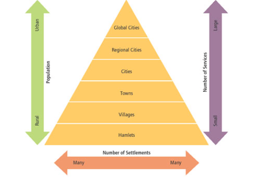
Christaller’s Central Place Theory
* Model that illustrates the hierarchical spatial __patterns/order__ of cities and settlements.
* Based on economic functions/consumer behavior - the “central place” is the large city that provides the most goods and services for the surrounding areas.
* Smaller settlements (towns, villages, hamlets) organize around the “central place.”
* Organized in hexagons to assure no surface area is left out or overlapped
* The city center is situated in the center of the region it serves, directly between the towns
38
New cards
Threshold
* The number of people needed to support a certain good or service.
39
New cards
Range
* The distance that someone is willing to travel for a good or service.
40
New cards
* __High-Order Goods & Services__
Expensive, desirable or unique goods or services - large threshold & range (need a lot of people for the service, and people are willing to travel far for it). Typically found in higher-order locations, such as major cities.
Examples: sports games in arenas, specialty doctors, concerts, universities
Examples: sports games in arenas, specialty doctors, concerts, universities
41
New cards
Low-Order Goods & Services
* Inexpensive, common, everyday needs. SMALLER threshold & range. (less people needed for service and people are not as willing to travel far)Typically found in lower-order locations, such as towns, villages, and hamlets.
* Examples: Grocery stores, hair salons, barber shops, gas stations.
\
* Examples: Grocery stores, hair salons, barber shops, gas stations.
\
42
New cards
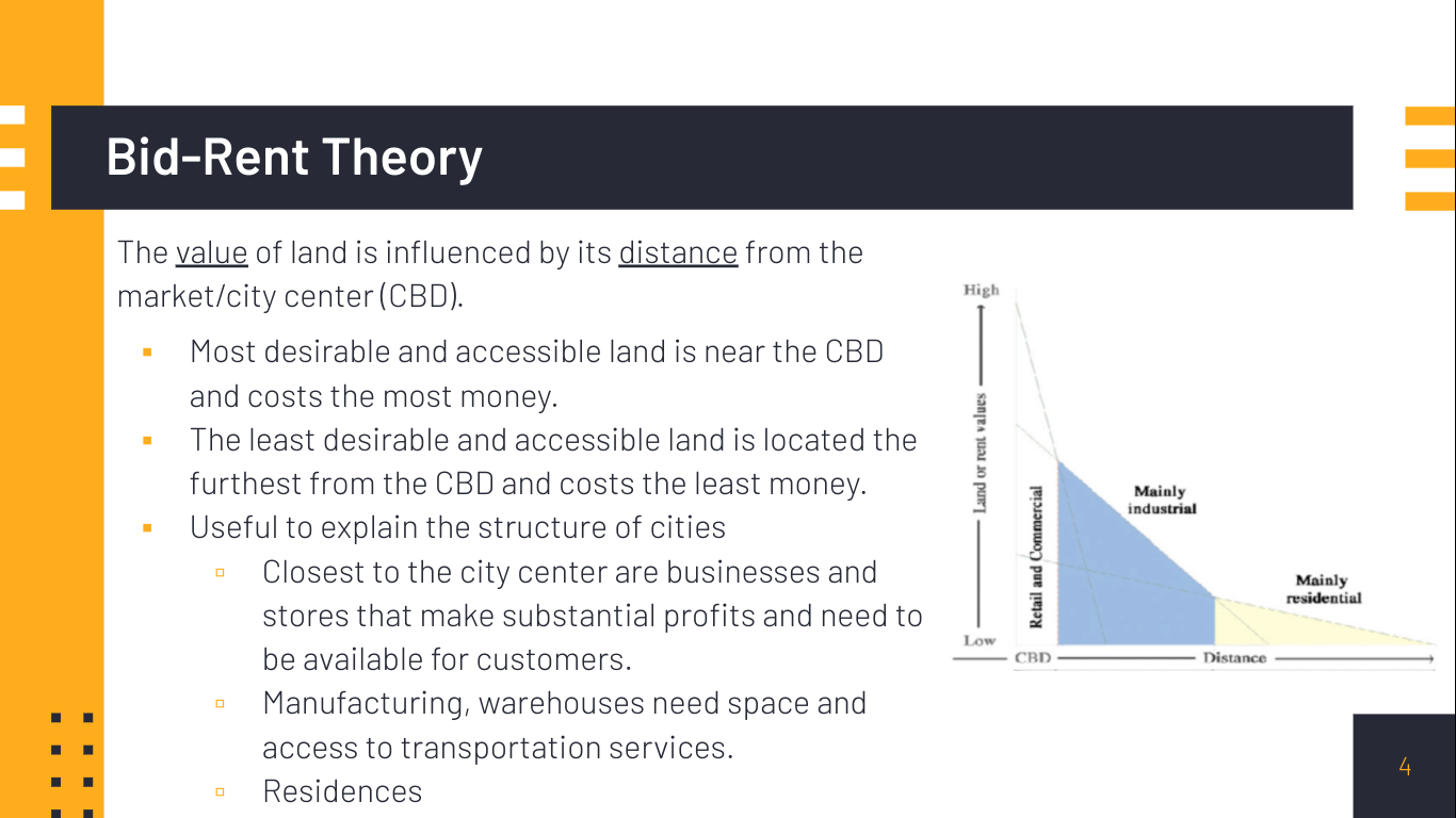
Bid-Rent Theory
The __value__ of land is influenced by its __distance__ from the market/city center (CBD).
* Most desirable and accessible land is near the CBD and costs the most money.
* The least desirable and accessible land is located the furthest from the CBD and costs the least money.
* Useful to explain the structure of cities
* Closest to the city center are businesses and stores that make substantial profits and need to be available for customers.
* Manufacturing, warehouses need space and access to transportation services.
* Residences
43
New cards
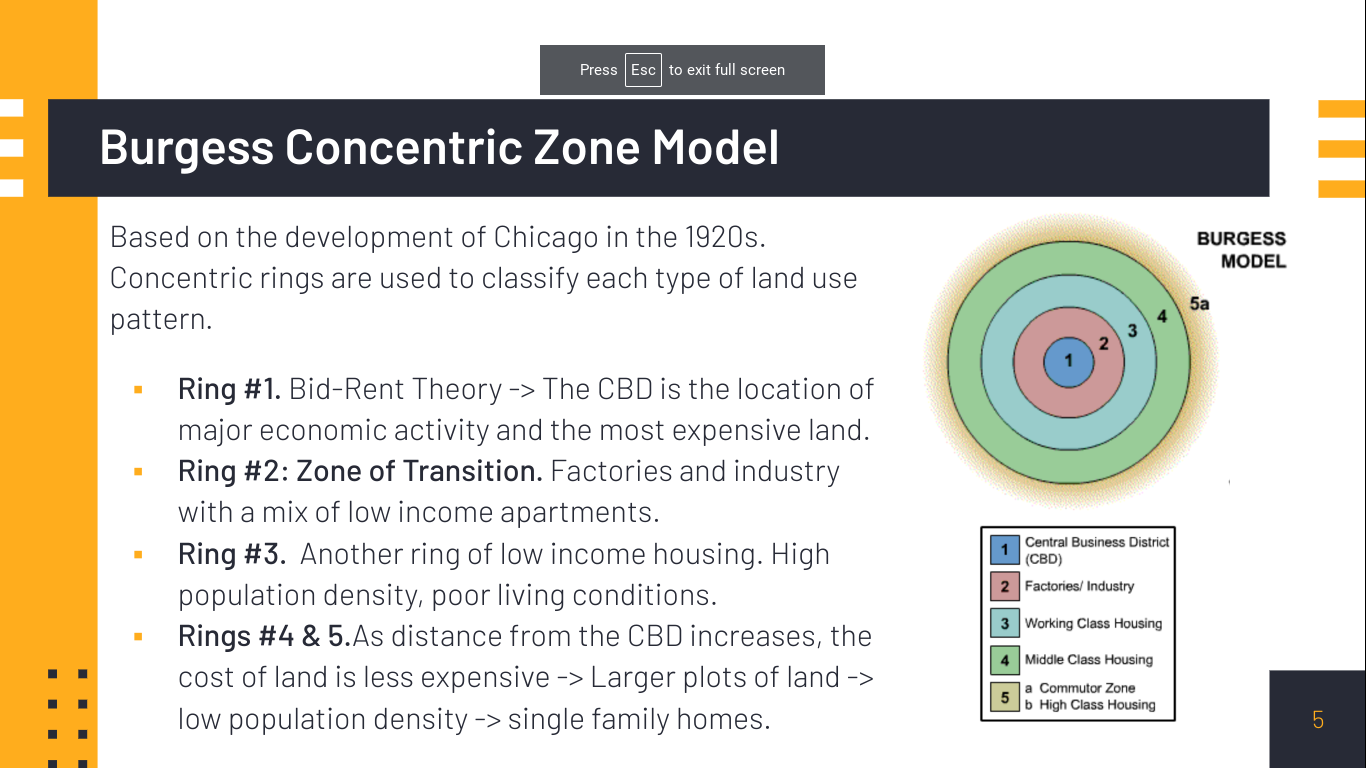
Burgess Concentric Zone Model
Based on the development of Chicago in the 1920s. Concentric rings are used to classify each type of land use pattern.
* Ring #1. Bid-Rent Theory -> The CBD is the location of major economic activity and the most expensive land.
* Ring #2: Zone of Transition. Factories and industry with a mix of low income apartments.
* Ring #3. Another ring of low income housing. High population density, poor living conditions.
* Rings #4 & 5.As distance from the CBD increases, the cost of land is less expensive -> Larger plots of land -> low population density -> single family homes.
44
New cards
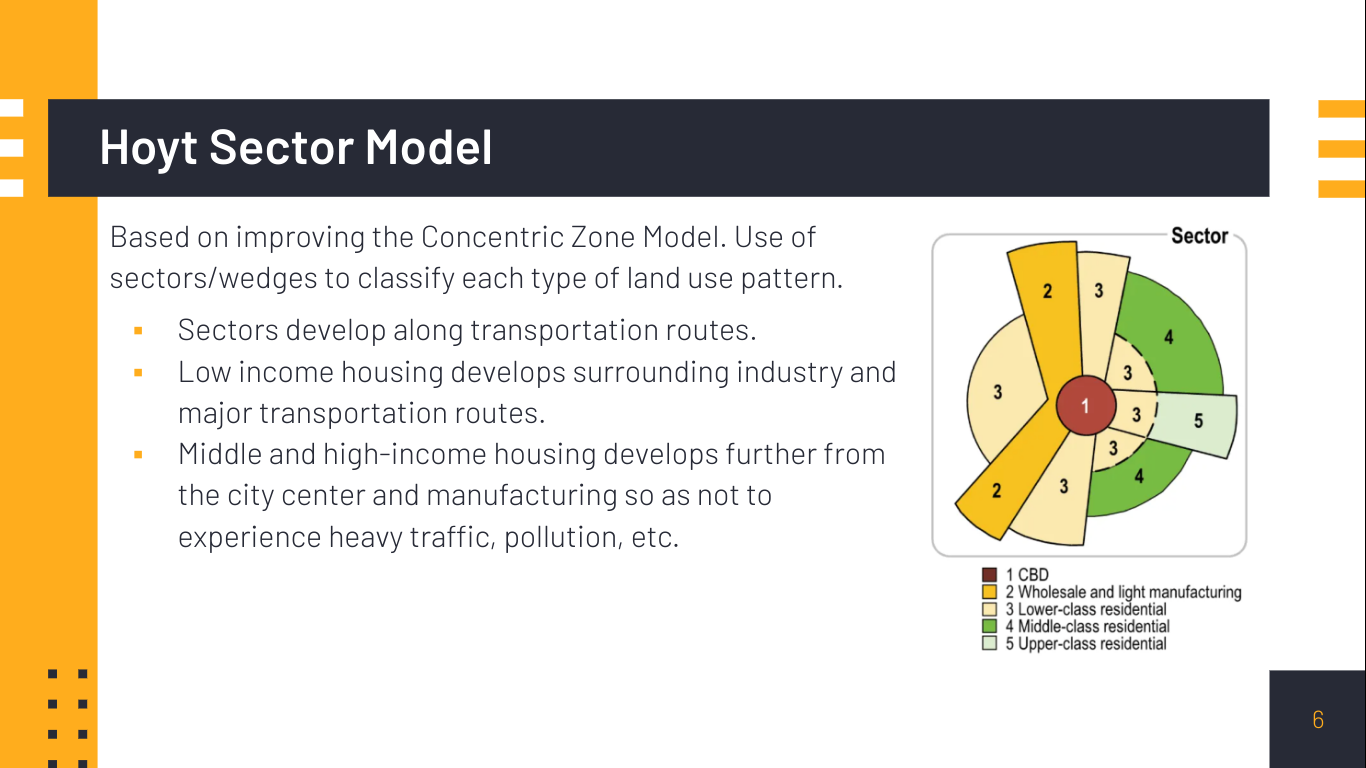
Hoyt Sector Model
Based on improving the Concentric Zone Model. Use of sectors/wedges to classify each type of land use pattern.
* Sectors develop along transportation routes.
* Low income housing develops surrounding industry and major transportation routes.
* Middle and high-income housing develops further from the city center and manufacturing so as not to experience heavy traffic, pollution, etc.
* Sectors develop along transportation routes.
* Low income housing develops surrounding industry and major transportation routes.
* Middle and high-income housing develops further from the city center and manufacturing so as not to experience heavy traffic, pollution, etc.
45
New cards
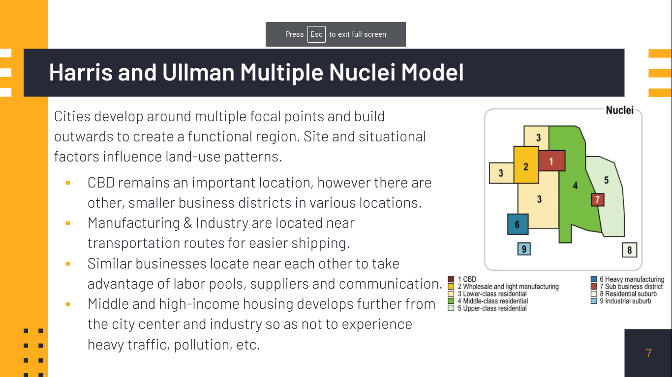
Harris and Ullman Multiple Nuclei Model
Cities develop around multiple focal points and build outwards to create a functional region. Site and situational factors influence land-use patterns.
* CBD remains an important location, however there are other, smaller business districts in various locations.
* Manufacturing & Industry are located near transportation routes for easier shipping.
* Similar businesses locate near each other to take advantage of labor pools, suppliers and communication.
* Middle and high-income housing develops further from the city center and industry so as not to experience heavy traffic, pollution, etc.
46
New cards
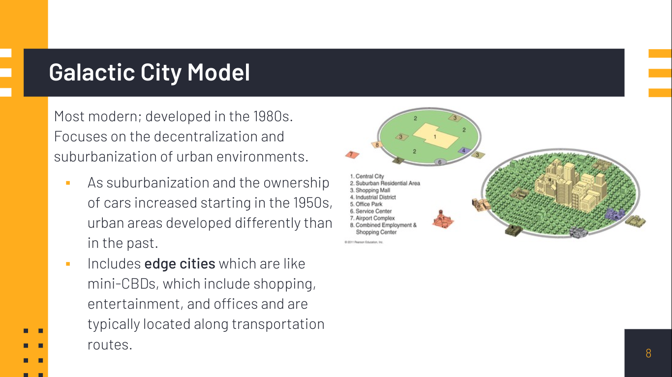
Galactic City Model
Most modern; developed in the 1980s. Focuses on the decentralization and suburbanization of urban environments.
* As suburbanization and the ownership of cars increased starting in the 1950s, urban areas developed differently than in the past.
* Includes edge cities which are like mini-CBDs, which include shopping, entertainment, and offices and are typically located along transportation routes.
* As suburbanization and the ownership of cars increased starting in the 1950s, urban areas developed differently than in the past.
* Includes edge cities which are like mini-CBDs, which include shopping, entertainment, and offices and are typically located along transportation routes.
47
New cards
What factors most impacted how an why cities developed in the US over time?
transportation and innovation
48
New cards
Population Density
the amount of people that occupy a specific unit of land
49
New cards
Residental
a term to describe places in which people reside.
50
New cards
what is an example of high density residental?
cities, apartments, urban
51
New cards
what is an example of medium density residental?
condos, suburban
52
New cards
what is an example of low density residental?
rural, spread out homes with large yards
53
New cards
Land use in older international cities
Older international cities (Paris, Toyoko, Amsterdam) developed before advancements in transportation technology…
* Therefore, land use is organized so that residential areas, areas of work and business, and services are all within walking distance of one another.
* Results in...More apartment buildings in the city center, higher population densities, less space for the use of cars, families are more likely to gather in public places.
* This is why streets are narrow in Spain and Italy, they were built before cars
54
New cards
Land use in newer cities
Newer cities, such as many in the US were developed around transportation technology that enabled people to travel longer distances from their homes to work or services.
* Transportation technology impacts residential land use- people can move to suburban areas with larger plots of land due to the availability of the automobile.
* Results in...development of suburbs, suburban sprawl, economic and ethnic segregation, more air pollution, culture of privacy.
* Transportation technology impacts residential land use- people can move to suburban areas with larger plots of land due to the availability of the automobile.
* Results in...development of suburbs, suburban sprawl, economic and ethnic segregation, more air pollution, culture of privacy.
55
New cards
Zoning
* a regulation about what type of development or land use can occur in a specific location
* zoning policies are created by municipal (local) governments and impact residential land use
Examples:
* Residential, commercial, or industrial
* Are you allowed to place a noisy, dirty factory next to a suburban neighborhood?
* Are you allowed to build skyscraper apartments, or can they only be three floors high?
56
New cards
Municipal
local
57
New cards
How can zoning impact residential density?
If a zone was changed from only allowing the development of single family homes to allowing apartment buildings.
* This would increase the housing density of a location while also increasing affordable housing and access to infrastructure and high-quality services.
* This would increase the housing density of a location while also increasing affordable housing and access to infrastructure and high-quality services.
58
New cards
Infilling
Redevelopment of vacant land to improve the surrounding area.
* Previous industrial areas can be converted to offices, housing, and entertainment venues.
* Increases the density of the area and changes the land use pattern.
* Previous industrial areas can be converted to offices, housing, and entertainment venues.
* Increases the density of the area and changes the land use pattern.
59
New cards
what is infrastructure?
the basic support systems needed to keep a society and economy running smoothly.
Examples include:
* Transportation systems
* Power stations & lines
* Wifi
* Sewage systems
* Schools
* Police and Fire Departments
* Hospitals
Examples include:
* Transportation systems
* Power stations & lines
* Wifi
* Sewage systems
* Schools
* Police and Fire Departments
* Hospitals
60
New cards
How does the location and quality of a city’s infrastructure POSITIVELY affect a city’s economic and social development?
* Locations within a city that have high quality infrastructure are typically more economically and socially developed.
* Infrastructure is typically funded by the government via tax revenue. So, more economically prosperous areas will have better infrastructure.
* Where? Capitals, high-income areas of the city, core countries are more developed
* Infrastructure is typically funded by the government via tax revenue. So, more economically prosperous areas will have better infrastructure.
* Where? Capitals, high-income areas of the city, core countries are more developed
61
New cards
How does access to a strong network of hospitals encourage social development?
* Treatment and prevention of disease and illness, less sick people, less spread of illness, healthier population.
* Available jobs in healthcare settings employ people living around the hospital, less unemployment.
* Available jobs in healthcare settings employ people living around the hospital, less unemployment.
62
New cards
How does access to transportation routes encourage economic development?
* Businesses have a reliable way to transport goods, make $, hire more workers.
* Employees are able to easily travel to and from work, make $, spend money to stimulate economy.
* Employees are able to easily travel to and from work, make $, spend money to stimulate economy.
63
New cards
How does the location and quality of a city’s infrastructure NEGATIVELY affect a city’s economic and social development?
* Locations within a city that have low quality infrastructure are typically less economically and socially developed.
* Infrastructure may be informally developed by people due to lack of assistance from the government.
* Favelas/squatter settlements, low income neighborhoods, periphery and semi-periphery countries
* Infrastructure may be informally developed by people due to lack of assistance from the government.
* Favelas/squatter settlements, low income neighborhoods, periphery and semi-periphery countries
64
New cards
How does a lack of access to hospitals negatively impact social development?
* Less treatment and prevention of disease and illness, more sick people, more spread of illness, unhealthy population.
* Less high-paying jobs available
* Less high-paying jobs available
65
New cards
How does a lack of access to transportation routes negatively impact economic development?
* Businesses cannot reliably transport goods, make less money, spend more on transportation.
* Employees are unable to easily travel to work, less productivity, more money spent on transportation rather than stimulating the economy.
* Employees are unable to easily travel to work, less productivity, more money spent on transportation rather than stimulating the economy.
66
New cards
How does infrastructure take advantage of non-renewable resources?
Coal is used to generate electricity that pollutes the air
67
New cards
What care the characteristics of a sustainable city?
A sustainable city…
1: Reduces the city’s impact on the environment.
2: Has Livability, high quality of life with opportunity and stability that includes
* Education
* Availability of employment
* Access to transportation
* Economic prosperity
* Entertainment
* Social Supports
1: Reduces the city’s impact on the environment.
2: Has Livability, high quality of life with opportunity and stability that includes
* Education
* Availability of employment
* Access to transportation
* Economic prosperity
* Entertainment
* Social Supports
68
New cards
Smart Growth and New Urbanism
\
* Types of sustainable urban design policies - oftentimes used interchangeably.
* Attempt to reduce urban sprawl and develop urban spaces that are sustainable, efficient and environmentally conscious.
* Utilization of mixed-use zoning (both residental and commercial in one area) policies in order to increase the use of already existing urban structures, create walkable and liveable cities while maintaining a sense of place and increasing residential housing density.
69
New cards
Mixed-Use Development
* Planned urban development that includes multiple uses such as retail, residential, educational, recreational and businesses.
* Different from traditional zoning policies that only allow one type of development - residential, commercial, or industrial.
* Intended to increase residential density and reduce commute and travel times.
* Hallmark characteristic of smart growth policies and New Urbanism.
* Example: condos/apartments located on top of retail spaces that make travel times walkable and easy
70
New cards
Walkability
* Walkability provides urban residents with safe, convenient and efficient ways to walk or bicycle to important places.
* Characteristic of mixed-use developments.
* Greatly decreases urban sprawl and pollution.
* Implement infrastructure to safely accommodate and encourage pedestrians and bicyclists
* Characteristic of mixed-use developments.
* Greatly decreases urban sprawl and pollution.
* Implement infrastructure to safely accommodate and encourage pedestrians and bicyclists
71
New cards
Transportation Oriented Development
* Access to public transportation is another aspect of sustainable urban development.
* Busses
* Subway Systems
* Commuter Train Lines
* Decreases air pollution, reduces traffic congestion and allows for valuable urban land to be used to create mixed-use developments instead of parking lots.
* 40% of residents in Washington, DC use public transportation to get to work.
* Busses
* Subway Systems
* Commuter Train Lines
* Decreases air pollution, reduces traffic congestion and allows for valuable urban land to be used to create mixed-use developments instead of parking lots.
* 40% of residents in Washington, DC use public transportation to get to work.
72
New cards
Greenbelts
\
* An area of green space such as a park, agricultural land, or forest around an urban area intended to limit urban sprawl.
* Also sometimes referred to as an urban growth boundary.
* Protected area that helps limit pollution, protects local wildlife habitats.
* A characteristic of sustainable urban design
* Historically used in GREAT BRITAIN
73
New cards
Slow Growth Cities
\
* Another sustainable urban design policy that intends to decrease the rate that cities grow outward in an attempt to reduce urban sprawl.
* This can be achieved by implementing greenbelts or by using zoning policies to restrict the development of land.
* Utilizes urban growth boundaries to place a geographic limit on development surrounding a city.
74
New cards
Positives of Sustainable Urban Design
\
* Reduction of sprawl
* Improved walkability
* Improved transportation
* Improved and diverse housing options
* Improved livability
* Reduction in pollution
* Reduction of sprawl
* Improved walkability
* Improved transportation
* Improved and diverse housing options
* Improved livability
* Reduction in pollution
75
New cards
Negatives of Sustainable Urban Design
\
* Increased housing costs
* New developments are desirable so real estate prices rise and are not affordable for low income residents.
* De facto segregation
* Low income families and people of color can no longer afford to live in the city and are forced to move out.
* Potential loss of historical or place character. Placelessness.
76
New cards
Qualitative Data
Data that involves descriptive depictions or characteristics of a research topic - often based on people’s perceptions or opinions.
* Examples include fieldwork (remember this from 1.2?) and narratives, personal interviews, photographs.
* Open-ended questions about how individuals feel about urban change and conditions such as growth, zoning changes, crime rates, traffic, etc.
* Examples include fieldwork (remember this from 1.2?) and narratives, personal interviews, photographs.
* Open-ended questions about how individuals feel about urban change and conditions such as growth, zoning changes, crime rates, traffic, etc.
77
New cards
Quantitative Data
Data that involves numbers and statistics - can be measured.
* Examples include the Census (remember from 1.3 & 4.6?) and other surveys as well as population or development statistics.
* Useful to provide information to city governments about changes in population composition and size of urban areas.
* Examples include the Census (remember from 1.3 & 4.6?) and other surveys as well as population or development statistics.
* Useful to provide information to city governments about changes in population composition and size of urban areas.
78
New cards
How are urban areas changing?
* Urban uses have shifted from industrial to services
* Changing tax bases - rising costs to maintain or update infrastructure
\
* Many different people of different backgrounds and socioeconomic statuses
* Division about important issues
* Patterns of poverty or decay
* Changing tax bases - rising costs to maintain or update infrastructure
\
* Many different people of different backgrounds and socioeconomic statuses
* Division about important issues
* Patterns of poverty or decay
79
New cards
Redlining
Housing discriminaiton maintained by banks - starting in the 1930s, refusal to grant home loans in certain areas because of the ethnic or racial composition.
* Government created program in the 1930s that identified areas of *“poor investment”* which were in neighborhoods that were primarily made up of African-American residents.
* Black buyers were restricted from obtaining loans to buy or improve homes in those areas - fell into disrepair, poverty, maintained segregation
80
New cards
Blockbusing
Housing discimination maintained by real estate industry - white families were encouraged to rapidly sell when African-American families moved into neighborhoods.
* Fear-based, white residents were told that property values would rapidly decrease. So, they sold their homes quickly and at below-market prices.
* Black families were charged higher rates to buy.
* Changed the racial composition of neighborhoods, benefited the real estate agents making the sale.
* Fear-based, white residents were told that property values would rapidly decrease. So, they sold their homes quickly and at below-market prices.
* Black families were charged higher rates to buy.
* Changed the racial composition of neighborhoods, benefited the real estate agents making the sale.
81
New cards
How were redlining and blockbusting made illegal?
Redlining and blockbusting were made illegal with the Fair Housing Act of 1968, however residential segregation in cities still exists today.
82
New cards
How has it been made more difficult for the average American family to afford a home?
Rising mortgage rates, expensive home prices, low inventory and inflation make it difficult to afford a home
83
New cards
how are services more difficult to access in low income populations?
Urban areas with primarily low-income populations will lack transportation to access services
84
New cards
Food deserts
* Lack of access to healthy food options, restricted due to absence of grocery stores within convenient distance
* More abundant gas stations, corner stores and fast food
* Higher prices with low-quality and unhealthy foods
* Results in health issues such as diabetes, heart disease, and obesity
* More abundant gas stations, corner stores and fast food
* Higher prices with low-quality and unhealthy foods
* Results in health issues such as diabetes, heart disease, and obesity
85
New cards
Unhealthy Drinking Water
\
* Lead exposure through underground lead pipes that deliver drinking water contaminate water supplies.
* Health impacts are mostly observed in low-income, minority communities.
* Lead poisoning can lead to lower IQ, learning disabilities, increased crime, irritability, mood disorders, developmental delays.
86
New cards
Rising Crime
When people are economically and racially segregated in urban areas, crime increases. Factors that impact this include:
* Lack of job opportunities
* Lack of resources and infrastructure
* Desperation and isolation
* Criminalization of homelessness and mental health issues (exacerbated by lack of access to healthcare services)
* Lack of job opportunities
* Lack of resources and infrastructure
* Desperation and isolation
* Criminalization of homelessness and mental health issues (exacerbated by lack of access to healthcare services)
87
New cards
Environmental Injustice
Communities of color and the poor are more likely to be exposed to environmental burdens such as air and water pollution.
* Manufacturing and waste disposal
* Highways and congestion
* Use of lead in paint or pipes that supply water to homes
* Prevalence of renters that cannot fix home issues themselves
* Food deserts
* Manufacturing and waste disposal
* Highways and congestion
* Use of lead in paint or pipes that supply water to homes
* Prevalence of renters that cannot fix home issues themselves
* Food deserts
88
New cards
Growth of Disamenity Zones
Locations that are typically physically unsafe with dangerous terrain that are not connected to city services.
* High crime rates and gang presence
* High poverty
* Flood-prone
* Rail lines, landfills, or industry
* Slums or squatter settlements
* Homelessness
* Example: favelas in Brazil
* High crime rates and gang presence
* High poverty
* Flood-prone
* Rail lines, landfills, or industry
* Slums or squatter settlements
* Homelessness
* Example: favelas in Brazil
89
New cards
Growth of Zones of Abandonment
\
Locations that have been abandoned due to a lack of jobs, housing opportunities, decline in land values or falling demand.
Locations that have been abandoned due to a lack of jobs, housing opportunities, decline in land values or falling demand.
90
New cards
Negative effects of Housing Issues and Discrimination
* Lack of access to services or transportation
* Food deserts
* Lack of healthy drinking water
* Lack of access to healthcare
* High crime
* Environmental Injustice/Pollution
* Growth of Disamenity zones
* Growth of Zones of Abandonment
* Food deserts
* Lack of healthy drinking water
* Lack of access to healthcare
* High crime
* Environmental Injustice/Pollution
* Growth of Disamenity zones
* Growth of Zones of Abandonment
91
New cards
Causes of Housing Issues and Discrimination
Redlining, Blockbusting, Affordability
92
New cards
Squatter Settlements
\
* Residential areas that are situated on undesirable/ abandoned land that are built with found materials and not connected to city services.
* Also referred to as slums, favelas, barrios, etc.
* Squatters have no legal rights to land and can be forcibly evicted by governments, resulting in further homelessness and lack of affordable housing
93
New cards
Land Tenure
the legal rights to land
94
New cards
Inclusionary Zoning
Areas where city governments require that developers must include low and medium income housing options in their projects to obtain building permits.
* Effort to provide more affordable housing. People who are working in urban areas are often not able to afford to live there due to high prices.
* Common in the US and similar programs are utilized in London; not likely seen in periphery and semi-periphery locations.
\
* Effort to provide more affordable housing. People who are working in urban areas are often not able to afford to live there due to high prices.
* Common in the US and similar programs are utilized in London; not likely seen in periphery and semi-periphery locations.
\
95
New cards
Local Food Movements
Using city-owned land or abandoned areas to plant community, urban gardens to provide fresh fruit and vegetables to people living in food deserts.
* Residents sometimes are also able to sell and obtain a profit from urban gardens.
* Creates urban green spaces and generates community and job growth.
* Residents sometimes are also able to sell and obtain a profit from urban gardens.
* Creates urban green spaces and generates community and job growth.
96
New cards
Farmer’s Markets
Informal markets in which farmers bring in fresh food options to sell in urban areas.
97
New cards
Urban Renewal
Programming funded by federal government grants after WWII intended to redevelop and modernize blighted, abandoned and/or industrial urban areas.
\
After demolition, new housing and infrastructure such as highways, schools, hospitals and business developments were built in an effort to improve urban living conditions.
\
After demolition, new housing and infrastructure such as highways, schools, hospitals and business developments were built in an effort to improve urban living conditions.
98
New cards
Gentrification
The process by which higher income residents or professional developers buy buildings in abandoned, blighted and/or industrial areas for a low cost and renovate, restore or rebuild the property.
\
* Similar intention as urban renewal, however the developers or residents will oftentimes resell after “flipping” the property for a higher price than they paid to purchase.
\
* Similar intention as urban renewal, however the developers or residents will oftentimes resell after “flipping” the property for a higher price than they paid to purchase.
99
New cards
Positive effects of Urban Renewal and Gentrification
\
* Improved housing and increased property values and tax revenues.
* Attract new business and investors that stimulate economic growth and jobs.
* Infrastructure improvements such as sidewalks, schools, parks, wifi, roads, etc.
* Rehabilitation of historic buildings - maintenance of the city’s cultural landscape.
* Decreased crime rates.
100
New cards
Negative effects of Urban Renewal and Gentrification
\
* Displacement of long-time residents of locations which are typically elderly, minority, and/or impoverished people.
* Homelessness, social tensions
* Demolition or alteration of historic buildings by new businesses - may contribute to placelessness and lack of community.
* Displacement of long-time residents of locations which are typically elderly, minority, and/or impoverished people.
* Homelessness, social tensions
* Demolition or alteration of historic buildings by new businesses - may contribute to placelessness and lack of community.