Geology Exam 2
1/35
There's no tags or description
Looks like no tags are added yet.
Name | Mastery | Learn | Test | Matching | Spaced | Call with Kai |
|---|
No analytics yet
Send a link to your students to track their progress
36 Terms
Chronostratigraphy
the branch of geology that studies rock strata in relation to time, focusing on the age and distribution of rock layers.
radiometric age dating
a method used to determine the age of rocks or fossils by measuring the decay of radioactive isotopes.
why is it tough to absolutely age date sedimentary rocks?
Because sedimentary rocks are formed by particles or rocks over time unless they’re are igneous intrusions or fossils it is difficult to determine an exact age
-Lithostratigraphy
focuses on physical form of rock and classifies them based on their lithology/composition
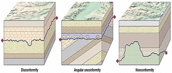
non conformity
younger sed rocks lie on top of older eroded igneous or metamorphic rocks

unconformity
gap in geological time where rocks have been eroded
angular unconformity
younger flat rocks lie on top of older tilted and eroded rocks

disconfomormity
younger sed rocks lie paralllel to older eroded rocks
Biostratigraphy
using fossils to age date sed rx
index fossil
a fossil that is used to age date a sed rx layer based on the eons that the fossil lived
Detrital Zircon Analysis
age dating sed rx with zircon minerals
Transgression and vs regression
Transgression and regression describe changes in the relationship between sea level and land, while "rise" and "fall" are more general terms for sea level changes. Transgression refers to a relative rise in sea level, causing the sea to advance over land. Regression, conversely, is a relative drop in sea level, where the sea retreats from land.
source rock
high in og matter
usually shale or coal
potential to generate oil
resevoir
a rock that holds hydrocarbons such as oil
seal
an imperable rock that prevents that hydrocarbons from escaping thus providing a seal
migration
the route hydrocarbons oil take as they move from source rock to a reservoir or trap
maturation
process in which og matter is transformed into oil
Seismic stratigraphy
using seismic data to interpret rock layers
geophone arrays
used to detect and record seismic waves
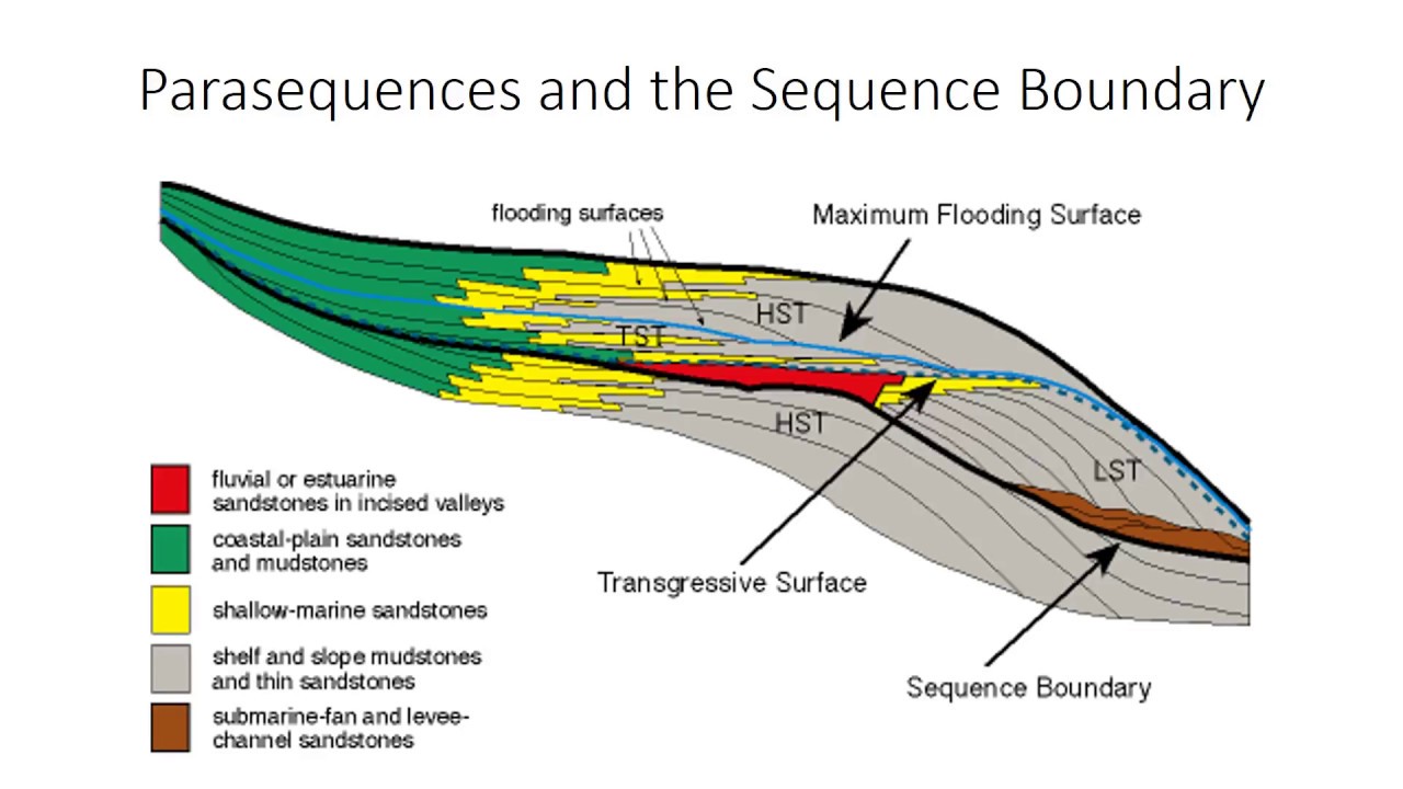
HST
(Highstand Systems Tract) refers to a geological sequence that forms during periods of rising sea level, characterized by the deposition of sediment in a marine environment.

TST
(Transgressive Systems Tract) represents a geological sequence formed during rising sea levels, where sediment is deposited in a regressive manner, typically transitioning from marine to terrestrial environments.

LST
(Lowstand Systems Tract) describes a geological sequence that occurs during falling sea levels, characterized by sediment deposition in terrestrial environments.

condensed section
is a stratigraphic unit representing a period of significant erosion or non-deposition that separates two sedimentary sequences, often indicating a change in depositional conditions. It typically reflects a hiatus in sedimentation.
hiatususes
periods of non-deposition in the geological record, where sediment is not deposited, resulting in gaps in the stratigraphic record.
parasequences
A succession of sedimentary layers that are deposited during conditions of relative sea level change, typically reflecting progradation and retrogradation.
maximum flodding surface
A boundary within a sedimentary sequence that represents the highest level of flooding during a transgressive event, indicating the change from land to marine conditions.

Sea level can vary locally/regionally via subsidence/uplift
Subsidence occurs when the land surface sinks, effectively raising the relative sea level. (fossil fuel extraction)
Uplift, or rising land, decreases the apparent sea level rise. (tectonics)
sea level rise (ocean temp)
Ocean Temperature:
Warmer ocean water expands, taking up more space and raising sea level. This thermal expansion is a significant contributor to sea level rise.
sea level rise (ground water volume)
Groundwater Volume:
Changes in the amount of water stored on land (e.g., in groundwater, lakes, and rivers) can affect sea level. For example, if groundwater is depleted and pumped into the ocean, sea level can rise.
sea level rise (continents)
Continental Togetherness:
The size and shape of ocean basins are influenced by the position and movement of continents. For instance, the breakup of supercontinents like Pangea has led to significant changes in ocean basin volume and shape, affecting sea level.
sea level rise (seafloor spreading)
Seafloor Spreading:
The rate at which new oceanic crust is formed at mid-ocean ridges influences sea level. When spreading is faster, the seafloor rises and can lead to higher sea levels. Conversely, a slower rate of spreading can cause sea levels to fall.
variation in sedimentation rate’s effect on chemo- and magnetostratigraphy
Variation in sedimentation rates significantly impacts both chemostratigraphy and magnetostratigraphy. Faster rates can lead to averaging out fine-scale chemical or magnetic signals, while slower rates can preserve more detailed records, but also make them more susceptible to post-depositional alteration.
toplap
Toplap, on the other hand, refers to the termination of a dipping bed against an overlying, relatively horizontal or less steeply dipping surface. It's as if the layer is "lapping onto" the top of another feature.

downlap
Downlap occurs when a dipping bed terminates against a less steeply dipping underlying surface. In simpler terms, it's like a layer of sediment "lapping down" onto a gently sloping surface.
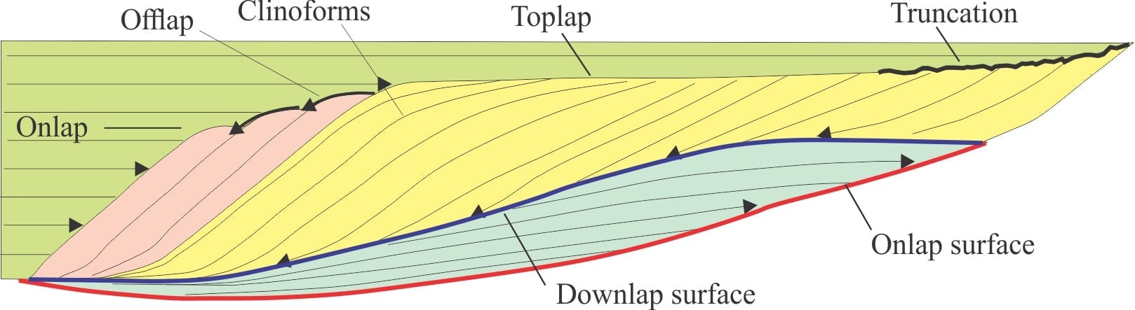
onlap
Onlap is the opposite of downlap. It describes the termination of a younger, generally shallowly dipping bed against a more steeply dipping, underlying surface. It's like the younger layer "lapping onto" the steeper surface.

sequence boundaries
Sequence boundaries are geological features that represent the transition between two distinct sedimentary sequences, typically indicating a significant change in depositional conditions, often associated with changes in sea level.