GPS/RNAV
1/57
There's no tags or description
Looks like no tags are added yet.
Name | Mastery | Learn | Test | Matching | Spaced |
|---|
No study sessions yet.
58 Terms
What is RNAV?
Allows navigation on a desired path without the need to overfly ground based facilities
What is GPS
GPS is a satellite based radio navigation system that sends a signal used by recievers to determine position anywhere in the world by tracking multiple satellites and using psuedo ranging.
GPS is a Global navigation satellite system satellite GNSS that is operated by the United States
Around the world their are other kinds of GPS but they are all considered GNSS
What are the types of RNAV?
Global navigation satellite system (GPS)
VOR/DME RNAV
DME/DME RNAV
Determing your point from a station by knowing distance/direction
Inertial reference system
What are the published RNAV routes?
Q routes - FL180 to FL450
T routes - 1200ft to 18,000ft
These routes are designated as RNAV 2 unless charted as RNAV 1
MRB - Magnetic reference bearing - The bearing between two waypoints on an RNAV route that should be seen on compass, MRB is magnetic, for situational awareness only, as the GPS is flying the true course between the way points
What is the difference between RNAV 1/RNP 1 and RNAV 2/RNP 2
RNAV 1/RNP 1 - Aircraft must maintain a total system error of not more than 1NM 95% of the time
RNAV 1 is found on SIDs and STARs
RNAV 2/RNP 2 - Aircraft must maintain a total system error of not more than 2NM 95% of the time
RNAV 2 is found on T routes and Q routes
Maintain RNAV centerlines unless
Unless otherwise authorized by ATC for deviation
In an emergency
What is a flyover and flyby waypoints
Fly over - Turn at the waypoint
Flyby - Turn before the waypoint or turn to the next course prior to reaching the waypoint seperating two route segments
What is PBN
Performance based navigation
General basis for navigation equipment standards in terms of accuracy, integrity, availability that changes based on the phase of flight
A certain accuracy must be met to comply with PBN accuracy requirements at lest 95% of the flight time
What is RNP
A set of standards for an Area Navigation (RNAV) system like a GPS to have certain navigation performance requirements within an airspace, AND the requirment for onboard performance monitoring to alert you when the navigatoin performance isnt being met (like by using RAIM or WAAS)
All RNAV approaches are RNP approaches
RNAV (GPS) - Title of most RNAV approaches in the US
RNAV (RNP) - Requires special FAA approval for the crew, aircraft, and operatoin
What are some examples of RNP levels?
Distances from the centerline of a flight path that must be maintained for aircraft and obstacle seperation
Enroute - RNP 2.0 (2NM accuracy 95% of the flight time)
Terminal & Departure - RNP 1.0 (1NM accuracy 95% of the flight time)
Final approach - RNP 0.3 (0.3NM accuracy 95% of the flight time)
What TSO apply to GPS navigation equitment?
TSO C145 or C146 (WAAS) - Standalone unit means you don’t need navigation equipment in your aircraft for VORs, NDBs, DME
TSO C129 or C196 (non-WAAS) - Not standalone means you need other navigation equipment, and the stations must be operational
Most IFR approved GPS meet RNAV 1 and RNAV 2 Requirments. To determine this check the GPS flight manual supplement
RNAV 1 - Accurate within 1NM 95% of the time
RNAV 2 - Accurate within 2NM 95% of the time
What are the different types of GPS approaches (DA)
LPV (DA) approaches increase in sensitivty after the FAF
Vertical guidance comes from a glidepath, use the lateral guidance from the GPS
WAAS
LNAV/VNAV (DA) approach has the same sensitivity after the FAF
Vertical guidance comes from something external to the GPS like altimeter, use the lateral guidance from the GPS
WAAS or GPS with baro VNAV
What are the types of GPS approaches (MDA)
LNAV (MDA) -
Fly the stepdown fixes and use the lateral guidance from GPS
WAAS, GPS with baro VNAV, Non-WAAS GPS
LP (MDA) - approach increases in sensitivity after FAF but doesnt have a glidepath
Fly the stepdown fixes and use the lateral guidance from the GPS
WAAS
LNAV+V (MDA) - NOT AN OFFICIAL TYPE OF GPS APPROACH
Vertical guidance comes from an glidepath for advisory purposes only
Many airport have GPS approaches that don’t have LPV mins, you are still flying an LNAV approach so use LNAV
WAAS
What is LNAV + V minima?
Advisory vertical guidance that is provided by some GPS recievers with LP and LNAV minima
The receiver will create a glidepath that assits in a constant descent to the MDA
When flying with an advisory glidepath you must ensure compliance to the stepdown fixes via the altimeter
How can you determine which minima you can descend to?
The GPS will indicate which level of minima can be used
What is the reasoning for publishing LP minima
LP minima is only published if obstcales prevent the addition of vertical guidance for an LPV approach
What should occur 2NM before the FAF on your GPS
The GPS should go from TERM mode to APR mode (sensitivity increases)
The reciever performs a RAIM prediction 2NM prior to ensure RAIM will be avaliable at the FAWP as a condition to enter approach mode
What should you do if the GPS reciecer fails to go into approach mode before the FAF or your lose RAIM during the approach?
Without RAIM the pilot has no assurance as to the accuarcy of the GPS so you should execute the missed approach and advise ATC
If a RAIM alert appears can you navigate via the GPS?
Without RAIM the pilot has no assurance as to the accuarcy of the GPS
Navigation information should be considered advisory only
Refer to the flight manual supplement for operating information during RAIM alert
If you lose the capability for a WAAS approach (vertical flag off appears) can you continue flying with LNAV minima?
Yes, provided that the lateral navigation is still within integrity limits
How can you determine what line of GPS approach minima you can use?
Flight manual supplement
What is the satellite consillation?
The satellite constillation is 24 geosynchronous satellites
6 different orbital planes
4 satellites per plane with room for a spare
30 satellites max
Orbits above the Earth at 10,900NM
At any point on the globle…
5 sats are always visible anywhere on Earth, but typically 6-8
Reciever uses a minimum of four sats above the mask angle which is the lowest angle above the horizon at which it can use a satellite
What does the term geosynchronous mean?
All move with the Earth’s rotation and the orbital period is half a day or 11 hours and 58 minutes
How are sats oriented?
They are oriented so solar panels face sun and anetnnas face Earth
What are the components of sats?
Solar panels
Antennas
Atomic clock
Radio transmitter
Pseudorange
Distance between sat/receiver including path delays
Calculated based on time it takes for signal to travel from sat to receiver
What are the components of the ground control network?
Master control station
Monitor station
Ground based antenna
Master control station
Makes commands that control the satellite constellation
Performs MX
Anomaly resolution by repositioning satellites
Monitor station
Collects data from satellites in constellation
Pseudorange measurements are made to each satellite in view and are used to update the MCS estimate of each sats position in orbit
Sends data to MCS, 16 around the globle
Ground based antenna
Sends commands and navigation data, uploads to the sats
11 around the globe
4 GPS antenna
User equitment
Processes L band signals from sats for computation of position, velocity, time
Examples of user equitment is the GPS reciever
Trilateration
Essentially the system works by creating a bubble around the satellites that is the psuedo range and the location of the intersection of those bubbles is where you are. With just one sat it knows the distance you are from the sat but not which point on the bubble
Reciever uses trilateration between 3 sats to determine 2D position (lat and long)
4 sats are used to determine 3D position (lat long and altitude), 4 sat gives altitude
How does the GPS compute information like speed and course?
By looking at the position changes as the intersection of the bubbles changes
What can the reciever give you?
Where you are
Where you are going
How long you’ve been traveling
How fast you’re going (ground speed)
ETA
GPS Operation
Sats constantly emit a signal to receivers
Location determined in time when signal was sent and recieved
Each sat and receiver has atomic clock, time information from sat is transmitted to the receiver.
Receiver compiles data to get distance.
How do GPS units navigate?
Great circle navigation - They determine the shortest distance between two points on a sphere
GPS CDI deflection shows distance off course in NM vs VOR CDI which should angular distance off course in degrees
GPS can substitute ADF or DME as long as GPS can be used in an NDB approach with the precense of “Or GPS in the title”
RAIM
A function of GPS receivers that adequate GPS signals are being received at all times. Without RAIM you have no assurance to the accuracy of the signal from the sats
RAIM (fault detection) requires 5 sats or 4 with baro aiding reciever
RAIM (fault exclusion) to remove a corrupt signal requires 6 sats or 5 with baro aiding
When is a RAIM error message given?
When the reciever determines that the GPS signals do not meet the criteria for safe NAV use for:
Sat position
Atomic clock malfunction
Not enough sats to compute RAIM
When is a RAIM check required?
Non WAAS GPS - RAIM does need to be avaliable for the route and time of flight
WAAS GPS - RAIM does not need to be avaliable as long as WAAS coverage is avalaible for the route of flight. If going outside the US (no WAAS) then check RAIM
RAIM unavaliable for more than ___ minutes should cause the flight to be rerouted or done without RAIM
5
What are the types of GPS Augmentation systems?
GPS augmentation system - Improves accuarcy of GPS by recieving error from reference stations and broadcasting the errors to supported GPS receivers
SBAS - The parent system of WAAS (known as WAAS in the US)
WAAS covers a wide area
GBAS - Also like WAAS but errors are broadcasted via VHF to GBAS enabled recievers
Ground based augmentation system formally LAAS (local area)
GBAS is more accurate than WAAS but covers a much smaller geographical area
Allows for Cat I and above approaches to GLS DA minima
WAAS (fault detection w/correction)
WAAS improves accuracy, integrity, and availability of GPS signals
WAAS improves accuracy by determining errors from GPS satellites via ground based reference stations
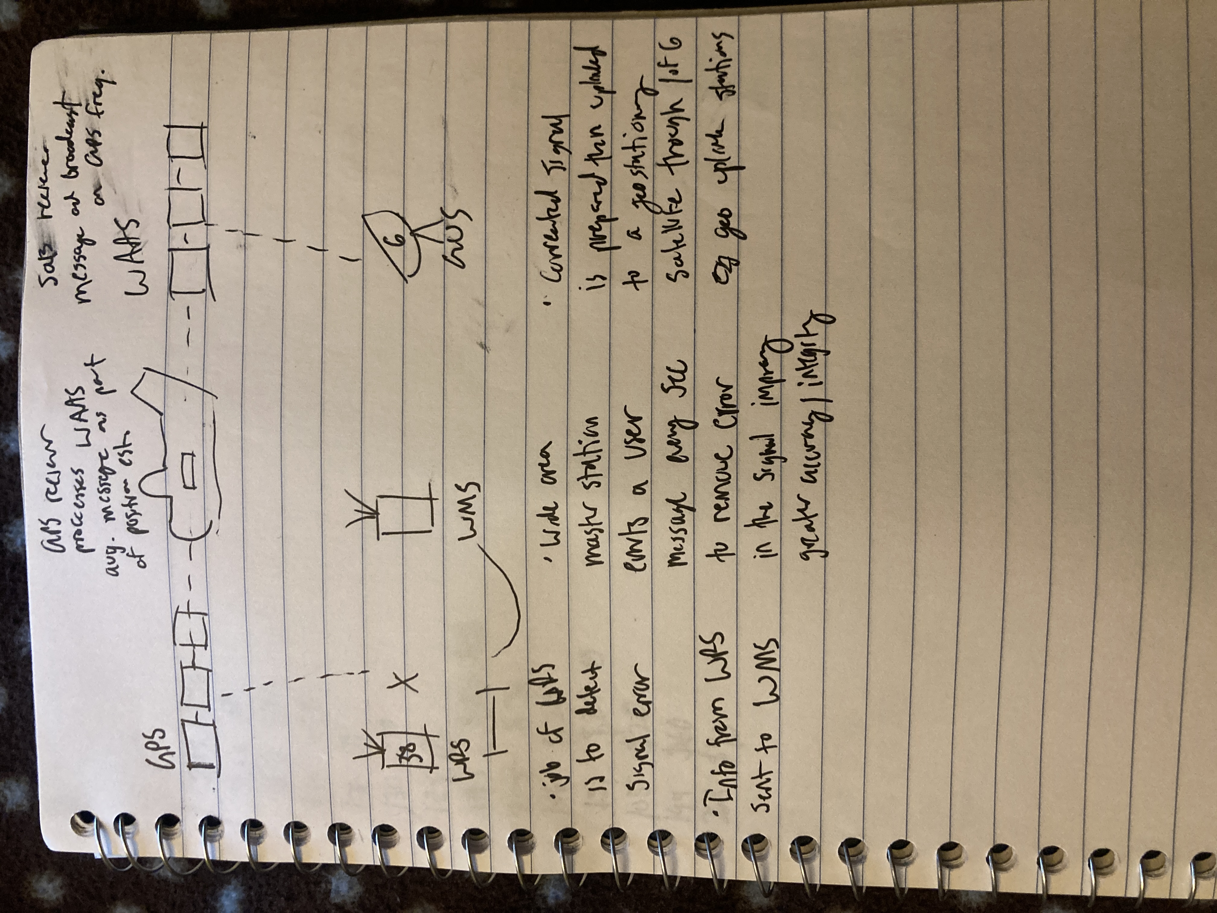
Learn this WAAS diagram
Learn this WAAS diagram

What are the components of WAAS?
Geosynchronous sats (sat constellation)
Geostationary sats (3)
Wide area reference stations (38 total)
Wide area master stations (3)
Geo uplink station (6)
WAAS GPS reciever (in a/c)
What is the reason for the biggest errors in signals?
Ionosphere delay is the reason for the biggest error in signals and is caused by the atmosphere altering the speed and direction of signal
What are some of the benefits of WAAS?
Improved accuracy and integrity of the signal
More extensive service area
Lower minimums for GPS approaches
LP/LPV approaches for WAAS
LNAV/VNAV approaches for RAIM
No need to check RAIM (unless issued to NOTAM)
Flight applicability of GPS
M - Manual for GPS onboard (required by manufacter)
S - Status of VORs for backup
A - Have an approved GPS receiver (WAAS or non WAAS)
If using GPS as primary means of NAV
Non WAAS receiver means you need another form of navigation
N - Check GPS NOTAMs before flight and use the RAIM prediction if avaliable on your reciever
D - Current GPS database (28 days)
Verify waypoints are correct as on low enroute chart
S - Be familiar with GPS sensitivites
Departure and DPs (Terminal mode)
±1NM
More than 30NM from airport (Enroute mode)
Non WAAS ± 5NM
WAAS ± 2NN
Within 30NM (Terminal mode)
± 1 NM
Just before FAF (Approach mode)
± 1NM to ± 0.3 NM
(LPV ONLY) At Threshold
± 350ft
What is OBS or non sequencing mode
Navigation mode that doesn’t make a line between waypoints and instead allows the pilot to select desired track a line to or from the waypoint
What is baroaiding?
Augment the GPS integrity solution by using a non satellite source(aircraft static system) to provide vertical reference
Use the current altimeter setting
Used in lieu of 5th satellite for RAIM
Can you follow GPS altitude
No because the vertical error can be quite large and no integrity is provided
What are the methods used to check RAIM
FSS - Request GPS NOTAMs, Provides RAIM information for 1 hour before and after ETA unless you request later time
SAPT - On FAA website
Reciever - Use the recievers RAIM prediction tool
GPS service dispruptions can also be found on notam.aim.faa.gov
What are the different GPS databases and when are they required to be used?
28 days - Navigation database
56 days - Obstacles database
As needed - Terrain and airport map
What database is required for IFR flight?
Navigation database must be current for approaches
Some units allow for IFR enroute with an expired database if you can verfy waypoints with low enroute chart
Can you update a database and does it have to be logged
Yes as long as no special tools are used and it does not have to be logged
How can you determine what kinds of operations and limitaiotns are avaliable for your GPS
Flight manual supplement
What is meant by the terms “UNRELIABLE” and “MAY NOT BE AVALIABLE” in GPS NOTAMs
These are indications that the expected level of service might not be avaliable
UNRELIABLE - If GPS service is avaliable you can conitnue operatoins and provided LNAV or LNAV/VNAV is avaliable fly the approach
MAY NOT BE AVALIABLE - Details that the expected level of WAAS service (LPV or LP) may not be avaliable
What is meant by the W in a black square on RNAV approach plates
WAAS UNRELIABLE and air traffic advisories are not provided for loss of LPV and LNAV/VNAV vertical service
This is due to the airport being at the edge of WAAS serivce
If you get there and it says LPV or LNAV/VNAV is avaliable you can use those minima