Geography coasts
1/15
There's no tags or description
Looks like no tags are added yet.
Name | Mastery | Learn | Test | Matching | Spaced |
|---|
No study sessions yet.
16 Terms
system definition and elements:
a group of interrelated processes that operate simultaneously in the physical landscape
a system contains elements of:
a functioning set of components
a flow of energy which powers said components
a process for internal regulating known as feedback
what makes up a system:
inputs - matter is added to the system
outputs - matter is removed from the system
stores - the accumulation of matter in a space
flows - the movement of matter
boundaries - edges of systems
key coastal system attributes:
processes - marine, terrestrial, atmospheric and biological mechanisms which move material between stores
controls - the given of the coastal environment - climate, geology, rock structure, sea level, all subject to change
landscape components - physical features of erosion and deposition that are shaped by systems but may also contribute to inputs and receive outputs
dynamic equilibrium
when the system is in a steady state, where it is not growing or reducing so it is balanced - inputs = outputs
feedback loops
where processea are not in balance so either an increase or decrease
negative - the chnage is not amplified e.g. cliff erosion causing slumping, reducing cliff retreat
positive - the change amplifies the change in cycle e.g.erosion wears limestone, adds more rocks to sea, more rocks thrown at cliff
difference between landform and landscape
land form - a natural feature of the earth’s surface
landscape - ALL the visable features of an area of land, often a areas aesthetic appeal
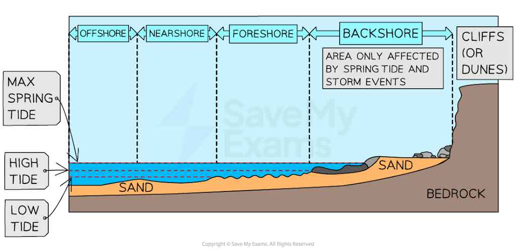
define each shore zone
breaker zone - where waves break at the coast due to increased friction with the seabed, slowing and shortening wavelength
nearshore zone - the area of shallow water beyond the low tide mark where waves first interact with the seabed, causing them to steepen, break and reform while surging to the beach
swash zone - the area where incoming broken waves rush up as the ‘swash’ which is the land-ocean boundary where the water mark fluxuates often
offshore zone - the zone going seaward from the point of low tide to the depth of the wave base level or to the outer edge of the continental shelf
foreshore - the internal zone of the coast defined with high tide
back shore - often dry area which is only affected during large storm events
the formation of waves:
wind transfers it’s energy to the surface of the sea
this causes frictional drag which disturbs the surface, forming ripples
if on open sea, there is little horizontal movement of water, rather an orbital motion, causing oscillatory waves
near to the coast, horizontal movement of water does occur as waves are driven onshore, known as translatory waves
less shallow water means waves become more epiletical as friction acts on the water
the wavelength and the velocity decreases where the wave height increases
causing water to back up behind and rise to the point where it topples over
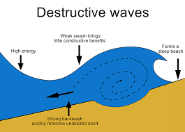
destrucive waves
high energy
strong backwash, removing undesired sand
weak swash brings it further in shore
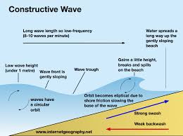
constructive wave
low energy, meaning lower wave frequency
strong wash carries strong constructive elements
weak backwash takes time to remove sand
forms a wide sloping beach
Fetch definition
the distance of open water over which the wind blows uninterrupted in a single direction, creating waves
tides
tides are caused by the effect of gravity from the moon and (less so) the sun acting on the earth.
one ocean bulge is expected on the side of the earth facing the moon, with
another one on the other size of the earth at the same time, between them on the sides, the sea is lower, creating low-tide
high tides happen approximately twice a day, for the sun and the moon
this effect is strongest when the earth and the moon are in line with earth, this happens when there is a full moon and new moon
tidal ranger and intertidal zone
tidal range - the vertical difference in height of sea level between high and low tide. it varies with the monthly lunar cycle and is at its maximum with spring tide conditions
intertidal zone - the shoreline between the highest and lowest spring tides; it is where the predominant wave activity occurs so is subject to most marine erosion transfers and deposition
high energy coast
a coastline subject to maximum inputs, likely to be dynamic
strong coast with strong waves
long fetch
winds that approach from a consisten onshore direction
low pressure
large tidal range
many inputs of energy sources
erosion and transpiration common
low energy coast
a coastline that has key inputs, transfers and outputs in balance and is more likely to be in a state of stable equilibrium
less poweful / no waves
short fetch
varied wind direction or offshore winds
less extreme air pressure gradients
gentle tidal range
few inputs of energy
deposition