Geography: Section C (Glaciation)
1/73
Earn XP
Description and Tags
Made by Habeeb. Section C (Coasts) of Mrs Speed's painful revision sheet into this flashcard set 💀. Revise this set to get a 9 🥳😁
Name | Mastery | Learn | Test | Matching | Spaced |
|---|
No study sessions yet.
74 Terms
What is a glacial period/ice age?
Cold period where global temperatures decrease and ice advances
What is an interglacial period?
Warm period when temperatures increase and ice retreats - we are currently in one
During the last ice age in the UK, how far south did the ice sheets stretch?
As far south as Cardiff
During the last ice age in the UK, what areas were covered in ice sheets hundreds of metres thick?
Scotland
Most Wales
Northern England
What is a glacier?
Slow moving river of ice formed from compacted snow
What is an ice sheet?
Large mass of ice over 50,000km2
What are ice caps?
Smaller masses of ice less than 50,000km2
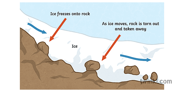
What is plucking?
When part of the bedrock freezes to the glacier, and as the glacier moves, rocks are plucked out of the bedrock
Explain the process of freeze thaw weathering
Water enters cracks, freezes below 0°C, expands by 10%, and puts pressure on surrounding rocks. Thawing during the day and repeated freezing cause pieces of rock to break off (scree).
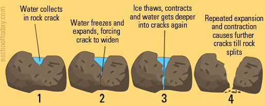
What is scree?
Pile of loose rocks at the bottom of a slope or cliff
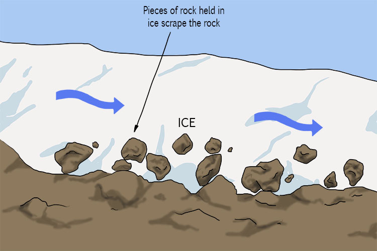
How does abrasion (in terms of glaciation) occur?
When rocks embedded in a glacier (due to freeze-thaw weathering and plucking) scratch and rub against the bedrock, leaving a flat surface and striations that show the glacier’s movement direction.
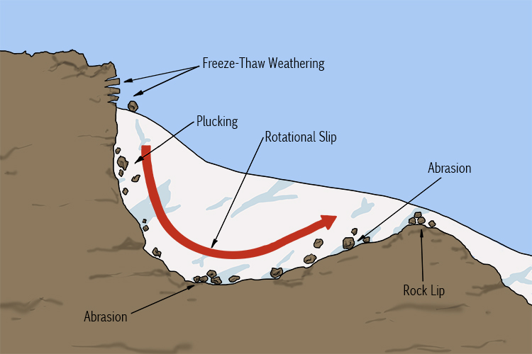
How does rotational slip (in terms of glaciation) occur?
When a glacier, lubricated by meltwater, slides downhill along a curve
What is bulldozing (in terms of glaciation)?
When material of all sizes is transported as the glacier pushes its way through the landscape
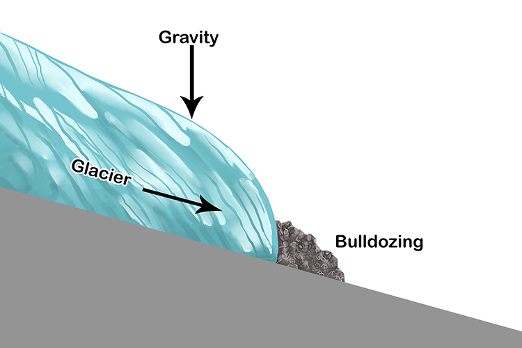

How can material be carried during bulldozing (in terms of glaciation)?
Can be carried:
Englacially (within the glacier)
Subglacially (under the galcier)
Supraglacially (on top of the glacier)
When does deposition of the weathered and eroded material occur (in terms of glaciation)?
During glacial melting or retreat
At what part of a glacier does deposition usually occur?
At the snout, where temperatures are warmer or where there is friction between the glacier and the valley sides
What does a retreating glacier deposit?
Unsorted glacial till, containing rocks of different size and angularity
Meltwater carries deposited material further down the valley as an…
Outwash plain
What are the deposits like in an outwash plain?
They are rounded by fluvial processes and sorted and stratified by size, with the largest being deposited first
What does glacial erosion lead to?
Formation of distinct landform in upland areas

How do pyramidal peaks (like the Matterhorn) form?
Form when 3 or more corries form mountain sides and erode backwards, leaving a single peak which is triangular in shape

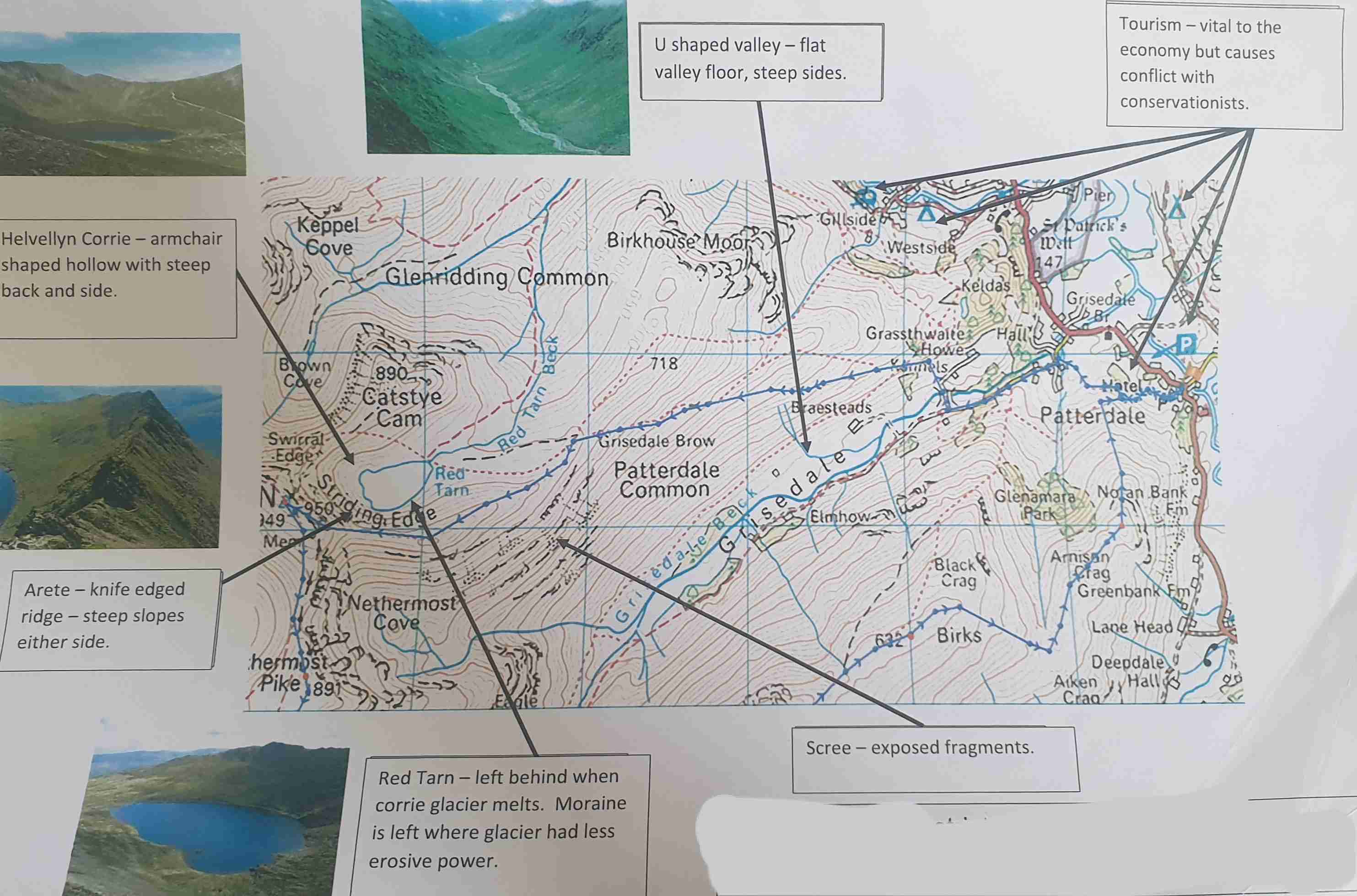
How do Aretes (like Striding Edge in the Lake District) form?
Form when 2 corries erode back to back, causing the land in between to become narrower

How do hanging valleys form?
Form when a smaller tributary glacier erodes more slowly than the main glacier. When glacier melts, this valley is left hanging above the main valley
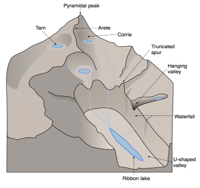
How do truncated spurs form?
Form when a glacier cuts through interlocking spurs

How do glacial troughs/U-shaped valleys form?
Form when a glacier cuts through a former V shaped valley, creating a flat bottomed, steep-sided valley

How do ribbon lakes form?
Form when a glacier flows over softer rock in glacial troughs. The soft rock erodes to a greater depth, and when the glacier melts, water collects in the deepened area, forming a lake.
Where does the lateral moraine form?
At the sides of glaciers due to freeze-thaw weathering
Where does ground moraine form?
On the floor of glacial troughs
Where does recessional moraine form?
Behind the terminal moraine
Where does the medial moraine form?
In the middle of a glacier where 2 lateral moraines meet
Where does terminal moraine form?
At the snout of the glacier
What does a terminal moraine show?
The extent of glacial advance
How do drumlins form?
Form when a glacier advances and retreats, shaping ground moraine into small, egg-shaped hills
What are erratics?
Boulders that appear out of place compared with their surroundings
Why are erratics out of place compared with their surroundings?
They are left behind after being transported and deposited by a glacier
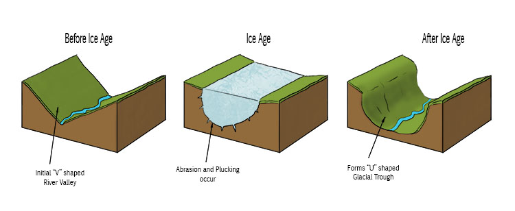
Explain the process of how glacial troughs/U shaped valleys are formed
Firstly, a glacier occupies a v shaped valley because the environment becomes glaciated
Then, plucking occurs on valley sides and bottoms because meltwater freezes to the rocks below the glacier and plucks pieces of rock away as it moves.
Next, valley floor is widened because abrasion scours the rock, partly due to the sheer weight of the glacier and partly by rocks carried subglacially.
Finally, a U shaped valley is formed with steep sides and a wide, flat valley bottom, which often contains a ribbon lake once glacier has melted
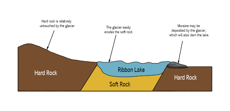
Explain the process of how ribbon lakes are formed
Firstly, glacier erodes a glacial trough through plucking and abrasion
Then, plucking occurs on the valley sides and bottom because meltwater freezes to the rocks below the glacier and plucks pieces of rock away as it moves
Next, some areas of the valley floor are eroded more because the ice is thicker after 2 glaciers join together or because there are areas of less resistant rock
Finally, when the glacier melts, it leaves behind ribbon lakes, which are often tens of meters deep
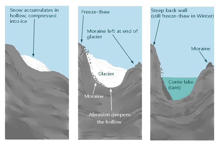
Explain the process of how corries are formed
Firstly, snow accumulates in a hollow on a north facing hollow, which gets deeper and compresses to become a corrie glacier
Then, freeze-thaw weathering occurs above the glacier, which helps to enlarge the hollow
Next, plucking steepens the backwall and rotational slip abrades the bottom of the corrie, which deepens the hollow
Finally, a raised lip is formed because the ice is thinner, and the rate of erosion is reduced. A tarn might form in the over deepened hollow when the corrie glacier melts

Explain the process of how truncated spurs are formed
Firstly, a glacier occupies a former V shaped valley and begins to erode the valley sides and floor through plucking and abrasion
Then, when it reaches interlocking spurs, the glacier bulldozes through them, leaving steep-edged truncated spurs on the valley sides
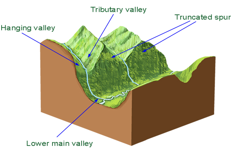
Explain the process of how hanging valleys are formed
Firstly, smaller glaciers occupy tributary valleys above the main glacial trough
Then, because the rate of erosion is less, these valleys are not eroded down to the same level as the main glacier
Finally, these valleys are left hanging above the glacial trough and often have waterfalls flowing out from them
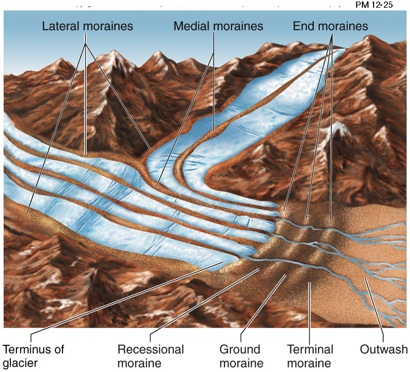
Explain the process of how moraine is formed
Firstly, glaciers transport eroded and weathered material subglacially, englacially and supraglacially, which is deposited in various ways
Then, lateral moraine is deposited on the valley sides as it is made up of material carried on top of the glacier from freeze-thaw weathering
Next, where 2 glaciers meet, 2 lateral moraines join together to become medial moraine which is found on the surface in the middle of the glacier
Then, terminal moraine is formed across a U shaped valley, marking the maximum advance of the glacier
Finally, ground moraine is formed from the material carried under the glacier due to the ice melting and covers the valley floor
What are drumlins?
Elongated hills of glacial deposits
What is a group of drumlins called?
drumlin swarm or basket of eggs
How do drumlin swarms form?
Form when glaciers deposit sediment in streamlined, elongated hills as they move over the landscape
When would the glacier deposit drumlins?
When it is overloaded with sediment
What does the long axis of the drumlin indicate?
The direction in which the glacier was moving:
Steep side shows where it was flowing from
Gentle slope shows where it was flowing to
What are the sizes of erratics?
Range from pebbles to large boulders
What can erratics indicate?
The direction of ice movement
What is the lake district?
Glaciated area in the UK located North-West of England
What is the aim of the lake district?
To conserve and enhance the natural beauty, wildlife and cultural heritage of the areas whilst looking after the economic and social well-being of local communities
What is a honeypot site?
Location that attracts a large number of tourists. This can put pressure on the local environment and people
Does the lake district contain honeypot sites?
It contains many honeypot sites
What are the features of glaciation in the lake district?
Striding Edge - Arrete
Swindale - Drumlins
Blea water - Tarn, Corrie, Moraine
Wastwater - Ribbon lake
Great Gabel - Pyramidal peak
Ennerdale - Erratics
What are the economic uses of the lake district?
Farming
Forestry
Quarrying
What are the benefits of quarrying, farming, and forestry in the lake district?
Creates jobs
Creates income
Boosts local economies
What is quarrying?
Process of extracting rock, sand, gravel, or other minerals from the ground
What are the negatives of quarrying in the lake district?
Can damage the natural environments
Destroys habitats
Makes the landscape unattractive
Lorries can cause damage to grass verges and create air pollution
What are the negatives of forestry in the lake district?
Involves conifer trees which are not native to the area
Fewer species planted, leads to a reduction in biodiversity
Zip wire can spoilt the peace of an area ans cause conflict with locals and other tourists
What are the negatives of farming in the lake district?
Disturbs habitats
Tourists use footpaths that cross farmland, occasionally leaving gates open through which animals can escape
Loose dogs can worry sheep
Some people leave litter, which can be dangerous to animals
What can conifer plantations do?
Obscure views and affect tourism
Why does quarrying cause conflict with the locals?
It’s noisy, messy and creates traffic congestion
What is the issue with using glacial environments for farming?
Fields will not be left as a wilderness
Tourism creates a need for second homes, why is this an issue?
Increases house prices
Causes footpath erosion in honeypot areas
Increases congestion
What are the benefits of tourism in the lake district?
15 million visitors each year, creating 15,000 jobs for local people
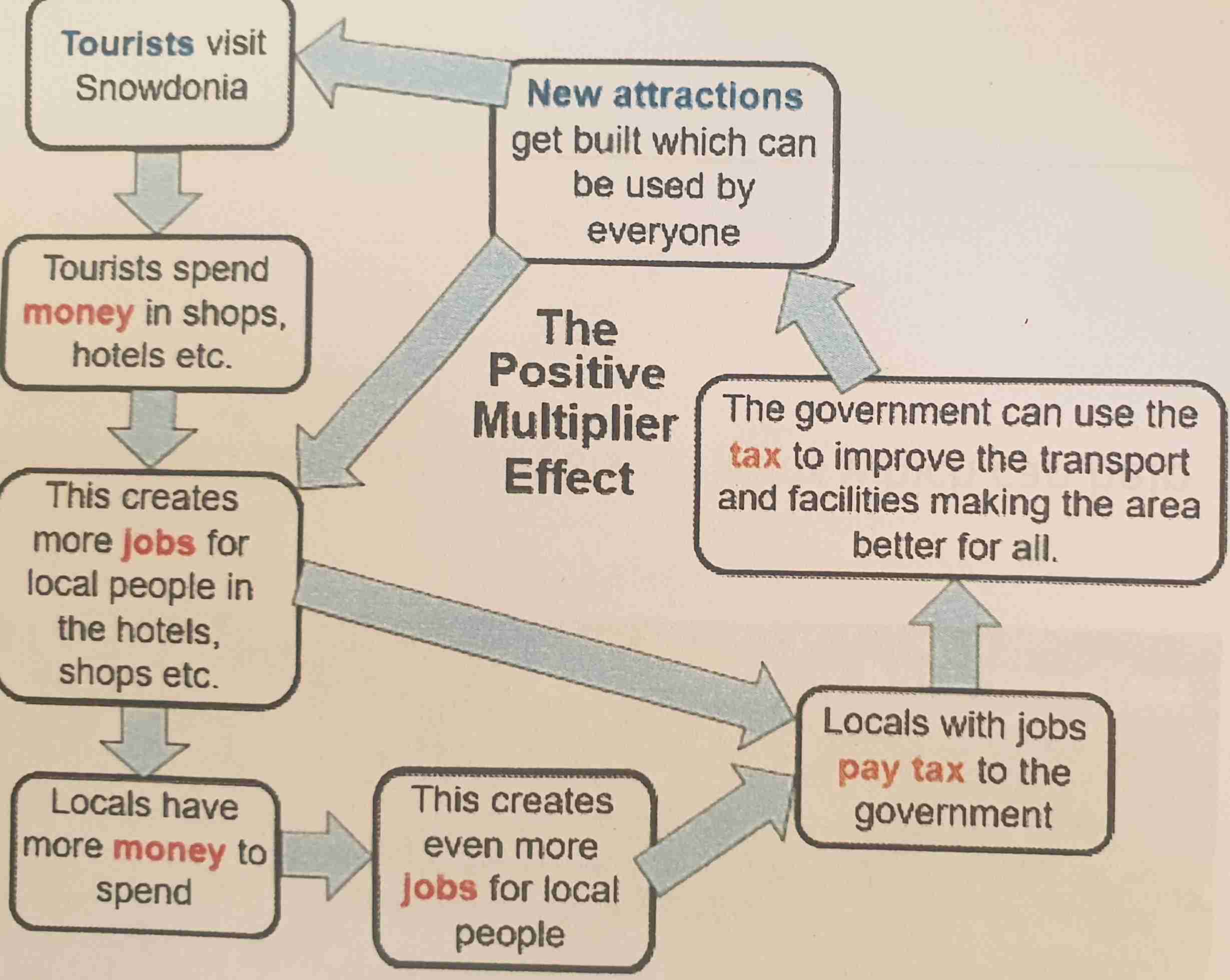
Tourists spend £1000 million each year in hotels, restaurants and shops, which boosts the local economy and can lead to the positive multiplier effect
Encourages growth of new businesses such as adventure tourism, which creates further jobs, particularly for young people
What are the negatives of tourism in the lake district?
90% arrive by car, causing congestion on many narrow roads and creating pollution, bad in honeypots site
Parking issues for local landowners makes access difficult
Water sports damage lakesides
Pollution from cars and waste increases
Show the image of the multiplier effect of tourism in the lake district
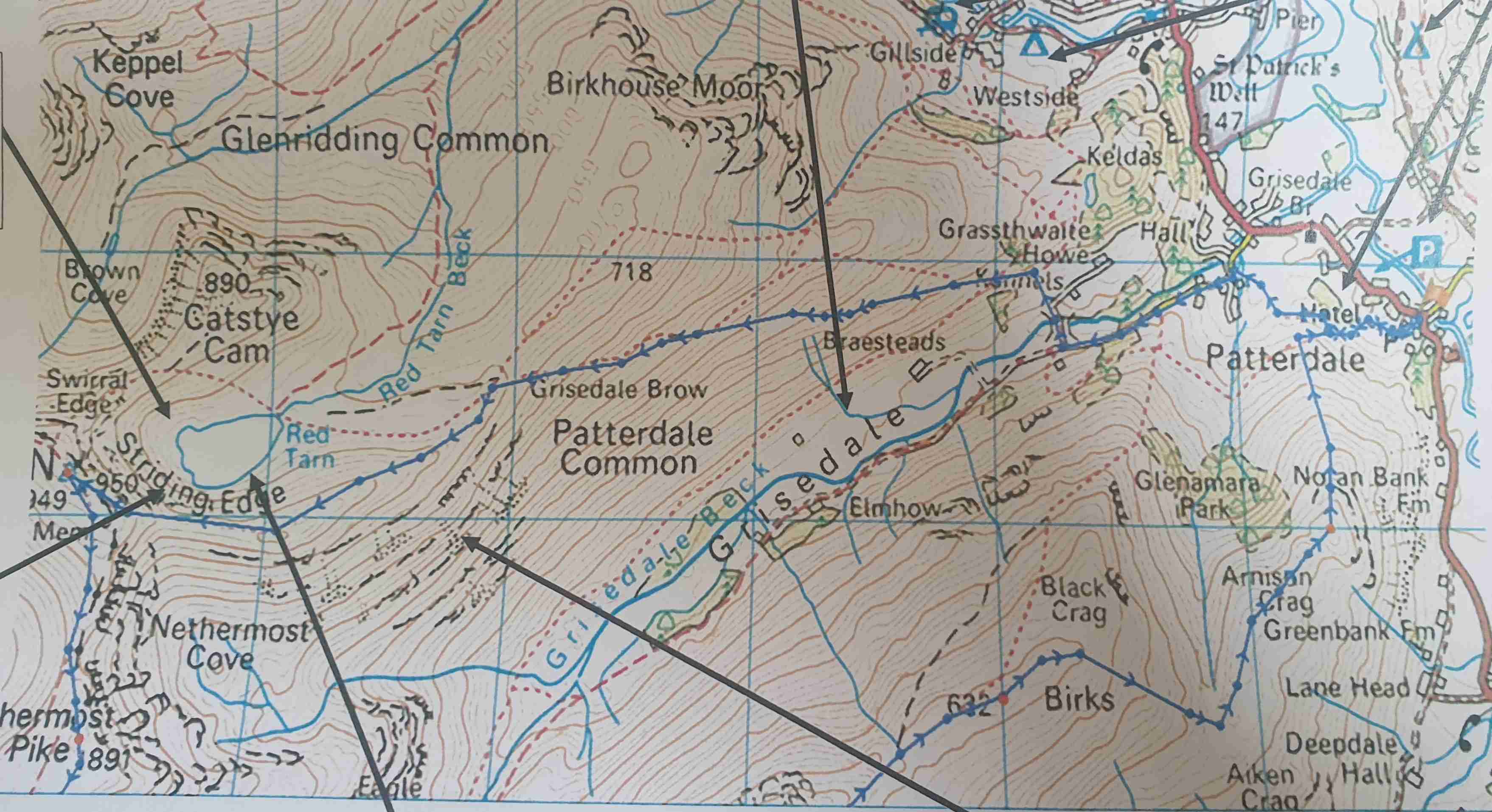
By looking at the OS map of the lake district, identify the glacial features
What are the traffic management strategies used in the lake district?
Public transport
Traffic calming measures used in villages to make roads safer
Restricted parking zones
Settlements such as Ambleside used as a transport hub
What are the environmental strategies used in the lake district?
Volunteer groups
Native species replanted alongside those able to withstand erosion
Improved signage to keep people on paths
Hardy species planted, able to withstand trampling
How does the “country side code” help the lake district?
Educates tourists about closing gates and keeping animals on leads, which can help reduce impacts on farmers
Why are visitors encouraged to use buses instead of cars in the lake district?
Reduces congestion and air pollution
How have parking zones in the lake district been improved?
Car park on the edge of the village has been expanded
Parking on grass verges restricted
Parking near houses restricted
This reduces conflicts
Why are settlements in the lake district used as a transport hub a positive thing?
Takes the pressure off other villages and enables tourists to get around easily from site to site
What is “fix the fells”?
A volunteer group focused on repairing and maintaining upland paths in the lake district to prevent erosion and protect the natural landscape