EARTH SCIENCE 23-24
1/58
Earn XP
Description and Tags
Name | Mastery | Learn | Test | Matching | Spaced |
|---|
No study sessions yet.
59 Terms
Plate Tectonic Theory
A scientific theory that explains the Earth's lithosphere, the rigid outer layer, is divided into several large and small plates that float on the semi-fluid asthenosphere beneath them, constantly moving relative to one another.
Tectonic Plates
Massive slabs or solid rock that surround the Earth’s surface. Greek: tekton ‘carpenter/builder'
Earthquake
The result of sudden movement along faults within the Earth.
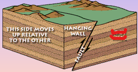
Faults
Are rock FRACTURES where a block of rock moves with respect to another caused by force.
Hanging Wall
For any fault except a perfectly vertical fault, the block above the fault plane
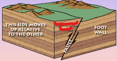
Footwall
The block below the plane
Faulting Geometry
Fault classification based on the geometry of faulting, which we describe by specifying three angular measurements: dip, strike, and slip.
Dip-Slip Movement
occurs when the hanging wall moved predominantly up or down relative to the footwall.
Dip
is the angle that describes the steepness of the fault surface.
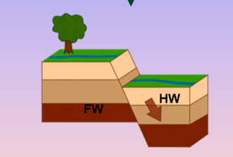
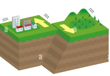
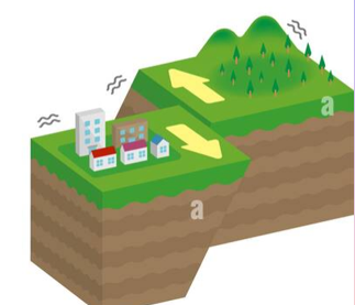
Normal Fault
If the motion was down. The hanging wall moves down relative to the footwall, in a way you would normally expect as a result of gravity. Form when rock is under tension, which is stress that stretches or pulls rock apart. They are common along divergent boundaries.
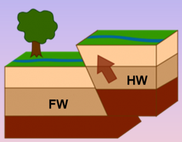
Reverse fault
The hanging wall moves up relative to the footwall. They form when rocks undergo compression, which is stress that squeezes or pushes rock together. They are are common along convergent boundaries, where two plates collide.
Strike Slip Movement
occurs when the hanging wall moves horizontally. The fault blocks move past each other horizontally. The faults form when rock is under shear stress, or stress that pushes rocks in parallel but opposite directions. They are common along transform boundaries, where tectonic plates move past each other.
Strike
is an angle used to specify the orientation of the fault and measured clockwise from north.
Right-Lateral Strike Slip Fault
Light- Lateral Strike Slip Fault
Oblique Slip
occurs when the hanging wall motion is neither dominantly vertical nor horizontal. Less common than the normal, reverse, and strike-slip movement
Active Fault
Areas along in which displacement is expected to occur. One that has moved in the past and is expected to move again. Considered to be geologic hazards. Has accumulated some displacement in the recent past. We can speculate it is very likely that the fault will be offset again in the future.
Inactive Fault
Areas that we can identify, but which do no have earthquakes. Judging a fault to be inactive can be tricky, but often we can measure the last time substantial offset occurred across a fault.
Tsunami
An ocean wave produced by underwater earthquakes or landslides.
Focus
Source of energy
Epicenter
Location directly above focus at the surface (ground motion is greatest)
Fault Trace
Shows intersection of Fault and the surface of the land
Fault Scarp
Indicates vertical motion of fault
Shallow Focus
Depths - 70km
Intermediate Focus
Depths - 70 to 300 km
Deep - Focus
Depths - 300 km
Filippo Cecchi
Italian physicist and priest who invented the first “true” seismograph in 1875.
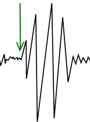
P wave

S Wave

Surface Wave
Typhoon
Most powerful manifestations of our planet's natural processes.
Typhoon Origin
Northwest Pacific Ocean
Habagat
South West Moonsoon. Winds come from the Southwest, have warm and moist air. They have moderate heavy rainfall during june to october
Amihan
Northeast Moonsoon . Winds come from the Northeast, they have cool and dry air. They have Slight to moderate Rainfall during november to May
Storm
counter-clockwise at the northern hemisphere and clockwise at the southern hemisphere
Cyclone
Origin: south pacific ocean and indian ocean. rotates in a different direction depending on which hemisphere it occurs, in the northern hemisphere it flows clockwise and at the southern hemisphere it flows counter clockwise
Coriolis Effect
which in turn occur because the earth is a rotation sphere.
Hurricane
Origin: Hurricane- North Atlantic, central and eastern north pacific
Air Mass
A LARGE BODY OF AIR WITH UNIFORM TEMPERATURE AND HUMIDITY
Low Pressure
Air Rises » Leads to clouds » leads to ___
High Pressure
Air Descends » No clouds » Sig
Signal No. 1
Wind Threat: OLD 30-60 km/h NEW 39-61 km/h
Warning Lead Time: 36 hrs
POTENTIAL IMPACTS:
• House of poor construction (e.g., wood frame, bamboo, makeshift), old dilapidated structures, and other structures made of light materials will suffer minimal to minor damage.
• Some banana and similar plants are tilted, while twigs of small trees may sway with the wind. Rice crops, especially those in flowering and ripening stages, may suffer some damage.
• Minimal disruption to public transportation.
Signal No. 2
WIND THREAT: 62-88 km/h (34-47 kt, 17.2-24.4 m/s)
WARNING LEAD TIME: 24 hours
POTENTIAL IMPACTS:
• Minor to moderate damage may occur to makeshift or old dilapidated structures, and other structures made of light materials. Houses of poor and average construction (e.g., unreinforced CHB/masonry, mixed timber-CHB) may receive minor roof damage.
• Unsecures, exposed lightweight items may become projectiles which may cause additional damage. Some electrical wires may be blown down, resulting in local power
outages.
• Minor to moderate disruption to public transportation.
• Most banana and similar plants are tilted, with some stooped or downed. Some small trees blow over, with twigs and branches of frail trees broken. Considerable damage is likely to rice and other similar crops, especially those in flowering and ripening stages.
Signal No. 3
WIND THREAT: 89-117 km/h (48-63 kt, 24.5-32.6 m/s)
WARNING LEAD TIME: 18 hours
POTENTIAL IMPACTS:
• Makeshift or old, dilapidated structures, and other structures made of light materials may suffer substantial damage. Houses of poor or average construction will have considerate roof damage, some blown-out windows, and/or partial wall damage. Well-constructed houses (e.g., reinforced/pre-cast CHB, reinforced concrete moment frame) may suffer minimal to minor roof damage.
• Warehouses and other buildings in industrial parks may suffer minor to
• Unsecured, exposed outdoor items of light to moderate weight may become projectiles, causing additional damage or injuries.
• Many areas may suffer power outages with numerous downed power lines ans posts. Minimal to minor disruption in telecommunications and potable water suppy.
• Moderate to significant disruption to public transportation
• Some small trees. most banana and similar plants, and a few large trees are downed or broken. Rice and other similar crops, especially those in flowering and ripening stages may suffer heavy damage.
Signal No. 4
WIND THREAT: 118-184 km/h (64-99 kt, 32.7-51.2 m/s)
WARNING LEAD TIME: 12 hours
POTENTIAL IMPACTS:
Severe damage will occur to makeshift or old, dilapidated light structures, and other structures made of light materials. Houses of poor or average construction may receive major damage, including complete roof failure and possible wall collapse; a few may suffer severe damage.
• Most well-constructed houses may suffer minor to moderate roof damage, with some houses experiencing major roof failure; blown-out windows are also likely.
• Failure of aluminum and steel roofs and coverings may occur in buildings at industrial parks.
• Some glass in most high-rise office buildings may be blown out; a few of these buildings may have minor to moderate damage and a higher proportion of blown-out windows due to swaying.
• Considerable airborne debris will be generated and may cause damage, injury, and possible fatalities.
• Near total loss of power supply and telecommunications due to numerous downed power lines, poles, and cellular towers. Diminished availability of potable water supply is also likely.
• Significant to severe disruption to public transportation.
• Significant damage to bananas and similar plants. Most small trees and some large trees will be broken, defoliated, or uprooted. Almost total damage to rice and other crops.
Signal No. 5
WIND THREAT: 185 km/h or higher (100 kt or higher, 51.3 m/s or higher)
WARNING LEAD TIME: 12 hours
POTENTIAL IMPACTS:
• Severe to catastrophic damage is expected to houses of poor or average construction, makeshift or old, dilapidated structures, and other structures made of light materials. Well-constructed houses may suffer substantial roof and wall failure or damage.
• Many industrial buildings will be destroyed, with only a few receiving partial roof and wall damage.
• Most windows will be blown out in high-rise office buildings; Moderate structural damage is possible due to swaying.
• Extensive damage will be caused by airborne debris. People, pets, and livestock exposed to the wind are at great risk of injury or death.
• Electricity, potable water supply, and telecommunications will be unavailable for prolonged periods due to significant disruption in infrastructure.
• Prolonged significant to severe disruption to public transportation.
• Vast majority of the trees will be broken, defoliated, or unrooted. Bananas and similar plants will be extensively damaged. Few trees, plants, and crops will survive.
PAGASA
- PHILIPPINE ATMOSPHERIC GEOPHYSICAL AND ASTRONOMICAL SERVICES ADMINISTRATION
Tropical Depression
61 km/h or less, wind signal 1
Tropical Storm
62-88 km/h, Wind signal 2
Severe Tropical Storm
89-117 km/h, wind signal 3
Typhoon
118-184 km/h, wind signal 4
Super Typhoon
185 km/h, wind signal 5
Q2- Which of the following is NOT a characteristic of a typhoon?
Extreme Cold Temp
Q2- What is the term used for a typhoon in the North Atlantic and Eastern Pacific Oceans?
Hurricane
Q2- What process is MOST enhanced by warm ocean water temperatures during typhoon formation?
Evaporation
Q2- Why do air masses form?
Large areas of Earth's surface share similar temperature and moisture characteristics
Q2- What seasons do the Philippines experience Habagat winds?
June to November
Q2- Why do winds generally blow outward from a high pressure system?
As air sinks and compresses, it spreads outward to areas of lower pressure