Air Masses
1/14
There's no tags or description
Looks like no tags are added yet.
Name | Mastery | Learn | Test | Matching | Spaced |
|---|
No study sessions yet.
15 Terms
Air Masses
● An air mass is a large body of air, usually 1 000 miles or more across, that has similar properties of temperature and moisture in the horizontal.
○ This means that along ANY horizontal layer at any given height, the properties of the mass will be uniform.
● The best source regions for air masses are large flat areas where air can be stagnant long enough to take on the characteristics of the surface below.
○ This also means that a high pressure area is going to be the best sort of area to create an air mass.
● The uniformity of temperature throughout an air mass means that the wind varies little with height
Air Masses-Source Regions
● The region in which an air mass forms is known as its Source Region.
● An air mass will take on the properties of the area in which it formed from stagnation of the air for a long period of time.
● For example, an air mass that forms in the high Arctic would be cold and dry, while one that forms over the Gulf of Mexico would be warm and moist.
● The Source Region of an air mass will always occur in an area of high pressure.
➢ Slow moving highs are the best at forming air masses.
● This is because in order to establish the uniformity of temperature and humidity the air mass needs to remain stationary or slow moving for a significant period of time.
➢ A week or two over a uniform area of the earth’s surface will generally do the trick in creating an air mass
Air Mass Weather
● Even though the moisture content and temperature are uniform in an air mass, this does not mean that it will be devoid of weather.
● The weather in an air mass will be determined by
➢ The moisture content
➢ The stability of the mass
➢ Any cooling or heating processes present
Air Masses-Classification
● Since the type or types (at a front) of air mass(es) will have a big effect on the weather, it is helpful to give them names.
● These names are dependant on the temperature and humidity of the air mass – which of course were determined by their source regions
● The first part of this name identifies the moisture content while the second part identifies the temperature.
● Moisture
➢ Continental = Dry
➢ Maritime = Moist
● Temperature
➢ Arctic = Cold
➢ Polar = Cool/Cold
➢ Tropical = Warm
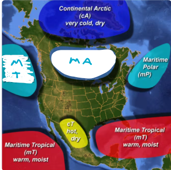
Common Air Masses in Canada
● In Canada, however, Continental Polar and Continental Tropical air masses are very rare.
● This results in the following air masses as being the common types in Canada from north to south:
➢ Continental Arctic (cA) - (winter)
➢ Maritime Arctic (mA) - (summer and winter)
➢ Maritime Polar (mP) - (summer and winter)
➢ Maritime Tropical (mT) - (summer)
Continental Arctic (cA)
● Cold and dry
● Originates north of the Arctic Circle
➢ Temperatures in the polar regions allow the air to cool to an often bone-chilling and record-breaking low temperatures.
➢ During the winter, Continental Arctic air often plunges southward over Canada and the USA.
● They rarely form during the summer, when nearly 24 hours of daylight is able to warm the Arctic.
Maritime Arctic (mA)
● Cold and moist.
● These Air masses usually form farther to the south of Continental Arctic air.
➢ They often dominate the Canadian weather picture during the winter, in particular along the coastal areas.
➢ During the summer these air masses will bring convection and showers to the interior of Canada.
● Surprisingly, during the summertime mA air can form over the Canadian North in locations that are far away from the ocean--ones that we might normally think of as being over the Continent!
➢ This is because there are lots of lakes in Northern Canada.
➢ These will thaw during the summer months, pumping the air mass full of moisture and warmth.
➢ This will cause it to become less stable
Maritime Polar (mP)
● Cool and moist
● Maritime polar air masses form over the northern Atlantic and the northern Pacific oceans.
➢ They usually bring cloudy damp weather to Canada.
➢ They most often influence the Pacific northwest and the Atlantic northeast.
➢ Maritime polar air masses can form anytime of the year and are usually not as cold as continental polar air masses.
➢ Present year-round, but more pronounced during spring and fall
Maritime Tropical (mT)
● Warm temperatures with copious moisture.
● Maritime tropical air masses are most common across eastern Canada and originate over the warm waters of the southern Atlantic Ocean and the Gulf of Mexico.
➢ These air masses can form year round, but they are most prevalent across Canada during summer.
➢ Maritime tropical air masses are responsible for the hot humid days of summer
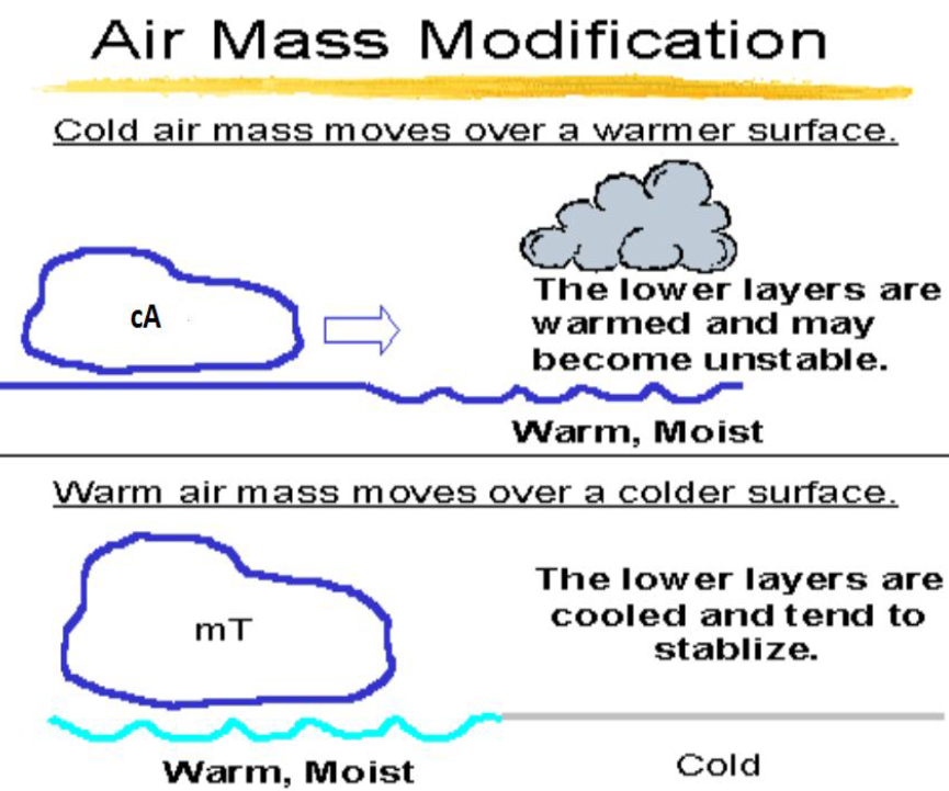
Modification
● Over time an air mass can move away from its source region.
➢ In this case, it will likely be modified by the area over which it passes
● This modification can be great enough to create a new type of air mass.
● The extent to which an air mass will be modified depends on:
➢ The speed at which it is moving;
➢ The moisture content of the area over which it is passing; and,
➢ The temperature difference between the air mass and the new region
Stable Air Mass Characteristics
● Poor low-level visibility.
● Layer type cloud.
● Steady precipitation.
● Steady winds which can change markedly with height.
● Smooth flying conditions
Unstable Air Mass Characteristics
● Good visibility (except in precipitation).
● Convective type cloud.
● Showery/intermittent precipitation.
● Gusty winds.
● Turbulence
Air Masses- Advanced Modification Topics
● Generally, as an air mass moves from the source region to a new region, notice and remember that it will be modified through either cooling from below or warming from below
● If an air mass is modified by warming from below--such as by solar radiation or passing over a warm surface--then instability and convection will result.
● This convection and instability will "mix in" to the higher levels of the atmosphere and lead to modifications at considerable heights.
➢ If the lapse rate is steep enough, this instability can extend to the tropopause.
➢ Weather charts might depict an air mass encountering this warming from below with an additional script of k, to show that it is colder than the surface below it.
➢ Example cAk
● If an air mass is modified by cooling from below, such as by passing over a cold surface, then an inversion will occur.
● This inversion will resist mixing and lead to modification only in the lowest levels of the air mass.
➢ Weather charts might depict an air mass encountering this with an additional script of w, to show that it is warmer than the surface below it.
➢ Example cTw
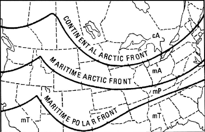
Air Masses- Frontal Boundaries
● When different air masses collide, the boundaries between the masses are known as fronts.
● You can learn more about fronts in the section called "Fronts and Frontal Weather"
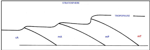
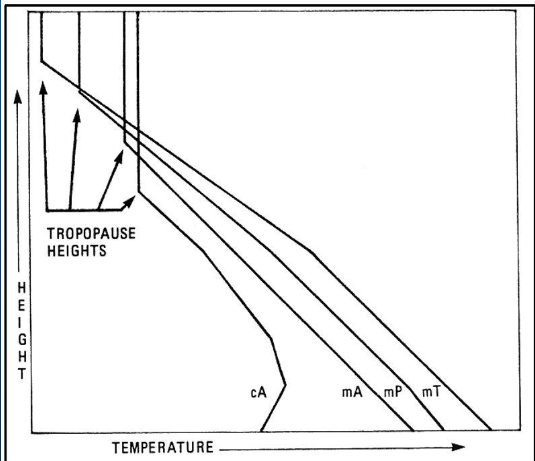
Air Masses- Heights and Temperatures
● A few more things to know about when it comes to air masses:
○ An air mass is ALWAYS topped by the troposphere.
○ The warmer an air mass is, the HIGHER it will cause the level of the tropopause to be.
○ This also means that at the tropopause the temperature of the WARMEST air masses (such as mT and mP) will be COLDER than an air mass that is generally cooler (such as mA and cA).
○ Initially, it seems to defy logic, but the temperature vs. height diagram in the next slide will show this, as well as a glance at the constant pressure charts