MEA 422 Final Exam
1/50
There's no tags or description
Looks like no tags are added yet.
Name | Mastery | Learn | Test | Matching | Spaced | Call with Kai |
|---|
No analytics yet
Send a link to your students to track their progress
51 Terms
What attributes makes for a good coordinate? Why does pressure make a good vertical coordinate?
A good coordinate should be able to uniquely describe the state of the system, be easily measurable, and be independent of other variables.
Pressure makes a good vertical coordinate because assuming hydrostatic balance pressure will always decrease with increasing height (makes the coordinate unique)
The continuity equation is isobaric coordinates is appealing because:
It is simply a statement of non-divergence
It is now a diagnostic equation (no time tendency present)
Does not have density explicitly
Write down the expression for geostrophic velocity (in vector form) in both x,y,z and x,y,p coordinates, and then the zonal and meridional components of geostrophic velocity
Write down the expression for hydrostatic balance in both x,y,z and x,y,p coordinates
Consider a flow that is in perfect geostrophic balance everywhere. Draw a sketch showing the contours of geopotential (troughs and ridges) and the geostrophic wind vectors. Be sure to mark the ridges (highs) and lows (troughs).
*As the parcel moves in perfect geostrophic balance, even as it travels around a trough and ridge, it’s altitude (height above sea level) always remains the same (t/f).
This is false.
When flow curves (around a ridge or trough), a more accurate balance is gradient wind balance, which includes the centripetal acceleration. In such cases, the parcel can move along surfaces of varying pressure and, accordingly, varying altitude (in a constant pressure surface, the height varies).
Thus, even in near-geostrophic flow, a parcel moving around ridges and troughs would not necessarily stay at the same altitude.
Draw an idealized jet streak
Where might surface cyclones form in association with the jet?
Right Entrance/Left Exit Regions (tend to form of the leeward side of mountains)
This promotes surface convergence and vortex stretching (conductive for surface cyclone formation)
How do we deduce Ua (ageostrophic wind)?
The ageostrophic wind is directed perpendicular to the geostrophic wind vector (points left in the NH)
*Towards the exit regions air wants to slow down, meaning DU/Dt points towards the west
*The acceleration in the entrance region comes from Coriolis force acting on the ageostrophic flow
What do you understand about geostrophic balance? Under what conditions is this balance possible?
Geostrophic balance occurs when horizontal PGF and Fcor are the dominating forces in atmospheric motion. This is possible when a small rossby # indicates that the Coriolis force dominates over inertial accelerations.
In the Northern Hemisphere, where is warm air located relative to the thermal wind vector? What about the Southern Hemisphere?
Right; Left
Draw the idealized jet exit region marking areas of divergence and convergence
Draw the idealized jet entrance region marking areas of divergence and convergence
Jet Entrance (Thermally direct): Warm air rises; cold air sinks
Jet Exit (Thermally indirect): Cold air rises; warm air sinks
What does thermal wind mean? In what direction does it point relative to the layer mean temperature gradient?
The vector difference between the geostrophic velocity at two different pressure levels.
Thermal wind is proportional and perpendicular to the layer mean temperature gradient. In the NH, this means the thermal wind is directed so that warm air lies to its right.
Be able to argue why the flow is sub-geostrophic around troughs and super-geostrophic around ridges
Trough (cyclonic curvature)
The flow curves counterclockwise in the Northern Hemisphere
The centripetal acceleration points inward, which is the same direction as the Coriolis force
To maintain balance, the Coriolis force must be weaker than in geostrophic flow, meaning wind speed must be lower than the geostrophic wind (sub-geostrophic i.e. slower than geostrophic)
Ridge (anticyclonic curvature)
The flow curves clockwise in the Northern hemisphere
The centripetal acceleration still points inward, which is now the opposite to the Coriolis force
To maintain balance, the Coriolis force must be stronger, which requires a higher wind speed than the geostrophic wind (super-geostrophic i.e. faster than geostrophic)
The strongest horizontal temperature gradients are found at _______
mid-latitudes
What do you understand by a field (e.g. temperature field)? Why do we need to consider fields in atmospheric dynamics? could we simply not follow parcels of air?
A field is a physical quantity that has a value defined at every point in space and time. A temperature field would assign a temperature value at each point in time.
Fields allow you to describe continuous large-scale evolving systems. Following singular parcels of air would never help you understand the behavior of the system as a whole.
What does the divergence of a vector field represent physically?
Divergence represents the expansion or contracting of the vector field by measuring the net outflow of the field from a specific point.
Positive divergence: diverging (spreading out)
Negative divergence: converging (contracting)
What does curl of a vector field represent physically?
Curl represents vorticity (the spinning motion of parcels at each spatial point)
Counterclokwise rotation: cyclonic spin (NH)
Clockwise rotation: anticyclonic spin
what is the expression for Vg under QG approximation? What is the main difference from the un-approximated geostrophic velocity formula?
QG assumes flow is nearly geostrophic and hydrostatic, simplifying the full geostrophic relation by working entirely on pressure levels and dropping terms related to density and height variability.
Where is the flow generally stronger? Around troughs or ridges?
In general, the pressure gradient is stronger in troughs (cyclones) as compared to anticyclones. In the case, that would make the flow stronger in troughs
Sketch Coriolis parameter (f) as a function of latitude. Sketch B as a function of latitude.
Starting from hydrostatic balance how do we think of thickness between two pressure levels is a measure of the layer mean temperature.
Turning the hydrostatic balance equation into the hypsometric equation; it tells us that the thickness between two pressure levels is directly proportional to the average temperature layer. The rate at which pressure decrease with height is influenced by the temperature at that altitude (ideal gas law).
Warmer air masses have higher volume/lower density, so they are thicker and take up more vertical space between pressure levels than cold air masses.
Why are extratropical jet streams typically located at the tropopause?
We find extratropical jets near the tropopause primarily due to the thermal wind balance, which links the vertical change in geostrophic wind to horizontal temperature gradients. Strong horizontal temperature gradients at mid-latitudes cause geopotential wind to increase with height. At the tropopause the wind gradient weakens significantly because the stratosphere is more horizontally uniform. This causes the vertical increase in geostrophic wind to taper off, resulting in a maximum wind speed at the tropopause which results in the jet stream.
*Tight horizontal temperature gradient and the vertical change in geostrophic wind
What are some key assumptions that we made in developing the QG equations
synoptic scale motions
hydrostatic balance
geostrophic wind
advection by the geostrophic wind
no friction
constant Coriolis parameter
Adiabatic motion
Applying the QG vorticity equation and scale analysis, why do synoptic-scale waves tend to move eastward?
The beta effect causes Rossby waves to propagate westward, but this flow is small compared to the strength of the background eastward geostrophic winds. The horizontal advection of vorticity outweighs the local tendency and beta-induced westward motion. As a result, even though westward propagation is favored, the strong background flow leads to net eastward movement of synoptic-scale waves.
Counterclockwise flow = _____ vorticity
Clockwise flow = ________ vorticity
CCW= cyclonic; positive (troughs)
CW= anticyclonic; negative (ridges)
Interpret each term of the QG vorticity tendency equation
1: The local time rate of change of the relative geostrophic vorticity
2: Horizontal advection of relative vorticity by the geostrophic flow
3: Meridional advection of planetary vorticity by the geostrophic flow
4: Vorticity by the vertical stretching/shrinking of the column
Draw an idealized Rossby wave (trough-ridge system). Indicate the signs of relative and planetary vorticity. Show that the ratio of the two terms.
Relative vorticity advection increases vorticity downstream (east) of the trough, decreases vorticity downstream of the ridge (entire wave moves downstream - east)
Planetary vorticity causes vorticity to increase upstream of the trough and decrease upstream of the ridge (entire wave moves upstream - west)
Why does horizontal temperature gradient imply vertical shear of geostrophic winds?
Geostrophic wind is the balance between the Coriolis force and pressure gradient force, meaning winds flow parallel to isobars or height contours. If there is a horizontal temperature gradient this means pressure surfaces tilt with height — because warmer air is less dense and "puffs up" the atmosphere, causing higher heights aloft over warm regions. The result is that the pressure gradient increases with height across the temperature gradient — leading to stronger geostrophic winds at higher altitudes compared to lower ones.
Vertical shear is simply the change in wind speed (and sometimes direction) with height. So, a horizontal temperature gradient forces the wind to change with height — i.e., it creates vertical shear.
Veering wind = ____ advection
Backing wind = ____ advection
WAA; CAA
Why do cold-core cyclones have increasing wind speeds with height and warm-core cyclones (e.g. hurricanes) have decreasing wind speeds with height?
Cold-core cyclones (like mid-latitude lows) have colder air at their center than their surroundings. Because colder air is denser, the pressure falls off more sharply with height above the cyclone — meaning that the horizontal pressure gradient gets stronger with height. Since the geostrophic wind depends on the pressure gradient, wind speeds increase with height in a cold-core cyclone.
Vise versa for warm-core cyclones
What is thermal wind shear?
When there is a horizontal temperature gradient, the pressure surfaces tilt at different angles relative to the vertical. This means that the height gradient force (equivalent to PGF) also varies in the vertical.
This means that geostrophic velocity changes in the vertical (thermal wind shear)
What are the scalar components of thermal wind?
Winds become more ________ with height.
westerly
Divergence downstream of the upper-level trough and convergence downstream of a ridge indicates what?
downstream of a trough (surface convergence and cyclone formation is favored here)
downstream of a ridge (surface divergence and anticyclonic formation is favored here
Draw a cyclonic gradient and anticyclonic gradient (PGF, Centrifugal, Coriolis)
Cyclonic curvature, the flow is __________. For anticyclonic curvature, the flow is __________.
subgeostrophic (the actual flow around the trough is weaker than what might be if we assumed that the flow is in geostrophic balance instead of gradient balance); supergeostrophic (the actual flow around the trough is stronger than what might be if we assumed that the flow is in geostrophic balance instead of gradient wind balance)
Why do we need QG approximation and what’s its fundamental advantage over the primitive equations?
We can make sense with several varying parameters (wind velocity, temperatyre, geopotential), so that one determining parameter governs the synoptic scale evolution. This variable is the geopotential height. Even with only height fields we can make reasonable predictions for short term weather.
DU/Dt = DgUg/Dt what does this suggest (horizontal acceleration)?
This suggest that the advection of velocity is accomplished only by the geostrophic flow and that we can neglect the acceleration and advection of the ageostrophic velocity entirely.
Describe why long Rossby waves tend to propagate westward relative to the mean flow and short Rossby waves move eastward.
Longwaves (L>10^6)m, 10^12/L²<1; this implies relative vorticity advection is smaller than planetary vorticity advection. Thus, these waves propagate westward
Shortwaves (L<10^6)m, 10^12/L²>1; this implies relative vorticity advection is greater than planetary vorticity advection. Thus, these wave propagate eastward
Explain mean background flow
In the mid-latitudes, the background flow is westerly (moving from west to east). This is the reason why most waves end up moving eastward (even synoptic scale waves). In fact, shortwaves move much faster eastward since they already have that eastward component due to the scaling argument. Only the very large scale waves end up being retrogressive (backwards).
Deduce that the geostrophic flow under QG assumption in non-divergent
What part of the total flow contributes to convergence and divergence in the QG atmsophere?
Ageostrophic flow (this is what point in the vertical direction/think of the idealized jet streak)
State one important use of making QG approximation
we can simplify the supporting equations and write them so there is only one determining parameter
What does geopotential height refer to?
Tells you your height in the atmosphere, adjusted for gravity
slope for x,y,p coordinates in mechanism for PGF
Argue whether synoptic-scale waves in the mid-latitudes tend to move eastward or westward.
In the mid-latitudes, the background flow is westerly. This is the reason why most waves end up moving eastward (even synoptic scale waves).
Long waves tend to retrogress
Shortwaves move much faster eastward since they already have the eastward component due to the scaling argument.
What does Rossby number denote? How is it useful?
Ro is used to determine if a flow is in geostrophic balance or not
Ro<1: |accleration| < |Fcor| —> geostrophic balance
Useful because it helps simplify equation of motions by neglecting the less important terms
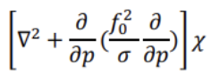
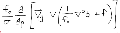
Height Tendency or Omega? Describe the term
Height Tendency Equation
3D Laplace (-x): Represents the tendency of geopotential height to change over time
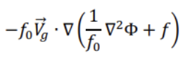
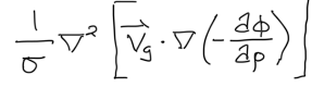
Height Tendency or Omega? Describe the term
Height Tendency Equation
Vorticity advection — “Advection of geostrophic absolute vorticity by geostrophic flow”
B>0 —> -dgZ/dt>0 —> dgZ/dt<0 (heights fall)
B<0 —> -dgZ/dt<0 —> dgZ/dt>0 (heights rise)
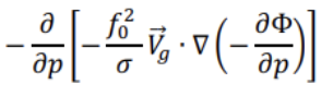
Height Tendency or Omega? Describe the term
Height Tendency Equation
Differential temperature advection: How the temperature advection changes w/ height
+: height falls
-: height rises
-dz/dt = d/dz[Temperature advection]
CAA: d/dz[Temperature advection] < 0
-dz/dt<0 —> dz/dt>0
WAA: d/dz[Temperature Advection] > 0
-dz/dt>0 —> dz/dt<0
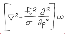
Height Tendency or Omega? Describe the term.
Omega Equation
3D Laplacian acting on ω (-ω=w)
Describes the vertical motion of omega and how its distributed vertically
Height Tendency or Omega? Describe the term.
Omega Equation
Differential vorticity advection term (changes w/ height)
Describes the forcing due to the advection of geostrophic vorticity by the geostrophic wind
*Advection always downstream of trough
Cyclonic voriticty advection (+)
RHS<0 → -d/dz<0 → d/dz>0 (ascent)
Anticyclonic voriticty advection (-)
RHS>0 → -d/dz>0 → d/dz<0 (descent)
Height Tendency or Omega? Describe the term.
Omega Equation
Temperature advection term (Laplacian)
Laplacian[ω] = Temperature Advection
Reflects the influence of temperature gradients on vertical motion. Linked to how WAA/CAA due to temperature differences can induce vertical motion.
CAA: RHS<0 → -ω<0 → ω>0 (descent)
WAA: RHS>0 → -ω>0 → ω<0 (ascent)