Topic 1 - Global Hazards (draft)
1/27
There's no tags or description
Looks like no tags are added yet.
Name | Mastery | Learn | Test | Matching | Spaced | Call with Kai |
|---|
No study sessions yet.
28 Terms
global circulation, air patterns
air moves (circulates) around the world as a system of winds
these winds carry heat from warmer low latitudes to cooler high latitudes and back again, through a system of looped cells, either side of the equator
this figure of 8 pattern, distributes heat around the globe
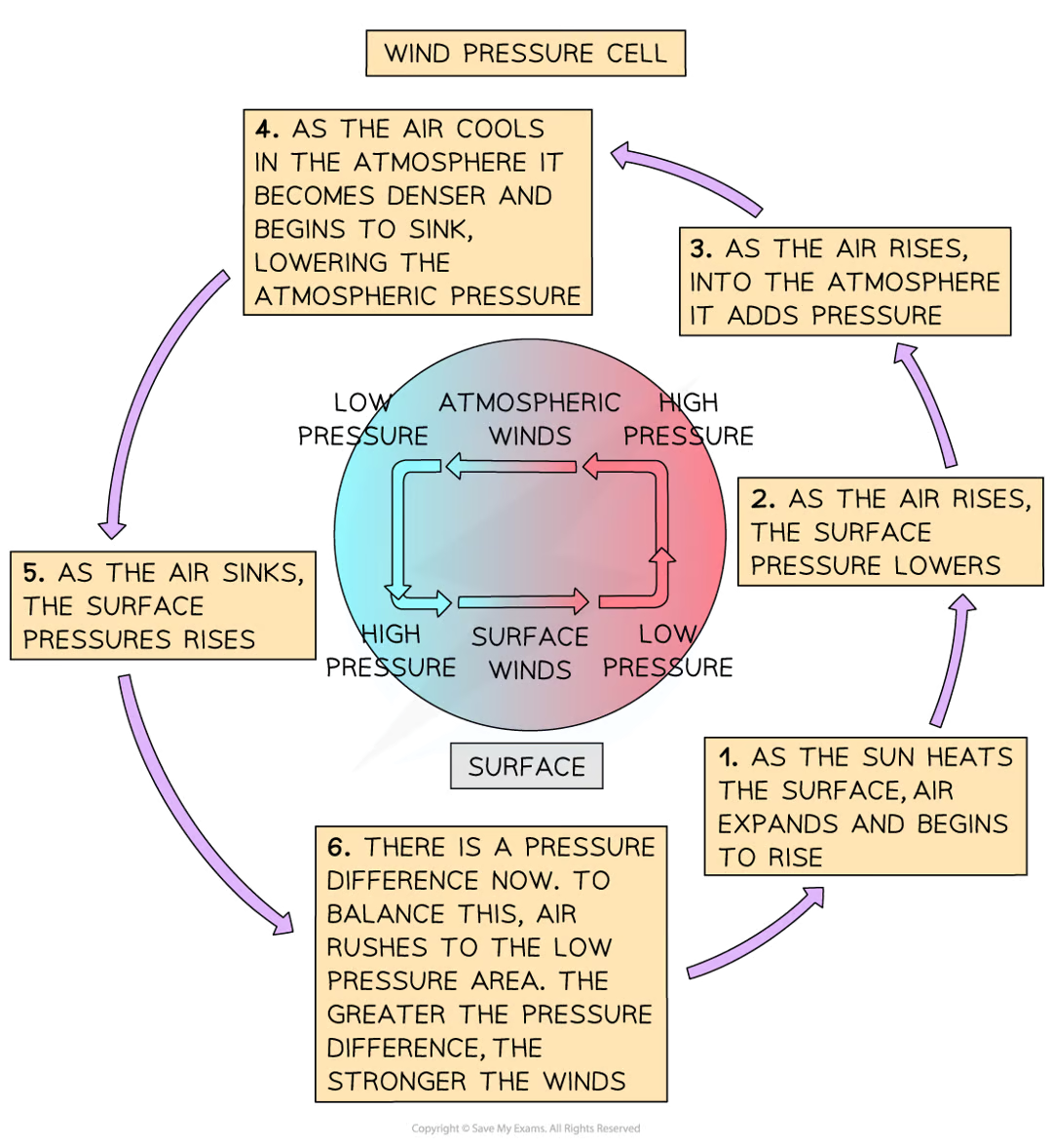
global circulation, wind formation
air moves due to pressure differences, knows as a ‘pressure gradient’
the bigger the difference, the stronger the winds
at the equator, the Sun heats the Earth’s surface and air becomes warmer
the warm air begins rising due to expanding air molecules, which are less dense (heavy) than the air around it
as the air rises, it creates a low pressure zone below the rising air
the area above the rising air, becomes an area of high pressure
as more air rises, it pushes the air apart which begins to cool
cool air is denser, and begins to sink
this sinking air leaves behind an area of low pressure
as it descends back to the Earth’s surface, it starts to form an area of high pressure at the surface
there is now a pressure difference at the surface and this draws the wind back to the area of low pressure
therefore, air always moves from areas of high pressure to areas of low pressure
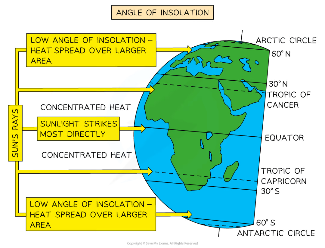
insolation
insolation that reaches the Earth’s surface is greater at the equator and at the poles
this is due to the Earth’s natural curvature and its angle of tilt
the irregular heating of the Earth’s surface, generates several pressure cells. each cells produces a different weather pattern
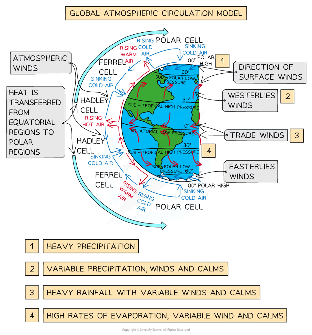
the 3-cell atmospheric wind model
air movement within each cell is roughly circular and moves surplus heat from equatorial regions to other parts of the Earth
the three-cell model shows global circulation: the Hadley, Ferrel and Polar cells
each hemisphere contains three atmospheric cells, known as the Hadley, Ferrel and Polar cell
these cells circulate air from the surface up to the high atmosphere and back down to the Earth’s surface
Hadley cell is the largest cell that starts at the equator and reaches as far as 40° north and south (depending on time of year)
warm trade winds travel in an easterly direction from tropical regions to the equator
as these trade winds meet near the equator, warm air is forced upwards, which quickly cools and condenses forming tropical rainstorms
from the top of these storms, air flows towards the high latitudes, where it becomes cooler and sinks over subtropical regions
this brings dry, cloudless air, which is warmed by the Sun as it descends - the climate is warm and dry (hot deserts are usually found here)
polar cell is the smallest and weakest that reaches from the edge of the Ferrel cell to the poles at 90° north and south
cold air sinks forming high pressure over high latitudes
this cold air flows at the surface, towards the low latitudes
the air is warmed slightly which encourages it to rise and return, at altitude, to the poles
Ferrel cells sits in the middle at the edge of the Hadley cell between 60° and 70° north and south of the equator
unlike the Polar and Hadley cells, the Ferrel cell flows n the opposite direction (creating a figure of 8 type movement)
air joins the sinking air of the Hadley cell and flows at low atmospheric height to mid-latitudes where it then rises along the border with the cold air of the Polar cells
this is the reason why the UK frequently has unsettled weather
Coriolis effect
each cell has prevailing winds associated with it
these winds are influenced by the Coriolis effect
the Coriolis effect is the appearance that global winds, and ocean currents curve as they move
the curve is due to the Earth’s rotation on its axis, and this forces the winds to actually blow diagonally
the Coriolis effect influences wind direction around the world in this way:
in the northern hemisphere it curves winds to the right
in the southern hemisphere it curves them left
the exception is when there is a low pressure system:
in these systems, the winds flow in reverse (anti clockwise in the northern hemisphere and clockwise in the southern hemisphere)
global wind belts, surface winds
the combination of pressure cells, the Coriolis effect and the 3 cells produce wind belts in each hemisphere:
the trade winds: blows from the subtropical high pressure belts (30° north and south) towards the equator’s low pressure zones and are deflected by the Coriolis force
the westerlies: blow from the sub-tropical high-pressure belts to the mid-latitude low areas, but again are deflected by the Coriolis force
the easterlies: polar easterlies meet the westerlies at 60° south
global circulations
global atmospheric circulation affects the Earth’s climate
it creates differences in air pressure and causes some areas to have certain types of weather more frequently than other areas:
the UK has a lot of low pressure weather systems that are blown in from the Atlantic Ocean on south-westerly winds, bringing wet and windy weather
the UK is classified as a temperate weather system as there are no extremes of weather
pressure systems or atmospheric air pressure is measured in milibars
normal range of air pressure is between:
1050mb - high pressure
980mb - low pressure
the lower the pressure system, the higher/stringer the winds become
where are high pressure zones created
air descends exerting pressure on the Earth’s surface
climatic conditions at high pressure zones
air is stable, clear, and dry
winds are low/light
example of high pressure zones
arid - 30° north and south of the equator, high (Sahara Desert) or low (Atacama Desert) temperature with little to no precipitation
polar - 90° north and south with low temperatures, and little to no precipitation (Arctic and Antarctica)
where are low pressure zones created
air rises releasing pressure on the Earth’s surface
climatic conditions in low pressure zones
air is unstable, cloudy, wet with thunderstorms
winds are strong/high
example of low pressure zones
tropical - 0° equatorial region with high levels of rainfall, high temperatures and humidity (Singapore)
temperate - 60° north and south of the equator - moderate weather but can experience extremes of dry or wet weather occasionally (the UK)
where do extreme weather conditions occur
where atmospheric cells meet
extreme weather, winds
winds are relatively weak within pressure belts/zones
between pressure zones/belts, winds are strong
the larger the pressure difference, the stronger the winds
extreme weather, precipitation
precipitation occurs when warm, moist air rises, cools and condenses
air rising in low pressure areas causes frequent precipitation
in high pressure zones, little precipitation occurs - desert regions
extreme weather, temperature
the Equator receives the highest levels of sunlight
these areas are the warmest, but also the wettest
in high pressure zones, temperatures are high during the day, as there is a lack of cloud cover
however, at night temperatures can drop below freezing, due to te lack of cloud cover
the polar regions are very low as little sunlight reaches these areas
UK temperature VS Australia
uk:
cooler than Australia
in London, the average maximum summer temperature is around 23°C
anything above 30°c is considered extremely hot
australia:
warmer than the UK, summers are around 10°c warmer than the UK
in Darwin (northern Australia), the average maximum summer temperature is around 33°c
anything over 40°c is considered extremely hot
UK precipitation vs Australia
UK:
higher precipitation than Australia
average annual rainfall is around 1150mm
extremely wet years have over 1210mm
extremely dry years have less than 950mm
Australia:
lower precipitation than UK
average annual rainfall is around 465mm
extremely wet years have over 550mm
extremely dry years have less than 360mm
UK wind vs Australia
UK:
gales over 62km/h are rare, most places in the UK only have a few days of gales each year
strongest ever sea-level wind was over 220km/h, recorded in Fraserbu1gh, Scotland in 1989