OCR B Geography Paper 1 case study distinctive landscapes
1/15
Earn XP
Description and Tags
River Tees
Name | Mastery | Learn | Test | Matching | Spaced |
|---|
No study sessions yet.
16 Terms
Where is the River Tees located?
cross fell, the highest point in Pennine moorland is the source of the river
What is the geology of the upper course on the River Tees?
whinestone (hard) and limestone (soft)
What does the geology of the upper course lead to on the River Tees?
vertical erosion forming V-shaped valleys-high force waterfall found here
What is the geology in the middle course of the River Tees?
lateral (sideways) erosion forming meanders
What is the geology in the lower course of the River Tees?
large estuary, mudflats and sandbanks
What are the landforms present at the River Tees?
high force waterfall, meanders, river tees estuary
What weathering processes occur at the River Tees?
mechanical, biological and chemical
What erosion occurs at the River Tees?
hydraulic action, abrasion, attrition and corrosion
What transport occurs at the River Tees?
traction, saltation, suspension, solution and longshore drift
What happened at the River Tees in 1995 and how much did this cost?
Tees barrage was completed and costed £54 million
What did the Tees barrage create?
£500 million of investment in offices, housing and leisure
What did the Yarm flood defence scheme of 1995 do?
-re-enforced concrete walls with 30 metal floodgates and earth embankments
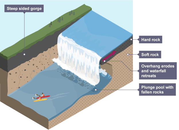
how is a waterfall/gorge formed
soft rock is eroded quicker than hard rock
hard rock is undercut forming an overhang
abrasion and hydraulic action erode to form a plunge pool
overtime the river retreats