Past Exam Questions
 Call Kai
 Learn
Learn Practice Test
 Spaced Repetition
 Match
Match Flashcards
 Knowt Play
1/39

There's no tags or description
Looks like no tags are added yet.
Name | Mastery | Learn | Test | Matching | Spaced | Call with Kai | Chat |
|---|
No analytics yet
Send a link to your students to track their progress
40 Terms
[Ch1] Define navigation.
Getting from known start A to known target B by applying a strategy — needs start position/velocity, target position, position/velocity en route, and a strategy (fastest/shortest/most efficient).
[Ch1] What is GNSS?
The generic term for satellite systems providing autonomous, global geo-spatial positioning (GPS, GLONASS, Galileo, BeiDou).
[Ch1] Name and explain 3 time scales used in GNSS.
UTC (civil standard, has leap seconds), Local Time (sun-based, NOT used in GNSS), GNSS System Time (e.g. GST — continuous atomic time, no leap seconds, offset to UTC broadcast).
[Ch1] Name 2 atomic clocks used on satellites.
Rubidium (RAFS) and Passive Hydrogen Maser (PHM) — "Rb and H-Maser."
[Ch1] How is the longitude-measurement device called?
The marine chronometer (Harrison's H4) — accurate to seconds per day, solved the longitude problem.
Earth spins 360° in 24h, so 1 hour = 15° of longitude — "1 hour, 15 degrees."
Therefore, if a navigator knows the local time (determined by the sun's position) and the time at a known reference point (like Greenwich), they can calculate their longitude.
[Ch1] Name 4 GNSS systems and a unique selling point/specs for each.
GPS (USA, MEO ~20,200km): global standard;
GLONASS (Russia, 19,130km): high-latitude coverage;
Galileo (Europe, ~23,000km): civilian control & high accuracy;
BeiDou (China): hybrid MEO+GEO+IGSO for Asia-Pacific.
[Ch1] What are the motivations for Europe to create Galileo?
Primary: strategic independence (GPS/GLONASS are military-controlled, could be denied in conflicts);
Secondary: capture market share and drive innovation.
[Ch3] Explain how EGNOS works in principle and name its services.
Monitor — RIMS:
36+ precisely located RIMS stations across Europe continuously receive GPS satellite signals.Process — MCC:
Two Mission Control Centres act as the brain. They compare the known RIMS locations with GPS results to calculate errors from clock drift, orbit inaccuracies, and ionospheric disturbances, and check signal integrity.Uplink — NLES:
The MCC creates correction and integrity messages and sends them to Navigation Land Earth Stations.Broadcast — GEO satellites:
The NLES uplink the messages to at least three geostationary satellites, which broadcast the EGNOS corrections across the service area.Apply — Receiver:
EGNOS-compatible receivers combine GPS with the correction signal, giving a more accurate and reliable position.
Services:
Open Service (OS),
Safety of Life (SoL),
EDAS.
[Ch1] Give examples of SBAS.
EGNOS (Europe), WAAS (USA), MSAS (Japan) — "one SBAS per continent."
[Ch1] What is LAAS/GBAS?
Ground-Based Augmentation System (US name LAAS) — local, highly accurate corrections (e.g. airports) via VHF, cheaper/more flexible than ILS.
[Ch3] What are the limits for SBAS / where are SBAS satellites located?
SBAS satellites are geostationary (GEO); coverage is limited to the GEO footprint + ground-station network region.
[Ch3] If you are in South Africa, can you get EGNOS augmentation? Justify.
No — EGNOS only covers Europe (and parts of North Africa/Middle East) via its RIMS network and GEO footprint; South Africa is outside coverage.
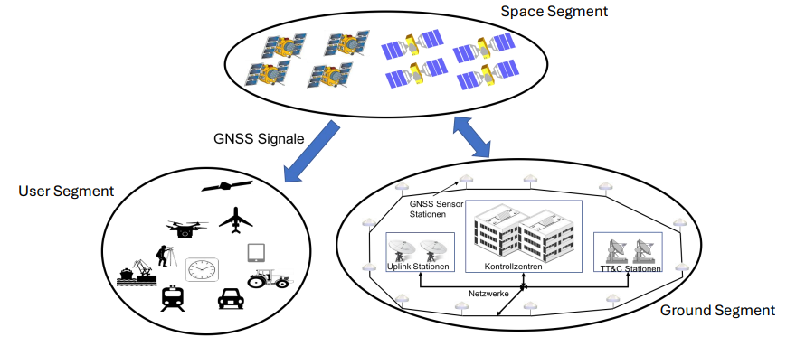
[Ch3] Draw/describe the GNSS architecture and the three segments.
Space Segment (satellites transmit signals),
Ground Segment (monitors/controls satellites, uploads data),
User Segment (receivers computing PVT).
[Ch5] Requirements for interoperability (GPS/Galileo).
Common Time Reference,
Common Geodetic Reference Frame,
Compatible Signal Structure
— "Same Time, Same Place, Same Signal."
[Ch5] In which frequency bands does GPS transmit; Galileo's corresponding bands?
GPS L1/L2/L5 correspond to Galileo E1/E5b/E5a; Galileo also has its own E6 band.
[Ch1,Ch2] LEO/MEO/GEO — where are GPS satellites placed and at what height?
LEO ~160-2,000km,
MEO ~2,000-35,786km,
GEO ~35,786km.
GPS satellites are in MEO (Medium Earth Orbit) at about 20,183 km altitude, in 6 orbital planes separated by 60°, inclination 55°, orbital period 11h 58min.
Memory trick: "GPS orbits twice a day at ~20,000 km — MEO is the GNSS home."
[Ch4] Name 4 geodetic techniques with abbreviations.
VLBI, SLR, DORIS, GNSS — "Very Special Data, Girl."
[Ch4] Explain reference system: what it's for, and how it's realized physically.
A reference system defines the theoretical/conceptual framework (origin, axes, scale) for expressing positions. A reference frame is its physical realization through actual coordinates of a network of tracking stations (e.g. ITRF realized via VLBI, SLR, DORIS, GNSS station coordinates). It is needed so all positions/orbits worldwide can be expressed consistently in the same system.
[Ch4] What is ITRF?
ITRF = International Terrestrial Reference Frame, a global, high-accuracy realization of the Earth-fixed reference frame maintained through combination of the 4 space geodetic techniques (VLBI, SLR, DORIS, GNSS) via the IERS. Positions are transformed between ITRF realizations using the Helmert transformation.
[Ch4] What is coordinate transformation? Named after whom, how many parameters?
It is the transformation between two reference systems (e.g., two Terrestrial Reference Systems), named the Helmert Transformation. Formula: X2 = X1 + T + D·X1 + R·X1, where T = translation, D = scale factor, R = rotation matrix. Memory trick: "Helmert = Translate + Scale + Rotate (7 parameters: 3T + 1D + 3R)."
[Ch2] How many satellites are required to determine position, and why?
4 — three for x,y,z position, one extra for the unknown receiver clock bias.
[Ch2] During position determination, what is measured? What is the basic formula?
Signal travel time (Δt); pseudorange PS = Δt × c — "pseudo" because it's contaminated by clock bias.
LONG:
The pseudorange is measured: the time difference between signal transmission and reception, multiplied by the speed of light. Formula: Pseudorange = (time difference) × (speed of light) = c·Δt. It is called "pseudo" because it includes clock errors, not just true geometric range. Satellite clock error is corrected via the navigation message; receiver clock error is an unknown to be estimated.
[Ch6] Write the pseudorange observation equation and explain the terms. Which has the greatest error influence?
PS=ρS+c(τrec−τS)+IS+TS+ϵ
PS: Measured pseudorange from satellite S.
ρS: True geometric distance between satellite and receiver; depends on unknown receiver position (x,y,z).
c: Speed of light.
τrec: Receiver clock bias — unknown and solved with position.
τS: Satellite clock bias — known correction broadcast in the navigation message.
IS: Ionospheric delay caused by charged particles in the upper atmosphere.
TS: Tropospheric delay caused by pressure, temperature, and humidity in the lower atmosphere.
ϵ: Other errors, mainly multipath and receiver noise.
Clock bias is largest but solved; ionosphere is the biggest remaining environmental error.
[Ch2] What types of atmospheric disturbances affect GNSS signals?
Ionospheric delay (upper atmosphere)
where solar radiation creates a layer of free electrons
frequency-dependent
Tropospheric delay (lower atmosphere/weather)
where all weather events happen
not frequency-dependent
— "Iono up high, Tropo down low."
[Ch2] Which atmospheric disturbance depends on frequency, and its impact?
Ionospheric delay — frequency-dependent, causes 2-50m error, lets dual-frequency receivers cancel it.
This property allows dual-frequency receivers to measure and largely eliminate the ionospheric error, which can range from 2 to 50 meters
[Ch2] Which atmospheric disturbance can you eliminate, and how?
Ionospheric delay, via dual-frequency Ionosphere-Free combination. Tropospheric delay needs a numerical model instead.
[Ch2] What does ionospheric delay cause?
Delays the code-phase but ADVANCES the carrier-phase — opposite signs for code vs carrier.
(This layer slows down the code part of the signal and advances the carrier phase.)
[Ch2] Two approaches to tackle disturbances (general)?
Modeling (estimate with a model, e.g. troposphere) or Elimination (remove directly, e.g. dual-frequency combo for ionosphere).
[Ch2] Why do clock errors occur? Causes?
Relativity — Special Relativity slows the clock (speed), General Relativity speeds it up (weaker gravity); General wins, +38 μs/day, corrected by pre-tuning clocks slower before launch.
LONG: Relativistic effects. Special relativity: a fast-moving satellite clock (~3.9 km/s) runs slower as seen from Earth (time stretched by 8×10⁻⁹%). General relativity: weaker gravity at altitude makes the clock run faster (time shortened by 53×10⁻⁹%). Net effect: satellite clock runs fast by ~45×10⁻⁹%, so it's deliberately slowed down by 38 µs/day before launch. Memory trick: "Special relativity slows it, General relativity speeds it up more — net: satellite clocks run fast, so we detune them."
[Ch2] Explain the Keplerian Elements / how many parameters describe a full orbit?
Ω (Right Ascension of Ascending Node - orientation of plane),
i (Inclination - orientation of plane),
ω (Argument of Perigee - orientation of orbit within plane),
a (Semi-major axis - shape/size),
e (Eccentricity - shape),
ν (True Anomaly - position along orbit at a given time).
Memory trick: "2 orient the plane (Ω, i), 1 orients the orbit in the plane (ω), 2 define shape (a, e), 1 gives position (ν)."
[Ch2] Name orbit types with eccentricity values.
Circular e=0
Elliptical 0<1
Parabolic e=1
Hyperbolic e>1
[Ch2] What are Apogee and Perigee?
Apogee: farthest point, satellite SLOWEST;
Perigee: closest point, satellite FASTEST
(Kepler's 2nd Law).
[Ch6] Explain the covariance matrix.
(ATA)⁻¹ from least squares — diagonal elements are variances (uncertainty) of x,y,z, clock bias; basis for DOP.
The covariance matrix describes the uncertainty and correlations of the estimated position/time parameters, computed from the design matrix A (which depends only on satellite geometry as seen from the receiver). Its diagonal elements give the DOP values. Because A can be computed in advance from the satellite almanac, you can "design" a survey (choose the best observation time) to minimize DOP before even collecting data.
[Ch6] Overdetermined system / least squares method — explain.
More than 4 satellites = overdetermined, no exact solution due to noise; least squares finds the best fit minimizing squared residuals: x̂ = (ATA)⁻¹ATb.
With four unknowns (x, y, z, and τrec), we need a minimum of four satellite measurements to find a solution. When we have more than four measurements, the system is over-determined and has no single exact solution due to measurement noise. We must therefore find the best fit solution
The standard method for this is least squares estimation. The goal is to find the set of unknown values that minimizes the sum of the squares of the residuals (the differences between the observed measurements and the values predicted by our model).
[Ch6] Determine state vector and design matrix H for single-freq PR observation of GAL and GPS, GST reference.
x=[Δx,Δy,Δz,ΔdTRx,ΔdtGGTO]ᵀ; columns 1-3=geometry, column 4=c (all sats), column 5=0 for Galileo, c for GPS (GGTO correction) — "0 for home team, c for the visitor."
[Ch2,Ch7,Ch9] What are the challenges for a receiver placed on a satellite?
High velocity → large Doppler shifts; moving dynamic platform; weaker/directional antenna geometry; harsh radiation environment; own position must be estimated (POD).
[Ch9] Describe dynamic orbit determination — advantages and disadvantages.
Physics-based: models gravity/drag/solar pressure, fits via least squares (Guess→Predict→Compare→Fix→Repeat).
Uses mathematical force models to numerically integrate the satellite's equations of motion, producing a "reference orbit," which is then fit to GNSS measurements via Least Squares or Kalman Filter.
Advantage: smooth, bridges gaps, averages noise.
Disadvantage: accuracy depends on force-model quality — wrong drag model = bias.
[Ch9] Describe the concept of kinematic orbit determination.
Purely geometric — computes position independently each epoch (like PPP), NO force models; used for very LEO (drag hard to model); noisier but bias-free.
Orbit determination using only measurements (e.g. GNSS), with NO dynamic force model. Used when dynamic models would be too inaccurate (e.g. low-altitude drag). Examples: PVT solutions, PPP (Precise Point Positioning). Memory trick: "Kinematic = measurements only, no physics assumed."
[Ch8] What is PPP? Real-time considerations, corrections, difference from DGNSS/RTK?
Single-receiver, dual-frequency, ionosphere-free, global cm-dm accuracy, no base station. Real-time: NTRIP delivery, 10-30 min convergence, PPP-AR speeds it up. Corrections: orbits, clocks, biases. vs RTK/DGNSS: those need a local station for fast RELATIVE position; PPP is GLOBAL but slower to converge.
PPP is a positioning technique using a single receiver with undifferenced, dual-frequency pseudorange and carrier-phase observations, combined with precise satellite orbit and clock products, to achieve dm-to-cm accuracy without nearby reference stations. It is a pure kinematic concept (no dynamic model). For real-time use: need real-time precise orbit/clock corrections (streamed from a global network), long initialization/convergence time, and integer ambiguity resolution are challenges. Corrections needed: satellite orbit, satellite clock, ionospheric-free combination, tropospheric model, and ambiguity resolution (PPP-AR) for faster convergence.
DGNSS/RTK are differential/relative techniques requiring one or more nearby reference stations, giving cm(RTK)/mm accuracy over short baselines. PPP is an absolute, global technique using only precise orbit/clock products (no local reference station needed), giving cm-dm accuracy anywhere globally, but needs longer convergence time. Memory trick: "DGNSS/RTK = relative + local station; PPP = absolute + global product."
[Ch2,Ch9] Moon question — where to position a satellite for the Moon's south pole, and why?
At Apogee — Kepler's 2nd Law means slowest speed there, giving the longest dwell time over the target, even though DOP may be worse.