Aircraft Systems, Navigational Aids, and Instrument Approaches
1/169
There's no tags or description
Looks like no tags are added yet.
Name | Mastery | Learn | Test | Matching | Spaced | Call with Kai |
|---|
No analytics yet
Send a link to your students to track their progress
170 Terms
What type of engine does the Archer II have? What does each letter mean?
Lycoming O-360-A4M or CL4HAND
C Carbureted
L Lycoming
4 4-Stroke
H Horizontally Opposed
A Air Cooled
N Naturally Aspirated
D Direct Drive
*360 is the engines total piston displacement in cubic inches
What type of oil do we use? What about hydraulic fluid?
S.A.E. 40, and MIL-H-5606
What is our maximum Ramp, Takeoff, and Landing Weight?
Ramp: 2558
Takeoff: 2550
Landing: 2550
What are the two principles of gyroscopes?
Rigidity in Space: Maintain orientation in space and resists changes.
Precession: A force applied to the gyroscopic will be felt 90 degrees in the rotation of the gyroscope
Which instruments usually use a gyroscope?
Attitude Indicator, Turn Coordinator and the Heading Indicator
What is the difference between a Turn Coordinator and a Turn-and-Slip Indicator
Turn Coordinator shows rate-of-turn and rate of roll, while the Turn-and-Slip Indicator shows only the rate of roll.
What are our Pitot-Static instruments?
Altimeter, Airspeed Indicator, and Vertical Speed Indicator
How does the Altimeter work?
The casing is fed by the static pressure from the static port. This pressure fills the casing surrounding a stack of aneroid wafers. This wafer is sealed with a pressure of 29.92”. If the pressure outside the wafer is higher then the wafer compresses, showing a decrease in altitude, if it expands it shows an increase in altitude.
How does the aneroid wafer expanding and contracting translate to an altitude?
When the aneroid wafer contracts that means the aircraft is descending or at a lower altitude, while expansion means the aircraft is climbing/high altitude.
How does the attitude indicator work?
The attitude indicator uses the gyroscopic principle of rigidity in space to keep its orientation. The gyro has two gimbals that are connected to the bank and pitch indicator. So as the aircraft moves the gyro stays still but the gimbals show a pitch or bank indication.
What errors is the Attitude Indicator subject to?
Calibration, Acceleration, Steep turns exceeding 100° 110° degrees, and Steep climb exceeding 60° to 70°
Last two can cause the instrument to tumble
What are some types of deicing and anti-icing equipment?
Deicing:
Pneumatic Boots
Electro-Mechanical Expulsion Deicing (EMEDS)
Chemical Deicing
Anti-icing:
Weeping Wing
Bleed Air Systems
Propeller Anti Ice
What is a “Sensitive Altimeter”? What is the window that displays the pressure setting called?
An altimeter with an altimeter setting knob. Kollsman Window.
When flying for an area of high to low pressure what should you keep in mind?
Flight to an area of high to low pressure will cause the indicated altitude to be lower than the true altitude.
Name and define each type of altitude:
Indicated: Uncorrected altitude indicated when altimeter set to local pressure setting
Pressure: Altitude above standard pressure
Density: Pressure altitude corrected for non-temperature
Absolute: Height above the ground
True: Altitude above Mean Sea Level
How does the Vertical Speed Indicator work?
A diaphragm inside the instrument receives static air, the casing also receives air but has a calibrated leak (~6-9 seconds) which keeps old air pressure inside for a short while this allows the diaphragm to expand and contract as you climb/descend
Diaphragm contracts = climb
Diaphragm expands = descent
How does the Airspeed Indicator work?
Inside the airspeed ind. there is a diaphragm which is connected to the ram air intake, the casing surrounding this diaphragm is connected to the static port and is fed by static pressure. So when pressure increases in the diaphragm the pressure in the case must decrease, and vice versa.
When the aircraft starts moving air is rammed into the pitot tube, the pressure increases in the diaphragm, meaning less static pressure is present in the casing. Based on this pressure difference an airspeed indication is shown.
Name and define each type of speed:
Indicated: What the instrument displays
Calibrated: IAS corrected for instrument & position errors
Equivalent: CAS corrected for compressibility errors
When going extremely fast
True (TAS): Actual speed of the aircraft through the air, CAS corrected for non-standard temp and pressure
Ground Speed: Speed over the ground, also TAS corrected for wind
What is Equivalent Airspeed actually correcting for?
At fast speeds the air compresses inside the pitot tube, this increases the pressure inside the instruments diaphragm which indicates an incredibly high airspeed.
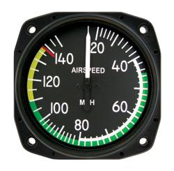
What does each airspeed indication mean?
White Arc: Flaps extended speed, between Vso - Vfe
Green Arc: Normal operating range, starts at Vs1 and ends at Vno
Yellow Arc: Caution range, fly only in smooth air
Red line: Vne
What is all of our V-speeds?
Vso: 45
Vs1: 50
Vr: 60
Vx: 64
Vy: 76
Vref: 76
Vfe: 102
Va: 89-113
Vno: 125
Vne: 154
What happens if the Pitot Tube is blocked (Static is clear)?
ASI: Reads Zero
Altimeter: Nothing
VSI: Nothing
What happens if the Pitot Tube and Drain Hole are blocked?
ASI: Acts like an altimeter, increases with a altitude, and decreases with altitude
Altimeter: Nothing
VSI: Nothing
What happens if the Static Port is blocked (Pitot is clear)?
ASI: Acts opposite to an altimeter, increases with a descent, and decreases with a climb
Altimeter: Frozen in place
VSI: Reads Zero
What are some ways you can remedy an inaccurate Altimeter or VSI?
Using the Alternate Static Source, breaking the VSI glass if that does not work
Why do we have to constantly align the Heading Indicator with the Magnetic Compass?
Due to precession inside the instrument
What are the magnetic compass errors and limitations?
D Deviation: Avionics magnetic field.
V Variation: Isogonic lines.
M Magnetic Dip: Varies based on distance to poles.
O Oscillation: Turbulence or rough air
N North/South turn errors (UNOS)
A Acceleration errors (ANDS)
What is an Attitude Heading Reference Systems (AHRS)?
A more advanced version of the gyroscopic instruments that provides accurate data.
What is an Air Data Computer (ADC)?
Replaces the mechanical pitot-static instruments, ADC receives input from pitot, static, and outside temp ports, and computes: airspeed, true airspeed, vertical speed, and altitude.
What is a flight director?
Computes and displays purple bars over the attitude to help in flight
What is a Flight Management Systems?
Receives input from various systems and sensors and provides guidance to the autopilot and flight director.
What is an Electronic Flight Instrument System?
A Glass Cockpit
What is a Primary Flight Display (PFD)?
Displays flight data such as attitude, altitude, airspeed, VSI, and heading as well as rate tapes.
What is a Multi-Function Display (MFD)?
Display secondary information, like maps, system status, weather, and traffic. Can also be used as a backup for other displays.
When is an approved flotation device for each occupant, and at least pyrotechnic signaling device?
When more than 50 NM from the shore
What is the VOR MON (Minimum Operation Network) do?
A program that ensures that as old VORs are phased out, a MON airport (with legacy ILS or VOR approaches) is available within 100 NM is available regardless of aircraft position in the CONUS.
This is so if a widespread GPS failure were to happen, pilots can navigate to land.
Increases NAVAID service volume
What are the different VOR Receiver Checks?
V VOT: ± 4
O Over a prominent landmark, minimum 20 NM at a reasonably low altitude: ± 6
D Dual: ± 4
G Ground: ± 4
A Airborne: ± 6
R Repair Station: ± 4
What is the required information needed to be logged after a VOR check?
DEPS
D Date
E Error (bearing error)
P Place
S Signature
What are the limitations that a VOR has?
Cone of Confusion
Propeller Modulation: Signal passes through propeller (Max error 6°)
Reverse Sensing: Flying TO the station on a FROM indication.
Bending & Scalloping: VOR transmission reflects of buildings and terrain (Max error of 2.5°)
How do you know if a VOR is not working?
When tuning and IDing the VOR the coded identification is not heard, or TEST is heard via morse code.
Where can you find VOR and DME service volumes?
In AIM 1-1-8
Where can you find the frequencies VOR and DME’s occupy?
VOR: AIM 1-1-3
DME: 1-1-7
How does DME work?
The aircraft transmits an “interrogation” signal which is received and replied to by the ground DME facility. The airborne unit then calculates the slant range distance to the station based on reply time.
What is slant range error? When is it negligible?
Slant-range error is an error found when too close to the station at high altitudes. For example, a DME will display your altitude when over the station.
When over the station at 5,000’ the DME will show 5
Rule of thumb is to be 1,000’ per 1 NM away from the station
What is an ADF?
An Automatic Direction Finder which points towards the NDB
What are the NDB Service Volume Classes?
Compass Locator: 15 NM
Medium High (MH): 25 NM
High (H): 50 NM (Or less, see NOTAM or Chart Supplement)
High High (HH): 75 NM
What is a compass locator?
An NDB used in conjunction with an ILS approach
How does an ADF work?
You tune in an NDB station on the ADF, the instrument will then show the direction of that NDB. Some ADF’s show the bearing relative to North, some show relative to aircraft.
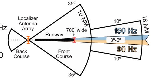
What is a Localizer? What is its range of frequencies?
A part of a landing system that gives later course guidance.
Draw what a Localizer looks like:
Draw what an ILS looks like:
What is the width of the LOC?
Between 3 to 6 degrees, this is so the width at the threshold is 700’ wide
What is the coverage range of a LOC?
First 10 NM: 35 degrees to each side of the centerline
Last 18 NM: 10 degrees from each side of the LOC antenna up to 4,500’
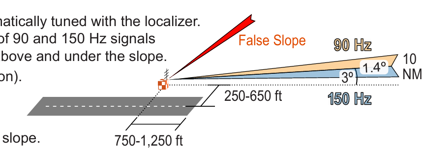
How does the glide slop know how high or low the aircraft is?
Vertical position is interpreted by the intensity of the 90 and 150 Hz signal carried over the UHF frequency and directed above and under the slope
What is the width of the glide slope?
Width is 1.4 degrees, full deflection is 0.7 degrees.

What is the range of the glideslope?
Up to 10 NM
What is a “False Glideslope”?
A secondary glide slope above the actual one. This false glide slope has a very steep descent rate inconsistent with an actual glide slope.
What does the Outer Marker Mean? How can we identify it from the others?
Usually 4-7 miles out and indicates when the GS should be captured or the FAF.
Morse Code: “- - -”
Light flashes blue
What does the Middle Marker Mean? How can we identify it from the others?
Usually identifies decision height.
Morse Code: “. - . -”
Light flashes amber
What does the Inner Marker Mean? How can we identify it from the others?
Indicates GS and DA intersection on CAT II ILS.
Morse Code: “. . .”
Light flashes white
What does the Back Course Marker Mean? How can we identify it from the others?
Indicates FAF on selected back course approaches
Morse Code: “.. ..”
What is an Approach Light System?
Basic visible indications between instrument guided flight into a visual approach.
How far from the landing area does ALS for a Non-Precision Approach Runway extend?
1,400’ to 1,500’
How far from the landing area does ALS for a Precision Approach Runway extend?
2,400’ to 3,000’
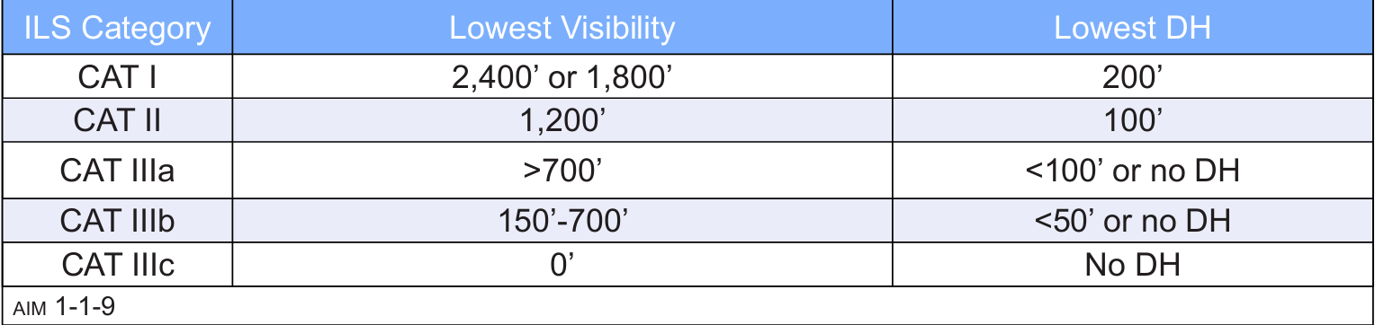
What is the lowest visibility for each category of ILS? Where can you find this?
AIM 1-1-9 (i)
What is RNAV?
Area Navigation that allows flying any desired path, without needing to overfly ground-based facilities.
What are the types of RNAV?
Global Navigation Satellite System (GNSS)
VOR/DME RNAV
DME/DME RNAV
Inertial Reference Unit/System (IRU/IRS)
What is RNAV VNAV and BARO-VNAV?
1. Vertical Navigation Guidance
2. An RNAV system that uses barometric altitude to compute vertical guidance
What are the types of published RNAV routes?
Q-Routes: FL180-FL450
T-Routes: 1,200’ AGL-18,000’ MSL
*Both designated as RNAV 2 unless charted as RNAV 1
What type of RNAV routes do we fly?
T-Routes
What is Magnetic Reference Bearing (MRB)?
The published bearing between two waypoint on an RNAV route?
How many satellites make up the GPS constellation?
Minimum 24 orbiting at 10,900 NM, designed so 5 are at view at any time.
How many satellites are required for 2D and 3D position?
2D: 3 Satellites
3D: 4 Satellites (Latitude, Longitude, and Altitude)
What is Receiver Autonomous Integrity Monitoring (RAIM)?
A function of GPS receivers that monitors the integrity of the satellite signals
How does RAIM Fault Detection work?
Requires minimum of 5 satellites or 4 + baro-aided RAIM to detect a faulty signal
How does RAIM Fault Exclusion work?
To eliminate a corrupt satellite RAIM needs an additional satellite (6 or 5 + baro-aid), the new satellite replaces the corrupt one
What is great-circle navigation?
Computes the shortest path between two points
Can GPS substitute ADF or DME?
Yes, except for ADF on an NDB approach without GPS overlay (“or GPS” in the title)
How can a pilot make sure RAIM is available for the entire flight?
By using the FAA’s RAIM prediction tool, and checking GPS NOTAMS
What is GPS Augmentation System or Differential GPS (DGPS)?
Improve the accuracy of GPS by measuring errors received by reference stations at knows locations and transmitting these errors to GPS receivers.
What is Satellite Based Augmentation System (SBAS)?
WAAS but for other countries. Uses ground stations along with satellites to improve signal accuracy.
What is Ground Based Augmentation System (formerly Local Area Augmentation System (LAAS))?
Errors broadcasted via VHF to GBAS-enabled GPS receivers, more accurate than WAAS but covers a smaller area.
Allows for Cat I and above approaches to GLS DA minima
What is Required Navigation Performance (RNP)?
RNP is RNAV with the added requirement for onboard performance monitoring and alerting. It’s also a statement of navigation performance for operation in specified airspaces.
What does it mean when an approach is “RNAV (RNP)”?
It means the approach is “Authorization Required” and need special permission from the FAA for the crew, aircraft, and operation.
Other countries may have “RNP” in the approach title without needing permission
What is PBN (Performance Based Navigation)?
The general basis for navigation equipment standards in terms of accuracy for specific situations (approach, enroute, missed approach).
What is the RNP accuracy for Enroute, Terminal & Departure, and Final Approach?
Enroute: 2 NM 95% of flight time
Terminal & Departure: 1 NM 95% of flight time
Final Approach: 0.3 NM 95% of flight time
What is Advanced RNP (A-RNP)?
A type of RNP that covers all phases of flight:
RNP 2, RNP 1 for departures and arrivals, and RNP APCH
What are the three categories of approaches?
Precision, Non-Precision, and APV
What is a Precision Approach?
An approach with:
Vertical Guidance
Uses Decision Altitude
Meets approach standards of ICAO annex 10
What is a Non-Precision Approach?
An approach with:
No vertical guidance
Uses a Minimum Descent Altitude
What is an APV approach?
A GPS approach with:
Vertical Guidance
Uses DA
*APV are considered non-precision due to some legal standards with the ICAO, but are still very precise.
What are the types of precision approaches?
ILS - Instrument Landing System
PAR - Precision Approach Radar
GLS - GBAS Landing System
What is a PAR approach?
ATC use radar to guide pilots during final approach, lateral and vertical (Precision).
What is a GLS approach?
A GBAS based approach that uses GPS and ground transmitters (Precision).
What is an LP approach?
A GPS with WAAS approach that is used when an LPV approaches aren’t allowed due to obstructions or terrain.
What is an ASR approach?
ATC use radar to guide pilots during final approach, only lateral (NPAP).
What is an LNAV approach?
A GPS approach with Lateral Navigation (NPAP).
What is an LPV approach?
Localizer performance with Vertical Guidance, which requires GPS and WAAS.
What is an LNAV/VNAV approach?
A type of APV approach that vertically and laterally guides an aircraft to a DA. Requires WAAS or RAIM + Baro-VNAV
What is the difference between LNAV + V and LNAV/VNAV
LNAV + V is advisory only vertical guidance and is flown to MDA
LNAV/VNAV is flown to DA