Unit 2 weather and climate
1/87
Earn XP
Description and Tags
World's major climate groups
Name | Mastery | Learn | Test | Matching | Spaced |
|---|
No study sessions yet.
88 Terms
The World’s major climate zones- The Koppen Classification
this classification divides the world’s climates into 6 main zones and numerous sub zones.
What are the 6 main climatic zones?
equitorial
arrid
mediterranean
temparate
snow/mountains
polar
what are the characteristics of equitorial zones?
lie either side of the equator
high rainfall year round
high temps
avg temp 20-30 degrees
rainfall >60mm a month
What are the characteristics of arrid zones?
almost permenant areas of high pressure across sub tropics
cloudless skies due to air sinking
extremely dry with large temp variations between day and night.
What are the characteristics of temperate zones?
rainfall evenly distributed throughout the year
cold winters
hot summers
what are the characteristics of mediterranean zones?
dry summers
mild wet winters
What are the characteristics of polar zones?
no months of a year above 10 degrees
long periods of darkness in winter, ice and snow cover
very low precipitation.
Seasonality of Climate: what is the key characteristic of all climates of the world?
seasonal variation
What causes seasons?
The earth’s axis being tilted at 23.5 degrees. This affects the intensity of insolation at any point on the Earth surface during a year
Explain the effect of the Earth’s tilt on surface received insolation in the NORTHERN HEMISPHERE
The point on the Earth’s Surface where the sun is directly overhead at 90 degrees to the surface known as the ‘Heat Equator’ varies throughout the year
in the northern hemisphere, the summer solstice occurs on the 21st of june whilst in the southern hemisphere this is the winter solstice
on this date, the sun‘s rays strike the Earth’s surface at 900 at the Tropic of Cancer, located 23.5 north of the Equator.
Within the Arctic Circle located above 66.5N there is 24 hours of daylight whilst within the Antarctic circle located at 66.5S there is 24 hours of darkness
Explain the effect of the Earth’s tilt on surface received insolation in the SOUTHERN HEMISPHERE
On the 21st dec, the southern hemisphere is experiencing its summer solstice, when the sun is directly overhead at the Tropic of Capricorn. The Northern hemisphere is now experiencing its winter solstice
What are the Vernal and Autumnal Equinoxes?
march 21st- The Earth experiences the Vernal Equinox
sept 22nd- Autumnal Equinox
on these dates the sun’s rays strike the Earth’s surface at 90 degrees. Everywhere on the planet experiences 12 hours of daylight and 12 hours of darkness. ,
The Effect of the Earth’s tilt on the Tricellular Model: The seasonal shift of the tricellular model.
throughout the year the pattern of the tricellular model shifts:
northwards towards from dec to june
southwards from june to dec
What is the seasonal shift of the tricellular model like during the June Solstice in the Northern Hemisphere?
In the june solstice, the tricellular model shifts northwards towards the northern hemisphere
the polar cell is comtracted in the nrothern hemisphere
the polar cell is enlarged in the southern hemisphere as they are experiencing their winter solstice
What is the seasonal shift of the tricellular model like during the December Solstice in the Northern Hemisphere
in the dec solstice, the tricellular model shifts southwards towards the southern hemisphere and away from the nothern hemisphere.
the polar cell at the nothern hemisphere is enlargened.
polar cell is contracted in the southern hemisphere as the summer solstice is being experienced in the south.
what is the seasonal shift of the tri cellular model like during the Equinoxes?
During the equinoxes,
the tricellular model remains balanced, with the cells evenly distributed between the Northern and Southern Hemispheres.
Both polar cells are of equal size, and neither hemisphere experiences a significant seasonal shift.
what does the shift of the heat equator and subsequent movement of the 3 atmospheric cells cause?
large seasonal variation in climate
What is the meeting of two Hadley Cells (two low-pressure zones) known as?
The Inter-Tropical Convergence Zone (ITCZ)
moves northwards and southwards with the shift of the heat equator throughout the year.
Shift of the ITCZ: how does the ITCZ move?
The ITCZ moves in response to the movement of the heat equator (where the sun is directly 90 degrees above the earth’s surface)
where is the movement of the heat equator most pronounced?
most pronounced over large land masses which heat up more quickly than areas of the ocean.
how does the ITCZ shift in the summer?
ITCZ shifts northwards in the summer as the heat equator is concentrated at the tropic of cancer which is 66.5N
what are the weather conditions like of the ITCZ in July
ITCZ has shifted northwards
precipitation
warm conditions
and thunderstorms due to rising air and convergence.
how does the ITCZ shift in the winter?
in the winter, the ITCZ shifts further south towards the southern hemisphere as as the heat equator is concentrated above the Tropic of Capricorn
why do ocean currents (the Benguela Current) alter the ITCZ In January?
The Benguela current is a cold water current so warm air isn’t allowed to rise. ITCZ doesn’t shift because of the ocean current.
what kind of seasonal changes are caused due to the shift of the ITCZ within the tropics?
seasonal changes in wind direction and in precipitation often leading to a wet and dry season.
where this occurs in the tropics, it is known as a ‘Monsoon’ climate
Effects of the shifting ICTZ in Mongu, Zambia (Africa)
MONGU, ZAMBIA
precipitation is high in the months of Jan-march and december, with aprrox 20cm of rainfall:
this is because the ITCZ is at this location (Zambia is located in a more southerly position so the heat equator is concentrated above the tropic of capricorn so the ITCZ has shifted southwards.
precipitation is low in the months of April- November with aprrox 0-5cm of rainfall.
this is because the ITCZ is located futher north.
Effects of shifting ITCZ in Abeche, Chad (Africa)
precipitation is high in the months of July-August with aprrox 20cm of rainfall:
this is because the ITCZ is at this location( chad located northwards so the heat equator is at the Tropic of cancer so the ITCZ has shifted northwards)
Precipitation is low in the months of sept-june with approx 0-8cm of rainfall:
this is because the ITCZ is located further south (heat equator located at the Tropic of Capricorn so the ITCZ shifts southwards)
what does the term monsoon mean
refers to a seasonal change in wind direction. Wind direction changes are linked to changes in atmospheric pressure.
How do winds blow over the surface?
Winds blow over the surface from an area of high pressure to an area of low pressure
so what happens if the atmospheric pressure of an area changes?
thhe wind direction changes and so does the weather
What does the annual shift of the heat equator between the tropics lead to?
can lead to a low pressure shift in the low pressure ITCZ and consequently wind direction which leads to a monsoon.
What area of the world is the seasonal monsoon very concentrated over?
India
THE START OF THE PROCESS: The hot, dry seasson (FEB-MAY)
this season occurs all over India.
in the interior, especially the north, temps continually rise as the heat equator shifts northwards
the land begins to heat up more than surrounding ocean and by May the temps can exceed 40 degrees over the landmass of India which is 20 degrees more than the surrounding ocean.
the land heats the atmosphere and warm air begins to rise creating an area of low pressure.
THE SUMMER SOUTH-WEST MONSOON: Rainy season, June-August
By June, the low ITCZ starts shift northwards (heat equator focused at Tropic of Cancer)
a south westerly wind develops as warm moist air from the Indian Ocean is drawn into the low pressure
as this moist air rises at the ITCZ it results in rainfall
by mid-July the monsoon rains have reached the entire country.
characteristics of the rainfall experienced here?
precip leveks are typically between 300-700mm which occur during these three months
additional orographic uplift effect such as the uplands of the Western Ghats (1500m high, 2000m of rainfall) areas near here will see even higher levels ofprecip due to orographic rainfall
similar effect when the summer monsoon winds reach the Himalays =.
THE WINTER MONSOON: Cool, dry season Sept-Jan
As the heat equator travels southwards towards the tropic of capricorn, insolation levels drop and the land mass of India starts to cool down.
however, the indian ocean has a higher specific heat capacity which means it retains more of its heat. THIS CAUSES the ocean to have warmer air above it and therefore this is where the low pressure ITCZ shifts to
the cold air mass experiences high pressure which leads to wind direction reversing, and a cool northerly wind travels over the dry continent from the cold moutains of the Himalayas
Consequently, during dec-jan much of northern India has an average temp of below 15 degrees and receives virtually no rainfall.
What other factors impact upon tropical climate?:
Ocean currents: El Nino Southern Oscillation (ENSO) .
what happens in normal conditions?
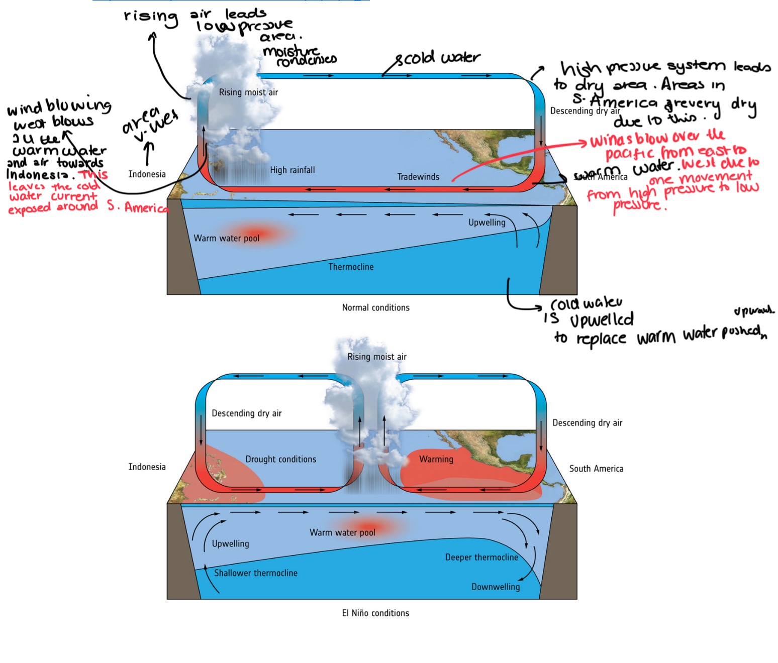
what are the El Nino conditions?
surface winds switch directions and blow warm water towards an area of previous high pressure (S.America)
during an el nino event, Indonesia will experience drought conditions as there is no longer warm air being supplied instead only cold air
warm water pool shifts depending on how strong the El Nino event is, in stronger el nino events, S.America will see low pressure and have high levels of rainfall
El Nino, distrupts global weather patterns and can increase global temps when it occurs
Explain La Nina
strong trade winds blow warm water towards the western pacific (Indonesia) and warm surface water is replaced by upwelling of colder water .
as water is quite cold, there is an area of high pressure located above it.
warm water in the western pacific causes warm, moist air to rise forming an area of low pressure
warm air rises, cools and condenses and forms heavy rainfall.
In a La Nina event, the water is warmer than normal which is why rainfall is much heavier and the upwelled water is colder than normal resulting in drier conditions. This can distrupt global weather patterns as well
What other factors impact upon tropical climate?:
Altitude- what is the impact of altitude on Monsoon climate in India
Altitude can affect monsoon climate in India by altering temperature and precipitation patterns.
Higher altitudes typically experience cooler temperatures, which can lead to increased precipitation as warm, moist air is forced to rise, cool, and condense,
The climate and weather of the UK: what is the climate of the UK?
the UK has a cool temperate climate. The temperate zone of the planet is that which lies between sub-tropical and polar zones.
what is the cool temparate climate of the UK is characterisied by?
mild temps (5-20)
high humidity and precipitation averaging 800mm throughtout the year
what are three factors that affect the average temp throughtout the UK
altitude
latitude
distance from the sea( nearer to the coast= warmer temps)
In january, where are the warmest parts of the UK?
around the southern and western coasts while cornwall has the warmest temps averaging over 17 degrees.
Understanding the levels of precipitation in the UK: what type of rainfall is the UK subject to?
orographic
frontall
convectional
what is the correlation like between precipitation and altitude?
very strong- in areas of higher ground (scottish highlands) there is greater rainfall
what is the average total rainfall for the UK?
800mm
What is the driest location of the UK?
St Osyth, Essex avg rainfall level of 507mm
what is the wettest locations in the UK?
Snowdownia,, The lake District
all which recieve over 3000mm of rain per year
Understanding the patterns of Wind in the UK:
why do most winds come from the south west?
winds come from the south west because wind moves from high pressure to low pressure from the west direction. They curve due to Coriolis Effect- this causes a dominant south west direction.
Understanding air masses- what is an air mass?
an anir mass is a large body of air with distinctive characteristics. When the wind blows from different directions, it brings with a particular type of weather because of the air mass from which the wind originates.
What are the 6 types of air masses?
polar maritime (NORTH)
returning polar maritime (WEST)
tropical maritime (SOUTH)
arctic maritime (NORTH)
polar continental (EAST)
tropical continental (SOUTH EAST)
what is a maritime air mass?
relates to wind that has travlled over ocean
What is a continental air mass?
relates to wind that has travelled over land
What is the origin and characteristics of tropical continental?
originates from southern europe or north africa
weather characteristics:
heat (30 degrees in day time)
hot dry air
what is the origin and characteristics of tropical maritime?
orgins:
atlantic ocean
weather characteristics:
mild and dull
warm and moist
cloud, rain and mild weather
what is the origin and characteristics of polar continental?
scandanavia, siberia, eastern europe
weather characteristics:
Cold weather and winds
example: beast from the east 2010
What is the origin and characteristics of polar maritime?
origin:
Greenland or arctic canada)
weather characteristics:
frequent showers and thunder in summer
sleet, snow in winter
air mass starts off as cold and dry
what is the origin and characteristics of the arctic maritime?
origin:
arctic ocean and north pole
weather characteristics:
during summer= heavy showers and low temps
hail showers/ snow in oct-may
can sometimes lead to heavy snowfall
what is the origin and characteristics of the returning polar maritime?
origin:
greenland or arctic canda
weather characteristics:
arrives on a south westerly wind
during its passage the air is unstable and moist
air is largely dry
What determines which air mass we experience?
the location of high and low pressure systems determine the wind direction.
WINDS BLOW:
out of a high-pressure area in a clockwise direction
into a low-pressure system in an anti-clockwise direction.
what is the most common pressure arrangment?
tropical maritime air mass
which of these pressure arrangements is the least common?
polar continental air mass
Why is the UK often at the boundary of pressure systems?: Understanding the Polar Front and the Jet Stream.
What is one of the main reasons that the UK’s weather is so unpredictable?
is because the arrangement of pressure systems around our country is often shifting. This is due to the UK’s latitude of between 50 and 60 north which is the meeting point of The Polar cell and the Ferrel Cell.
The meeting of the polar and ferrel cell:
cold air and warm air collide and warm air rises.
this is why the UK commonly has low pressure systems located to the north and creating westerly winds from the tropical maritime and polar maritime air masses.
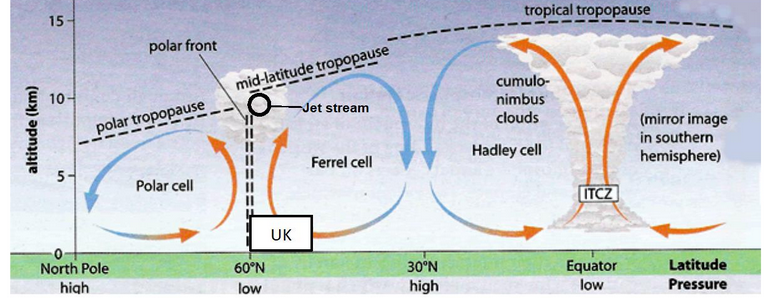
The Jet Stream and the Polar Front:
what is the meeting point of the ferrel cell and polar cell called?
The Polar Front
What is the jet stream?
fast moving high altitude wind called the Jet Stream
caused by:
in the upper troposphere the difference in the temperature of the coolliding cold polar air from the north and the warm tropical air from the south creates the jet stream.
what does the shape and position of the jet stream determine?
the position of the high and low pressure systems.
at what altitude does the jet stream flow?
10km high in the troposphere
what speed and direction does the jet stream flow?
200mph
flows from west to east in the northern hemisphere and the speed of the jet stream depends on the temp difference between the two air masses.
Why does the jet stream flow faster in winter?
because the contrast between the cold polar air and the warm tropical air is the greatest. this can lead to higher wind speed and a stronger jet stream
The changing pattern of the jet stream:
what are the meanders within the jet stream known as?
Rossby waves
what happens to Rossby waves when the flow of air slows down?
they become more extreme
what happens to rossby waves as the air flow increases?
they become less extreme and pronounced
what will the pattern of rossby waves affect?
the position of high and low pressure systems around the UK
what happens if the rossby waves meander more in relation extreme weather events?
if it meanders more, it takes longer for the low/ high pressure systems to move.
this can lead to an increase in extreme weather events
The Polar Front, Frontal precipitation and the Jet Stream:
what does the collision of tropical maritime and polar maritime air lead to?
leads to the formation of low pressure zones where air rises. these zones are known as depressions.
Where air rises through the atmosphere, what will occur?
cooling of air
condensation of water vapour
cloud formation
precipitation
Formation of depressions: STAGE ONE
along the Polar Front, there will be a temperature difference between the colliding air Pm and Tm masses.
where the temp difference is relatively great, uplift will occur, thus creating low pressure at ground level.
formation of depressions: STAGE TWO
Air at ground level will be drawn into this low pressure area to replace that which has been uplifted.
due to the coriolis effect, this air will be deflected as it flows towards the low pressure, creating an anticlockwise circulation of air.
as air starts to rotate it’lll push warm air into cold air and cold air into warm air
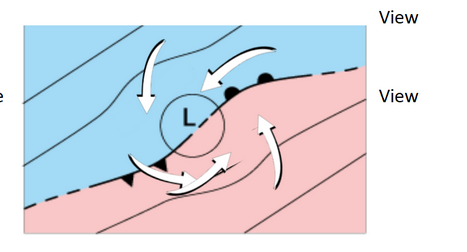
Formation of depressions: STAGE THREE?
Due to anticlockwise rotation of air into the centre of the low pressure the Polar Front develops waves creating an embryo depressions
on the east side of the low pressure, warm Tm air is being forced into the cold Pm air. this creates a warm front as warm air is forced over cold air>
on the west side of the low pressure, the cold Pm air is forced into the warm Tm air. this creates a cold front.
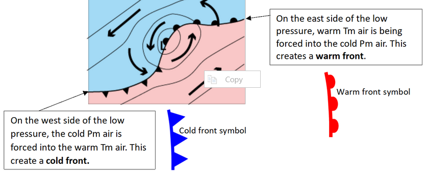
what is a warm front?
A warm front is a boundary in the atmosphere where warm, moist air is forced to rise over colder, denser air.
what is a cold front?
A cold front is a boundary in the atmosphere where cold, dense air pushes under warmer, moist air, causing the warm air to rise rapidly.
what happens along the warm front?
along the warm front, the warm air, being less dense is forced over the cold air and is forced to rise
what happens along the cold front?
cold air is more dense and undercuts the warm air which in turn is forced to rise.
also cold air is stronger than warm air so it pushes underneath the warmer air
The role of the jet stream:
why do low pressure systems regularly form in the North Atlantic Ocean?
due to the warm tropical maritime air passing over the warm North Atlantic Drift Ocean current which provided a lot of warm humid air.
when this air collides with the cold Polar Maritime air, the uplift results in a large amount of condensation and precip.
What happens to the rising air in a depression along the warm and cold front?
it gets drawn into the jet stream which drags the low pressure system in a easterly direction along the polar front.
why does the Uk get alot of rainfall year round and does not have a clear wet and dry season?
this is because, although the position of the polar front and jet stream shift north and south seasonally, because of the Rossby waves, the pattern of precip throughout the year is not predictable.
position of the polar front will shift seasonally as the polar and ferrel cells will shift seasonally