IB Geography Extreme Environments
1/92
Earn XP
Description and Tags
Name | Mastery | Learn | Test | Matching | Spaced | Call with Kai |
|---|
No analytics yet
Send a link to your students to track their progress
93 Terms
Where are cold environments found and what are the common characteristics
High latitudes and altitudes
Polar environments at north and south poles
Periglacial area before polar environment
Also cold environments in high altitude, mountainous areas.
Where are desert and semi-arid environments found and what are the common characteristics
Around the tropics
Stable low pressure conditions and large distance from the sea needed for these areas to form
Arid receive less than 250ml a day, and semi arid between 250 and 500 mm rainfall
What is continentality
The distance of land from the sea. Deserts require a high continentality
Why is it difficult to develop and settle in cold and high altitude environments
Mountains are steep, so difficult to build on
This also limits transport
They also usually have thin, infertile soils which experience high levels or erosion
Periglacial areas usually have waterlogged soils and low levels of evaporation
Also a short growing season due to temperatures being high enough for only a small proportion of the year
Why is it difficult to develop and settle in desert and semi-arid environments
Lack of water
Therefore, as well as high temperatures, agriculture is made difficult
Deserts are at risk of flash floods.
What is the comfort zone
The temperature and humidity range for human habitation. Although may be culturally bias as some indigenous populations are better able to deal with the cold than some other populations
How do indigenous people cope with cold environments
Migratory patterns(moving north during the summer and south in the winter to avoid extreme cold)
The use of fishing in lakes and the sea for food as agriculture and livestock is difficult
How do indigenous people cope with desert and semi-arid
In the middle of the day they take a rest and avoid direct sunlight
They travel in early morning and late night
They wear lose fitting, thin garments to reduce sweating and overheating.
How can farmers cope with water shortages in dry areas
Reducing the size of herds
Exchange of livestock and products to suit drier conditions
Greater use of drought-tolerant species
Use of wild species and crops
Windbreaks to reduce wind erosion of bare soil
Herd diversification
What affects a glacial system
a glacial system is the balance between inputs and output storage
accumulation > ablation = glacier advances (postive regime)
accumulation < ablation = glacier retreats (negative regime)
accumulation = ablation = is steady
Outputs- Ablation, sublimation of ice to vapour and sublimation of ice
wadis
Wadis left over from dried up rivers, they have been eroded through flash floods
river channels steep sided and flat bottomed
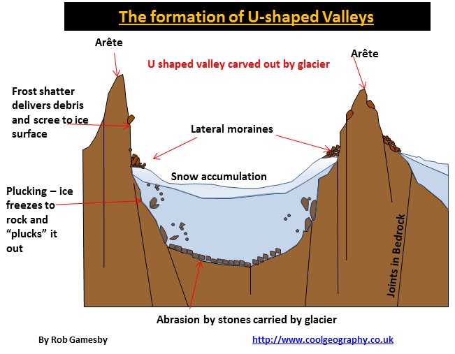
What is plucking
A method of glacial erosion, found at the base of the glacier
As a glacier moves through a valley, pressure is exerted on the sides and bottom of the valley
This generates friction and heat, causing the edges of the glacier to melt a bit \
This meltwater freezes around rocks and stones under the glacier
As the glacier moves forward, it 'plucks' this ice, pulling the rock away
once rock moved out, and apart of ice can be used for abrasion now
What is abrasion
A method of glacial erosion
Debris carried by the glacier scrapes and scratches rock, leaving striations
The amount/rate of erosion depends on, local geology, velocity of the glacier, weight and thickness of the ice, and the amount of load carried
How are cirques/corries formed
an amphyteatre shaped valley, scooped out by erosion
A pre-glacial hollow is enlarged by freeze-thaw and removal of snow melt
Ice accumulates in the hollow
ice moves through gravity, rotational slip, eroding the floor though plucking and abrasion
Freeze-thaw, plucking and abrasion further erode the hollow into a rounded, steep-sided 'armchair' shape with a lip at the bottom end
How are aretes formed
An arête is a knife-edge ridge. It is formed when two corries run back to back. As each glacier erodes either side of the ridge, the edge becomes steeper and the ridge becomes narrower.
What is the different between glacial drift and till
and what is glacial deposits
deposits are dropped by retreating or stagnant glaciers
Drift- glacial and meltwater deposits left after the ice has melted
Till- Angular, unsorted glacial deposits
What are the characteristics of Till
Poor sorting- it contains a large range of rock sizes
Poor stratification- No regular sorting by size
Mixture of rick types
Many particles have striations
What are erratics
a form of glacial deposition
random rocks of different sizes and types from the area where they are found, thsu the material can be used to trace back origin
What is moraine
Lines of loose rock
At the snout of the glacier there is a crescent shaped mound called terminal moraine
Lateral moraine is at the ridge or on the edge of a glacier
Where two glaciers merge and the two lateral moraines flow in the middle of the enlarged glacier, it is medial moraine
What is freeze thaw weathering
Freeze-thaw occurs when water continually seeps into cracks, freezes and expands, eventually breaking the rock apart.
happens over a long time
What is frost heave
When ground ice forces soil or small stones to the surface, frost heave occurs
What is solifluction
flowing of soil.
In winter water freezes in the soil causing expansion of the soil and segregation of individual soil particles.
In spring the ice melts and water flows downhill. It cannot infiltrate the soil because of the impermeable permafrost.
As it moves over the permafrost the soil becomes separated and are spread downslope
creates solifluction lobes and terracettes, forcing soil to heave upwards towards surface
What is patterned ground and how is it formed
A general term describing the stone circles, polygons and stripes which are found in soils which are subjected to intense frost action.
the result of frost heave, solliflcuction, and vegetation
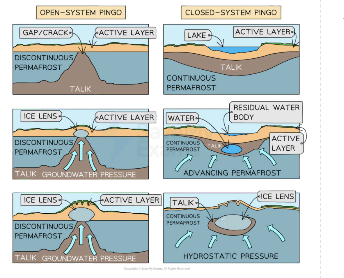
What is a pingo
An isolated, conical hill which is found in periglacial environments. They are formed by the movement and freezing of water under pressure.
Open system pingo - Formed when the source of water is from a distant, elevated source.
Closed system- pingo Formed when the water is local, and the pingo is formed due to the expansion of permafrost
What is thermokarst
Wet hollows caused by subsidence due to the melting of permafrost. This can be due to
cyclic changes in vegetation which may affect albedo
Shifting of stream channels which may affect the amount of heat affecting permafrost
Fire
What are the 3 types of permafrost
must be frozen in the ground for at least 2 years
Continuous, large, unbroken stretches of permafrost
discontinuous, mostly permafrost, with some small, unfrozen ground (talik)
sporadic, where small patches of frozen ground occur
The active layer of permafrost is found at the surface and it thaws out seasonally
What is salt crystallisation in hot arid environments
In areas with diurnal temperatures, salt expands in rock, outwards pressure and rock cracks.
when water evaporates, leaving behind salt crystals, as temp rises slat expands exerting pressure, and rock cracks
What is disintegration in hot arid environments
Found where there is a large diurnal temperature range. Rocks heat up during the day, and contract at night, as heat is released. This causes exfoliation of the outer layers of the rock, cracksmoisture is essential for this process.
What are the 3 types of river in hot arid environments
Exotic- comes from a different climate zone
Endoreic- Flows to an inland basin
Ephemeral- seasonal
What is deflation as a mode of wind erosion in hot arid environments
The progressive removal of small material, leaving behind larger materials. Forms a stony desert. In some cases, defaltion may remove sand to form a deflation hollows
rocks too heavy to be transported are called ventifacts
What is abrasion as a mode of wind erosion in hot arid environments
Erosion carried out by wind borne particles. They act like sandpaper, smoothing surfaces.
if rocks are homogenous - wind smooths surface
if rocks are heterogenous, weakend by faults, forming natural rock pedestals as rock face is etched
How can agriculture in hot, arid areas become more sustainable
Using drought-tolerant crops/fodder for livestock
Reducing herd size to reduce pressure on vegetation
Using animal dung as fertiliser
Building small scale dams
Using efficient forms of irrigation, such as drip irrigation
What causes soil infertility in hot arid environments
Low organic content due to limited biomass
Being thin
Lacking in clay
Salinisation which reduces water uptake of plants
Why is mineral extraction in hot arid environments difficult
Most areas are very remote so transport is difficult and expensive
Housing and basic utilities need to be provided
Water shortages may require desalination
Why are periglacial areas or tundra areas fragile
The ecosystem is highly susceptible to human impact due to the limited species involved
The very low temperatures reduce decomposition
Pollution has a very long lasting effect
soils are frequentlyw aterlogged, as low temp thsu low evaporation rates
Permafrost is disrupted by heat
What is desertification
The spread of desert like conditions into previously productive areas. Can be caused by overgrazing and deforestation
What are the consequences of desertification
Environmental
Loss of soil nutrients through wind and water erosion
Changes in composition of vegetation and loss of biodiversity as vegetation is removed
Reduction in land available for crop growth
Economic
Reduced income from pastoralism and food crops
Decreased availability of firewood, necessitating the purchase of oil
Increased rural poverty
Social and cultural
Loss of traditional knowledge and skills
Forced migration due to food scarcity
Social tensions in reception areas for migrants
What are the strategies for preventing desertification
Reducing overgrazing by improving stock quality using vaccination, and better yield varieties
Overgrazing can also be managed by better management and reduced herd sizes
Reducing over cultivation can be achieved by using higher yield varieties, fertilisers, and irrigation.
Finally reducing deforestation is done by social foresting, alternative fuels instead of using firewood, and agroforestry (where farmers continue cropping but use trees to provide shade and fertilise the soil.
through water management, of drip irrigation, earth dams used in wet seasonto store water
eduactaion about sustainable farming techniques, agroforesty and crop rotation
What are the environmental effects of climate change in extreme environments
Falling crop yields and rising food insecurity, increased water stress, flooding of low lying areas. Spread of diseases eg. Malaria
Conflict over resources eg. water and pasture. Loss of territory and border disputes, forced migration causing urban overcrowding. Tension over energy supplies
What are some coping strategies for climate change in extreme environments
Improving soil fertility by the careful use of fertilisers
Using indigenous plant species
Improving efficiency of irrigation systems and pest control
Adopting water and soil conservation techniques using stone rows to reduce run-off on slopes
What are some advantages and disadvantages of climate change in extreme environments
Disadvantages
Unpredictable sea ice provides issues for Inuits
More shipping mining and oil and gas exploration may threaten the environment
Advantages
Farming may become more productive as the growing season will extend
Forestry in some areas may become possible
Tourism in cold environments may become more popular
how are pyramidal peaks formed
a three-sided, pointed mountain peak
A pyramidal peak is formed where three or more corries and arêtes meet. Glaciers erode backwards towards each other, carving out the rocks by plucking and abrasion. Freeze thaw weathers the top of the mountain, creating a sharply pointed peak.
natural causes of desertification
Soil erosion leads to the loss of nutrients. Plants are unable to establish and grow
Rainfall patterns have become less predictable, leading to drought and any vegetation dying due to lack of water
Reduced vegetation means that nutrients are not added to the soil through the decomposition of dead organic matter
Any rain that does fall is often in short, intense bursts, leading to increased surface run off and soil erosion
human causes for desertification
Population growth puts increased pressure on the land as people raise more animals and grow more crops
Deforestation removes shade for the soil and means there are no roots which bind the soil together. This increases soil erosion, whilst decreasing infiltration and interception
Over-cultivation leads to all the nutrients being taken up by crops, leaving none for future vegetation to grow
Overgrazing means the vegetation has all gone due to the numbers of animals or the land does not have chance to recover
case study of desertifcation in kenya
in Kenya
Nomadic Masai farmers have been forced to use smaller and smaller areas of land for grazing. This results in overgrazing, which removes the vegetation. The soil no longer has protection from the wind and rain, which leads to soil erosion and desertification
Population growth increases the demand for food and fuelwood. This leads to over-cultivation and deforestation, reducing the amount of nutrients returned to the soil.
Exposes the soil to wind and rain This further increases soil erosion, leading to desertification
In Kenya increasing temperatures and more irregular rainfall are natural causes of desertification. However, these could be the result of the enhanced greenhouse effect (human cause) leading to climate change
land degredation
Land degradation indirectly affects about 350 million people in the developing world
Land degradation occurs through changes in soil character, wind erosion, or water shortages (droughts), which leaves the land unproductive or lost
what is affroforestry
Tree planting, such as the Great Green Wall across the Sahel, helps to reverse desertification in several ways:
The roots help to bind the soil together, reducing soil erosion
The canopy offers shade, helping to prevent the soil from drying out and also reducing soil erosion from rainfall landing directly on the soil
Falling leaves and branches replace nutrients in the soil
The trees increase animal and insect activity, which helps improve soil quality
example of indigenous displacement Siberia
In northern Siberia, the Yamal Peninsula is a remote, windblown tundra region, with largest natural gas reserve.
The Indigenous Nenets are nomadic reindeer herders that have used the Yamal Peninsula for over 1 000 years. They graze reindeer in the north during the summer and migrate south for the winter Due to climate change and oil and gas exploration, the Nenets are under threat Russia intends to exploit the region, putting the future of nomadic herding at considerable risk
role of TNC’s
In places such as Sudan, Egypt, Mali, and Uzbekistan, there are financial pressures because big companies are willing to pay large sums of money to buy land to grow cotton to sell abroad
what is desalitantion
the process of removing salt from seawater to make it drinkable, through reverse osmosis or distillation. It is very expensive to build and maintain
example of sustainable housing
in New Mexico, Earth-ship homes, they are passive solar homes made from natural and recyclable materials that are designed to be 'off-the-grid' and consume no fossil fuels or energy.
they are natuarally insulated through walls made of thick mud bricks.
The homes are oddly shaped to maximise solar energy In winter, sun-facing windows provide heat, while in summer they are shaded.
case study sweden
Sweden is a heavy consumer of energy due to its development and cold climate, however, it has some of the lowest carbon emissions of any developed country.
Sweden has invested money into renewable energy sources like solar and wind power, more than half of its energy from clean sources such as wind, sun, and water 95% of these green energy sources come from hydroelectricity, but solar and wind power are becoming more important
irrigation in hot arid environments
Irrigation is typically used to support natural rain fall, but a regular water supply is hard to come by in hot, arid areas
high temperatures and strong sunlight cause water to evaporate quickly, adding to water scarcity
salinisation
Salinisation is where intense evaporation at the soil's surface encourages soil moisture and minerals to rise
This leaves the soil with a high pH value
When irrigation water is added to the land and allowed to evaporate, this increases the effect of salinisation
Increased soil salinity restricts most plant growth by reducing water uptake by plant roots Some crops are more salt-tolerant than others and are called halophytes
Palm dates and cotton are halophytic
land owenership
Land ownership disputes can arise between indigenous populations, government entities, and private companies. For areas that rely on farming as their main source of income, land ownership is important for families to succeed and survive
benefits in cold environments
Valuable minerals are found in many cold environments, such as nickel, gold, iron ore and diamonds in northern Canada and coal, tin and uranium in Russia
abaundance of gas and oil
Wilderness and adventure tourism to extreme cold environments is a growing industry for countries and local communities
however, does increase polltuion and demand fro energy and resources
challenges in cold environments
Building roads, railways and pipelines for water and electricity supplies is very difficult on frozen ground that is liable to melt
Homes are raised on stilts to prevent their heat from melting the permafrost, which can cause the land to sink and subside)
The rugged and mountainous terrain make these areas inaccessible for vehicles to deliver goods and materials for development and day-to-day living
resource nationalism
thee assertion of control by people and governments, for strategic and economic reasons, over natural resources located on their territory
opportunities in hot arid environments
energy:
Solar energy in areas such as the Mojave, Desert
Wind, including the Tarfaya complex in the Sahara Desert
Coal mining, such as the Thar coalfield
Reserves of a range of minerals include copper, uranium, and coal in
large tourism, however can disturb local cultures, such as drinking, pressure on resources
challenges in hot arid environments
the lack of available water, also due to extreme temperatures reaching 50 degrees
The abundant stores of natural resources can lead to political tensions over contested land or borders
case study Thar desert
between Pakistan and India
opportunities:
The construction of the Indira Gandhi canal allows irrigation
Tourists are attracted to seeing the different species found in the deserts on desert safaris
extraction of minerlas such as limestone and phosporus
The Jaisalmer Wind Park is the world's fourth-largest wind farm
Challenges
hot temperatures of 50 degrees
precipitation very low and high evaporation
low road accessibility, and tarmac may melt due to temp
rotational slip
Ice advances in a circular motion called rotational slip, which hollows and deepens the landscape
glacial till
Any material carried or moved by the glacier
U shaped valley
Glacial troughs are steep-sided valleys with a flat floor
They start as V-shaped river valleys but due to the size and weight of the glacial ice, it changes to a U shape as the glacier erodes the sides and bottom, making the valley deeper and wider
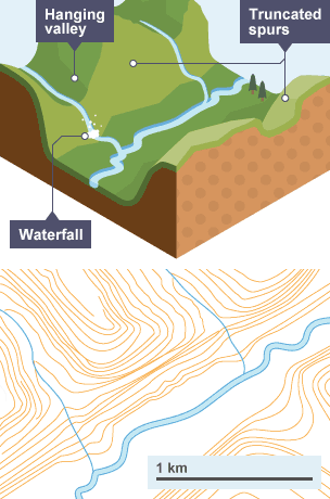
Hanging Valley
These are small tributary glaciers found 'hanging' above the main valley floor When melting occurs, there are waterfalls onto the valley floor

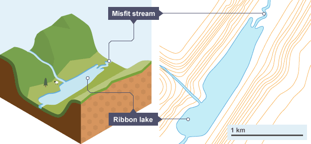
ribbon lake
As a glacier flows, it travels over hard and soft rock Softer rock is less resistant to erosion, so a glacier will carve a deeper trough over this type of rock When the glacier has melted, water collects in these deeper areas This creates a long, thin lake called a ribbon lake
Truncated spur
Truncated spurs are past interlocking spur edges of past river action that have been cut-off forming cliff-like edges on the valley side
Found between hanging valleys and are an inverted 'V' shape formed when the lower valley glacier cuts off previous ridges or spurs as it passes by
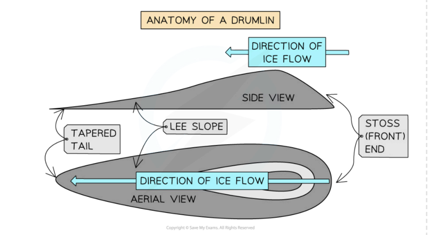
drumlins
Drumlins are elongated, egg-shaped hills made of glacial till
they are deposited as a result of friction between the ice and the underlying geology, causing the glacier to drop it’s deposits. as the glacier continues to advance the shape os formed, lee side is direction of ice
what is the difference between periglacial and glacial environment
altered by ice
periglacial; within the ground
glacial; above the ground
landforms are created through
periglacial: freeze-thaw weathering and mass movement
erosion and deposition
found
periglacial:outer margins of cold environments
glacial: high altitudes and latitudes
thaw lakes
meltwater cannot drain through the impermeable permafrost below and sits on the surface as thaw lakes
Thaw lakes are common in these poorly drained areas and as the water continues to absorb solar radiation, so the depth and size of these lakes increase in size
pressure exfoliation
This is where overburden is removed through weathering and erosion and the rock beneath is gradually exposed
The removal of the weight of the overburden releases the pressure on the rock beneath and the outer layer splits/fractures apart
Once fractures develop, water enters and chemical weathering takes place, leading to the formation of new low-density minerals
wind transportation 3 types
Creep occurs when sand grains slide and roll across the surface
Saltation occurs when the wind is strong enough to bounce particles close to the ground
Material moved by saltation may move around and push bigger particles that are too heavy to lift. They do not travel too far because tehy are heavy
Suspension occurs when high-speed winds carry small dust particles (fine silt and clay) into the atmosphere
main cause of dust storms
water action in hot arid environments
Rainfall is sporadic:
from flash floods, although short-lived, huge amounts of sediment are washed down from the mountains and deposited on alluvial lowland plains
Rain is able to hit the surface hard, moving small particles around and covering soil pores, which slows the rate of infiltration even further
sheetwash processes
Sheetwash erosion is a form of surface runoff critical in the transportation of soil sediments. This thin layer of water flows over the ground surface, rather than a distinct chanel
The flow possesses enough force to detach soil particles and transport them.
Sheetwash can move finer particles, including silt and clay, over considerable distances, depending on the flow's intensity.
yardangs
created through wind erosion
looks like an upturned boat
the softer rock strata is removed , leaving more resistant rock layer
long ridges where the strata is vertical

zeugens
formed through wind erosion
Zeugens form in the same way as yardangs, but the layers of resistant and less resistant rock lie horizontally
mushroom shaped
pedestal rocks
Thought to be the final remains of a zeugen, they are again primarily formed as a result of abrasion
It can also be found in areas where isolated rock peaks are exposed to the surface
Winds carrying fine sand particles act as an abrasive and start cutting and polishing the exposed rock
Continued erosion leads to the eventual collapse of the pedestal

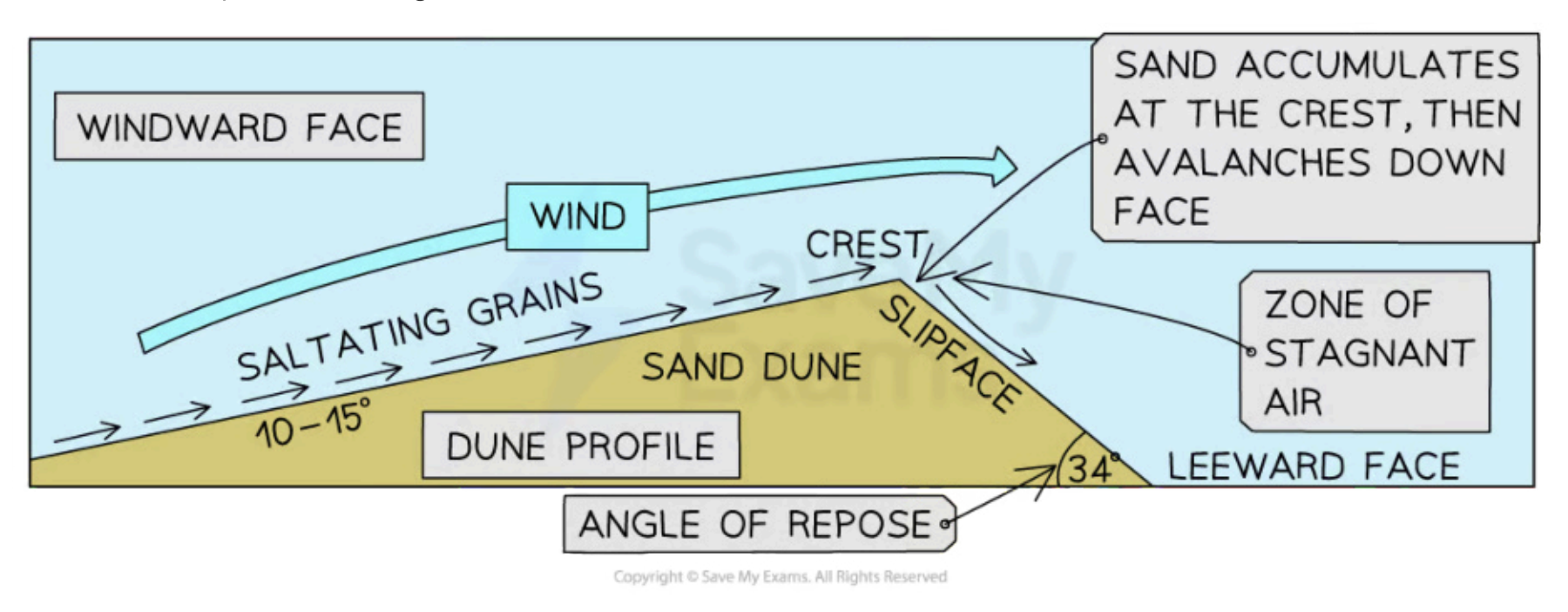
sand dunes
They are the consequence of saltation
hte transport of hard particles over an uneven surface in a turbulent flow of air or water.
Dunes grow as sand particles move up the gentle, windward slope, by the processes of saltation and surface creep
The sand particles continually fall over the crest of the dune, onto the steeper, slightly concaved, leeward slope/slip face
The top of the slip face is steep because it is made of fine-grained sand and it is kept steep by wind eddies
The bottom of the slip face is gentle, contains coarse-grained sand and may have further sand ripples
canyons
Canyons are deep gorges that usually have a river running through them
Canyons are formed over millions of years when water rushes through any kind of rock, but especially sandstone and limestone
formed through DUDE
D: deposition of sediment from rivers builds up layers of sedimentary rock
U: uplift, the newly formed rock layers undergo uplift, where they rise up and form large plateaus
D: downcutting, hydraulic action deepens the channel of a stream or valley by removing material from the stream's bed or the valley's floor
E: erosion (not wind), erosion wears away at the sides of the plateaus and forms steeper gradients
rain shadow effect
A rain shadow is a patch of land that has been forced to become a desert because mountain ranges blocked all plant-growing, rainy weather. On one side of the mountain, wet weather systems drop rain and snow (windward side). On the other side of the mountain—the rain shadow side—all that precipitation is blocked (leeward side)
whata re factors effecting glacial abrasion
ice thickness, more thick greater pressure, more effective abrasion
hardness of bedrock, harder = better
sliding of ice, the faster the better
frost creep
it is a type of solifluction, occurs because of frost heaving and thawing.
the freezing of the surface lifts particles up at right angles to slope,
as ice thaws the particles drop in elevation with the surface
some partciles move slightly downslope due to gravity
Alluvial fan
cones of sediment deposited by rivers
different types of river flow in desserts
Exotic/ exogenous
the source is another wetter environment, nile
Endorheic
rivers that drain into an inland lake or sea
Ephemeral
rivers that flow seasonally or after storms
butte
isolated peak, remnant of mesa or plateau, water has eroded most of rock
Mesa
quite large plateau with steep sides, isolated from plateau due to erosion or slope retreat
salt pans, playas
sites of formal or occasional lakes
oasis
formed when the water-bearing rocks are exposed at the surface, done by deflation
barchan or crescent dunes
sand dunes formed when wind speed is high and constant and limited supply of sand
they are u shaped
pediment
shallow slopes formed at the base of a cliff or a steep hill
arroys
channels that ave been enlarged by repeating floods
ANWR
Artcitic National Wildlife Refuge,
largest protected wildlife area in USA, 9 million hectares in north east Alaska
oil companies want to drill for oil
Greenland case study
in 2014, at the cusp of resource boom due to melting ice, discovering traces of oil underneath their ice.
many companies wanted to take over, but harsh waters and isolated living. Further the oil collapse in 2014, restricted countries development, still dependent on Denmark