A Level Edexcel Water Cycle Enquiry Question 1
1/57
There's no tags or description
Looks like no tags are added yet.
Name | Mastery | Learn | Test | Matching | Spaced | Call with Kai |
|---|
No analytics yet
Send a link to your students to track their progress
58 Terms
[5.1A] What is the global hydrological system and why is a closed system?
It is the circulation of water around the earth, and it is a closed system as there are no external inputs or outputs, so the amount of global water is finite and constant. The water can exist in different states within the closed system.
[5.1A] How is the hydrological cycle driven?
It has two sources, solar energy in terms of heat from the sun causes changes in the state of water, and drives some of the processes within the cycle. The second source is gravitational potential energy which causes the movement of water, such as precipitation falling down, and rivers to flow downhill.
[5.1A] What are inputs and outputs in the hydrological cycle?
Inputs:
- The movement of matter into a system, however, this is done internally for the hydrological cycle into a store only, as it has a closed system.
Outputs:
- The movement of matter out of a system, however, this is done internally for the hydrological cycle, so the movement out of a store into another store.
[5.1A] What are stores and flows?
Stores:
- Stores are reservoirs where the water is held, e.g the ocean.
Flows:
- Flows are the transfers of water from one store to another.
[5.1B] What are fluxes and processes?
Fluxes:
- Fluxes are the rate of flow between stores.
Processes:
- The physical mechanisms that drive the fluxes of water between the stores.
[5.1B] What are the main stores of water and what percentage of water is stored in these stores?
- Oceans (97%)
- Cryosphere (Glaciers and ice sheets) (1.9%)
- Groundwater (1.1%)
- Rivers and lakes (surface water) (0.01%)
- Soil moisture (0.01%)
- Atmospheric moisture (0.001%)
[5.1B] What is the cryosphere?
The areas of earth where water is frozen into snow or ice.
[5.1B] What are examples of flows?
Oceans and Atmosphere:
- Evaporation and Precipitation.
Atmosphere and Land-based Stores:
- Evaporation and Precipitation.
Land-based and Ocean Stores:
- Surface run-off.
[5.1B] What might cause increased fluxes?
Industrialisation:
- Greater demand for water.
Seasonal Temperature:
- Winter will increase volume of water in cryosphere.
- Summer will increase evaporation, and thermal expansion.
Climate Change:
- More evaporation and cryosphere melting.
[5.1C] What does residence time mean?
The average amount of time one water molecule stays in a particular store (days/months/years).
[5.1C] What is the global water budget?
This takes into account all the water that is held in stores and flows of the hydrological cycle.
[5.1C] What is fresh water and how much of the world's water budget is it?
Water that doesn't have much dissolved in it e.g. salt. It's around 2.5%, and around 1% is not accessible due to being in glaciers and ice caps.
[5.1C] What is fossil water?
Fossil water is ancient, deep groundwater made from pluvial (wetter) periods in the geological past. This is non-renewable.
[5.1C] How does the global water budget limit human use?
- With much of it being inaccessible, or not freshwater, or not renewable, it limits human use of water stores. Additionally, many have long residence times in stores, meaning sometime sourcing it can be difficult.
- The water budget determines what is available because some regions have more precipitation than others, and rivers and lakes, or groundwater.
- Some water sources are not replenished.
[5.2A] What is a drainage basin?
This is known as an open subsystem within the closed system of the global hydrological cycle. It is defined as an area of land drained by a river and its tributaries, also known as the catchment. The boundary of a drainage basin is defied as the watershed, which is usually a high ride of land which divides and separates water.
[5.2A] Why do drainage basins vary in their size and capacity?
- The topography of the land, so more hills will equal smaller drainage.
- Flatter area will mean a larger drainage basin.
- Deep soil can influence capacity, meaning there is more permeable rock which stores water through percolation.
[5.2A] What is the main input in the hydrological cycle, and what are the types?
Precipitation - rain, snow, sleet, and hail.
[5.2A] What factors can influence the drainage basin?
Form, amount, intensity, seasonality, and distribution.
[5.2A] How can the form, amount and intensity of influence the drainage basin?
Form (Type):
- Is it snow, rain or hail? With snow, the entry of water into the drainage basin will be delayed.
Amount:
- This can have a direct amount on the discharge of the drainage system. It will impact the amount of water within the drainage system.
Intensity:
- The greater the intensity, the greater the likelihood of flooding, as infiltration is more difficult if soil capacity is exceeded. Impacts flows.
[5.2A] How can the seasonality, and distribution of precipitation influence the drainage basin?
Seasonality:
- In some climates, such as monsoon and Mediterranean, there are strong seasonal patterns of rainfall. This means the time of year determines the precipitation input within the drainage basin. This will influence flows at different time of the year.
Distribution:
- The distribution of precipitation within a basin. The impact is particularly noticeable in very large basins.
[5.2A] What are the types of precipitation?
Convectional, frontal, and orographic.
[5.2A] How does orographic rainfall form?
1. When warm, moist, west prevailing windows forces air over a barrier, such as a mountains.
2. This causes the air to cool, causing it to condense which consequently causes rain and clouds.
3. The leeward (downwind) slope receives relatively little rain, which is known as the rain shadow effect.
*leeward - towards the side sheltered from wind.
[5.2A] How does convectional rainfall form?
1. This occurs mostly in summer, as the first step is caused by the earth's hot surface which heats the air above, causing the air to become warmer and expand, consequently rising.
2. As the air rises, it cools, causing condensation. This forms clouds.
3. Further ascent of the air will cause it to rain.
4. The cool air descends and replaces the warm air.
[5.2A] How does frontal rainfall form?
1. The warmer air, which is lighter and less dense is forced to rise over cold, denser air when undercut by the colder air.
2. As it rises, the air cools and it struggles to hold water vapour.
3. Condensation occurs and clouds form, which later causes rain.
[5.2A] What are examples of flows in the hydrological cycle?
Interception, infiltration, surface runoff, saturated overland flow, through flow, percolation, and groundwater flow.
[5.2A] What's interception?
The retention of water by vegetation which is subsequently evaporated or absorbed.
[5.2A] What's infiltration?
The process of which water is absorbed by the soil.
The rate is influenced by:
- Soil composition.
- Previous precipitation, so whether the infiltration capacity has been met.
- The relief of the land, as if it's a slope, infiltration will be reduced.
[5.2A] What's percolation?
This is similar to infiltration, but a deeper transfer of water into permeable rocks.
[5.2A] What's through flow?
The lateral (horizontal) transfer of water downslope through the soil.
[5.2A] What's groundwater flow?
The very slow transfer of percolated water through permeable or porous rocks.
[5.2A] What's surface run-off?
This occurs when the soil may be too saturated so more water can't infiltrate, or the rock is impermeable so the water moves across the surface.
[5.2A] What's overland flow?
It is the water that runs across the land after rainfall. This is due to the soil being too saturated. Not much different to surface-run off.
[5.2A] What are examples of outputs within the hydrological system?
Evaporation, transpiration, and channel flow.
[5.2A] What's evaporation?
Evaporation is the process by which moisture is lost directly into the atmospheres from water surfaces, soil and rock due to solar energy.
[5.2A] What is transpiration?
The diffusion of water from vegetation into the atmosphere, involving a change from a liquid to a gas.
[5.2A] What's discharge (channel flow)?
Water being outputted into another drainage basin, a lake or the sea.
[5.2A] What's evapotranspiration and potential evapotranspiration?
Evapotranspiration (EVT):
- This is the combined effect of evaporation and transpiration. It represents the most important aspect of water loss to the atmosphere.
Potential evapotranspiration (PEVT):
- This is the water loss the would occur if there was an unlimited supply of water in the soil for use by vegetation.
[5.2B] What physical factors influence inputs, flows, and outputs?
Climate, soils, vegetation, geology, and relief.
[5.2B] How does climate, soil and geology influence inputs, flows, and outputs?
Climate:
- This influences amount of precipitation and evaporation.
- The more precipitation, the greater surface run off.
- It also affects the vegetation growth.
Soils:
- The soil composition can influence the rates of infiltration and through flow.
- The soil indirectly determines the vegetation.
- This all impacts interception, and surface run-off.
Geology:
- This can impact subsurface processes, such as percolation, and groundwater flow.
- Indirectly affects soil formation.
[5.2B] How does relief and vegetation influence inputs, flows, and outputs?
Relief:
- The steeper the gradient of topography will encourages faster rates of surface run off.
- The steeper the gradient can encourage orographic rainfall.
Vegetation:
- The presence or absence of vegetation has a major impact on the amount of interception, infiltration, and occurrence of overland flow, as well as on transpiration rate.
[5.2C] How do human factors disrupt the drainage basin?
They accelerate processes through a number of way, including groundwater abstraction, formation of storage reservoirs, deforestation, and changing land use.
[5.2C] How does deforestation and changing land use disrupt the drainage basin?
Deforestation/Afforestation:
- This leads to less vegetation, causing less interception, and therefore more surface run-off. This could lead to more flooding, speeding up the cycle.
- Reduction in evapotranspiration.
- It is the opposite for afforestation.
Changing Land Use:
- This is usually for agricultural purposes.
- The conversion to farmland can reduce vegetation, and make soil more compact by livestock and tractors.
- Can make the land less compact from ploughing.
- This leads to less infiltration, and more surface-run off.
- Urbanisation is included in this, with the creation of impermeable surfaces, leading to more run-off, and greater channel flow. Drains exacerbate this.
[5.2C] How does ground water abstraction and the formation of storage reservoirs disrupt the drainage basin?
Groundwater Abstraction:
- When water is taken out faster than the water is recharged, groundwater flow decreases and the water table drops.
- This is for domestic, industrial, and irrigation use.
Storage Reservoirs:
- This prevents channel flow due to water is kept behind dams. This reduces river discharge downstream, and creating an evaporation source.
[5.2C] How has Amazonia been affected by deforestation issues?
- Over 20% of the forest has been destroyed.
- Contains 60% of the world's rainforests, so the environmental impact on global life support system is to the highly significant.
Affected the drainage basin through:
- Less precipitation.
- More surface run off and infiltration.
- More evaporation, less transpiration.
- More soil erosion.
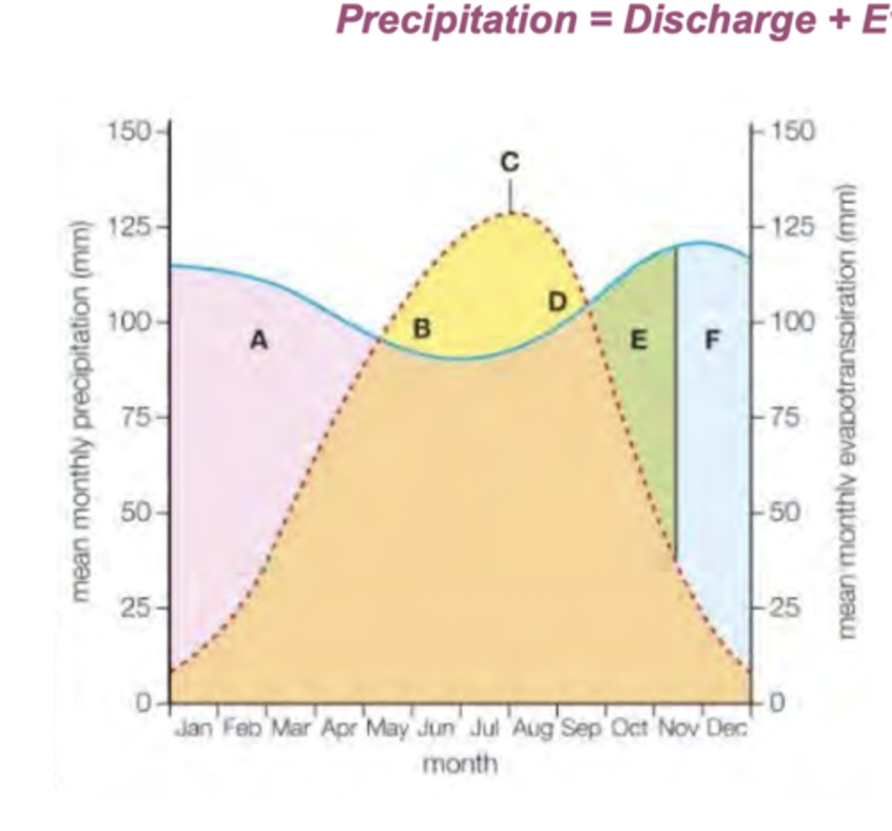
[5.3A] What is a water budget, and how is worked out?
A water budget is the balance between precipitation, evapotranspiration, and run-off. It indicates the amount of water that is available for human use.
Formula:
- P = Q + E +/- S
P = Precipitation, Q = Discharge, E = Evapotranspiration, S = Changes in Storage.
[5.3A] What does A, B, C, D, E , and F mean on this water budget diagram?
A:
- Precipitation is greater than evaporation, therefore the soil's moisture increases, creating a soil moisture surplus.
B:
- As temperatures increases, the rate of evaporation will increase. The soil uses the moisture gained during its surplus, through soil moisture utilisation.
C:
- The point of maximum evaporation. This is the point of highest risk of drought.
D:
- Despite evaporation decreasing, there isn't enough precipitation to provide for vegetation use. This creates a soil moisture deficit.
E & F:
- As precipitation exceeds evaporation rates, the soil will regain moisture and reduce its deficit through soil moisture recharge,
[5.3B] What is a river regime?
This is the annual variation in discharge or flow of a river at a particular point, usually measured in cumecs.
[5.3B] What factors influence a river regime?
Size of the river, the amount, seasonality, and intensity of the precipitation, temperatures, geology and soils, amount and type of vegetation cover, human activities.
[5.3B] How can the size of the river, the amount, seasonality, and intensity, and temperatures influence the river regime?
Size of the River:
- The size of the river where measurements are taken in the basin: many large rivers have very complex regimes resulting from varied catchments.
The amount, seasonality, and intensity:
- Regimes often reflect rainfall during rainy seasons.
- Some areas are wet or dry, this can cause difference in discharge.
Temperatures:
- Evaporation will be greater in higher temperatures, meaning discharge will be lower.
[5.3B] How can geology and soils, the amount and type of vegetation cover, and human activities influence the river regime?
Geology and Soils:
- The permeability and porosity of geology and soils will influence whether groundwater in permeable rocks is gradually released into the rivers as base flow.
The amount and type of vegetation cover:
- Wetlands can hold the water and release it very slowly into the system.
Human Activities:
- One major change is the building of dams which regulate a river's discharge.
[5.3C] What is a storm hydrograph?
Unlike river regimes which are usually graphed over a year, storm hydrography show discharge changes over a short period, normally a few days.
- This represents the variation in discharge within a short period of time (days, rather than years).
- They plot two things, occurrence of a short period of rain over a drainage basic and the subsequent discharge of a river.
[5.3C] What are the main features of a hydrograph?
Rising limb:
- Once the rainfall input begins, the discharge starts to rise.
Peak discharge:
- This is eventually reached some time after the peak rainfall because the water takes time to move over and through the ground to reach the river.
Lag time:
- Time interval between peak rainfall and peak discharge.
Falling limb:
- Once the input of rainwater into the river starts to decrease, so does the discharge.
Base flow:
- Eventually, the river's discharge returns to its normal level.
[5.3C] How does urbanisation affecting the shape of storm hydrographs?
- Construction work leads to the clearing of vegetation cover, thereby exposing the soil and increases overland flow.
- Bare soil is eventually replaced by impermeable surfaces such as concrete increasing surface run off.
- High density of buildings means rains fall on roofs and is dispatched into drains.
- Drains and swears reduce distance that storm water must travel before reaching a challenge.
- Urban rivers often channelised with embankments to guard against flooding. When floods occur, they can be more devastating as the river overtops in a very confined space.
[5.3C] What physical factors shape storm hydrographs?
Soil and Rock Types:
- Impermeable types cause more surface run off, and a rapid increase in discharge.
Local Relief of Land:
- Steep slopes increase surface run-off and speed up through flow, shortening the lag time.
Vegetation Cover:
- Lack of natural vegetation cover reduces interception and reduces lag time.
[5.3C] What are the characteristics of a 'flashy' river hydrograph?
- Short lag time, high peak, steep rising limb.
- Intense storm that exceeds infiltration capacity.
- Impermeable surfaces.
- High, steep slopes.
- Small basins.
- Low levels of vegetation.
- Lots of human activity, urbanisation and deforestation.
[5.3C] What are the characteristics of a 'flat' river hydrograph?
- Long lag time, low peak, gently sloping rising limb.
- Steady rainfall that is less than the infiltration capacity.
- Permeable surfaces.
- Low, gentle slopes.
- Larger basins.
- Much more cover of vegetation.
- Low population density, not much impermeable surfaces.
[OTHER] What's blue water?
The water stored in rivers, streams, lakes and groundwater.
[OTHER] What's green water?
The water stored in the soil and vegetation.