Physical Geography Exam 2 Notes: Hydro + Atmo + Biosphere
1/67
There's no tags or description
Looks like no tags are added yet.
Name | Mastery | Learn | Test | Matching | Spaced |
|---|
No study sessions yet.
68 Terms
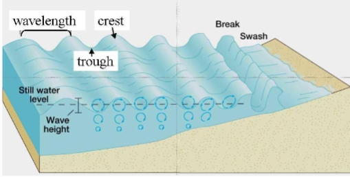
Waves
undulations of water
transmitted from particle to particle
carrying energy from one place to another
caused by friction between wind & ocean surface
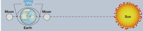
Tides
daily oscillations in sea level
caused by gravitational pull of moon & sun
Spring tide
maximum tidal range
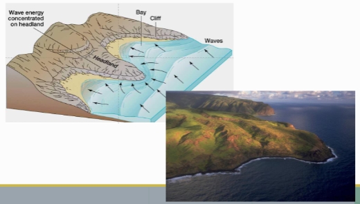
Straightening
A coastal erosion in which waves bend around headland and wear it down
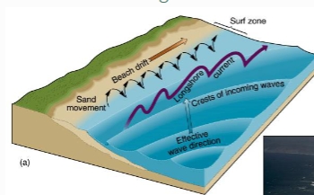
Beach Drift
A coastal erosion which is a movement of particles along the beach

Longshore current
A Coastal erosion movement in which the current is/moves parallel to the beach
Barrier formations
long, narrow dispositional features
usually sand, offshore and parallel to coast
act as a barrier to storm energy
shift position in response to wave action & longshore current
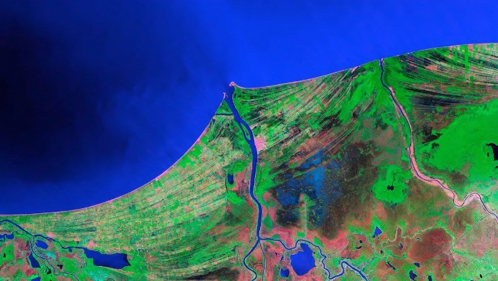
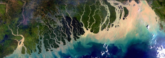
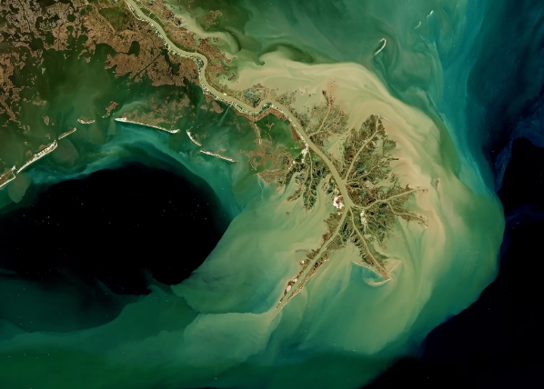
Delta
river meeting an ocean
either river, wave or tide dominated
If channel backfills w sed → can super-elevated relative to its banks + avulse (jump banks and flow somewhere more downhill)
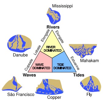
Rio Grivalja, Mexico Delta
smoothness of the coastline — wave-Dom Delta
Ganges Brahmaputra Delta
if tide goes up → water pushes up to the rivers
if tide goes down → water pushes down toward ocean
THUS, tidal-Dom Delta
Mississippi Delta
River primarily controls sedimentary dispensary
THUS, river-Dom Delta
Relative sea level =
Eustatic + Isostatic + Tectonics + Local effects
Tectonics
Lifts land (dec. relative sea lvl) or sink land (inc relative sea lvl)
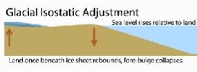
Isostatic (ice sheet)
ice mass depresses land below, displaces nearby land UPWARD creating forebulge
Isostatic (Glacial Isostatic Adjustment)
land once beneath ice sheet rebounds, forebulge collapses as land goes DOWN
Eustatic
process that describes changes in the mass of water in the oceans.
Sea-level rise for this due to melting of ice sheets and glaciers; increased runoff from lakes, rivers, and groundwater; and increased oceanic precipitation
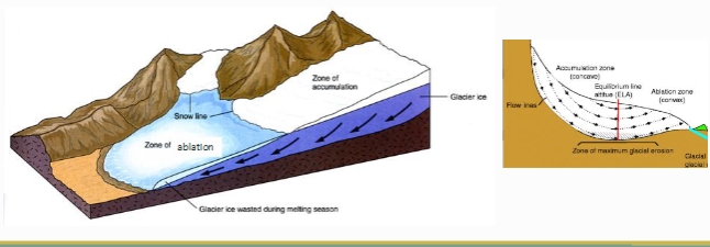
The equilibrium line altitude (ELA)
elevation where snow accumulation = snow melt
we reconstruct ELA in the past through moraines
unconstrained glaciers
ice sheets, ice caps and ice streams
Constrained glaciers
ice fields, valley glaciers, transection glaciers (interconnected valley glaciers), piedmont glaciers, cirque and niche glaciers
a glacier ____ when a huge mass of ice breaks off at the front of the glacier
calves
_____ due to their relatively fast flow and an extensional (stretching) flow at their lower end
crevasses
near-vertical __ ____ where calving happens
ice cliff
Abrasion
Scraping of rocks on the glacier bed
Quarrying
Plucking blocks from the glacier bed
Subglacial channel
Rivers under glaciers
Glaciers tend to
widen valley bases & oversteepen their sides → u-shaped valley
Cold-based glaciers on bedrock
very slow movement
Warm-based glaciers on bedrock
relatively slow movement
Warm-based glaciers on sediment
lubrication from melting ice makes it move faster
Lateral moraines
forms on the end of flowing ice
Terminal moraines
mark the farthest extent of the glacier
short wavelength energy
can pass through human bodies and Earth
hotter objects radiate energy at this wavelength
Long-wavelength energy
can be sensed as heart (like thermal infrared) or used to bounce off solid objects for locating (like radar)
Isolation
Earth’s axial tilt is why the tropics are where they are
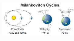
Milankovitch Cycles
Earth’s position relative to the sun varies on long timescales
In the past 2 million years, the pattern of continental ice sheet growth and decay has gone from a 41,000 year cycle to a 100,000 year cycle
Albedo
proportion of shortwave radiant energy scattered upward by a surface
Atmospheric CO2 is a product of
global wind patterns, patterns in ecosystem productivity, and anthropogenic sources (agriculture and fossil fuel burning)
Temperature inversion
usually air temp decreases w/ elevation, but in an inversion, it increases
ex: On clear, calm nights, the ground radiates energy back out
to space and the ground cools, cooling the air above it and
trapping the cold near the ground
Community
formed by interactions among populations of living organisms at a particular time
Habitat
type of enviornment in which an organism lives
Niche
function of an organism w/in a community
Components of the ecosystem
Abiotic (nonliving) and biotic (living)
Proxies
something that can be used to represent the value of something in a calculation
preserved in archives like sediments & ice cores
Biological proxies
plants and animals that tolerate specific climate conditions
Physical proxies
textural or sedimentological indicators of climate condition
Chemical proxies
the presence, quantity or composition of chemicals that are controlled by climate-dependent reactions
Producers
organisms capable of using CO2 as sole source of carbon (C)
Net photosynthesis
photosynthetic gain – respiration loss
Net primary productivity
net photosynthesis for whole plant community
2 types of Nutrient cycling
Gaseous (partly in atmosphere) & sedimentary (in lithosphere)
Oxygen cycle
first time the atmosphere had free oxygen - The Great Oxygenation Event (The GOE)
Banded iron formation (BIFs)
economically important iron ores that record early ocean oxygenation
Nitrogen cycle
Nitrogen fixation: chemical process by which NO2 is converted to NO3 (ammonia)
Nitrogen needs to be fixed to be made into amino acids, protein and nay nitrogen-containing organic compound
Carbon cycle
silicate (granite) weathering → C sink (removes carbon from the atmosphere)
Carbonate rocks getting cooked in the lithosphere → C source to the atmosphere
Wind is determined by
Pressure Gradients
out of a high and into a low, thats the way the wind likes to blow”
El Nino
trade winds blow east to west
warm air (low pressure) in the west & cold air in the east (high pressure)
heat from pacific ocean center
each event is different, sometimes reverses and lasts for months
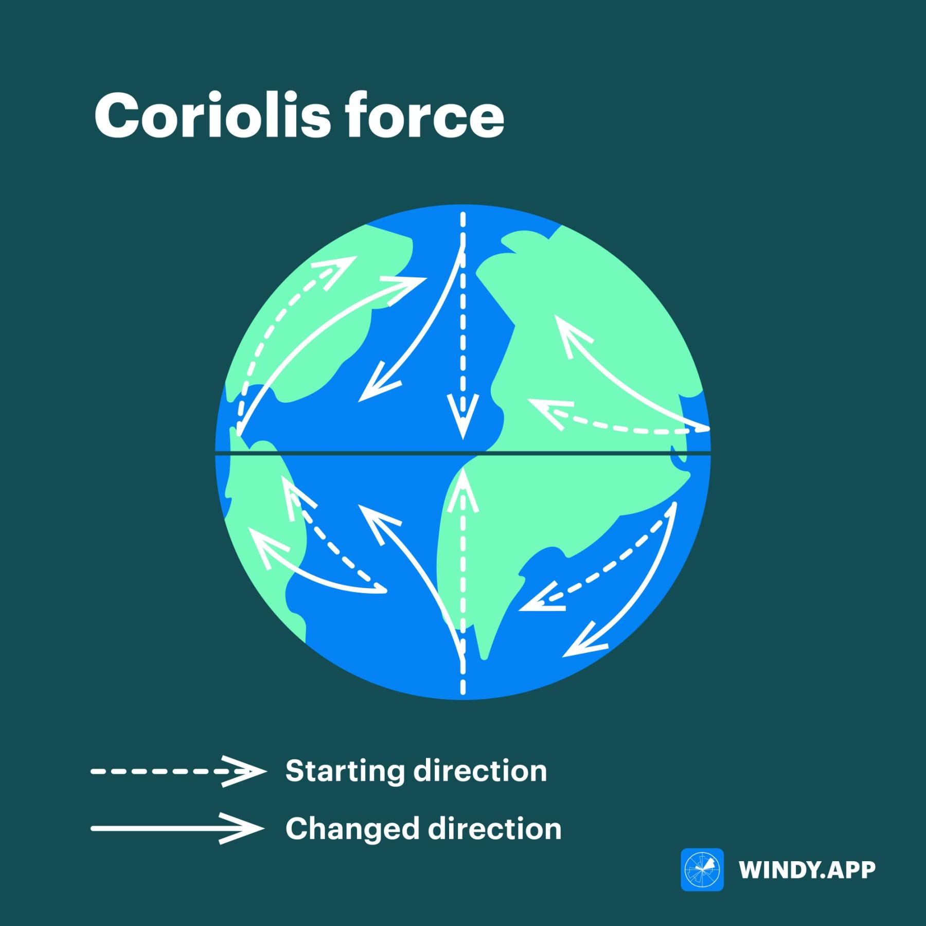
Coriolis Effect
horizontal wind motion
Earth’s rotation means that winds are deflected to the right in the northern hemisphere and to the left in the southern hemisphere
explains why hurricanes have crossed the equator
Hadley cells
Coriolis effect + differential heating of Earth’s surface = planet-wide wind circulation systems
Winds are named for the direction from which they come (so 30-60 degrees winds are called the Westerlies)
Europeans exploit this during triangular trade
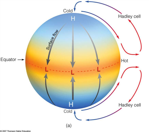
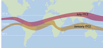
The Intertropical Convergence Zone (ITCZ)
Convergence of the trade winds, band of low pressure between the n and s hemisphere Hardley cells. area of low pressure causes heavy rain when it is over an area and drought when it moves elsewhere
position shifts w the seasons as sun hits north v south of the equator at diff times of the year
responsible for wet & dry seasons in the tropics
Humidity
Warm air can hold more moisture than dry air
air cooling → saturation-specific humidity decreases
more cooling → SSH = specific humidity
aka air is at max saturation (most possible water vapor)
more cooling → condensation
temp at which saturation occurs is the dew point temp (Temp at which condensation/dew forms)
Specific Humidity
the mass of water vapor in air over the mass of total air (the actual amount of water in a given volume of air
Saturation-specific humidity (aka maximum specific humidity)
the maximum quantity of moisture that a given volume of air can contain at any time
Dependent on air temperature
Relative humidity formula
𝑠𝑝𝑒𝑐𝑖𝑓𝑖𝑐 ℎ𝑢𝑚𝑖𝑑𝑖𝑡𝑦 × 100
𝑠𝑎𝑡𝑢𝑟𝑎𝑡𝑖𝑜𝑛 𝑠𝑝𝑒𝑐𝑖𝑓𝑖𝑐 ℎ𝑢𝑚𝑖𝑑𝑖𝑡𝑦
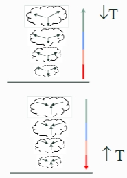
Stability
tendency of air parcel to stay in same place determined by difference in temperature of parcel & surrounding air
as air rises → hits lower air pressure → expands & cools
as air sinks → hits higher air pressure → contracts & heats
inc temp = dec density = air parcel rises
dec temp = inc density = air parcel sinks
Adiabatic rate
rate that air cools by expansion or heats by contraction
T change that occurs w/o heat exchange between surrounding environment & air parcel
Moist Adiabatic Rate (MAR)
rate for moist air (i.e., > 100% relative humidity)
avg MAR = 6C°/1000m
Dry Adiabatic Rate (DAR)
rate for dry air (i.e., < 100% relative humidity)
avg DAR = 10C°/1000m
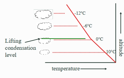
Lifting condensation level
altitude at which condensation begins (i.e., clouds form), switch from DAR to
MAR
When air parcels rise + condense
[Environmental] lapse rate =
rate that T dec with inc altitude
- still air (outside balloon)
Adiabatic = rate that T of
moving air parcel dec with inc
altitude
- moving air (inside balloon)
Unstable
Environmental lapse rate > adiabatic rates
(surrounding air cools more quickly with altitude than air parcel → air parcel will continue to rise)