GES 121 - Geological Basis of Physical Geography
1/10
There's no tags or description
Looks like no tags are added yet.
Name | Mastery | Learn | Test | Matching | Spaced |
|---|
No study sessions yet.
11 Terms
Two Roles of the Crust
Active: endogenic forces(from within)/geomorphic processes
create landforms and influence the distribution of living things, including humans, since these processes are natural hazards
- Tectonism
Passive: Resisting framework, exogenic forces (sun)
structure and composition of rock at earth’s surface influence weathering and erosion, movement of water, and physical/chemical properties of soil; spatial variation in these properties is significant and creates landscapes.
- Geomorphology
Tectonism (Active; Role of the Crust)
structural and structurally controlled landscapes, represents difference in patterns on the landscape
mountain building or folding
(other active stuff)
diastrophism: displacement and deformation of the crust
faulting: displacement of rock along a fracture in the crust (produces earthquakes)
folding: plastic deformation (bending) of rock
volcanism: the extrusion of magma, rock fragments, and gases through openings int he crust
plate tectonics: the global model of crustal deformation, displacement, and volcanism
Geomorphology (Passive; Role of the Crust)
the study of change of the shape of the earth and its present shape
Geomorphic Agents:
water - fluvial processes
wind - aeolian processes
oceanic water and wind - coastal processes
ice - glacial processes
Geomorphic Continuum
erosion (wear down by agents) → transport (usually by agents also) → deposition (perhaps change in base level (lake drained) or tectonic uplift (relief))
process repeats
Geomorphic Agents
water - fluvial processes
power of running water, geomorphic substance because of its density (1000kg/m3)
wind - aeolian processes
(1kg/m3) especially dry environments, particles moved by wind, wears down land
oceanic water and wind - coastal processes
lakes → wetland → squishy land → solid land
ice - glacial processes
formation, potholes by freezing in concrete, all of Canada covered by glacial ice in last period - capable of doing a lot of work at certain times in history, glacial lake basin → don’t find a lot of stones (good for farmers) because lots of stones at bottom of lake
ex. Qu’appelle Valley:
glacial drainage site!!! transported to oceans most likely, go through significant water places (Winnipeg, Hudson), at some point deposited
Tectonic Plates
mountains formed when Pangea came together, were huge! because of that force
Himalayas - India thrust into underbelly of Asia (newer, so bigger!)
now mountains worn down because of exogenic processes
western mountains older (Appalachian older than Rockies), so more time to be worn down
Different forces at different latitudes
Canadian/Brazilian Shields (very old rocks) core of the continents
can be overlayed with other materials when thrust up from sea floor or deposition
demolition derby
run into car, crush and move up, back up crash into something else, but like… driving across continents
Constructive and Destructive Plate Boundaries
destructive: crusts are consumed and forced into the depths
volcanoes
upon this boundary might be earthquakes (slip gradually or locked together then release suddenly)
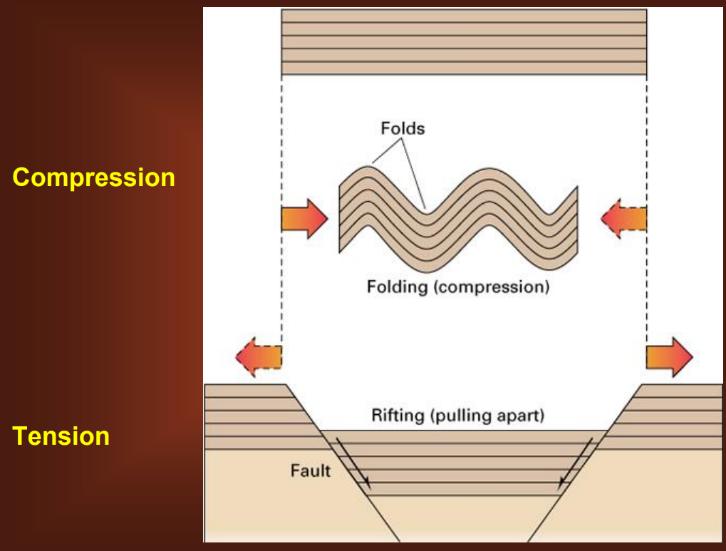
constructive: tensional force, create new crust
Compression: folds where crustal plates coming together, creating compressional force
Tension: rearranging in plates
both compression and tension creates changes in relief/elevation
will be a chance for things to move downslope (geomorphic processes)
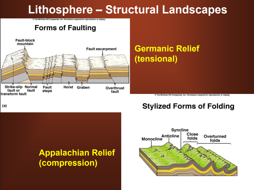
Structural Landscapes
still reflects original structure
results of tensional force - when crust pulls apart crust, rearranges itself → relief! fresh! new! just created!
process of creating relief
as soon as relief created, landscape is going to be attacked by geomorphic processes (exogenic forces at the surface)
volcanoes created because of these direct endogenic forces
These forces create relief:
Germanic Relief
tensional
Appalachian Relief
compression
Germanic and Appalachian Relief (Structural Landscapes)
these forces create relief
Germanic Relief: (tensional)
forms of faulting
lots of fault in south Germany
Eastern Africa rift zone/valley system - will probably eventually separate from the rest of the continent; continent rift zone
Appalachian Relief: (compression)
forms of folding
old mountain chains in particular
folding itself will create tensional forces at top of ridge (anticline), open up rock and more more erodible
Structurally Controlled Landsacpes
eroded structural landscapes, can kind of make out original features, but been extensively acted upon by erosion
based on faults: concentrated on anticlines, more worn down material; in synclines, harder to erode/more resistant by being pushed together
what used to be high point is now low point, vice versa
Plunging folds: crosscut across surfaces, folding/compression created landscape, but then exogenic forces gives zigzags and dips to the structure
monoclinal: a tilting strata, passive role of crust, resistant framework, one angle
Germanic Relief (Structurally Controlled Landscapes)
geomorphic processes eroding a germanic structural landscape (like an upthrust block)
fans at break of relief
river in confined space, then spread out as release of force
dumps sediment load at the break of slope, confined flow converted to unconfined flow
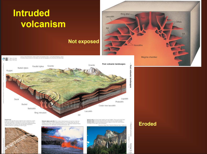
Intruded Volcanism (Structurally Controlled Landscapes)
when not exposed, magma intruded into existing rock strata (weak spots), over fairly large areas, so not very visible at surface
land slowly erodes, magma underneath either slowly cools into large crystals, or is thrust into air/water and fast cools, turning to granite which is not easily erodible
once exposed, becomes large area of resistant rock
helps us trace existing resources, deposits of minerals, and determine distributions