Dead reckoning & Flight Plan
 Call Kai
 Learn
Learn Practice Test
 Spaced Repetition
 Match
Match Flashcards
 Knowt Play
1/44

There's no tags or description
Looks like no tags are added yet.
Name | Mastery | Learn | Test | Matching | Spaced | Call with Kai | Chat |
|---|
No analytics yet
Send a link to your students to track their progress
45 Terms
What is “dead reckoning”?
An advanced version of pilotage
Using a chart/map to measure distance and direction between two points, then using the speed to calculate how long it will take to fly there.
What are some advantages of dead reckoning?
Doesn’t require assistance from ground stations (only needs a chart, plotter, and flight computer)
Can be done before or during the flight
What are some disadvantages of dead reckoning?
Based on approximations and estimated values (barely 100% accurate)
A time-consuming process to complete
Simply explain the steps of planning a flight using dead reckoning method
Draw a line from Point A to Point B
Use the chart to get the course and distance between the points
Determine the wind aloft
Correct the wind’s direction and speed
Find compass heading and ground speed
Figure out how long the flight will take
Find how much fuel you’ll use by calculating “fuel burn rate” (unit = Gallon per hour “GPH”)
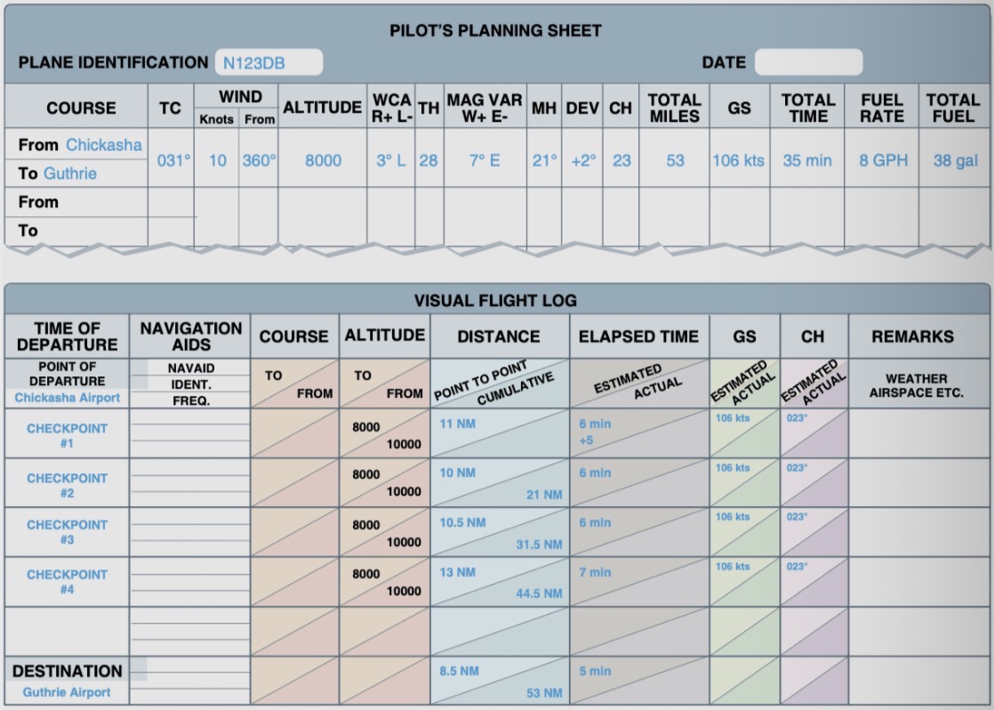
What do pilots flying dead reckoning have to do to prevent going off the course?
Constantly update their flight plan as they fly (flight planning log sheet)
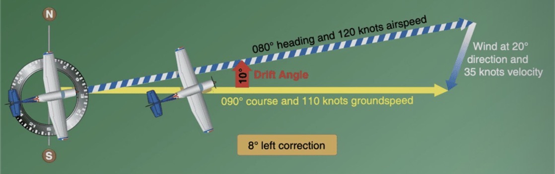
What are the 7 dead reckoning terms pilots need to know?
True course (TC)
Track (TR)
True Heading (TH)
True Airspeed (TAS)
Groundspeed (GS)
Drift Angle (DA)
Wind Correction Angle (WCA)
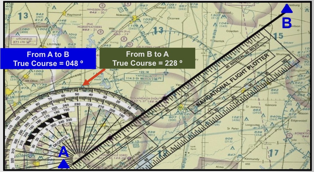
Explain “true course”
The course/direction measured on the chart by reference to a Meridian or True North (measured in degrees clockwise from TN)
Measured with a “navigation plotter”
Measured from true north before corrections for magnetic north are applied
Explain “track”
The actual path of the aircraft over the surface of the Earth
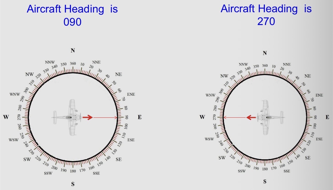
Explain “true heading”
The horizontal direction in which an aircraft is pointed
Angled measured clockwise from true north
True or false: “aircraft heading is a direction in which the aircraft nose points to”
True!
Explain “indicated airspeed”
The direct instrument reading obtained from Airspeed indicator (ASI)
The measured speed of an airplane as it moves through the air
Based on pressure readings collected by the pilot-static system (comparing 2 types of air pressure)
Explain “true airspeed”
TAS = Calibrated airspeed (CAS) corrected for altitude and temperature
Altitude increase → TAS increase (because higher altitude = lower air pressure, so to maintain the same pressure difference, aircraft must fly at high speed)
Used for flight planning and when filing a flight plan
Explain “ground speed”
The actual speed of the airplane over the ground
GS = TAS adjusted for wind
Has a major impact on the time it takes to get to a destination
Increases with the tailwind
Decreases with the headwind
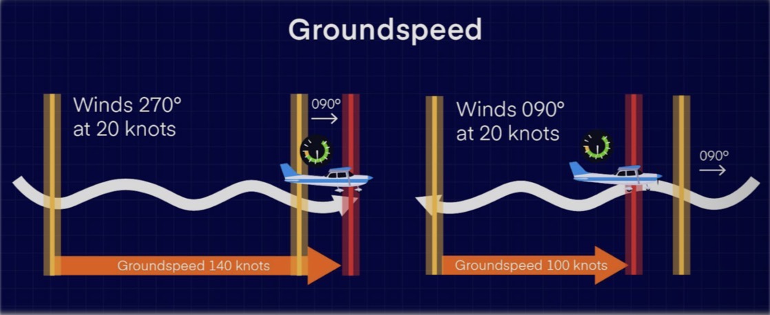
True or false: “wind direction is where it blows/comes from”
True!
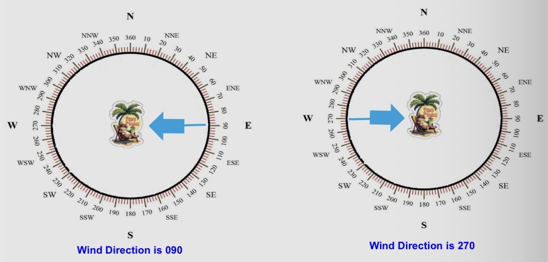
Explain the relationship between aircraft heading and wind direction
Opposite direction, same degrees = headwind
Same direction, opposite degrees = tailwind
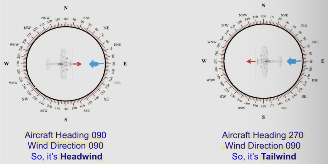
How to calculate ground speed? What are the formulas?
Headwind: GS = TAS - Wind Speed
Tailwind: GS = TAS + Wind Speed
**Check exercise on pg 30-31!
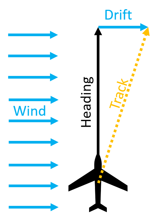
Explain “drift angle”
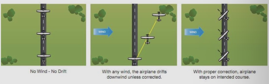
The lateral displacement of the aircraft caused by the wind
The angle between track and heading
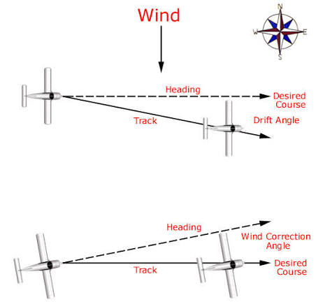
Explain “wind correction angle”
“Drift correction angle”
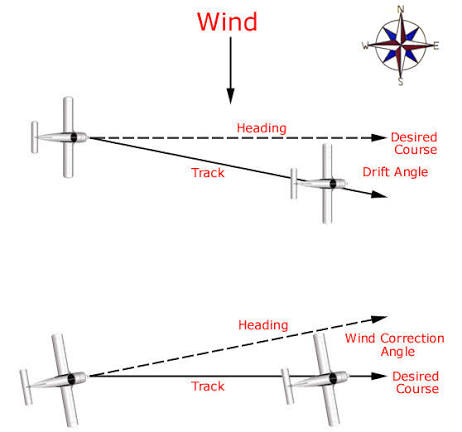
The angle between the heading of an airplane and the desired course
The adjustment that apply to a heading to remain on course
The correction angle applied to the aircraft’s course by pointing its nose towards the wind in such a way that it counteracts the effect of wind
Ensure that our aircraft follows its desired course
What is a “flight plan”?
A document which provides specified information to air traffic service units relative to an intended flight or portion of an aircraft
What is a “navigation flight plan”?
A document prepared in accordance with the instructions contained in the Operations Manual
Used in flight by the pilot to assist in navigation and safe operation of the aircraft
What are the key purposes of navigation flight plan?
Safety: Provide a way to alert search and rescue if a flight has missed its estimated time of arrival (ETA)
Air traffic control: Allow ATC to track an aircraft under IFR
Coordination: Facilitate coordination between different flights and ATC
Route planning: Outline the planned path, altitude, and timing of a flight
What kinds of information are contained in a flight plan? List as much as you can
Aircraft identification
Flight rules & type of flight
Number and type(s) of aircraft
Equipment
Departure Aerodrome
Estimated off-block time
Cruising speed
Cruising level
Route to be followed
Destination Aerodrome and total estimated time
Alternate aerodrome
Fuel endurance
Total number of persons on board
Emergency and survival equipment
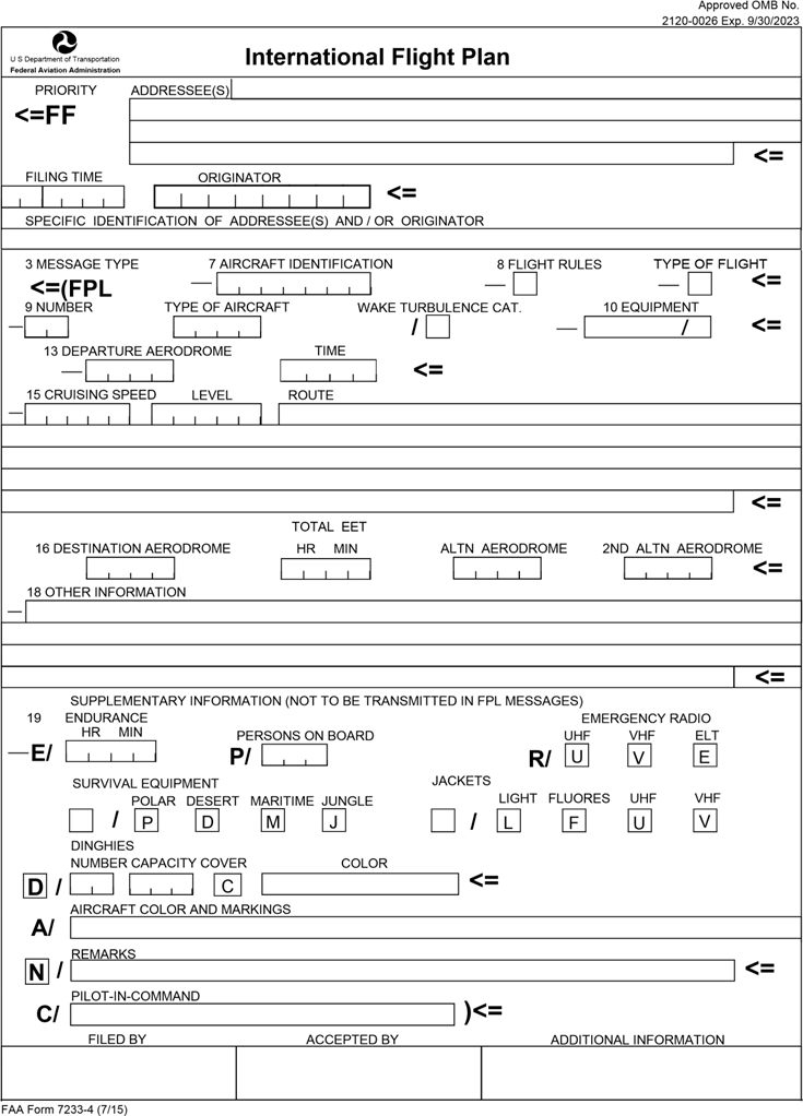
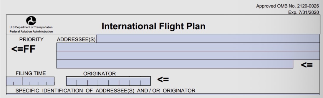
True or false: “addressee (s), filing time, and originator sections are filled by pilots”
False! (They are completed by ATCs!)

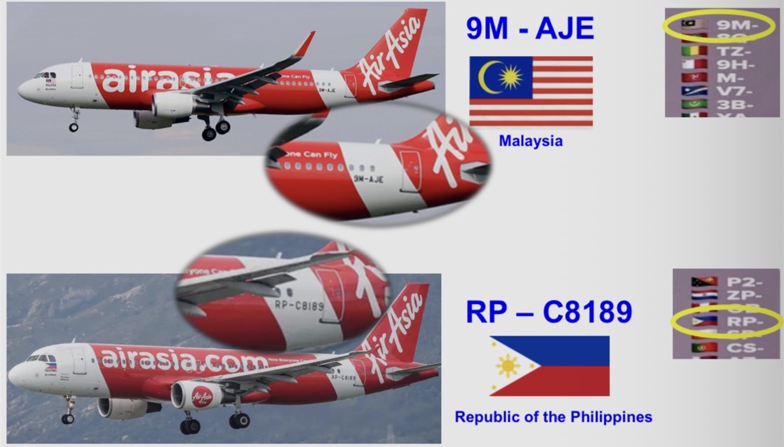
What details should you fill in “aircraft identification” section? Write down some examples
Aircraft registration → HS-TQA
Located on the side of aircraft tail
Operating agency followed by flight number → KLM511
Tactical call sign → RTAF121
***Must not exceed 7 characters
What details should you fill in “flight rules” section? Write down some examples
I = total time, IFR
V = total time, VFR
Y = IFR → VFR
Z = VFR → IFR

What details should you fill in “type of flight” section? Write down some examples
S = Schedule flight
N = Non-scheduled flight
G = General aviation
M = Military
X = Other than the preceding categories

What details should you fill in “number (of aircraft)” section? Write down some examples
If more than 1 aircraft in the flight → insert the number (up to 99)
If ONLY 1 aircraft → DO NOT insert anything

What details should you fill in “type of aircraft” section? Write down some examples
Insert appropriate designator as specified by ICAO
No designator/comprising of >1 types = “ZZZZ”
Specify in Item 18 (number and type of aircraft)

What details should you fill in “wake turbulence category” section? Write down some examples
H = Heavy (max cert. take-off mass 136,000kg or more)
M = Medium (max cert. take-off >7,000 to <136,000kg)
L = Light (max cert. take-off <7,000)

What details should you fill in “equipment” section? Write down some examples
***Equipment consists of: radio communication, navigation, approach aid equipment (e.g. VHF, RTF, VOR, ILS)
N = no COM/NAV/approach aid or “unserviceable”
S = has standard COM/NAV/approach aid or “serviceable”
D = DME
F = ADF
I = Inertial navigation
L = ILS
O = VOR

What details should you fill in “departure aerodrome” section? Write down some examples
Insert the ICAO 4 letters location identifier of the departure aerodrome
If no location = insert “ZZZZ” (then specified in Item 18)

What details should you fill in “time (of departure)” section? Write down some examples
Insert estimated departure time (UTC!)
If the flight plan was submitted before the departure on the same day = insert “HHMM”

What details should you fill in “cruising speed” section? Write down some examples
Insert true airspeed (TAS):
Kilometers per hour = K (followed by 4 figures) → K0445
Knots = N (followed by 4 figures) → N0290

What details should you fill in “level” section? Write down some examples
Insert the planned cruising level:
Flight level = F (followed by 3 figures) → F330 (33,000 ft.)
Altitude in hundreds of feet = A (followed by 3 figures) → A045 (4,500 ft.)

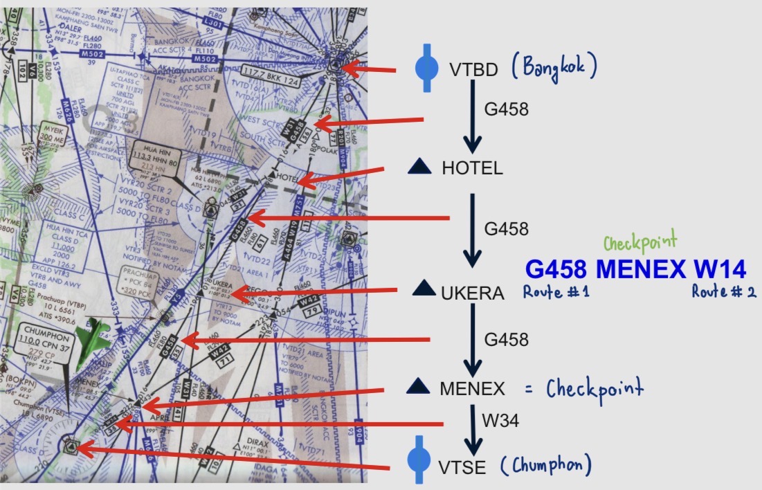
What details should you fill in “route” section? Write down some examples
Insert the designator of the first ATS route, or “DCT” (direct), followed by the point of joining the ATS route.
Insert a point at which either a change of speed/level, ATS route, flight rule is planned
Insert designator of the next ATS route

What details should you fill in “destination aerodrome” section? Write down some examples
Insert the ICAO 4 letters location identifier of the destination aerodrome
If no location = insert “ZZZZ” (then specified in Item 18)

What details should you fill in “total estimated elapses time” section? Write down some examples
Insert the total estimated elapsed time (EET)
Estimated time from take-off to arriving at the destination aerodrome

What details should you fill in “alternate aerodrome(s)” section? Write down some examples
Insert the ICAO 4 letter location identifier (**not more than 2 alternate aerodromes)
If no location = insert “ZZZZ” (then specified in Item 18)

What details should you fill in “other information” section? Write down some examples
No other information = insert “0”
Other necessary information

What details should you fill in “endurance” section? Write down some examples
A 4-figure group giving the fuel endurance in hours and minutes

What details should you fill in “persons on board” section? Write down some examples
Insert the total number of persons (passengers+crew)
If the total number of persons is not known at the time of filing = insert “TBN” (to be notified)

What details should you fill in “emergency” section? Write down some examples
In terms of radio:
Crossed out U = UHF (freq.243.0) is not available
Crossed out V = VHF (freq.121.5) is not available
Crossed out E = ELBA (emergency location beacon aircraft) is not available

What details should you fill in “survival equipment” section? Write down some examples
Crossed out ALL indicators = survival equipment is not carried
Crossed out P = polar survival equipment is not carried
Crossed out D = desert survival equipment is not carried
Crossed out M = maritime survival equipment is not carried
Crossed out J = jungle survival equipment is not carried