ap human geo unit 4 progress check
1/14
There's no tags or description
Looks like no tags are added yet.
Name | Mastery | Learn | Test | Matching | Spaced | Call with Kai |
|---|
No analytics yet
Send a link to your students to track their progress
15 Terms
Which of the following best explains why the countries shown in the table experienced increases in economic productivity?
A. Irredentism in former communist states and political divisions among ethnic and religious groups
B. Dissolving of the Warsaw Pact and economic alliances made with former republics of the Soviet Union
C. The rise of Russia as an emerging world economy and the economic impacts on its nearby trading partners
D. Independence following the end of the Cold War and admission to the North American Treaty Organization (NATO)
E. Self-determination following decline of communism and admission as member states to the European Union
Self-determination following decline of communism and admission as member states to the European Union
Which of the following best explains why the countries shown in the table experienced increases in economic productivity?

The area shown with the dark shading is best identified as
A. functional region
B. supranational organization
C. a regional free-trade zone
D. a stateless nation
E. a special economic zone
stateless nation
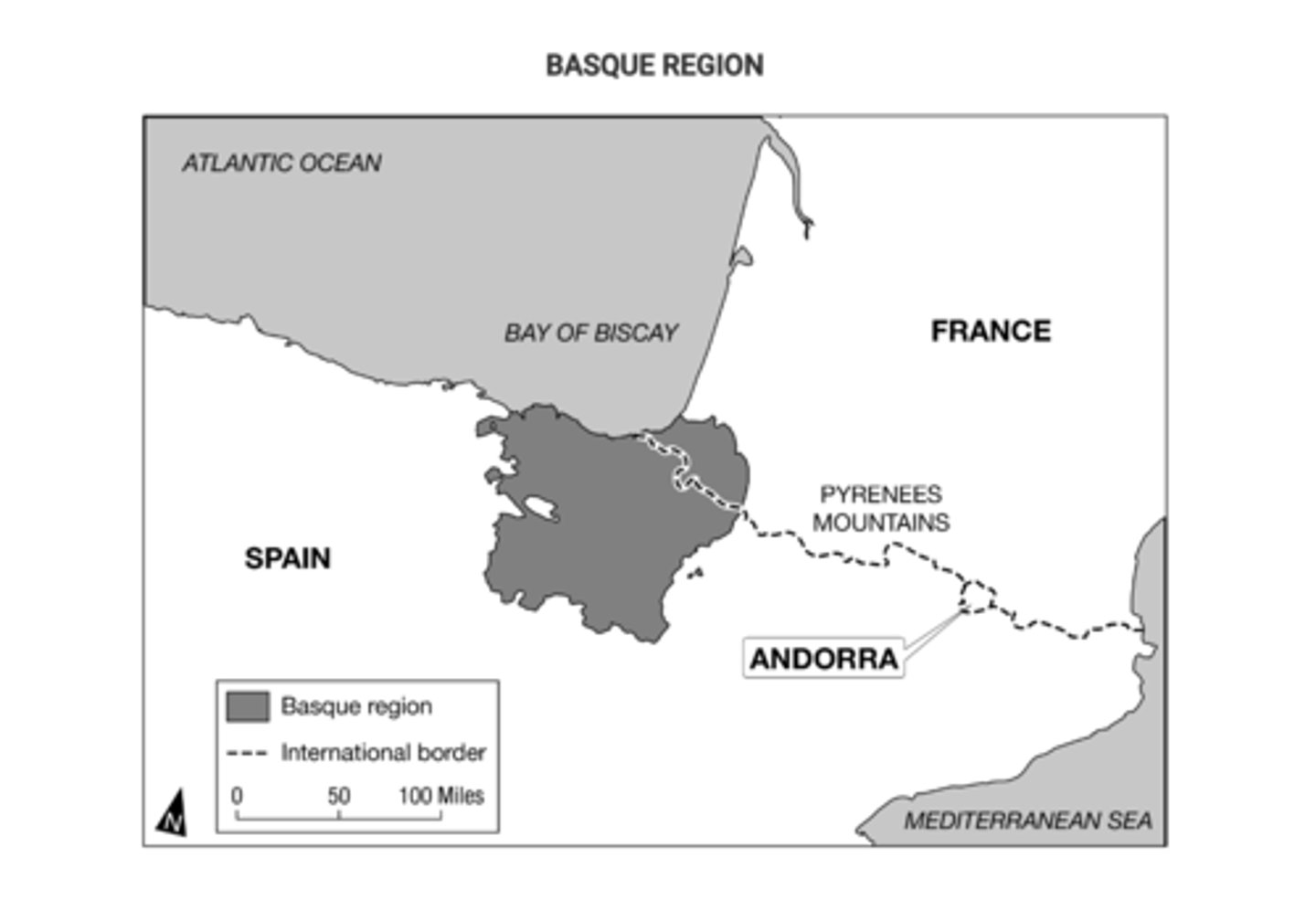
Local and regional autonomous governments and a separatist militia group have been established within the Basque region shown on the map. How do these local and regional governments compare with the national governments of Spain and France?
A. Local and regional governments establish the foundations for new federal states within each of the larger independent states.
B.Local and regional governments stabilize local communities, aligning the communities with the objectives of the larger independent states.
C. Local and regional governments create the potential for conflict and act as a centrifugal force within the larger independent states.
D. Local and regional governments strengthen the unitary systems of government within the larger independent states.
E. Local and regional governments create a stronger geopolitical region and act as a centripetal force within the larger independent states.
Local and regional governments create the potential for conflict and act as a centrifugal force within the larger independent states.

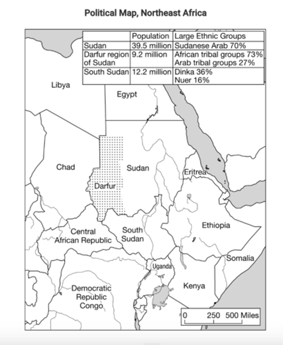
South Sudan gained its independence in 2011, reshaping the boundaries of Sudan. Which of the following best explains the implications of the shaded area shown on the map in Darfur?
A. Like South Sudan, Darfur has gained its independence and is now a sovereign nation-state.
B. Devolution is likely in Sudan as the country is a multinational state with no distinct majority group.
C. Darfur is a region of ethnic difference and political instability where devolution is likely.
D. Devolution is likely in South Sudan as it is landlocked country with no distinct majority group.
E. Sudan has a large population with a distinct majority group and further devolution is unlikely.
Darfur is a region of ethnic difference and political instability where devolution is likely.

The map shows the world's newest country, South Sudan, formerly part of Sudan, and the Islamic region of Darfur, which is seeking some level of political autonomy within Sudan. In comparison with the east-west divide between Darfur and the rest of Sudan, which of the following centrifugal forces led South Sudan to seek independence from Sudan?
A. South Sudan wanted a larger share of productive oil resources located in Ethiopia and Eritrea.
B. Sudan filed for bankruptcy in the International Court, whereas South Sudan grew wealthy from international trade.
C. Sudan and South Sudan are home to one homogeneous nation in terms of religion and ethnicity.
D. Sudan established a military presence in the region of South Sudan following a referendum vote, prompting a conflict.
E. Sudan and South Sudan's border is a transition zone between Africa's Islamic northern region and the Christian and animist regions of sub-Saha
Sudan and South Sudan's border is a transition zone between Africa's Islamic northern region and the Christian and animist regions of sub-Saharan Africa.
In 1993 Belgium divided much of its internal government into three semiautonomous regions. Based on the data shown in the map, which of the following best explains the political divisions within Belgium?
A. Each region is separated from the others by physical barriers that impede communication and trade among regions.
B. Regions are delineated based upon the percent of population that speaks French as a first or second language.
C. Divisions are based on language, providing ethnic groups some self-governance and preserving Belgium as a federal state.
D. The population is evenly divided between French speakers and Flemish speakers.
E. Divisions are based on ethnicity, recognizing the country's linguistic diversity and preserving Belgium as a multistate nation.
Divisions are based on language, providing ethnic groups some self-governance and preserving Belgium as a federal state.

Based on the map data, which of the following best explains a factor that has led to ethnic separatism in Belgium?
A. A multilingual society has emerged, with several languages being spoken by the overall population.
B. The populations of the three regions are not evenly balanced or equally distributed.
C. Many who speak French as their first language also speak Flemish, but few people who speak Flemish as their first language also speak French.
D. Many who speak Flemish as their first language also speak French, but few people who speak French as their first language also speak Flemish.
E. A multinational state has developed into a multicultural society where language and ethnicity are of little importance to personal identity.
Many who speak Flemish as their first language also speak French, but few people who speak French as their first language also speak Flemish.
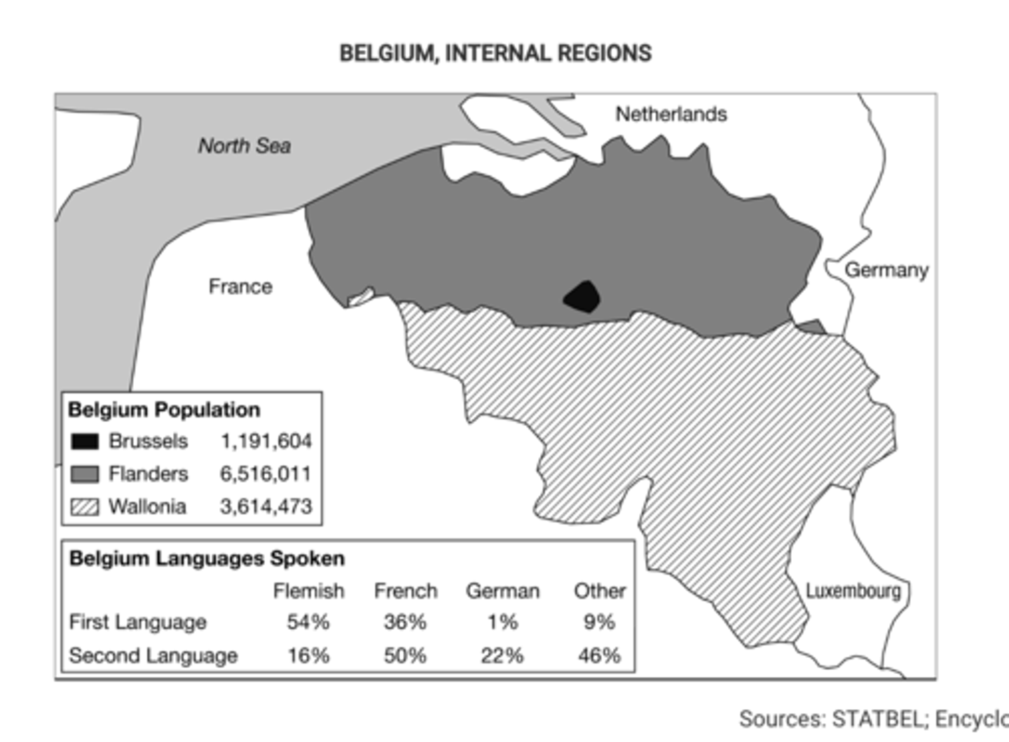
Some communities along the internal border between Flanders and Wallonia are required by Belgian federal law to have bilingual local governments, with road signs and government publications in Flemish and French. Some nearby communities refuse to permit a census of language users because they are concerned that the results will trigger federal requirements for a bilingual local government.
Which of the following geographic concepts best explains the efforts to preserve a single official language in such communities?
A. Choke points, because local communities are defining themselves as exclusively Flemish or French.
B. Protectionism, because these communities exclude services and international trade conducted in different languages.
C. Shatterbelts, because linguistic divisions are the result of different political-economic systems at the national and international scales.
D. Relict boundaries, because cultural divis

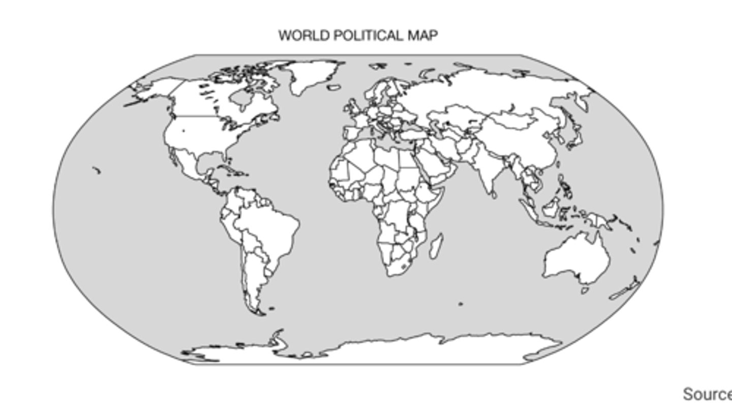
Which of the following identifies the primary building blocks of the world political map shown?
A. Nations
B. Multinational states
C. Independent states
D. Autonomous regions
E. Multistate nations
independent states
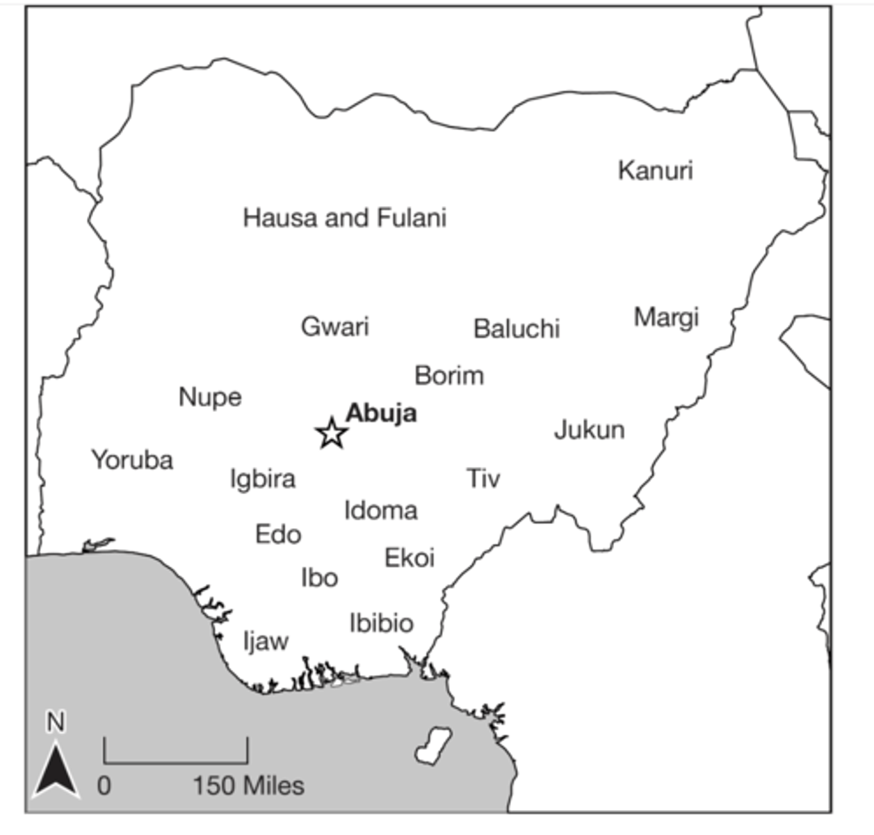
Based on the information shown in the map, Nigeria can be identified as a
A. multinational state
B. nation-state
C. colonial power
D. choke point
E. multistate nation
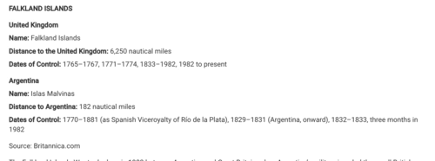
The Falkland Islands War took place in 1982 between Argentina and Great Britain, when Argentina's military invaded the small British overseas territory in the South Atlantic Ocean. British forces reclaimed the islands after a short war.Using the information shown, which of the following geographic principles explains the conflict in the Falkland Islands?
A. Irredentism and the desire to form a nation-state
B. Overlapping claims of sovereignty
C. A political independence movement against the ruling colonial power
D. The establishment of territorial seas
E. Ethnic and religious differences that led to the devolution of a state
Overlapping claims of sovereignty
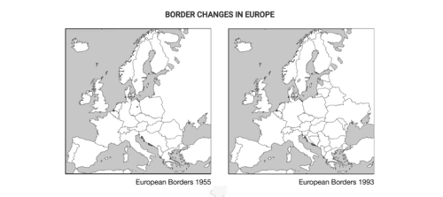
Despite the rise of supranationalism in Europe from 1955 to 1993, the number of independent political entities increased. Based on a comparison of the two maps shown, which of the following processes occurred in Europe during that time period?
A. Devolution of large states into smaller nation-states
B. Cultural globalization reducing ethnic differences
C. Annexation of smaller states into larger states
D. Redistricting the internal boundaries of federal states
E. Territorial expansion of imperial states
Devolution of large states into smaller nation states.
The geopolitical setting of which of the following countries can be explained by its membership in the Warsaw Pact during the Cold War and its location along the European shatterbelt?
A. France
B. Bulgaria
C. Italy
D. Switzerland
E. Belgium
Bulgaria
The map shows the Taiwan Strait. Which of the following best explains the global geopolitical significance of the Taiwan Strait?
A. The Taiwan Strait is a cultural boundary that separates populations of Chinese people who speak different languages.
B. The Taiwan Strait serves as a major international shipping route that serves large economies, such as South Korea, Japan, and the United States.
C. The Taiwan Strait is a militarily strategic chokepoint that China and Taiwan claim as territory.
D. The Taiwan Strait creates an obstacle to trade between Taiwan and China and hinders the region's economy.
E. The Taiwan Strait is a remnant of the colonial relationship between China, Taiwan, and European countries.
The Taiwan Strait is a militarily strategic chokepoint that China and Taiwan claim as territory.
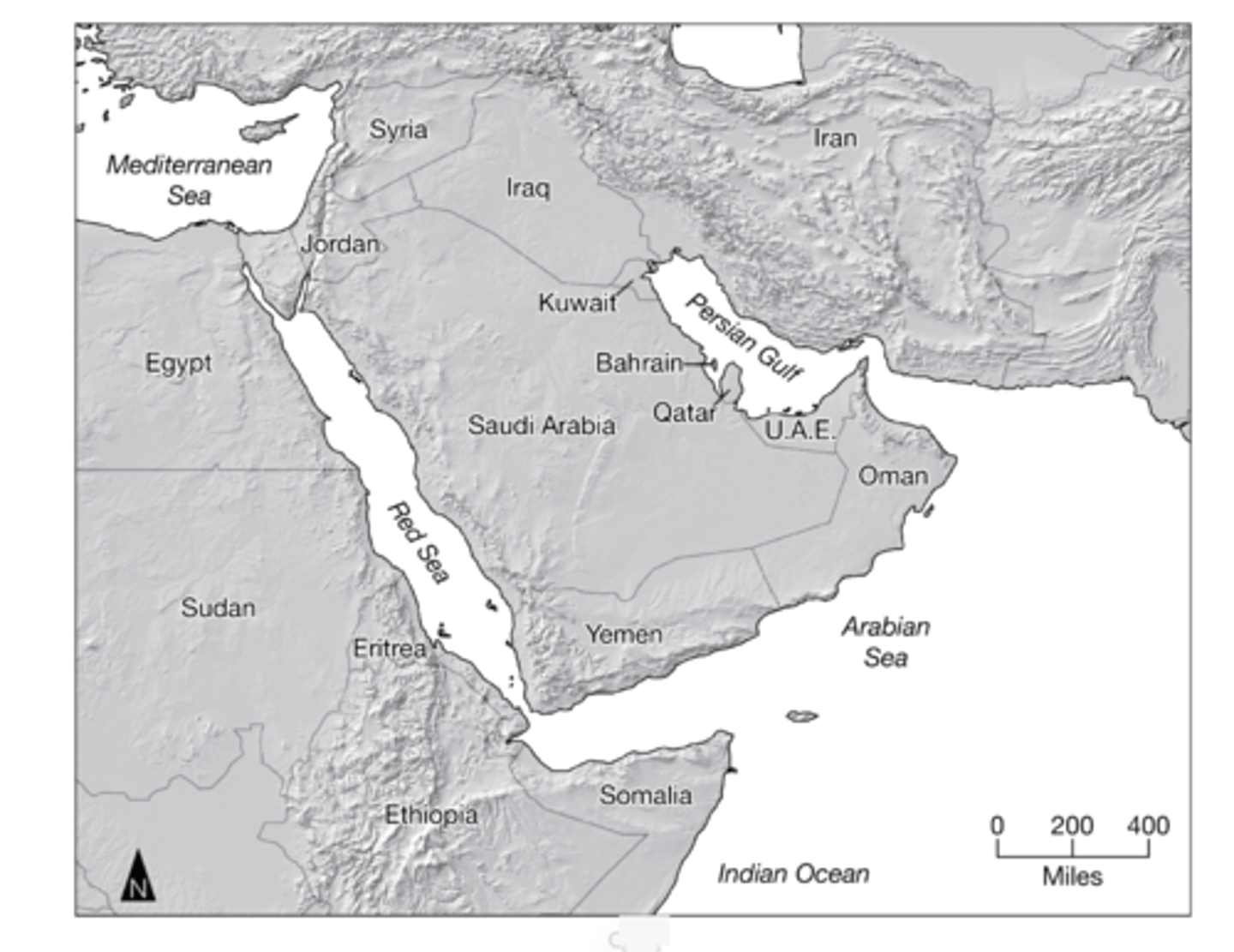
Which of the following statements is helpful in explaining why Iran and the United Arab Emirates (UAE) are able to assert some control over the export of oil from the Persian Gulf oil-production region?
A. Both Iran and the UAE have coastlines along the Arabian Sea and thus have the easiest access to global markets.
B. Their location along the choke point of the Strait of Hormuz allows them to influence ship movement into and out of the Persian Gulf.
C. Both Iran and the UAE border the Persian Gulf, a location of large oil deposits, and thus have the greatest offshore oil claims.
D. Their close proximity to the large Asian markets of Japan and China give them an economic advantage over other OPEC countries.
E. As the founding members of OPEC, they hold the largest influence over OPEC policies and decisions.
Their location along the choke point of the Strait of Hormuz allows them to influence ship movement into and out of the Persian Gulf.