aphg ch1
1/69
Earn XP
Description and Tags
i hate this chungus life
Name | Mastery | Learn | Test | Matching | Spaced | Call with Kai | Chat |
|---|
No analytics yet
Send a link to your students to track their progress
70 Terms
absolute distance
distance that can be measured with a standard unit of length (eg. mi, km)
absolute location
exact position of object/place measured within spatial coordinates of grid system (xyz)
accessibility
relative ease a destination can be reached from another place
aggregation
to come together into mass/sum/whole
azimuthal projection
map projection where plane is most developable surface

breaking point
outer edge of a city’s sphere of influence, used in law of retail gravity to desc. area of a city’s hinterlands that depend on city for retail supplies
cartograms
type of thematic map that transforms/distorts space so that the country/state with greatest value for some type of data is largest
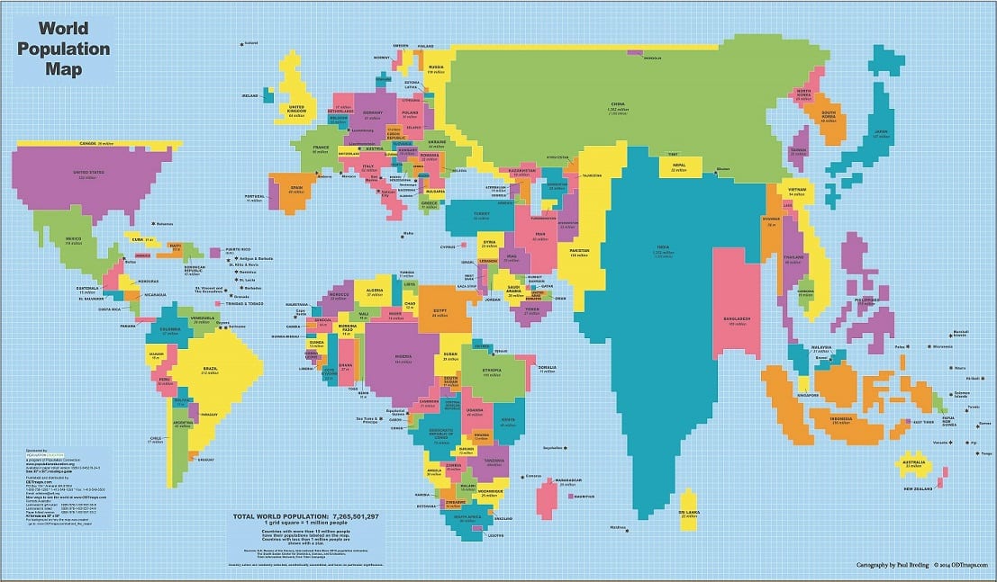
choropleth map
thematic map using tones/colours to represent spatial data as average values per unit area

cognitive map
image of a portion of earth’s surface that someone makes in their head. can include knowledge of actual locations/relationships between places along with personal perceptions/preferences of places
complementarity
actual/potential relationship between 2 places, usually referring to economic interactions
connectivity
degree of economic/social/cultural/political connection between 2 places
contagious diffusion
the spread of disease/innovation/cultural traits through direct contact with another person/place
cultural ecology
aka nature-society geography, study of interactions between societies and their natural environments
cultural landscape
human-modified natural landscape containing imprint of particular culture/society
distance decay effect
decrease in interaction between 2 things as distance between them increases
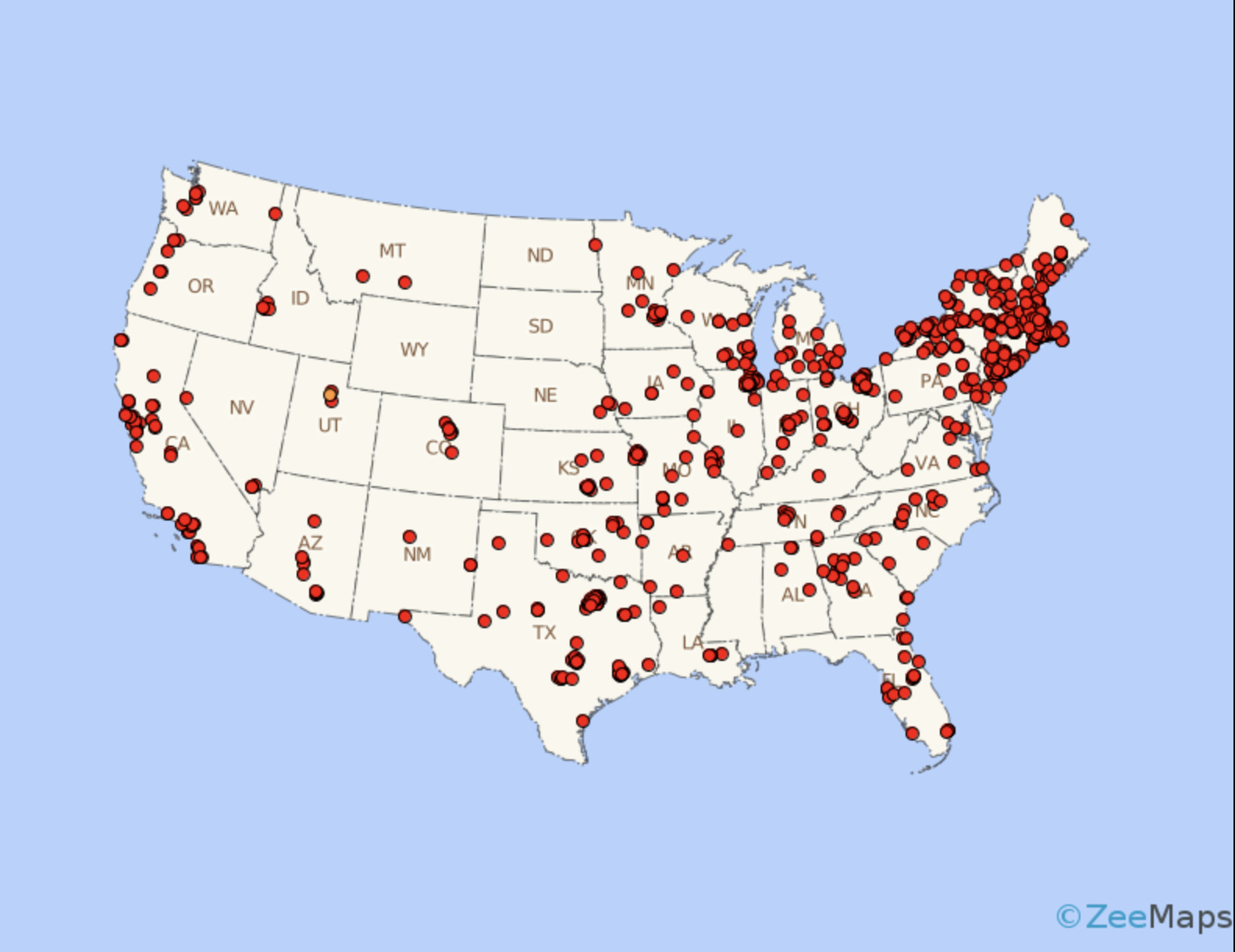
dot maps
thematic maps using points to show precise location of specific things (eg. crimes, car accidents, births)
expansion diffusion
spread of ideas/innovations/fashion/other phenomena. to surrounding areas through contact & exchange
formal region
definition of regions based on common themes (eg. language, climate, land use)
friction of distance
measure of how much absolute distance affects interaction between 2 places
fuller projection
type of map projection maintaining accurate size & shape of landmasses but rearranges direction
functional region
definition of regions based on common interaction/function (eg. boundary line around a newspaper’s circulation)
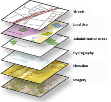
GIS
geographic information system
set of computer tools used to capture
geographic scale
scale that a geographer analyzes a phenomenon(eg. global, national, neighbourhood)
finer scale of analysis = richer level of detail in findings
GPS
global positioning system
set of satellites used to determine location anywhere on earth’s surface w/ a portable electronic device
gravity model
mathematical formula describing level of interactions between 2 places based on population size & distance from each other
hierarchial diffusion
type of diffusion in which smthn is transmitted between places bc of physical/cultural community between places
international date line
line of longitutde marking where each new day begins, centered on 180th meridian
intervening opportunity
1 places has demand for good/service w/ 2 places providing good/service of equal price/quality, supplier closer to buyer representing intervening opportunity. blocks other supplier from trading. used often bc transport decreases with proximity
isoline
map line connecting points of equal/very similar values
large scale
relatively small ration between map units & ground units, higher resolution & covering smaller regions
latitude
angular distance north/south of equator defined by lines of latitude/parallels
law of retail gravitation
people will be drawn to larger cities to conduct business bc larger cities have wider influence
location chart
map/chart/graph that gives specific statistical information about political unit/jurisdiction
longitude
angular distance east/west of prime meridian defined by lines of longitude/meridians
map scale
ratio between size of an area on a map and actual size
mercator projection
true conformal cylindrical map projection, maintains accurate direction. famous for distortion making areas new poles oversized
meridian
line of longitude running north-south. all equal in length, intersecting at poles
parallel
east-west line of latitude running parallel to equator & marking distance north/south of equator
w. d. pattison
claimed geography drew from 4 distinct traditions
earth-
perceptual region
highly individualized definition of regions based on perceived commonalities in culture * landscape
peters projection
equal-area projection centered on African in attempt to treat all earth’s regions equally

preference map
map displaying individual preferences for places
prime meridian
imaginary line passing through royal observatory in Greenwich, england, marking 0 degree line of longitutde
projection
system used to transfer locations from earth’s surface to flat map
proportional symbols map
thematic map in which size of a symbol indicates relative magnitude of statistical value for given geographic region

ptolemy
roman geographer-astronomer, author guide to geography including maps of a grid system of lat & long
qualitative data
data associated with humanistic approach to geography, collected through interviews/empirical observations/interpretation of texts/artwork/old maps/other archives
reference map
shows reference information for a particular place, useful for finding landmarks & navigation
quantitative data
data associated with mathematical models & statistical techniques to analyze spatial location & association
region
territory encompassing places that share similar physical/cultural attributes
relative distance
measure of distance including costs of overcoming friction of absolute distance separating 2 places. often describes amount of social/cultural/economic connectivity between 2 places
relative location
position of a place relative to places around it
relocation diffusion
diffusion of ideas/innovations/behaviours/etc. from one place to another through migration
remote sensing
observation & mathematical measurement of earth’s surface using aircraft & satellites. sensors include photos, thermal images, multi spectral scanners, radar images.
resolution
map’s smallest discernible unit (eg. item has to be 1km long to show on map)
robinson projection
attempts to balance all projection errors. minimizes errors in area, shape, distance, direction.

carl sauer
defined concept of cultural landscape as fundamental unit of geographical analysis. landscape results from interaction between humans & physical environment. argued no landscape escaped alteration by human activity
scale of analysis
geographic unit at which one investigates patterns/processes (province vs nation vs globe)
site
absolute location of a place described by local relief, landforms, other cultural/physical characteristics
situation
relative location of a place in relation to physical/cultural characteristics of surrounding area & connections/interdependencies within system; place’s spacial context
small scale
map scale ration, ratio of units on map to earth is small. depicting large areas
spatial diffusion
ways in which phenomena (eg. tech innovations, cultural trends, disease outbreaks) travel over space
spatial perspective
intellectual framework looking at particular locations of specific phenomenon, how & why phenomenon is where it is, how it is spatially related to other phenomena in other places
sustainability
concept of using earth’s resources so that they provide for current generation w/out diminishing ability to provide for future generations
thematic layers
individual maps of specific features overlaid on one another in a GIS to understand & analyze a special relationship
thematic map
type of map displaying 1 or more variables (eg. population/invcome level) within specific area
time-space convergence
idea that distance between places is shaking bc of technology & rapid communication/increased interaction
topographic maps
maps using isolines to represent constant elevations; isoline representing same elevation
transferability
cost involved in moving goods
visualization
use of sophisticated software to create dynamic computer maps, sometimes 3d or interactive