APHUG - All Vocab
1/419
Earn XP
Name | Mastery | Learn | Test | Matching | Spaced |
|---|
No study sessions yet.
420 Terms
Absolute distance
A distance that can be measured with a standard unit of length, such as a mile or kilometer.
Absolute location
The exact position of an object or place, measured within the spatial coordinates of a grid system.
Accessibility
The relative ease with which a destination may be reached from some other place.
Aggregation
To come together into a mass, sum, or whole.
Anthropogenic
Human-induced changes on the natural environment.
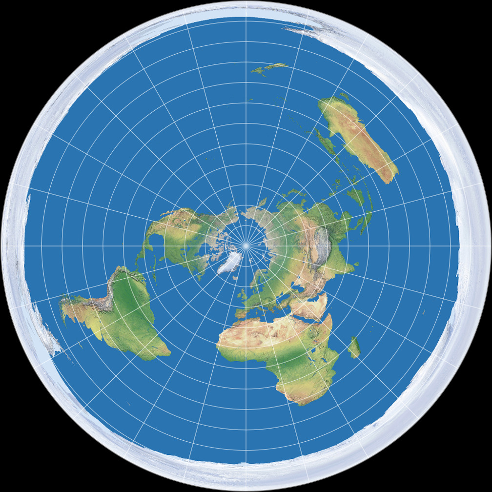
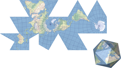
Azimuthal projection
A map projection in which the plane is the most developable surface. Has the North or South pole at the center of the map.
Breaking point
The outer edge of a city’s sphere of influence, used in the law of retail gravitation to describe the area of a city’s hinterlands that depend on that city for its retail supplies.
(It’s the furthest reach of a city’s social and economic influence).
Cartograms
A type of thematic map that transforms space such that the political unit with the greatest value for some type of data is represented by the largest relative area.
(Map where geographic size is altered to be directly proportional to a selected variable.)
Cartography
The theory and practice of making visual representations of Earth’s surface in the form of maps.
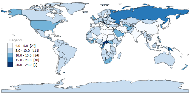
Choropleth map
A thematic map that uses tones or colors to represent spatial data as average values per unit area.
Cognitive map
An image of a portion of Earth’s surface that an individual creates in his or her mind. _____ _____can include knowledge of actual locations and relationships among locations as well as personal perceptions and preferences of particular places.
Complementarity
The actual or potential relationship between two places, usually referring to economic interactions.
Connectivity
The degree of economic, social, cultural, or political connection between two places.
Contagious diffusion
The spread of a disease, an innovation, or cultural traits through direct contact with another person or another place.
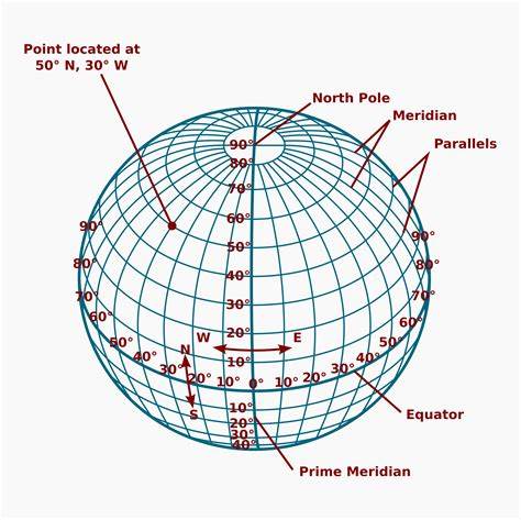
Coordinate system
A standard grid, composed of lines of latitude and longitude, used to determine the absolute location of any object, place, or feature on Earth’s surface.
Cultural ecology
Also called Nature-Society Geography & Nature-society, the study of the interactions between societies and the natural environments in which they live.
Cultural landscape
The human-modified natural landscape specifically containing the imprint of a particular culture or society.
Distance Decay Effect
The decrease in interaction between two phenomena, places, or people as the distance between them increases.
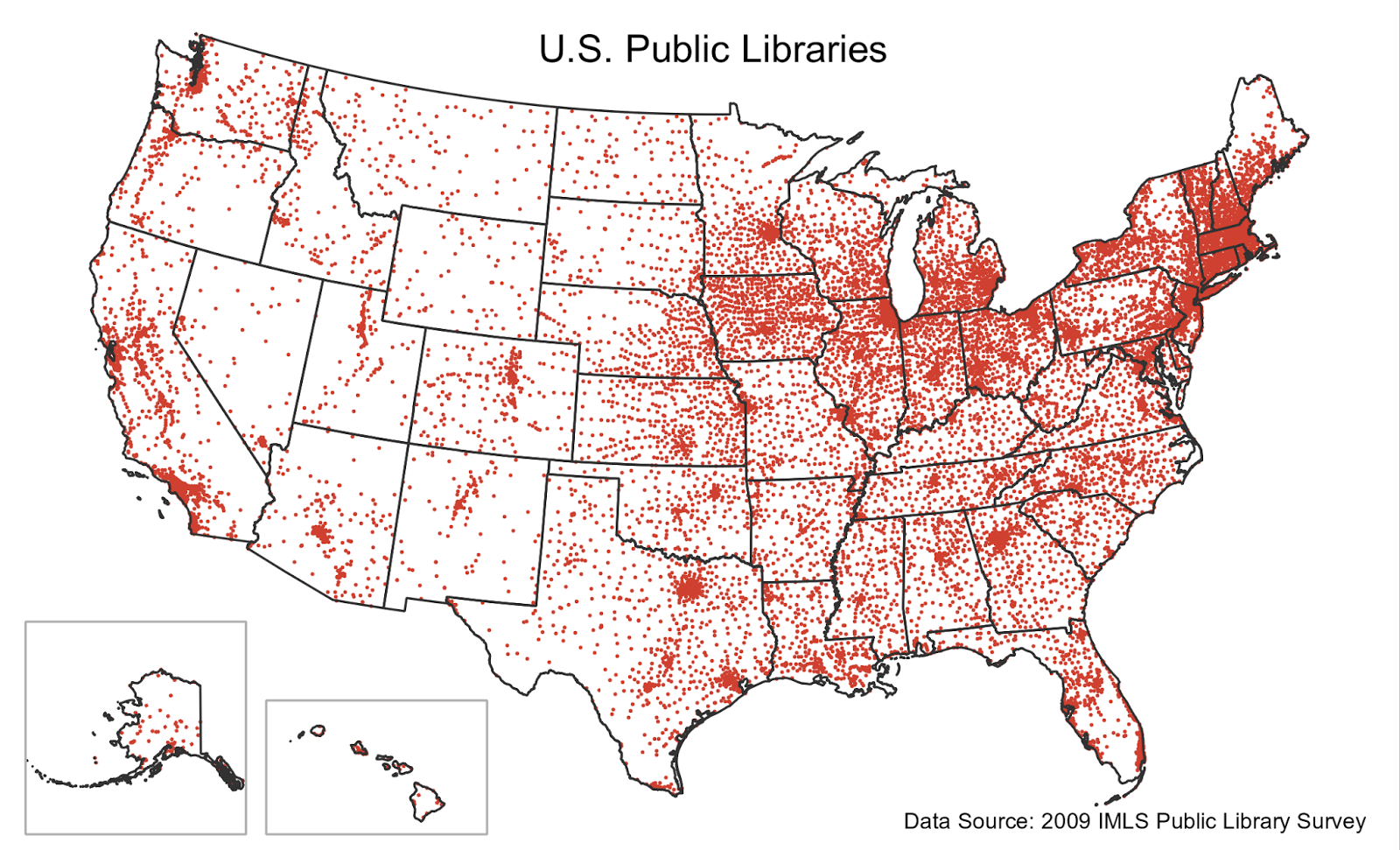
Dot maps
Thematic maps that use points to show the precise locations of specific observations or occurrences, such as crimes, car accidents, or births.
Earth system science
A systematic approach to physical geography that looks at the interaction between Earth’s physical systems and processes on a global scale.
Environmental geography
The intersection between human and physical geography, which explores the spatial impacts humans have on the physical environment and vice versa.
Eratosthenes
Inventor of the word “geography,” accepted that the Earth was round (despite most not during his time), calculated Earth’s circumference within 0.5% accuracy, divided Earth into 5 climatic regions, and made one of the first geography books.
Expansion diffusion
The spread of ideas, innovations, fashion, or other phenomena to surrounding areas through contact and exchange.
Fertile Crescent
Crescent-shaped region in the Middle East, believed to be the very first region where settled farming emerged as people started the process of clearance and modification of natural vegetation to grow newly domesticated plants as crops.
Place where hunters and gatherers first started to settle down and being farming.
Formal region
Definition of regions based on common themes such as similarities in language, climate, land use, etc.
Friction of distance
A measure of how much absolute distance affects the interaction between two places.
Fuller projection
A type of map projection that maintains the accurate size and shape of landmasses but completely rearranges direction such that the four cardinal directions— north, south, east, and west—no longer have any meaning.
Functional region
Definition of regions based on common interaction (or function), for example, a boundary line drawn around the circulation of a particular newspaper.
Geographic Information Systems (GIS)
A set of computer tools used to capture, store, transform, analyze, and display geographic data.
Geographic scale
The scale at which a geographer analyzes a particular phenomenon—for example, global, national, census tract, neighborhood, etc. Generally, the finer the scale of analysis, the richer the level of detail in the findings.
Geoid
The actual shape of Earth, which is rough and oblate, or slightly squashed. Earth’s diameter is longer around the equator than along the north-south meridians.
Global Positioning System (GPS)
A set of satellites used to help determine location anywhere on Earth’s surface with a portable electronic device.
Gravity Model
A mathematical formula that describes the level of interaction between two places, based on the size of their populations and their distance from each other.
Hierarchical diffusion
A type of diffusion in which something is transmitted between places because of a physical or cultural community between those places.
Human geography
The study of the spatial variation in the patterns and processes related to human activity.
Idiographic
Used to describe or refer to a feature that is unique to a particular geographic region.
International Date Line
The line of longitude that marks where each new day begins, centered on the 180th meridian.
Intervening opportunity
If one place has a demand for some good or service and two places have a supply of equal price and quality, the supplier closer to the buyer will represent an intervening opportunity, thereby blocking the other places with supply from getting business. Intervening opportunities are frequently used because transportation costs usually decrease with proximity.
Isoline
A map line that connects points of equal or very similar values.
Large scale
A relatively small ratio between map units and ground units. Large-scale maps usually have higher resolution and cover much smaller regions than small-scale maps.
Latitude
The angular distance north or south of the equator, defined by lines of ____ or parallels.
Law of Retail Gravitation
A law stating that people will be drawn to larger cities to conduct their business since larger cities have a wider influence on the surrounding hinterlands.
Location charts
On a map, a chart or graph that gives specific statistical information about a particular political unit or jurisdiction.
Longitude
The angular distance east or west of the Prime Meridian, defined by lines of _____, or meridians
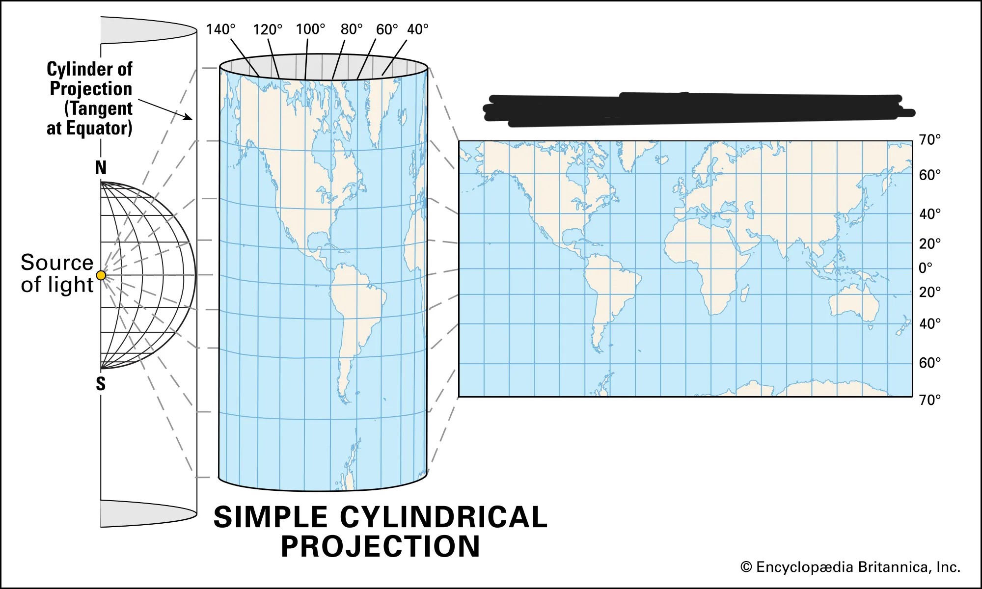
Map projection
A mathematical method that involves transferring Earth’s sphere onto a flat surface. This term can also be used to describe the type of map that results from the process of projecting. All _____ _____ have distortions in area, direction, distance, or shape.
Map scale
The ratio between the size of an area on a map and the actual size of that same area on Earth’s surface.
George Perkins Marsh
Inventor, diplomat, politician, and scholar. His classic work, Man and Nature, or Physical Geography as Modified by Human Action, provided the first description of the extent to which natural systems had been impacted by human actions.
Mercator projection
A true conformal cylindrical map projection, the _______ projection is particularly useful for navigation since it maintains accurate direction. _______ projections are famous for their distortion in area that makes landmasses at the poles appear oversized.
Meridian
A line of longitude that runs north-south. All lines of longitude are equal in length and intersect at the poles.
Natural landscape
The physical landscape or environment that has not been affected by human activities.
Nature-society
(AKA nature-society geography & Cultural ecology) The study of interactions between societies and the natural environments in which they live.
Nomothetic
Concepts or rules that can be applied universally across a multitude of regions.
Parallel
An east-west line of latitude that runs parallel to the equator and that marks distance north or south of the equator.
W. D. Pattison
Geographer who claimed that geography drew from four distinct traditions.
[4 distinct traditions are: The earth-science tradition (physical geography), the culture-environment tradition (environmental geography), the locational tradition (analysis of spatial data through cartography), and the area-analysis tradition (regional geography).]
Perceptual region
Highly individualized definition of regions based on perceived commonalities in culture and landscape.
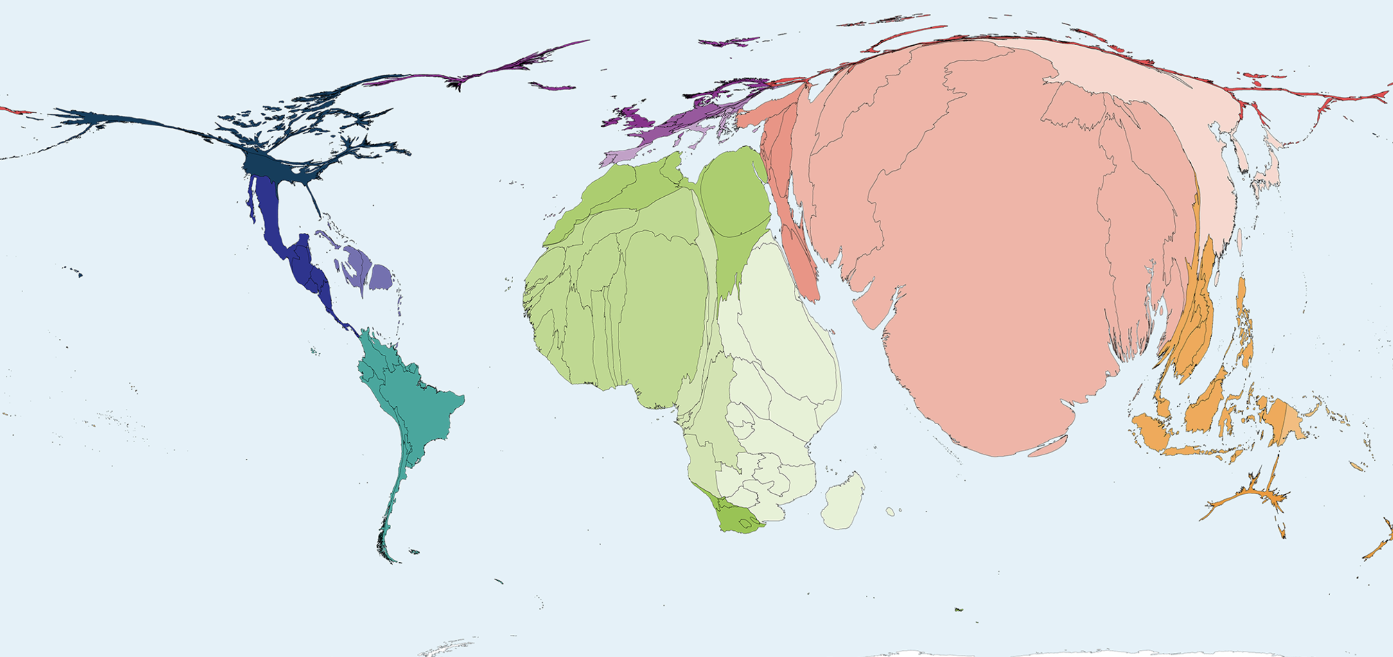
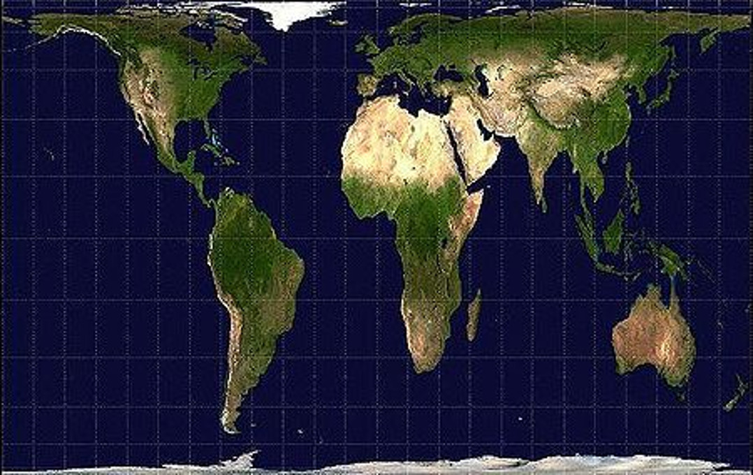
Peters Projection
An equal-area projection purposely centered on Africa in an attempt to treat all regions of Earth equally.
Physical geography
The realm of geography that studies the structures, processes, distributions, and changes through time of the natural phenomena of Earth’s surface.
Preference map
A map that displays individual preferences for certain places.
Prime meridian
An imaginary line passing through the Royal Observatory in Greenwich, England, that marks the 0° line of longitude.
Projection
The system used to transfer locations from Earth’s surface to a flat map.
Proportional symbols map
A thematic map in which the size of a chosen symbol—such as a circle or triangle—indicates the relative magnitude of some statistical value for a given geographic region.
Ptolemy
Roman geographer-astronomer, author of Guide to Geography, which included maps containing a grid system of latitude and longitude.
Qualitative data
Data associated with a more humanistic approach to geography, often collected through interviews, empirical observations, or the interpretation of texts, artwork, old maps, and other archives.
Quantitative data
Data associated with mathematical models and statistical techniques used to analyze spatial location and association.
Quantitative Revolution
A period of major shifts in human geography with widespread adoption of mathematical models and statistical techniques, as there was desire for rigorous and systematic methodology for the system of geography.
Reference map
A map type that shows reference information for a particular place, making it useful for finding landmarks and for navigation.
Region
A territory that encompasses many places that share similar physical and/or cultural attributes.
Regional geography
The study of geographic regions.
Relative distance
A measure of distance that includes the costs of overcoming the friction of absolute distance separating two places. _____ _____ often describes the amount of social, cultural, or economic connectivity between two places.
Relative location
The position of a place relative to the places around it. (aka Situation)
Relocation diffusion
The diffusion of ideas, innovations, behaviors, and so on from one place to another through migration.
Remote sensing
The observation and mathematical measurement of Earth’s surface using aircraft and satellites. The sensors include photographic images, thermal images, multispectral scanners, and radar images.
Resolution
A map’s smallest discernible unit. If, for example, an object has to be one kilometer long in order to show up on a map, that map’s ______ is one kilometer.
Robinson Projection
A projection that attempts to balance several possible projection errors. It does not maintain area, shape, distance, or direction completely accurately, but it minimizes errors in each.
Carl Sauer
Geographer from the University of California at Berkeley who defined the concept of cultural landscape as the fundamental unit of geographical analysis. This landscape results from the interaction between humans and the physical environment. He argued that virtually no landscape has escaped alteration by human activities.
Sense of Place
Feelings evoked by people as a result of certain experiences and memories associated with a particular place.
Site
The absolute location of a place, described by local relief, landforms, and other cultural or physical characteristics.
Situation
The relative location of a place in relation to the physical and cultural characteristics of the surrounding area and the connections and interdependencies within that system; a place’s spatial context.
Small scale
A map scale ratio in which the ratio of units on the map to units on Earth is quite small. ____ ____maps usually depict large areas.
Spatial diffusion
The ways in which phenomena, such as technological innovations, cultural trends, or even outbreaks of disease, travel over space.
Spatial perspective
An intellectual framework that looks at the particular locations of a specific phenomenon, how and why that phenomenon is where it is, and, finally, how it is spatially related to phenomena in other places.
Sustainability
The concept of using Earth’s resources in such a way that they provide for people’s needs in the present without diminishing Earth’s ability to provide for future generations.
Thematic layers
Individual maps of specific features that are overlaid on one another in a Geographical Information System to understand and analyze a spatial relationship.
Thematic map
A type of map that displays one or more variables—such as population or income level—within a specific area.
Time-Space Convergence
The idea that distance between some places is actually shrinking as technology enables more rapid communication and increased interaction among those places.
Topographic maps
Maps that use isolines to represent constant elevations. If you took a _____ _____ out into the field and walked exactly along the path of an isoline on your map, you would always stay at the same elevation.
Topological space
The amount of connectivity between places, regardless of the absolute distance separating them.
Transferability
The costs involved in moving goods from one place to another.
Visualization
Use of sophisticated software to create dynamic computer maps, some of which are three dimensional or interactive.
Age-Sex distribution
A model used in population geography that describes the ages and numbers of males and females within a given population; also called a population pyramid.
Agricultural density
The number of farmers per unit area of farmland.
Arithmetic density
The number of people living in a given unit area.
Baby Boom
A cohort of individuals born in the United States between 1946 and 1964, which was just after World War II in a time of relative peace and prosperity. These conditions allowed for better education and job opportunities, encouraging high rates of both marriage and fertility.
Baby Bust
Period during the 1960s and 1970s when fertility rates in the United States dropped as large numbers of women from the baby boom generation sought higher levels of education and more competitive jobs, causing them to marry later in life. As such, the fertility rate dropped considerably, in contrast to the baby boom, in which fertility rates were quite high.
Carrying capacity
The largest number of people that the environment of a particular area can sustainably support.
Census tract
An area delineated by the US Bureau of the Census for which statistics are published; in urban areas, ____ ____ correspond roughly to neighborhoods.
Chain migration
The migration event in which individuals follow the migratory path of preceding friends or family members to an existing community.
Child mortality rate
Number of deaths per thousand children within the first five years of life.
Cohort
A population group unified by a specific common characteristic, such as age, and subsequently treated as a statistical unit.
Cotton Belt
The term by which the American South used to be known, as cotton historically dominated the agricultural economy of the region. The same area is now known as the New South or Sun Belt because people have migrated here from older cities in the industrial north for a better climate and new job opportunities.