depositional land forms (8.2) - not done see learner guide
1/44
There's no tags or description
Looks like no tags are added yet.
Name | Mastery | Learn | Test | Matching | Spaced |
|---|
No study sessions yet.
45 Terms
what is a bar/barrier beach?
they are a linear ridge of sand/shingle extending across a bay and are connected to land on both sides (two proximal ends).
It traps a body of seawater behind it, forming a lagoon.
another definition of a barrier beach is a ridge of material emerging just offshore to form a chain of beaches parallel to the coast (barrier islands). e.g. the Friesian islands off the North Sea coast of the Netherlands and Germany
how are bars/barrier beaches formed?
a drift aligned coastline, longshore drift extends a spit across the entire width of the bay (or 2 spits merge towards each other caused by opposite prevailing winds)
Rising sea levels cause constructive waves to drive a ridge of sediment (offshore bar) onshore to coastlines with a gently sloping shallow sea bed and are swash aligned (barrier beach).
e.g. Start Bay in in Devon, trapping Slapton Ley Lagoon behind it
what is a spit?
long narrow ridge o sand and shingle which project from the coastline into the sea
two types of spit
simple spits which just extend as a basic straight (ish) line
compound spits which are hooked ore recurved at the distal end
what are spits associated with?
drift aligned
change in direction of coastline
large amount of sediment
river (stops it from becoming a bar)
how are spits formed?
formation begins due to a change in the direction of the coastline, where a low energy one is found.
this can be at the mouth of the estuary because the flow of water into the sea at an estuary is stronger than the drift forcing the sediment to be deposited.
main source of material building up a spit is from longshore drift and current, which brings material from further down the coast.
LSD will transport material at a faster rate than it can be removed, and gradually a ridge is built up, projecting outwards in the sea.
this continues to grow by the process of LSD and the continuous deposition of material.
water begins to stagnate, mud and marshland often begins to colonise behind the spit.
behind the spit where the wind is strong enough to lift sediment off the beach off the beach, dunes may form which adds stabilisation to the spit where pioneer plants such as marram grass anchor the sand.
a change in prevailing wind and wave direction often causes the end of spits to become hooked (recurved lateral).
overtime several recurved ends many form as waves return to their dominant direction.
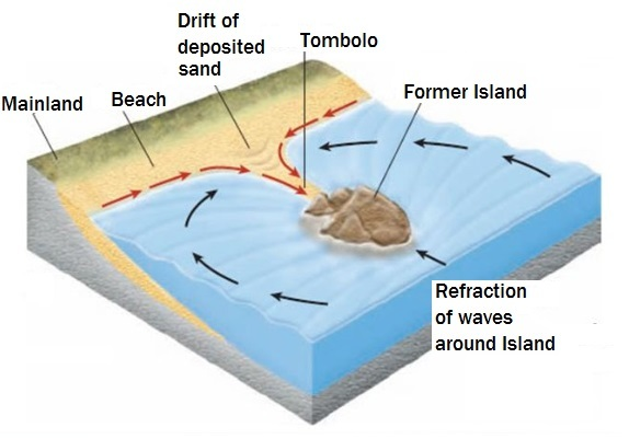
what is a tombolo?
a narrow strip of land, often made of sand or shingle, that connects an island to the mainland, or 2 islands together (has two proximal ends)
what 2 ways are a tombolo formed?
longshore drift
wave diffraction and refraction
how are tombolos formed (1.)?
longshore drift occurs, pushing sediment towards the beach at an angle.
instead of landing on the beach the sediment begins to build up between and an island, creating a bar, attaching the island to the mainland.
this drift is often influenced by the wind direction.
when created by LSD their formation is sometimes not considered a true tombolo.
e.g. Chesil beach, Dorset. 18 mile tombolo that connects the Isle of Portland (4 miles long with a population of around 12,400)
considered by some to not be ‘true’ tombolos
how are tombolos formed (2.)?
waves move toward the coastline and are slowed down as they enter the shallower water.
they reach the islands that are close to the shore first.
because these waves are moving at a slower than normal pace, they move around the island instead of over it.
as the water moves more slowly around the island, it picks up sediment along the way.
when the waves meet on the other side of the island (the side facing the coast), the sediment is deposited.
this sediment continues to build up until it creates the sandbar that connects the island to the beach
diagram of formation of a tombolo through wave refraction
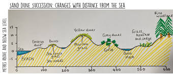
what conditions are needed for a sand dune to form?
wide sandy beach that dries out at low tide
a strong, prevailing, onshore wind to carry the sand up the beach
some sort of obstacle at the top of the beach (e.g. driftwood or a plant) to cause the wind to deposit the sand
development of a sand dune
sand dunes develop over time, slowly building the land out into the sea. in a well-defined series of dune ridges each with its own distinctive size and plant life.
sand carried up the beach by saltation
embryo dunes are the first to form
provide a very harsh environment for plants
very dry
have a high pH
only a few nutrients in the ever shifting sand
only very hardy plants survive (pioneer species, halophytes) in the halophytic conditions like sea buckthorn
these plants help more sand to build up to form fore dunes
as the pioneer species grow and die, they add organic matter to the soil
this allows more water to be retained
which makes the environment less harsh
marram grass starts to dominate the ecosystem
it traps more sand, but can grow quickly to keep up with the growth of the dunes
a high ridge of mobile yellow dunes develop
as more plants grow and die down, the soil becomes richer and moister
therefore, a range as herbs and shrubs start to grow, such as dandelions and brambles
this extra organic content means that semi-fixed grey dunes develop
sometimes the sand is exposed to the wind and it blows away
this lowers the surface
if the surface is lowered until it reaches the water table a dune-slack is formed
water loving plants such as willow shrubs grow
rare amphibians such as the Natterjack toad can breed
eventually trees grow and grey fixed dunes predominate
the development of a coastal sand dune system is an example of plant succession and plant zonation
sand dune succession diagram
plant succession meaning
change in plant species over time
plant zonation meaning
change in plant species over space
offshore bars
Relict
some offshore bars are relict beaches from when sea levels were much lower (during the last ice age)
Other
waves break on the shoreline and transport sediment along the coast through longshore drift
as waves move further offshore, the lose energy and can’t carry the sediment as effectively
the sediment is then deposited, accumulating offshore and forming a submerged ridge
over time, the deposited sediment builds up, creating the offshore bar.
e.g. Bramble beach, Solent, arrow head shaped, the Hoegh Osaka ran aground in 20
mudflats (tidal sedimentation in estuaries)
at the edge of estuaries
zones of net deposition of fine sediment, over time they may develop into saltmarshes
(see saltmarshes)
what does the prefix ‘halo’ mean?
saline
what does the prefix ‘hydro’ mean?
water
what does the prefix ‘xero’ mean?
dry
what does the suffix ‘sphere’ mean?
an environment
they key characteristics of that environment are often put before
e.g. halosphere = salt water
what does the suffix ‘sere’ mean?
refers to the development of plant an animal communities over time - known as succession
e.g. halosere is succession in a salty environment
what does the suffix ‘phyte’ mean?
tolerant
prefixes show what it is tolerant to
e.g. halophytic species can tolerate saline conditions
Drift aligned beaches
transfer sediment along the beach due to the angle of the wave approaching the shoreline at an angle under the influence of the prevailing wind.
large wide beaches struggle to form
beaches associated with a range of depositional features that occur along the coast e.g. spits, tombolos, bars, cuspate forelands.
formation of drift aligned beaches
prevailing winds bring waves in at an angle, which is slightly reduced in the nearshore by wave refraction.
as waves break, swash transports sediment up the beach at an angle, backwash brings it back perpendicular (under the influence of gravity).
so sediment is transported down the beach in a zig zag.
most sediment is suspended in the water, but when moved by the breaking wave it is transported through saltation + traction.
a strong current is also present in the nearshore, called the longshore current, this also transports sediment.
the current varies in strength from beach to beach but works like a stream within a trough between the beach and offshore bar.
rip currents occur at breaks within offshore bar.
swash aligned beaches
occur where waves are parallel to the shore
as a result, build up large beaches, net movement of sediment along the shore is 0.
more influenced by constructive wave patterns (also important for building up large beaches)
mainly associated with large beach profiles, dunes, a variety of berms and beach drainage systems
what are the sources of beach material
cliff erosion - 5%
offshore - 5%
rivers - 90%
Beaches (general)
depositional landforms are produced at coastlines where sand and shingle accumulate faster than they are eroded
this normally occurs in areas of coastline dominated by constructive waves of low energy
beaches are the most common landform of deposition and represent the accumulation of material deposited between positions of the lowest tides and the highest storm waves
beach material takes the form of sand, shingle, pebbles and cobbles
are a dynamic landform with sediment moving along it
sand beaches
produces beaches with a gentle gradient (usually less than 5o )
sand prevents water from infiltrating, small particle size, compact when wet
shingle beaches
steeper (10o - 20o )
infiltration can occur because of bigger gaps, backwash not as strong so material left at top
beach profile
wave energy
high energy waves produce shingle beaches
sandy beaches found in low energy areas
wave type
destructive waves = stronger backwash = more material moving back down the beach = shallower profile
constructive waves = stronger swash = more material moved up the beach = steeper profile beach
sediment calibre
size of sediment - sand vs shingle
strand line
line that marks the position of high tide
dynamic equilibrium in beaches (cycle)
swell waves build up beach as swash is dominant (associated with SUMMER)
this makes the beach steeper
when beach is steep enough it cause approaching waves to be steeper as the increase in friction is so rapid (turns waves into plunging breakers)
the waves now become destructive and begin to comb sediment down the beach (associated with WINTER)
over time this turns the stepper beach shelf into a shallow one
as waves approach he shallow beach, the friction increases more gradually, this leads to spilling breakers
the waves are now constructive again and the strong swash will build the beach back up
Berm
swash aligned
smaller ridges that develop at the position of the mean high tide mark, resulting from deposition at the top of the swash
are generally created by smaller waves which have less energy so that material is smaller
cusps
swash aligned
are semi-circular depressions, they are smaller and more temporary features formed by a collection of waves reaching the same point
the sides of the cusp channel the incoming swash into the centre of the depression and this produces as stronger backwash which drags material down the beach from the centre of the cusp
seem to form when waves approach the beach at 90o but no one really knows how they form, self perpetuating once formed
dip = embayment, high side = horn
ridges and runnels
swash aligned
the spreading out of the wave energy across a wide area of beach tends to produce ridges and intervening depressions called runnels
they are particularly common on shallow, sandy beaches
where to beaches form?
between the high water mark (HWM) and the low water mark (LWM) - in the intertidal zone
beach zones =
backshore
foreshore
nearshore/breaker zone
offshore
backshore zone
usually consists of a storm beach made up of fairly large sediment, mostly pebbles
course sediment is pushed to the top of the beach by storm waves
breaking waves have enough energy to throe pebbles up the beach, but the backwash is usually too weak to pull it back down the beach
berms are formed fortnightly by the spring tide and the two or three slightly lower high tides that follow it
usually 10-20o + above influence of the waves
foreshore
zone between the normal high tide mark and the normal low tide mark
is often made of sand
range of features produced by swash/backwash as tides move in and out
width depends on gradient of beach and tidal range
ridges and runnels formed by constructive waves at different stages of the tide
very dynamic environment, position of features can change with every tide
amount of sand on the foreshore zone depends on the different sources of sediment ant the effectiveness of LSD
usually under 5o
nearshore/breaker zone
between normal low tide level and the level of the lowest spring tides
longshore bars formed by action of waves here
breakpoint bars formed on beaches with low tidal range
offshore zone
always under the water
longshore bars found here, produced when circular movement of wate in the waves starts to touch the sea bed
friction slows wave down, changes in motion of water sweep up sediment to form these bars
in places with very gently sloping beaches and low tidal ranges these bars can become substantial feature and can contribute to the formation of barrier beaches and barrier islands
role of tides
width + nature of foreshore and nearshore determined by the tidal range (as well as by type and amount of sediment)
spring tides shape the berms at the top of the beach
on beaches with a high tidal range, each falling tide reveals a new beach environment, washed clean of any sign of human activity