geo - rivers
1/81
There's no tags or description
Looks like no tags are added yet.
Name | Mastery | Learn | Test | Matching | Spaced | Call with Kai |
|---|
No analytics yet
Send a link to your students to track their progress
82 Terms
erosion
The constant flowing of a river wearing away and removing material from its channel (the river bed and banks).
ways water can be stored
gas, liquid, solid
vapor, water, ice
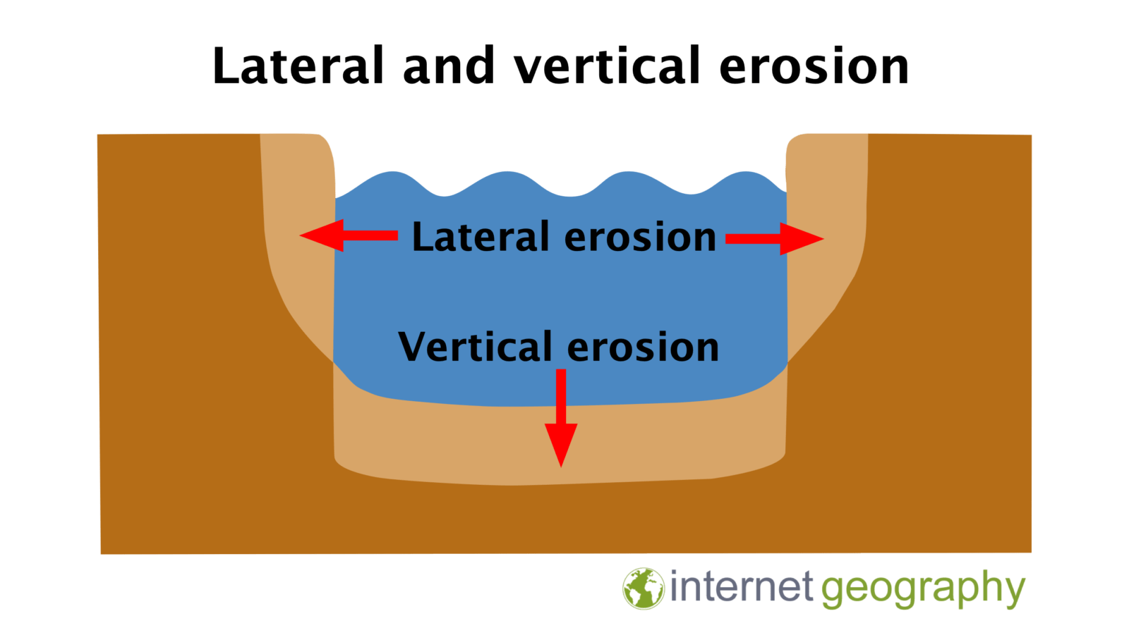
directions of erosion (2)
lateral, vertical
types of erosion (4) - HAAS
HAAS
hydraulic action
abrasion
attrition
solution
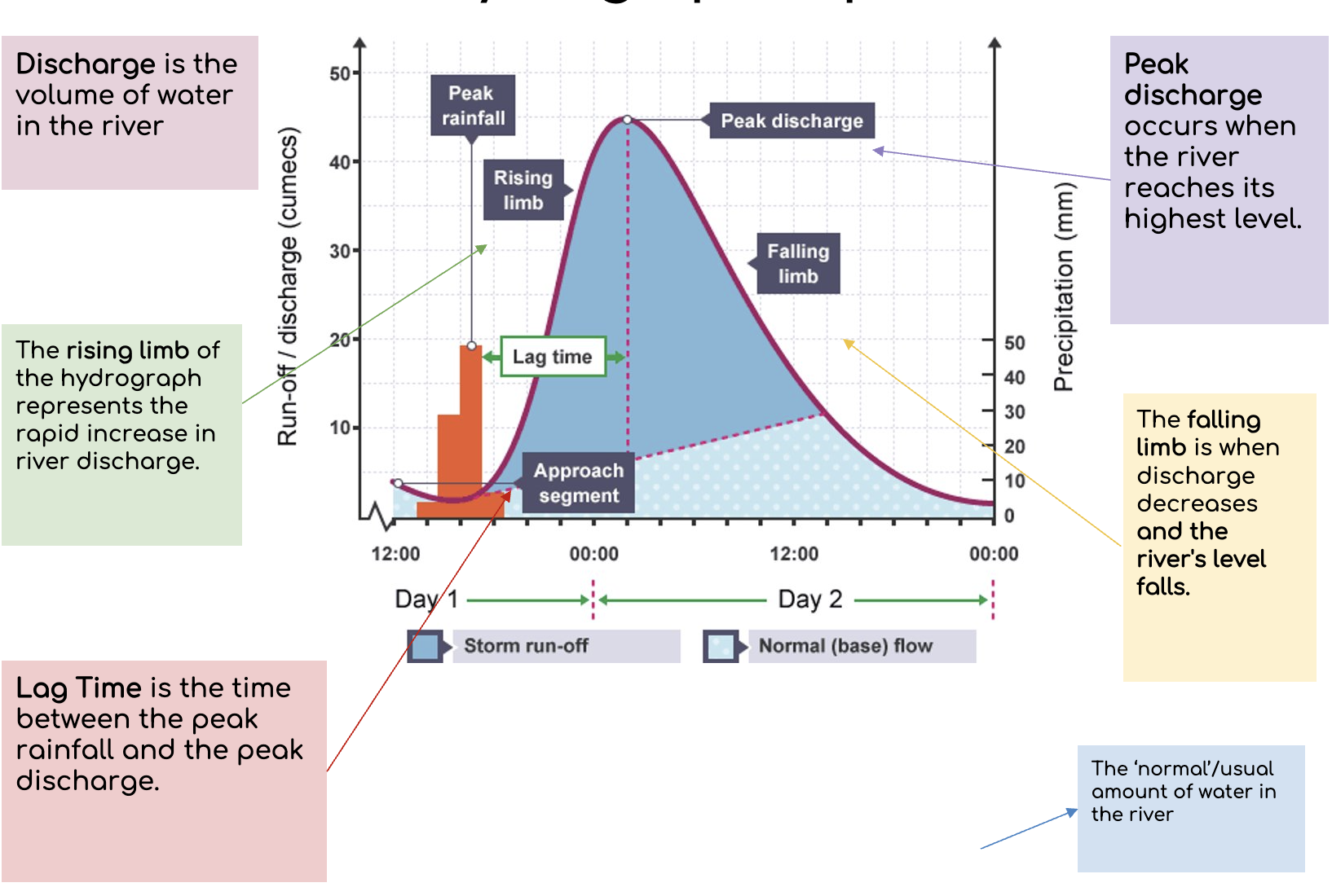
discharge
amount of water within a river during a specific amount of time
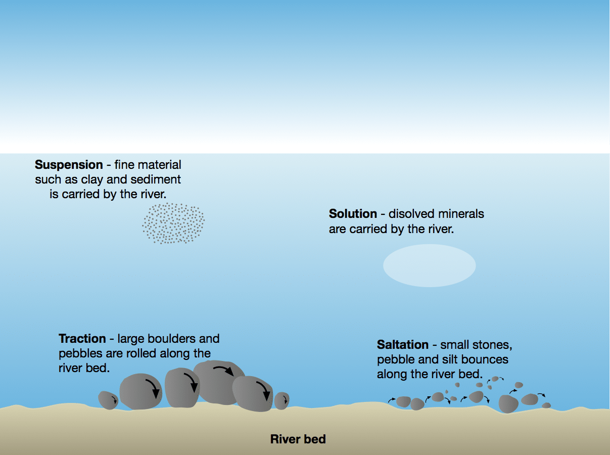
transportation
movement of material via a process
4 types of transportation
3s 1t
traction
suspension
saltation
solution
drainage basin
an area which water resulted from precipitation is collected and drained out through an outlet
watershed
the boundary between drainage basins
tributary
a smaller sized river becoming apart of/ joining a larger river
confluence
the point which two rivers meet/ join together
river source
the starting point of the river
river mouth
the point where a river flows into a larger body of water eg sea/ ocean
hydrological cycle
The processes by which water moves through the landscape / water cycle
what are drainage basins divided by?
watershed
evaporation
The change of water from a liquid to a gas (water vapour) due to heat from the sun
liquid → gas
Condensation
When water cools and changes from water vapour into a liquid (water droplets), forming clouds
gas → liquid
transpiration
process by which plants release water vapor from leaves
Evapotranspiration
The combined transfer of water vapour from the Earth's surface and plants
Precipitation
the process of water falling onto earths surface
provide examples of precipitation
rain
snow
hail
sleet (partly melted snow)
Overland flow
water moving across the surface of the earth
Infiltration
movement of water from surface into the soil
Stem flow/drip flow
Movement of water from vegetation to the ground surface.
Channel Flow
Movement of water confined within a river or stream.
water table
the level below the Earth's surface where the ground becomes wet
what kind of system is the hydrological cycle
closed system
closed system
a system of processes where there is no inputs or outputs - means water cycles continously/ repeatedly
purpose of erosion
makes river channel deeper/ wider
load
material being transported by river
stuff inside the river that is moved by the water
deposition
the removal of the river’s load due to insufficient energy to carry it for longer durations
river dumping load away into river bed cuz it dont got enough energy
what objects/ sediment are deposited first and last by a river?
first - largest and heaviest objects within load (eg boulder)
last - small and lightiest objects within load (silt, mud)
3 courses of a river
upper, middle, lower
which course do you find the most features?
middle
in which course does the river start?
upper
in which course does the river end/ where the mouth is?
lower
mouth is where the river meets the sea
where does vertical erosion occur
upper course
which course does lateral erosion occur in
lower course
velocity
speed that river is flowing at
sediment
material deposited by river
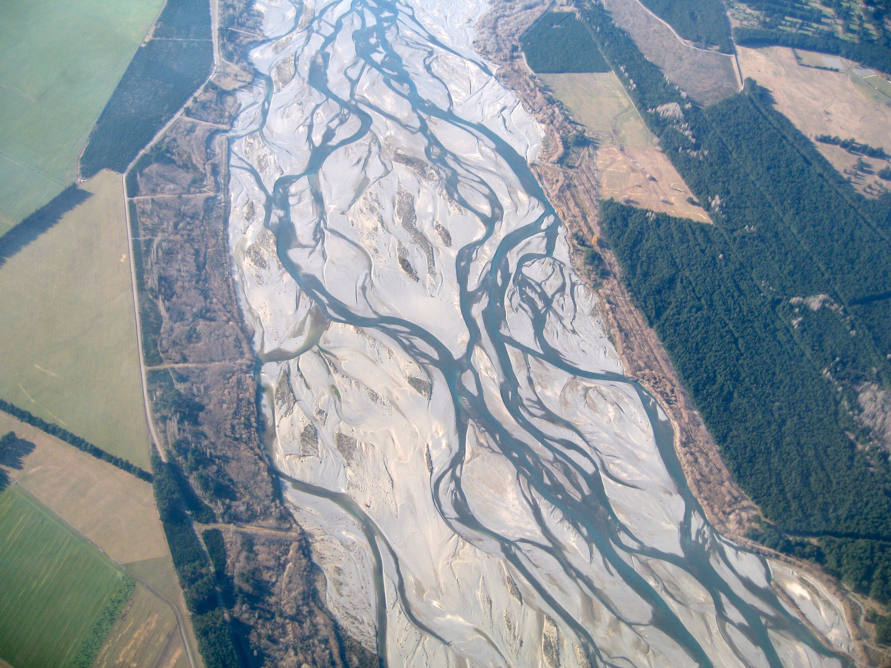
forms of river channel (3)
striaght
braided
meandering
define meandering
when a river flows in broad bends.
define straight
when river flows with few curves
define braided
The river is made up of smaller channels created by material that has been deposited.
looks like a braid
characteristics and features of the upper course
narrower, shallow channel
v shaped/ steep valleys
high bedload
steep gradient
waterfall
gorges
vshaped valley
interlocking spurs
potholes
rapids
characteristics and features of middle course
moderate gradient (not too steep but not to flat)
wide and deep channel
meanders
more volume/discharge
increased biodiversity/life
development of floodplains
slip off slopes
river cliffs
characteristics/features of lower course
very wide and very deep channel
floodplains
flat and wide
ox bow lakes
levees
rapids
sections of a river where the river bed has a relatively steep gradient
located in uppercourse
Form at places where the water is shallow and the river bed is rocky and irregular.
Gradient here is often steeper than at other points on the river’s course.
They can be caused by a band, or bands of hard rock in the river bed.
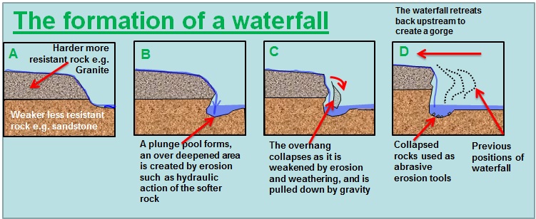
explain the formation of a waterfall
The river flows over bands of less resistant (softer) and resistant (harder) rocks. The less resistant rock is more quickly worn away due to differential erosion. The river erodes the rocks in three main ways:
- Hydraulic action – when the sheer force of the water gets into small cracks and breaks down the rock.
- Corrasion – when the river bed and banks are eroded by the load hitting against them.
- Corrosion – when the river water dissolves minerals from the rocks and washes them away.
The river undercuts the harder rock leaving an overhang which becomes unsupported and collapses into the plunge pool below. After the overhang falls, some of the rocks are swirled around by the river and this helps to form a deep plunge pool below the waterfall. The plunge pool is also deepened during times of high discharge when hydraulic action is most powerful. The waterfall is moved upstream, the process continues, and a steep-sided gorge is cut back into the hillside.
-
Hard rock overlies softer rock / (passes over) hard then soft / alternating
hard and soft;
Hard rock resists erosion / softer rock is eroded rapidly;
Undercutting / overhang develops;
Overhang collapses;
Retreat of waterfall / process repeats;
Specific named methods of erosion or description of (1 MAX)
floodplain
dry land beside river
Floodplains form due to both erosion and deposition.
During a flood, the load is deposited (as the river loses its speed and energy to transport material)
Over time, the height of the floodplain increases as material is deposited with each flood
Floodplains are very fertile because its made up of alluvium (deposited silt from a river flood).
The floodplain is often a wide, flat area caused by meanders shifting along the valley
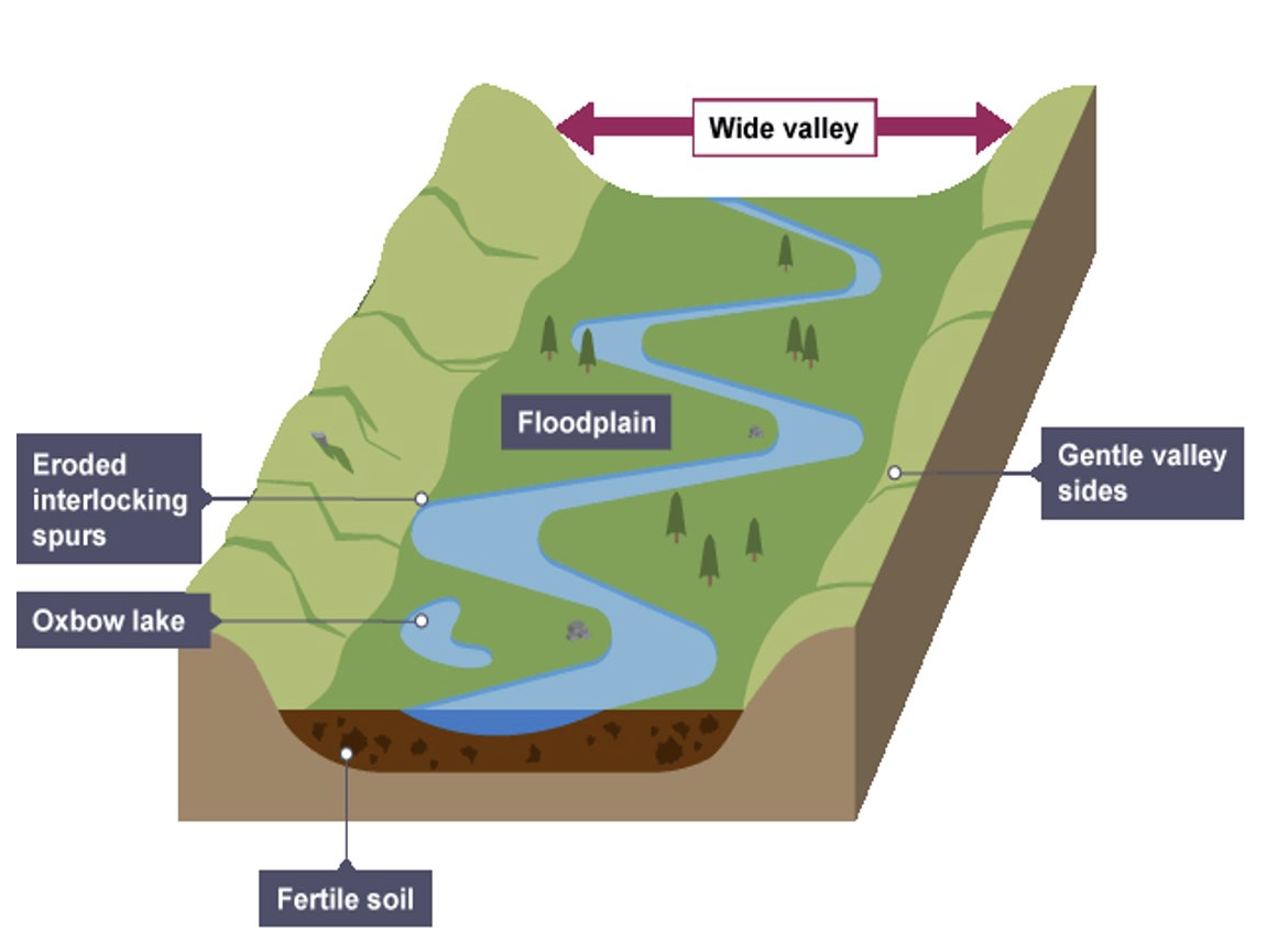
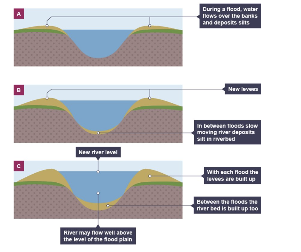
levee
Formed by deposition when the river floods
The river’s load is made of different sized particles - the heaviest is depositied first when the river floods
The larger particles, often pebble-sized, form the leveés.
Levees are raised banks right next to the river banks.
As the water continues to flood further away from the river banks, the sands are deposited next, then the smaller silt
This build up of sand and silt leads to the formation of a flat piece of land (floodplain) either side of the river - just after the levees
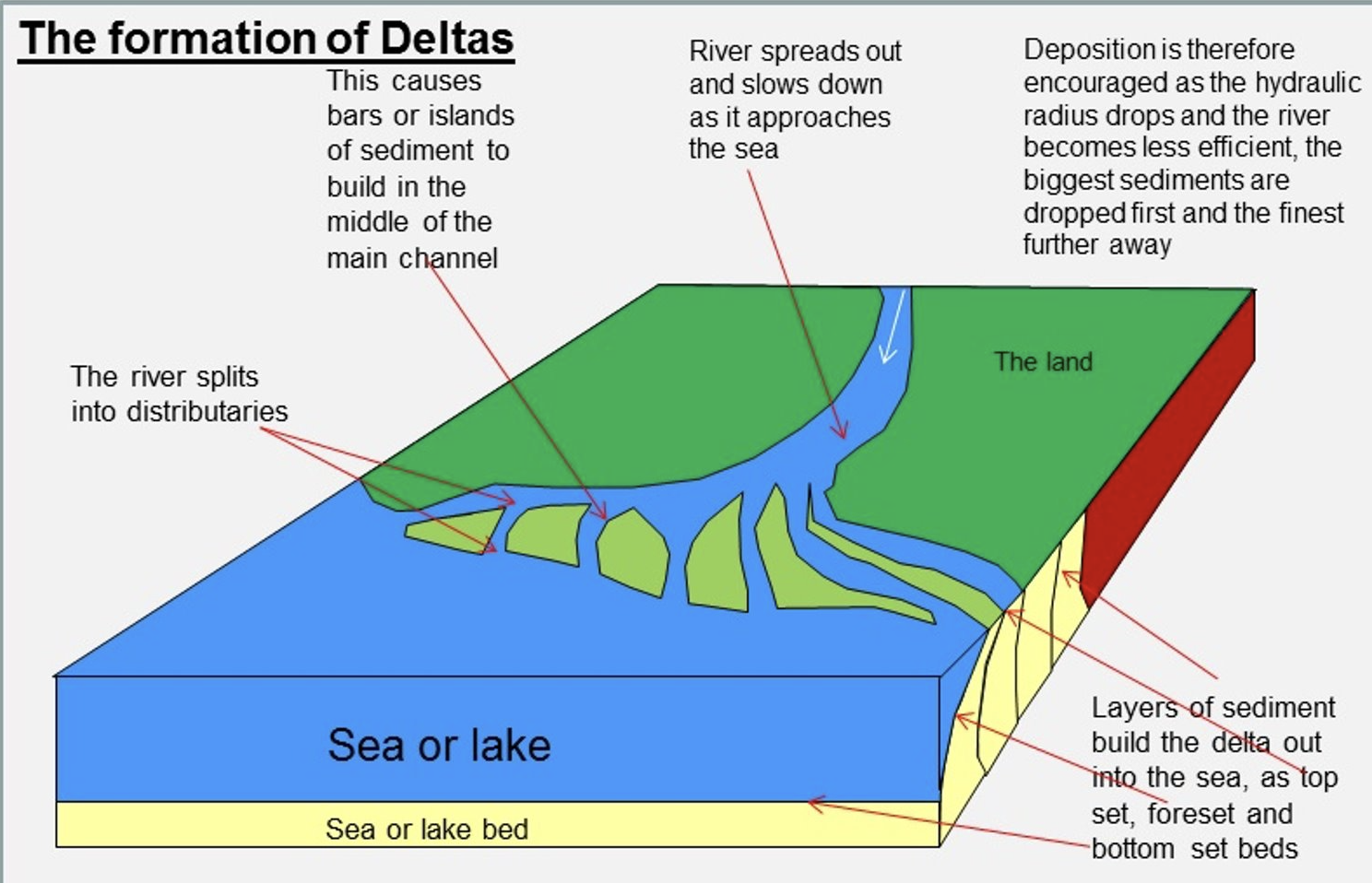
Delta
a delta is formed when the river meets the sea/ at its mouth inwhich the river has been transporting its load. however, the river gradually loses energy and therefore has to deposit its load at the mouth, blocking the channel and causing the river to divide into smaller distributaries.
3 types of deltas - CAB
CAB
cupsate
arcuate
birdsfoot
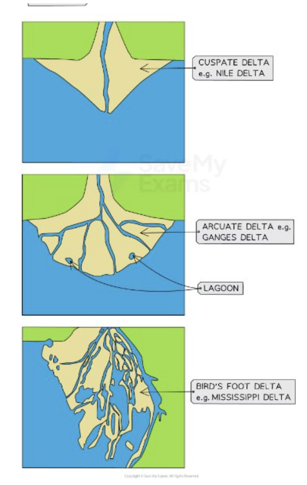
cupsate delta - provide an example and describe the formation
formed when sediments are despoited onto a straight shore with strong waves, inwhich push the sediment to spread outwards and create a tooth shape.
eg - nile
arcuate delta - provide an example and describe the formation
fan/arc-shaped. Formed where wave action is not strong enough to completely redistribute sediments
eg. ganges
birdsfoot delta - provide an example and describe the formation
formed when rivers have lots of sediment - follows normal delta formation process
eg - mississippi delta
hazards/ disadvantages of living near rivers
erosion
destory nearby housing, roads, farm
risks of flooding
disease such as malaria from unhygenic and dirty water
water will encourage mosquitos and other insects to lay eggs - increasing risk of disease they may bring
wild animals inflitration of villages such as snakes and crocidles
destruction of valuable and or expensive resources
hospitals and schools
equipment
death
some cant swim - drown
some misjudge water depth and velocity - water swallows em a
starvation
food resource scarcity
perks/ advantages of living near rivers
fertile soil
farming of valuable crops bywhich farmers can sell to make larger profits
transportation
Residents can trade with nearby towns
flat land
benefits construction by providing stable base/ ground
attractive scenery
peaceful
no distractions
diverse options recreational activties
fishing, kayaking, paddling
indus river general info
over 5 mil people lived
nearly 270 million people depend on it as a water source
Countries:
The Indus River flows through China, India, and Pakistan. It also passes through the disputed region of Kashmir and has a small portion in Afghanistan.
Source:
The river originates near Lake Manasarovar on the Tibetan Plateau in western China. It is also associated with the Upper Gê'gyai source in the Ngari Prefecture.
Course:
The Indus River flows northwest through the Himalayas and Karakoram mountain ranges, then southward through Pakistan. It passes through regions like Ladakh, Gilgit-Baltistan, Khyber Pakhtunkhwa, Punjab, and Sindh before emptying into the Arabian Sea near Karachi.
Length and Basin:
The Indus River is approximately 3,180 kilometers (1,976 miles) long and has a vast drainage basin covering about 1.12 million square kilometers across the four countries.
Tributaries:
The river has several major tributaries, including the Kabul River, Jhelum River, Chenab River, Ravi River, and Sutlej River.
hard engineering
the construction of expensive artificial structures to try and manage the flow of a river
examples of hard engineering
dams
resovoir
flood relief channels
straightening channels
Embankments/ artificial levees
River dredging - River dredging is the process of removing sediment, debris, or other material from bed
Bridge design
advantages and disadvantaes of hard engineering
adv
immediate result (protection against erosion and floods)
Visibility provides a higher sense of protection for people
dis
expensive
not enviormenta friendly
possibility of failure
worsen floods
alteration of natural enviorment
soft engineering
the use of natural and environmentally friendly processes to manage a river and not artificial construction
gorge
narrow and deep valley caused by waterfall retreat
examples of soft engineering
afforestation (planting more trees)
floodplain zoning
warnings and preparation for floods
adv and disadv of soft engineering
adv
enviormentally friendly
has less impact on enviormental
does not involve the construction of large, unaesthetically pleasing structures
protects biodiversity, ecosystem and landscape
offer long term solutions
disadv
might not provide enough protection against severe floods
longer development duration
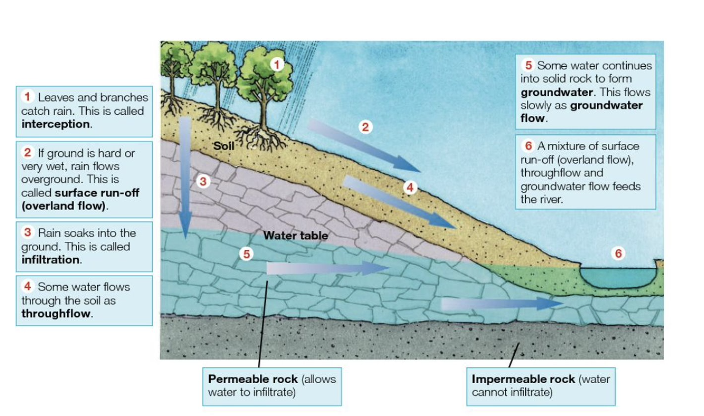
How does water get into a river in the first place?
Leaves and branches catch rain. This is called interception.
If ground is hard or very wet, rain flows overground. This is called surface run-off (overland flow).
Rain soaks into the ground. This is called infiltration.
Some water flows through the soil as throughflow.
Some water continues into solid rock to form groundwater. This flows slowly as groundwater flow.
A mixture of surface run-off (overland flow), throughflow and groundwater flow feeds the river.
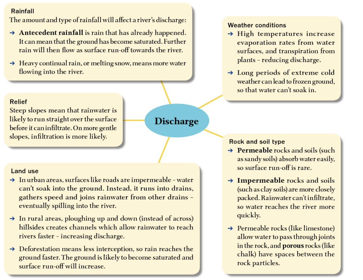
factors affecting discharge
indus river
Causes of the Floods:
Unusually heavy monsoon rains in the Khyber Pakhtunkhwa region
Exacerbated by deforestation, poor river management, and infrastructure failures
River Management Issues:
Impact of dams and barrages on water flow and sedimentation
Levee failures, notably the breach at the Tori Bund, worsened the disaster
Impacts of the Floods:
Nearly 2,000 fatalities and displacement of around 20 million people
Destruction of over 1.2 million homes and loss of livelihoods for millions
Estimated economic loss of approximately $43 billion USD
Destruction of over 2 million hectares of crops like cotton, rice, and sugarcane
Responses and Management:
Emergency response led by the NDMA and military with rescue and relief operations
UNDP's Early Recovery Programme for restoring livelihoods and critical infrastructure
Challenges in the long-term recovery process due to inadequate community involvement, lack of resources, and poor coordination among stakeholders
why do floods occur
destruction of flood prevention tatics (dams, resoviors, levees)
ill preperatation
heavy rainfall
river channel blockage
rapid melting of snow
what are artifical levees called
embankments
what is dredging
process of removing sediment and or other materials from river bed
things to include when asked ‘describe location of…’
compass points
use key
name structures if applicable
define solution
when water dissolves coarse/fine material from bed an dbanks
name the 3 river processes
deposition
transportation
erosion
define hydraulic action
when the river is at high velocity, the water seeps into cracks within the bank, causing a breakage.
define abrasion
when rocks and stones grind against the river bed and bank, causing gradual wear
define attrition
when rocks and stones clash against eachother, knokcing bits off of eachother
define load
eroded material
define sediment
load that is despoited by the river
define solution
water dissolving minerals from bed and banks