TRAFFIC SIGNS
 Call Kai
 Learn
Learn Practice Test
 Spaced Repetition
 Match
Match Flashcards
 Knowt Play
1/93

Earn XP
Description and Tags
Name | Mastery | Learn | Test | Matching | Spaced | Call with Kai | Chat |
|---|
No analytics yet
Send a link to your students to track their progress
94 Terms
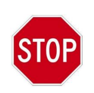
Stop Sign
Driver must stop completely at the designated stop line; parking is strictly prohibited within 6 meters of this sign.
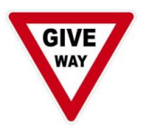
Give Way Sign
Requires the driver to slow down and yield the right-of-way to vehicles on the right side of the intersection.
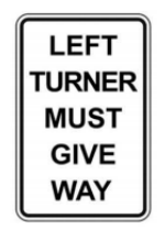
Left Turner Must Give Way
Explicitly commands vehicles turning left to yield to oncoming straight-through traffic before completing the turn.
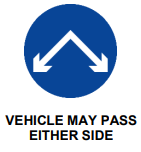
Vehicle May Pass Either Side
Informs motorists that they can legally and safely navigate around an obstruction by passing on either its left or right side.
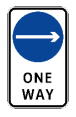
One Way
Indicates that all vehicle traffic must flow exclusively in the direction indicated by the arrow.
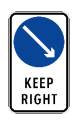
Keep Right
Mandates that drivers must keep their vehicle to the right side of a traffic island, median, or upcoming road obstruction.
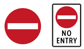
No Entry for All Types of Vehicles
Completely bars any and all motorized vehicles from entering the designated street or roadway.
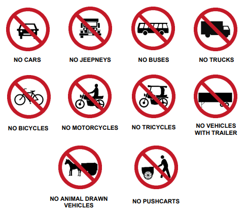
No Entry for Specific Vehicle Types
Restricts entry for designated modes of transport such as cars, jeepneys, tricycles, buses, trucks, or bicycles depending on the graphic shown.
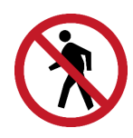
No Pedestrian Crossing
Strictly prohibits pedestrians from crossing the road at this location to prevent accidents.
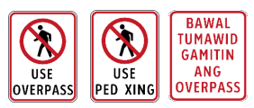
Using Overpass or Use Ped Xing
Commands pedestrians to use the nearby elevated overpass or designated crosswalk for safety.
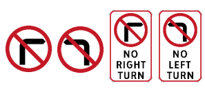
No Right Turn or No Left Turn
Prohibits vehicles from making a right or left turn at the upcoming intersection.
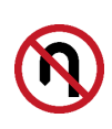
No U-Turn
Prohibits vehicles from reversing their direction of travel to face the opposite way on that stretch of road.
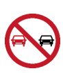
No Overtaking Zone
Prohibits drivers from passing or overtaking other moving vehicles due to limited visibility or high risk.
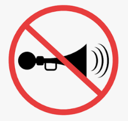
No Blowing of Horn
Prohibits the use of vehicle horns to maintain a quiet zone, typically enforced near hospitals and schools.
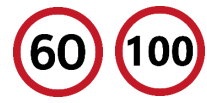
Maximum Speed Restriction
Sets the absolute highest legal speed limit that a vehicle may travel on the roadway under ideal conditions.
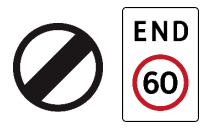
End of Speed Restriction
Signals that the previously posted maximum speed limit regulation is no longer in force.
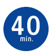
Minimum Speed Restriction
Mandates the minimum legal speed a vehicle must maintain to keep traffic moving efficiently under normal conditions.
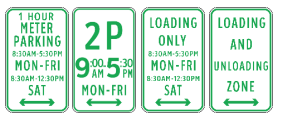
Allowable Parking and Loading Zone
Identifies an authorized area and the specific times where parking or commercial loading is permitted.
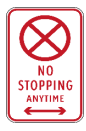
No Stopping Anytime
Strictly prohibits a driver from bringing their vehicle to a halt for any duration, regardless of whether passengers are inside.
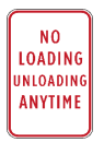
No Loading and Unloading Zone
Prohibits vehicles from stopping to pick up or drop off passengers, cargo, or freight.
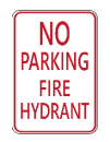
No Parking on Fire Hydrant
Strictly prohibits parking a vehicle within 4 meters of any fire hydrant to ensure emergency access.
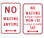
No Waiting
Prohibits vehicles from remaining stationary or idling along the designated roadside zone.
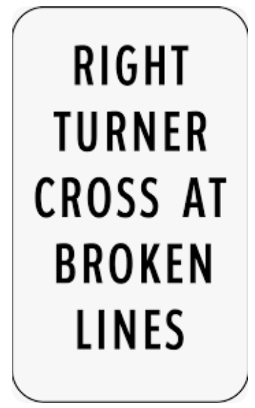
Right Turner Cross at Broken Lines
Permits vehicles from the left lane to cross over broken lines to execute a right turn within a designated transit zone.
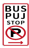
Bus-PUJ Stop Zone
Designates a stopping area exclusively for buses and public utility jeepneys; parking or waiting for other vehicles is strictly illegal.
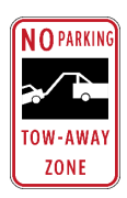
No Parking: Tow-Away Zone
Prohibits vehicle parking at all times; any vehicle found violating this rule will be immediately towed.
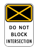
Yellow Box Intersection
Dictates that drivers must never enter or stop inside the yellow grid if their exit lane is blocked, keeping the junction clear.
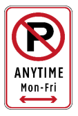
No Parking Anytime (Mon-Fri)
Prohibits parking a vehicle at any time specifically from Monday through Friday.
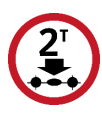
No Entry: Gross Axle Load over 2 Tons
Bars vehicles with a single-axle weight exceeding 2 metric tons from crossing or entering.
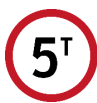
No Entry: Gross Vehicle Mass over 5 Tons
Bars vehicles whose total combined weight exceeds 5 metric tons from entering the road or bridge.
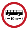
No Entry: Vehicle Length over 10 Meters
Restricts long vehicles or combinations exceeding 10 meters in length from entering narrow or winding roads.

No Entry: Vehicle Width over 2 Meters
Bars extra-wide vehicles measuring over 2 meters in width from entering the roadway clearance.
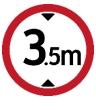
No Entry: Vehicle Height over 3.5 Meters
Restricts tall vehicles exceeding 3.5 meters from entering to prevent collisions with low overhead structures.
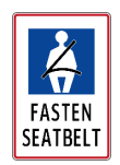
Use Seat Belt Sign
Reminds occupants to fasten their seat belts at all times in compliance with RA 8750 (the Seat Belt Law).
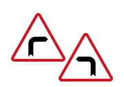
Sharp Turn
Alerts drivers to a looming, severe single sharp bend in the road alignment ahead.
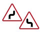
Double Sharp Turn
Warns of two consecutive, highly severe sharp bends in opposite directions ahead.
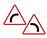
Curve
Warns of a gradual, continuous curve in the road geometry ahead.
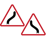
Double Curve
Warns of two consecutive, gradual curves in opposite directions ahead.
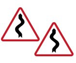
Winding Road
Warns of a series of three or more consecutive curves or bends ahead; drivers must slow down.
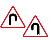
Hairpin Bend
Warns of an extremely sharp, 180-degree U-shaped turn that loops directly back on itself.
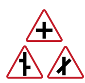
Intersection Ahead
Warns of an upcoming cross-junction where roads intersect perpendicularly.
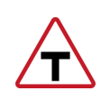
T-Junction Ahead
Warns that the current road terminates directly into a perpendicular crossroad ahead.
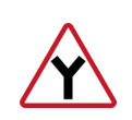
Y-Junction Ahead
Warns that the road splits into a fork ahead forming a Y-shape alignment.
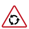
Roundabout Ahead (Rotunda)
Warns of an upcoming circular traffic junction where drivers must yield to vehicles already inside the circle.
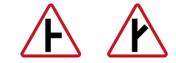
Side Road Junction Ahead
Warns of a side road joining the main highway ahead at an angle from the left or right.

Approach to Intersection Merging Traffic
Warns that side traffic is entering and merging into the main highway lane ahead.
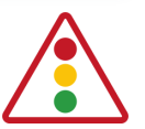
Traffic Lights Ahead
Warns of a signalized intersection ahead; drivers must not park or stop within 6 meters of this sign.
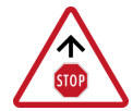
Stop Sign Ahead
Warns that an absolute regulatory STOP sign is approaching around the curve or over the crest.
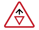
Give Way Sign Ahead
Warns that a regulatory GIVE WAY junction is approaching; prepare to yield.

Road Narrows Ahead
Warns that the printable driving surface or lane width is constricting from one or both sides.
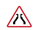
Narrow Bridge Ahead
Warns of an upcoming bridge structure that has a narrower physical width than the approach road.
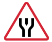
Divided Road Ahead
Warns that the single roadway is about to split into a divided highway separated by a physical median island.
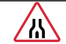
End of Divided Road Ahead
Warns that the physical median barrier ends and the road transitions back into a two-way undivided street.
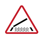
Opening Bridge Ahead
Warns of a drawbridge or movable bridge ahead that may open to allow boat traffic, halting road vehicles.
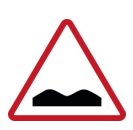
Uneven Road Ahead
Warns of a degraded, rough, bumpy, or uneven road surface that requires reduced speed.
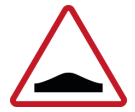
Hump Ahead
Warns of a deliberate, raised speed hump built onto the pavement to force lower speeds.
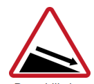
Downhill Sign
Warns of a steep downward incline ahead; drivers should prepare to use lower gears to save brakes.
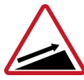
Uphill Sign
Warns of a steep upward incline ahead that may require more engine power or lower gears.
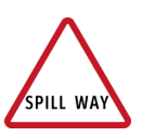
Spill Way Sign
Warns of an upcoming low-water crossing or spillway where water may flow across the road surface.
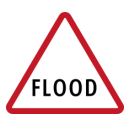
Flood-Prone Area
Warns drivers that this low-lying section of the road is subject to sudden and deep flooding during heavy rains.
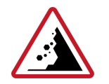
Landslide-Prone Area
Warns of danger from loose rocks, mud, or earth debris falling onto the highway surface.
Slippery Road
Warns that the driving surface becomes highly hazardous and slick, significantly reducing tire traction.
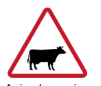
Animal Crossing Ahead
Warns of a specific rural or wilderness area where farm or wild animals frequently wander onto the road.
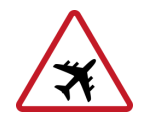
Low-Flying Airplane Zone
Warns of low-altitude aircraft passing overhead due to an adjacent airport runway or flight path.
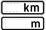
Distance to Next Hazard
Provides exact distance metrics to inform drivers how far ahead a specific road hazard begins or spans.

Vertical Clearance
Displays the maximum absolute height allowed for vehicles passing under an upcoming bridge or overhead obstacle.
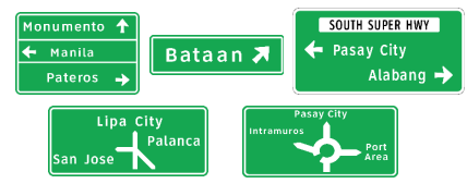
Advance Direction Signs
Placed before an intersection to guide drivers into the correct lanes for reaching specific destinations.
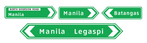
Intersection Direction Signs
Positioned less than 1 kilometer before an intersection to indicate the exact turn points for specific towns.
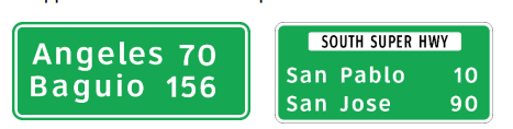
Reassurance Direction Signs
Reaffirms that the driver is on the correct route and lists the remaining distance to major towns ahead.
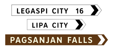
Fingerboard Direction Signs
Small, arrow-tipped directional pointers used to identify minor roads, tourist attractions, or local scenic points.
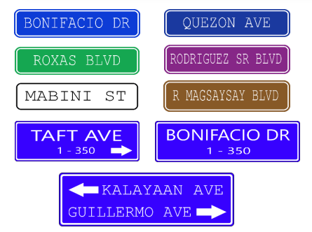
Street Name Signs
Provides the official name of the specific street or road that the motorist is currently passing or entering.
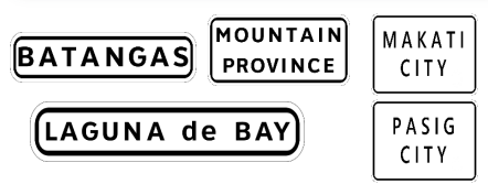
Town Names and Geographical Feature Signs
Conveys general information of interest including municipal boundaries, provincial lines, rivers, or landmarks.
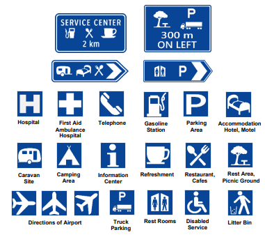
Service Signs
Inform motorists of nearby essential public facilities and amenities such as hospitals, gas stations, or restrooms.
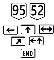
Route Markers
Displays the official identification number assigned to a specific national or arterial highway route.
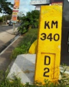
Kilometer Zero Marker
The absolute national distance reference post located in Luneta Park, Manila (and provincial capitals) used to calculate all highway distances.
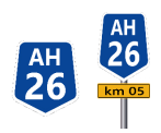
Asian Highway Route Markers (AH26)
Identifies international through-routes across the Asian Highway Network; route number AH26 is assigned to the Philippines.
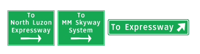
Expressway Approach Signs
Installed in advance of major intersections or interchanges that feed directly into an expressway system.
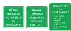
Prohibited on Expressway
Informs road users of specific prohibited traffic such as pedestrians, bicycles, or slow vehicles banned from entering the expressway.
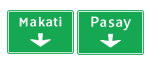
Lane Direction Sign
Positioned overhead to explicitly guide fast-moving motorists into the correct lanes leading to a specific interchange.
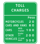
Toll Charges Sign
Informs approaching drivers of the exact mandatory toll fees required for each vehicle class at the upcoming plaza.
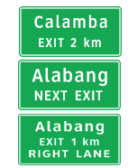
Advance Exit Signs
Positioned well in advance of an interchange ramp to give drivers ample time to change lanes safely before exiting.
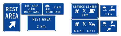
Expressway Service Signs
Placed in advance to display the distance, direction, and availability of rest areas, fuel, or food along the expressway.
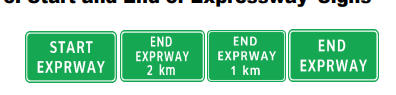
Start and End of Expressway Signs
Marks the exact physical boundary where specialized expressway traffic regulations begin or cease to apply.
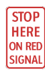
Stop Here on Red Signal
Commands drivers to bring their vehicle to a complete stop exactly at the painted stop line when the traffic light is red.
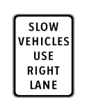
Slow Cars Stay Right
Instructs slower-moving vehicles to keep to the rightmost lane to allow faster traffic to pass safely on the left.
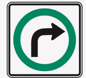
Turn Right on Green Light Only
Explicitly prohibits making a free right turn on red; drivers must wait for a green arrow or signal.
Left/Right Turn if Intersection is Clear
Permits a driver to turn on a red signal or junction only after making a full stop and ensuring cross-traffic is clear.
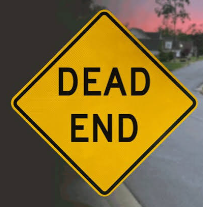
Approaching Dead End
Warns the driver that the road terminates completely ahead, offering no throughway or exit.
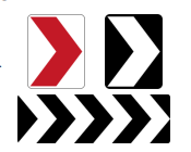
One-Way Hazard Markers
Alerts drivers to a sudden termination of the road or a sharp barrier, indicating the single allowed direction of travel.

Two-Way Hazard Markers
Warns that the road splits or features an obstruction directly ahead, allowing vehicles to pass on either the left or right side.
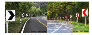
Chevron Signs
Guides drivers through a progressive and hazardous change in the horizontal alignment or curve of the road.
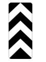
Overpass/Median Structure Marker
Installed directly on wide columns, overpass structures, or median noses to warn of a solid physical block.
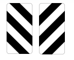
Width Markers
Placed near bridge approaches or narrow structures to warn of a reduction in lateral or horizontal clearance.
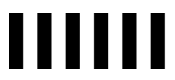
Obstruction Markers / Road Closed
Signals that the road is blocked or undergoing closure ahead, requiring immediate detour or stopping.
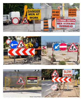
Road Work Ahead
Alerts drivers that a construction, maintenance, or roadwork zone is active ahead; slow down and prepare for hazards.