Lecture 1-4:
 Call Kai
 Learn
Learn Practice Test
 Spaced Repetition
 Match
Match Flashcards
 Knowt Play
1/49

There's no tags or description
Looks like no tags are added yet.
Name | Mastery | Learn | Test | Matching | Spaced | Call with Kai | Chat |
|---|
No analytics yet
Send a link to your students to track their progress
50 Terms
What is the Moisture Equation?
Deals with the concepts of evaporation, condensation and mixing of moisture in the atmosphere. Despite a change of state, the mass of moisture remains the same. All moisture losses from the land surface and oceans will be balanced by gains due to precipitation and condensation. The equation is:
change in moisture = change due to evaporation + change due to condensation - change due to vertical mixing
*how much water added to atmosphere from underlying surface, associated with cooling/cloud formation, dispersion or dilution of moisture in atmosphere
What is the effect of global warming on precipitation?
Hydrological balance has been thrown out of kilter as a result of atmospheric warming
Extreme rain events will increase in intensity by 3-15% depending on region for every °C that the planet warms
The water-holding capacity of the atmosphere increases by about 7% for every 1°C rise in temperature (Clausius-Chapeyron relationship)
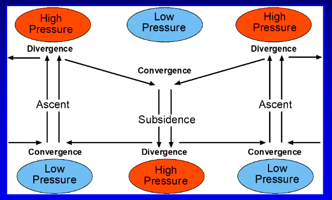
What is the Equation of Continuity?
It describes the principal of conservation of mass that ‘no matter how much air is compressed or stretched, air will not change its mass’. By compressing air at one place, it must be balanced by expansion at another. The equation is:
vertical convergence = horizontal divergence + a density change
horizontal convergence = vertical divergence + a density change
Electromagnetic radiation
The higher the temperature of the object emitting radiation, the shorter the wavelength of radiation emitted.
The higher the temperature of the object emitting radiation, the greater the amount of radiation emitted
Radiation from the Sun (0.15 - 3 um) and from the Earth (3 - 100 um) are
of different wavelengths. Why? Because of their distinctly different temperatures, i.e. Sun 6000°K –Earth 300°K
Tropical cyclones divergence convergence
For a tropical cyclone to intensify the rate of divergence (loft) has to exceed the rate of convergence. A more rapid rate of divergence than convergence at the surface will draw in more ‘fuel’.
Electromagnetic radiation
The higher the temp of the radiation emitting object, the shorter the wavelength and the greater amount of radiation emitted
Radiation from the Sun (0.15 - 3um) and from the Earth (3 - 100 um) are different wavelengths
due to their distinct temperatures (Sun 6000°K and Earth 300°K)
What is the amount of solar radiation absorbed at the surface?
The mean solar constant (amount of shortwave) received at the top of the atmosphere from the Sun is ~1368 Wm-2
Net shortwave at the surface equals diffuse shortwave radiation (scattered and reflected) and direct short-wave radiation (without being absorbed/diffused)
Amount of shortwave radiation:
that reaches the surface is dependent on atmospheric turbidity (e.g. aerosols, water vapour etc.)
absorbed at surface is dependent on surface albedo (e.g. fresh snow = 95%, lava = 10%, thick cloud = 70-95%, urban = 15%)
Solar cycles
We are coming off the top of a solar cycle!
Radiation coming in through the atmosphere is not constant, it oscillates every 10-11 years
Auroras (solar flares caused by higher increase in frequency and incidence of high energy electromagnetic particles hitting top of atmosphere) at peak of cycle
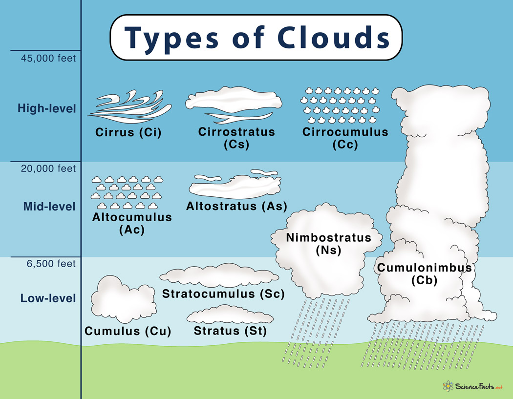
What cloud properties influence the radiation budget?
Cloud height
Coverage of sky
Cloud thickness
Moisture content
Persistence
Cloud composition
Layers of cloud
Measurement of radiation transfers
Pyranometers measure short wave; pyrgeometer measure long wave
CM21/CG4
CNR 4
Radiation sensor on a flux tower
What is the driving force behind our weather and climate?
The Radiation Balance
the global distribution of net radiation (Q*) primarily drives atmospheric circulation (note Q* can be position or negative)
causes change in air density at surface to set up pressure gradient and drive sea breeze convection etc.
Q* = K ↓ - K ↑ + L ↓ - L ↑
(K = shortwave, L = longwave)
*incoming longwave is determined by cloud coverage and GHGs
note the variables display, diurnal, seasonal, and latitudinal variability also influenced by surface type (albedo)
Energy loss (as whole)
Energy receipt equals energy loss for the Earth-Atmosphere system as a whole (in radiative equilibrium).
69 units of short-wave remaining in the system [100 - 8 (backscattered) - 17 (reflected from clouds) - 6 (reflected from surface)] = 69 units of long-wave leaving system [9 (lost directly from surface) + 40 (emitted from top of atmosphere) + 20 (emitted from clouds)].
Energy loss (when Earth and Atmosphere are conceived separately)
The Earth and Atmosphere are not in radiative equilibrium.
Surface [46(short wave absorbed) - 115(long wave emitted) + 100(long wave absorbed from the atmosphere) = +31],
Atmosphere [23(short wave absorbed by atmosphere) + 106(longwave radiation absorbed by atmosphere) - 100 (long wave emitted to the surface of atmosphere) - 60 (long wave emitted from atmosphere to space) = -31]
What brings the system into radiative equilibirum?
Balance is brought back by net transfer of energy from the surface to the atmosphere by convection (i.e. 24 units from latent heat, while 7 units from sensible heat)
Sensible heat
Sensible heat can be sensed it is that portion of total heat associated with temperature change (ΔT)
Sensible heat per unit mass of air (mair) is given by:
Cp.ΔT = ΔQH/mair
*Cp is specific heat of air (dry or moist)
Latent heat
Latent heat is either removed (absorbed or released with a change in phase of water)
Latent heat is the amount of heat per unit mass of phase changed water (mwater) given by:
L = ΔQE/mwater
*this value differs for condensation or vapouristion, freezing or melting, deposition or sublimation.
Surface Energy Balance
Any surface radiative imbalance (+Q*) is accounted for by the combination of convection exchange either to or from the atmosphere in the form of (the partitioning of) Qh (sensible heat), Qe (latent heat) and conduction in to or from the soil/water (Qg)
Q* (net radiation - limit of available energy source or sink)
Q* is basic input into the surface energy balance which is:
Q* = Qh + Qe + Qg + ΔQs
*ΔQs is change on heat flux storage (computed as residual usually) due to unaccounted watts in field
The difference between Radiation Budget and Energy Balance
Partitioning of the Radiative Surplus or Deficit
Exact partitioning of the radiative surplus between Qh, Qe, Qg is governed by surface type and the ability of atmosphere and soil to transport heat
Over a moist surface during the day Q* would be dissipated as Qe, Qg and Qh in decreasing order of importance
Where availability of moisture restricted, we would expect Qh to dominate, then Qe and Qg (dry desert surface)
Direct measurement of energy balance is done most effectively using Eddy Covariance method
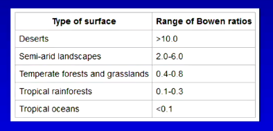
Bowen Ratio
Landscapes can be classified based on their energy balances (mean energy flux characteristics of a surface). It is the ratio of sensible to latent heat flux.
β = Qh/Qe
Factors that influence the energy balance
Changing energy received from the sun (seasonal, diurnal, solar variability etc.)
Earth-Sun geometry
Change in atmospheric composition (e.g. gas, dust and aerosols)
Changing surface characteristics (e.g. albedo, moisture)
Changing cloud cover (e.g. type, height, thickness)
Changing atmospheric circulation and associated weather (cold dry air advection over warm surface)
What is the relationship between the Energy Balance and weather?
Surface energy balance determines air temperature
Change in air temp of a parcel of air will result in change in its density/ pressure (Equation of State)
these changes result in air motion (convection - vertical/advection - horizontal)
Evaporation from the surface increases water vapour and results in cooling by removing sensible heat and storing it as latent heat
e.g. evaporation of raindrops results in decrease of air temperature and an increase in air density (negative buoyancy)
Condensation of water vapour (i.e. cloud formation) will release latent increasing air temperature resulting in a change in air density that may enhance positive buoyancy and cause convections (vertical motion of air)
Energy balance and Sea Breeze
By day more Q* is converted into Qh over land than over water, establishing a Qh gradient across the land – water interface
creates higher ambient air temperatures over land relative to those over
the adjacent waterresults in decreased air density in the boundary layer over land and a subsequent development of a pressure gradient from over the cool ocean to over the warm land
In-turn sets in motion the movement of air from over the water to the land (Sea Breeze)
the reverse occurs at night following sunset (return flow aloft blows (continuity of mass))
Microburst
Downbursts are a microfeature most often created by an area of significantly precipitation-cooled air that, after reaching the surface (subsiding), spreads out in all directions producing strong winds.
Temperature v Height
There are three properties of a vertical profile of temperature:
a lapse (decreasing temp with height)
an inversion (increasing temp with height)
well mixed (no temperature increase/decrease with height (isothermal))
Lapse rates (adiabatic processes)
Adiabatic processes occur due to changes in volume (density) and internal energy in the absence of outside sources of heat
i.e. no exchange of mass, heat, moisture etc., across the boundary of the air parcel
Lapse rates:
environmental lapse rate = 6°C/km
dry adiabatic lapse rate = 9.8°C/km
(a change in the thermodynamic properties of an air parcel due to a change in pressure)
saturated adiabatic lapse rate = 4 to 7 °C/km
(due to adiabatic processes when
an air parcel is saturated)

Ideal diurnal evolution of vertical temperature profiles
Temperature inversions
Radiative temperature inversions occur at night where layer of air closest to the ground cools much faster than air further away (Q* negative).
produces a stable layer of air next to the ground in which air mixing is inhibited (relevant phenomenon for issues of air pollution and frost hazard)
Subsidence inversions are associated with subsiding air in anticyclones
i.e., as air molecules are squeezed closer together, they are elevated and act as a “lid” on the atmospheric boundary layer (trapping pollutants over cities)
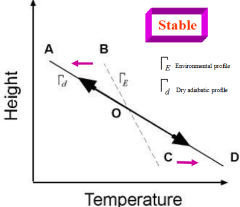
How to determine if an atmosphere is stable?
An air parcel moved up or down from ‘O’ will try and return to its original location
This is because the air temperature difference between the parcel of air and its environmental temperature provides buoyancy (positive or negative)
air parcel does not like to be displaced because it is less cold or less warm than surrounding air
Based on the environmental temperature profile relative to the dry adiabatic lapse rate or the saturated adiabatic lapse rate
Other evidence of a stable atmosphere
Vertical oscillations (mountain waves) caused by topographic deflection of trans-barrier airflow. These typically form in stable atmospheres.
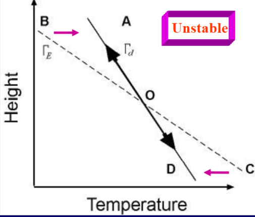
How to determine if an atmosphere is unstable?
Vertical movement of an air parcel up or down from ‘O’ will accelerate as its temperature will be warmer or cooler than the environmental conditions (ΓE) that
surround itair parcel will continue to be displaced because it is warmer or colder than surrounding air
Based on the environmental temperature profile relative to the dry adiabatic lapse rate or the saturated adiabatic lapse rate
How to determine if an atmosphere is conditionally unstable (intermediate)?
In SEQ we typically have a conditionally unstable atmosphere on thunderstorm days
In this situation atmospheric stability is a function of its moisture status
If a parcel of air rises from ‘A’ at the SALR it will be warmer than the environmental air and thus buoyant but if it rises at the DALR it will be cooler and therefore stable (negative buoyancy)
air parcel lies between the dry adiabat and saturated adiabat
Other evidence of an unstable atmosphere
Unstable surface layer (strong heating) caped by a subsidence inversion (limiting vertical cloud development) resulting in fair weather cumulus. Humid fair days followed by stormy evenings in SEQ.
Deep cumulus development in a conditionally unstable atmosphere.
What does each environmental lapse rate say about the stability of atmosphere?
When the environmental lapse rate:
is between the DALR and the SALR the atmosphere is considered to be conditionally unstable;
is steeper than the SALR the atmosphere is considered to be absolutely stable;
is the same as the DALR it is considered to be neutrally stable (neutral);
is less steep than the DALR it is considered to be absolutely unstable
What is LCL?
Lifting Condensation Level (LCL) is the level at which air would become saturated if lifted dry adiabatically.
What is LFC?
Level of Free Convection (LFC) is the level at which a parcel of air lifted dry-adiabatically until saturated and saturation-adiabatically thereafter would first become warmer than its surroundings in a conditionally unstable atmosphere.
What is the LOC?
Limit of Convection (LOC) the level of neutral buoyancy for a saturated rising air parcel.
What is CAPE?
Convective Available Potential Energy (CAPE) is a measure of the amount of energy available to create vertical motion (convection). It is proportional to the area between the SALR and ELR between the LFC and LOC (EL).